June 29th Derecho
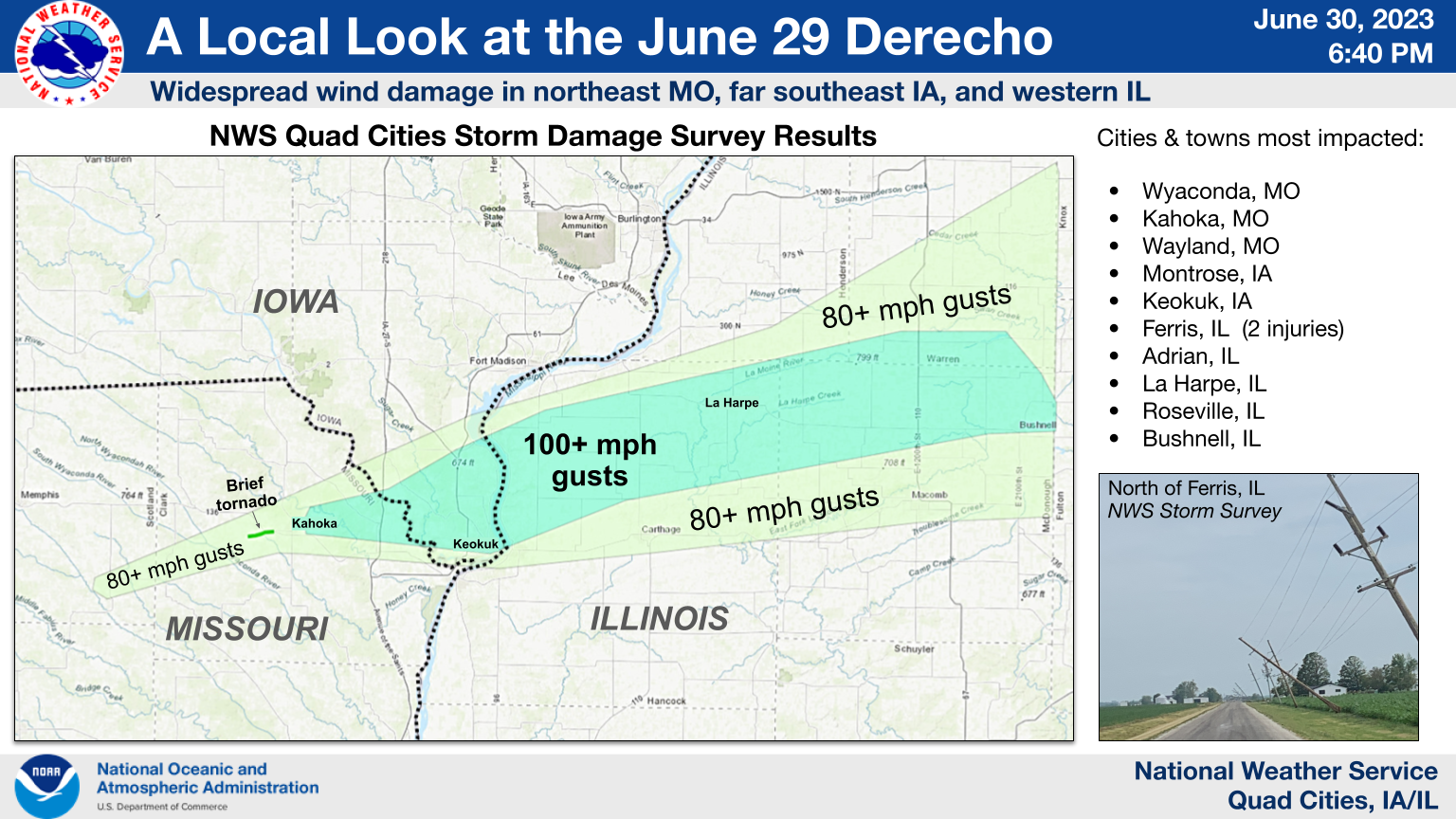
SPC Recap of Severe Weather Event: June 29, 2023​
|
|
 |
 |
|
Tornadoes
|
Tornado - W of Kahoka, Missouri
|
||||||||||||||||
The Enhanced Fujita (EF) Scale classifies tornadoes into the following categories:
| EF0 Weak 65-85 mph |
EF1 Moderate 86-110 mph |
EF2 Significant 111-135 mph |
EF3 Severe 136-165 mph |
EF4 Extreme 166-200 mph |
EF5 Catastrophic 200+ mph |
 |
|||||
Storm Reports
| IEM Local Storm Reports | SPC Severe Weather Event: June 29, 2023 |
 |
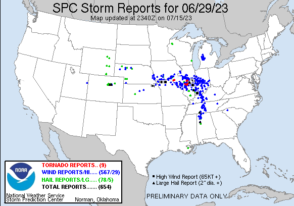 |
Preliminary Local Storm Report...Summary National Weather Service Quad Cities IA IL 817 PM CDT Fri Jun 30 2023 ..TIME... ...EVENT... ...CITY LOCATION... ...LAT.LON... ..DATE... ....MAG.... ..COUNTY LOCATION..ST.. ...SOURCE.... ..REMARKS.. 0921 AM Hail 2 SSE Selma 40.84N 92.14W 06/29/2023 E1.00 inch Van Buren IA Trained Spotter relayed by another spotter. 0947 AM Tstm Wnd Dmg Batavia 40.99N 92.16W 06/29/2023 Jefferson IA Trained Spotter trees down, power out. time estimated from radar. 0947 AM Tstm Wnd Gst Batavia 40.99N 92.16W 06/29/2023 E60 MPH Jefferson IA Trained Spotter 1005 AM Tstm Wnd Dmg South Gorin 40.36N 92.02W 06/29/2023 Scotland MO NWS Storm Survey Corrects previous tornado report from South Gorin. NWS Storm Survey did find a large, partially rotted tree down in this area, as well as several smaller trees downed. Damage was inconclusive for a tornado. 1007 AM Tstm Wnd Dmg Wyaconda 40.39N 91.93W 06/29/2023 Clark MO NWS Storm Survey Damage to trees and trees on structures. NWS survey estimates straight-line winds around 90 mph. Time estimated based on radar. 1007 AM Tstm Wnd Gst Wyaconda 40.39N 91.93W 06/29/2023 E90 MPH Clark MO NWS Storm Survey Damage to trees and trees on structures. NWS survey estimates straight-line winds around 90 MPH. Time estimated based on radar. 1010 AM Tornado 2 SW Medill 40.41N 91.79W 06/29/2023 Clark MO NWS Storm Survey NWS Storm Survey determined an EF1 tornado with peak winds near 90 mph tracked for 2.4 miles from southwest of Medill to just west of Kahoka. Damage to an outbuilding occurred along with convergent damage to numerous large trees. 1018 AM Tstm Wnd Gst Kahoka 40.42N 91.72W 06/29/2023 E100 MPH Clark MO NWS Storm Survey Several buildings with rooftops peeled. NWS storm survey estimates winds of around 90-100 MPH. Time estimated from radar. 1018 AM Tstm Wnd Dmg Kahoka 40.42N 91.72W 06/29/2023 Clark MO NWS Storm Survey Several buildings with rooftops peeled. NWS storm survey estimates winds of around 90-100 MPH. Time estimated from radar. 1028 AM Tstm Wnd Gst Wayland 40.39N 91.58W 06/29/2023 M70 MPH Clark MO Trained Spotter tree limbs down. also dime hail. 1028 AM Tstm Wnd Dmg Wayland 40.39N 91.58W 06/29/2023 Clark MO Trained Spotter 20 inch tree snapped at base. corn layed down and power lines down. 1030 AM Tstm Wnd Dmg 2 NE Hamilton 40.40N 91.34W 06/29/2023 Hancock IL Public Several large to very large tree branches down. Trees snapped as well. Time estimated by radar. 1032 AM Tstm Wnd Gst 1 SSW Mooar 40.44N 91.45W 06/29/2023 E80 MPH Lee IA Trained Spotter 70 to 80 mph wind gusts. 1033 AM Tstm Wnd Dmg 4 N Wayland 40.45N 91.59W 06/29/2023 Clark MO NWS Storm Survey Several large trees snapped. Outbuilding heavily damaged. All along County Road 197. Time estimated using radar. 1033 AM Tstm Wnd Dmg Revere 40.49N 91.68W 06/29/2023 Clark MO Public Large tree limbs down and some small objects tossed around in yard. Time estimated from radar. 1035 AM Tstm Wnd Gst Keokuk 40.41N 91.40W 06/29/2023 E100 MPH Lee IA NWS Storm Survey NWS Storm Survey observed wind damage consistent with gusts around 100 mph in Keokuk. This included dozens of large trees downed, utility poles downed, an outbuilding nearly destroyed, and a roof blown off a home. In addition, a couple mobile homes were severely damaged on the north side of town. 1035 AM Tstm Wnd Gst 1 SE Fairfield Municipa 41.03N 91.97W 06/29/2023 M51 MPH Jefferson IA AWOS AWOS station KFFL Fairfield Arpt. 1035 AM Tstm Wnd Gst 1 E Keokuk Airport 40.47N 91.42W 06/29/2023 M74 MPH Lee IA AWOS AWOS station KEOK Keokuk Arpt. 1037 AM Tstm Wnd Dmg 2 ESE Fairfield 41.00N 91.94W 06/29/2023 Jefferson IA Trained Spotter time estimated. power out and 3 trees down. 1038 AM Tstm Wnd Gst 3 NE Hamilton 40.43N 91.33W 06/29/2023 E60 MPH Hancock IL Trained Spotter cannot see neighbors house. 1040 AM Tstm Wnd Dmg Montrose 40.53N 91.42W 06/29/2023 Lee IA NWS Storm Survey Dozens of large trees downed throughout town. Peak winds consistent with 90 to 100 mph. Time estimated. 1040 AM Tstm Wnd Gst Montrose 40.53N 91.42W 06/29/2023 E100 MPH Lee IA NWS Storm Survey NWS Storm Survey found damage to dozens of large trees and utility poles consistent with peak wind gusts of 90 to 100 mph throughout the town. 1040 AM Tstm Wnd Dmg Nauvoo 40.55N 91.38W 06/29/2023 Hancock IL Trained Spotter major tree damage reported throughout town. 1043 AM Tstm Wnd Dmg Ferris 40.47N 91.17W 06/29/2023 Hancock IL NWS Storm Survey *** 2 INJ *** Corrects previous tstm wnd dmg report from Ferris. Roof ripped off of mobile home, EM confirmed two injuries. Time estimated from radar. 1044 AM Tstm Wnd Dmg Adrian 40.52N 91.17W 06/29/2023 Hancock IL NWS Storm Survey Corrects timing of previous tstm wnd dmg report from Adrian. Communication tower bent over. Winds estimated around 120 mph. 1044 AM Tstm Wnd Dmg Ferris 40.47N 91.17W 06/29/2023 Hancock IL NWS Storm Survey Several power poles snapped near base. Estimated winds around 120 mph. 1045 AM Tstm Wnd Gst 1 E Adrian 40.52N 91.14W 06/29/2023 E100 MPH Hancock IL NWS Storm Survey Grain bin destroyed and rolled into field. Winds estimated at 100 MPH. Time estimated based on radar. 1053 AM Tstm Wnd Dmg 1 NNE Fort Madison 40.63N 91.34W 06/29/2023 Lee IA Trained Spotter tree limbs down. estimated 80 MPH winds. 1053 AM Tstm Wnd Dmg 2 SE Ferris 40.45N 91.14W 06/29/2023 Hancock IL Amateur Radio Several trees across roadway. 1054 AM Tstm Wnd Dmg 1 SE Disco 40.61N 91.00W 06/29/2023 Hancock IL Trained Spotter time estimated by radar. two 18 inch diameter trees downed. numerous tree blanches down. one of the worst storms experienced in 78 yrs. 1055 AM Tstm Wnd Gst 1 S La Harpe 40.58N 90.97W 06/29/2023 E100 MPH Hancock IL NWS Storm Survey Garage outbuilding destroyed, winds estimated at 100 MPH. Time estimated by radar. 1056 AM Tstm Wnd Dmg 1 ESE La Harpe 40.58N 90.94W 06/29/2023 Hancock IL NWS Storm Survey Farm outbuilding destroyed, winds estimated around 90-100 MPH. Time estimated on radar. 1058 AM Tstm Wnd Gst 1 WNW Blandinsville 40.56N 90.88W 06/29/2023 E100 MPH McDonough IL NWS Storm Survey Several tree trunks snapped near the Twin Oaks Golf and Country Club. Winds estimated near 100 MPH. Time estimated on radar. 1058 AM Tstm Wnd Gst 4 E Colusa 40.56N 91.09W 06/29/2023 E80 MPH Hancock IL Storm Chaser time estimated by radar. 1100 AM Tstm Wnd Dmg Washington 41.29N 91.69W 06/29/2023 Washington IA Emergency Mngr Tree down on power line. Time estimated. 1100 AM Tstm Wnd Dmg 2 SW Adrian 40.50N 91.20W 06/29/2023 Hancock IL Public Full size barn flattened to ground, full size trees up rooted laying to the east. 1100 AM Tstm Wnd Dmg Carthage 40.41N 91.13W 06/29/2023 Hancock IL Trained Spotter Extensive tree damage throughout town. winds were strong for about 20 minutes beginning around 11 am. time estimated by radar. 1102 AM Tstm Wnd Dmg 2 S Disco 40.58N 91.02W 06/29/2023 Hancock IL Trained Spotter Trained spotter reported snapped power poles, lots of trees down, and some barns blown over between Durham and LaHarpe. Winds were estimated over 80 miles per hour. Time estimated by radar. 1103 AM Tstm Wnd Gst 4 SE Blandinsville 40.52N 90.82W 06/29/2023 M74 MPH McDonough IL Public 1105 AM Tstm Wnd Gst 1 SE Sciota 40.55N 90.74W 06/29/2023 E100 MPH McDonough IL NWS Storm Survey Several tree trunks snapped. Winds estimated near 100 MPH. Time estimated from radar. 1105 AM Tstm Wnd Gst Adrian 40.52N 91.17W 06/29/2023 M90 MPH Hancock IL Public Home weather station with a gust around 90 mph, estimated up to 100. 1109 AM Tstm Wnd Gst 2 SW Swan Creek 40.64N 90.67W 06/29/2023 E100 MPH Warren IL NWS Storm Survey Corrects time of previous tstm wnd gst report from 2 SW Swan Creek. Farm outbuilding destroyed. Winds estimated near 100 MPH. Time estimated from radar. 1110 AM Tstm Wnd Dmg Macomb 40.46N 90.68W 06/29/2023 McDonough IL Trained Spotter Reports of substantial tree damage around the WIU campus in Macomb. Power lines are down, some of which are still live. 1113 AM Tstm Wnd Gst Good Hope 40.56N 90.67W 06/29/2023 E100 MPH McDonough IL NWS Storm Survey Corrects time of previous tstm wnd gst report from Good Hope. Several trees damaged and trunks snapped in Good Hope. Winds estimated near 100 MPH. Time estimated from radar. 1113 AM Tstm Wnd Dmg 1 N Macomb 40.48N 90.68W 06/29/2023 McDonough IL Trained Spotter 80 plus MPH wind, mature evergreens snapped at base. 1115 AM Tstm Wnd Dmg 1 SSE Macomb 40.46N 90.67W 06/29/2023 McDonough IL Trained Spotter time estimated. tree on house. power lines down. 1120 AM Tstm Wnd Gst Roseville 40.73N 90.66W 06/29/2023 E100 MPH Warren IL NWS Storm Survey Corrects previous tstm wnd gst report from Roseville. Several large tree branches snapped in Roseville. Winds estimated near 100 MPH. Time estimated from radar. 1122 AM Rain Donnellson 40.65N 91.56W 06/29/2023 M0.96 inch Lee IA CO-OP Observer Rainfall in past hour. 1125 AM Tstm Wnd Dmg 4 WNW Roseville 40.75N 90.73W 06/29/2023 Warren IL Public Report from mPING: 3-inch tree limbs broken; Power poles broken. Time estimated from radar. 1126 AM Tstm Wnd Dmg 1 SSE Macomb 40.46N 90.67W 06/29/2023 McDonough IL Trained Spotter Railroad gate snapped off by strong winds. 1130 AM Tstm Wnd Dmg Bushnell 40.55N 90.50W 06/29/2023 McDonough IL Trained Spotter Report of lots of trees down in town, including pictures relayed of metal roof peeled off of a shed. Time estimated by radar. 1135 AM Tstm Wnd Dmg 2 NNW Industry 40.35N 90.62W 06/29/2023 McDonough IL Public Report from mPING: 3-inch tree limbs broken; Power poles broken. 1137 AM Tstm Wnd Dmg 1 N Monmouth 40.94N 90.65W 06/29/2023 Warren IL NWS Storm Survey Tree down north of Monmouth on Hwy 67, time estimated from radar. 1153 AM Tstm Wnd Dmg 1 NNW Moline Quad-City 41.46N 90.51W 06/29/2023 Rock Island IL NWS Storm Survey Corrects location. Tree down near Interstate 280 near Quad Cities International Airport. Time estimated from radar. 1220 PM Tstm Wnd Dmg Park View 41.69N 90.54W 06/29/2023 Scott IA NWS Employee Report of several tree branches down on the south side of Park View. Branches were roughly 2 to 6 inches in diameter. Time estimated by radar. 0255 PM Rain 1 NW Davenport 41.56N 90.62W 06/29/2023 M1.81 inch Scott IA Trained Spotter |
|
Rain Reports
 |
||||||
|
||||||
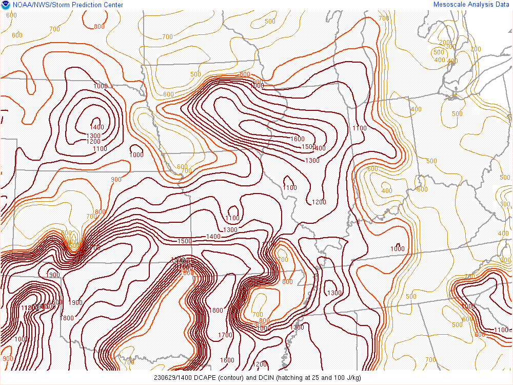
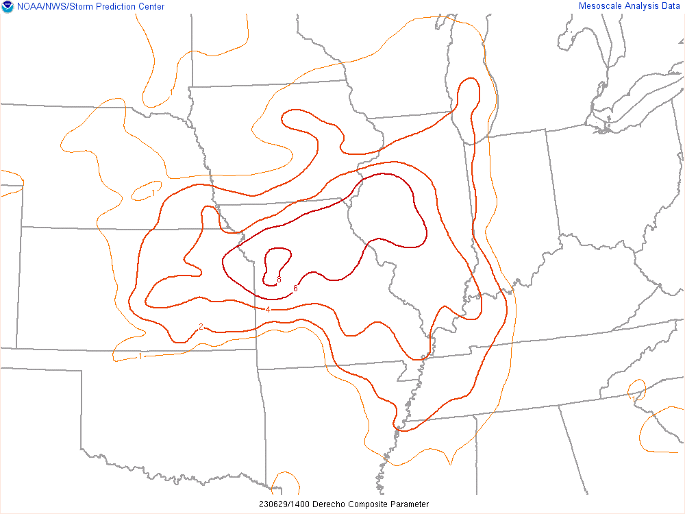
Environment
 |
 |
 |
| MD 1334 | MD1336 | MD1339 |
 |
 |
 |
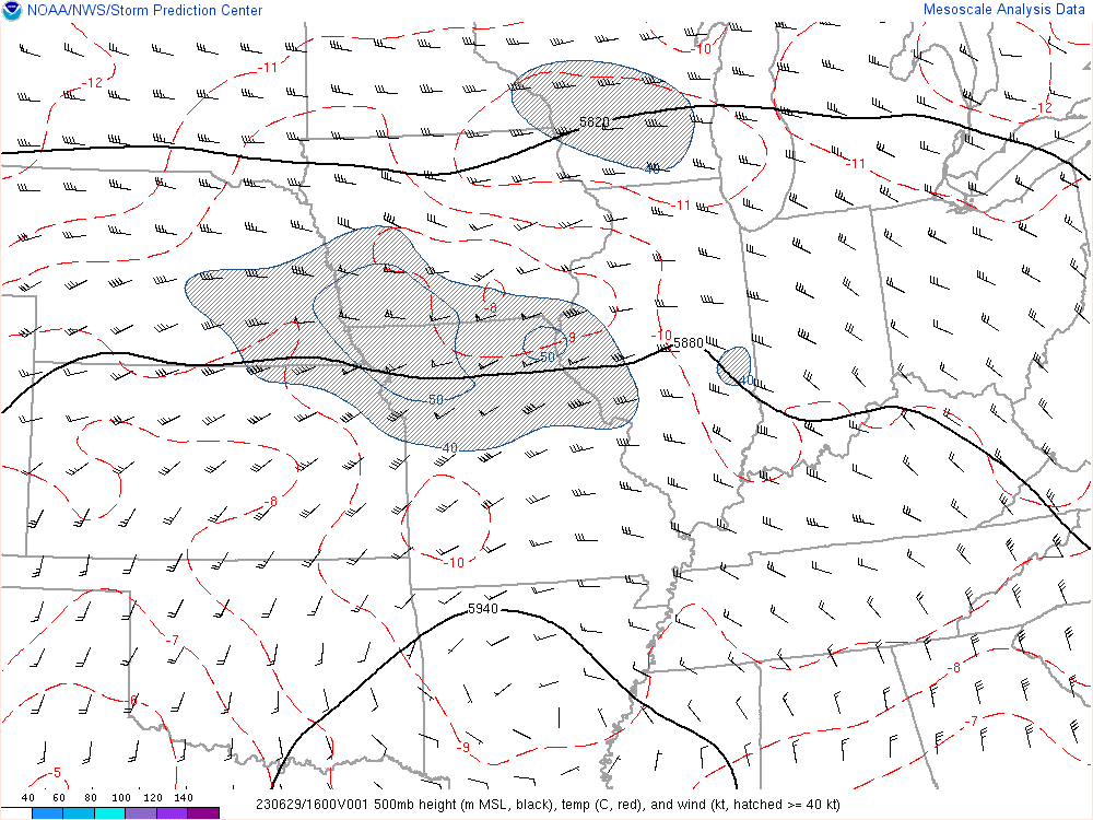 |
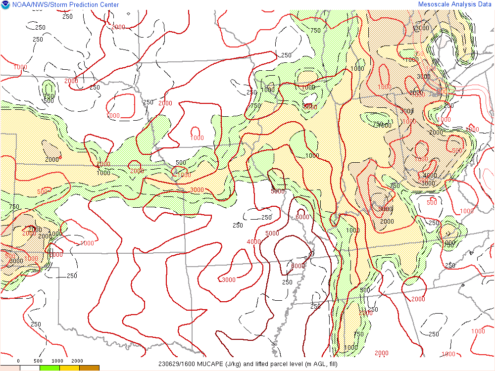
| SPC Mesoanalysis Downdraft CAPE | SPC Mesoanalysis Derecho Composite Parameter | SPC Mesoanalysis Most Unstable CAPE | SPC Mesoanalysis 500 hPa Analysis |
 |
 |
 |
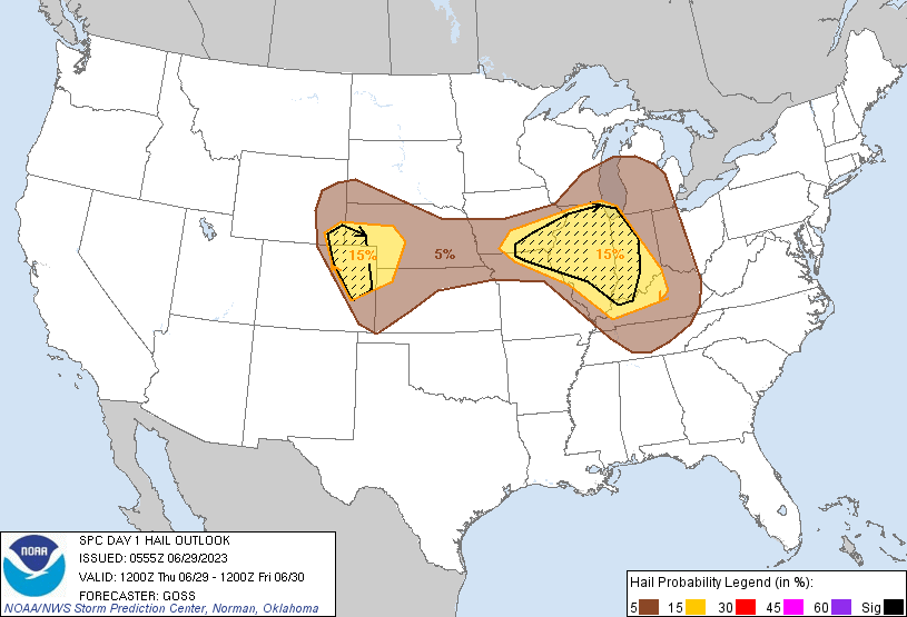 |
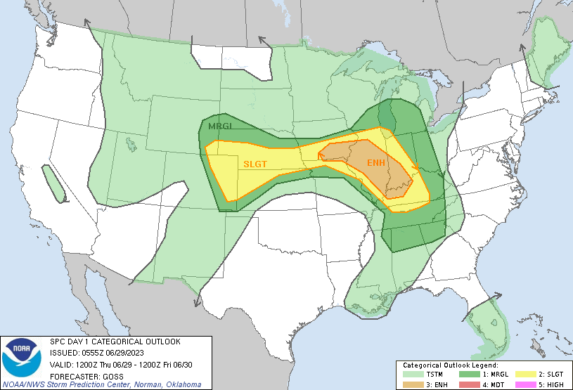
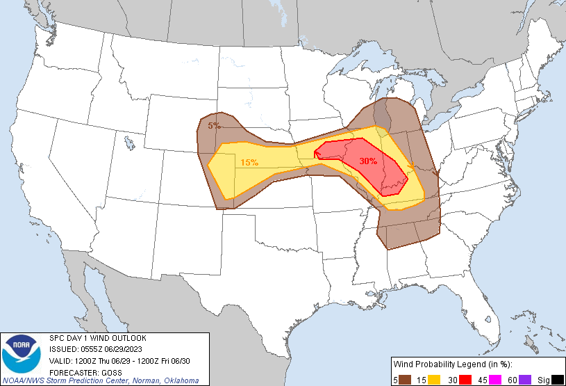
| SPC Severe Outlook | SPC Tornado Outlook | SPC Damaging Wind Outlook | SPC Large Hail Outlook |
Pictures of Event
If you have pictures you would like to share with us, please send them to us on our Facebook, Twitter or our Webmaster Email!
|
|||
 |
Media use of NWS Web News Stories is encouraged! Please acknowledge the NWS as the source of any news information accessed from this site. |
 |