|
|
 |
||
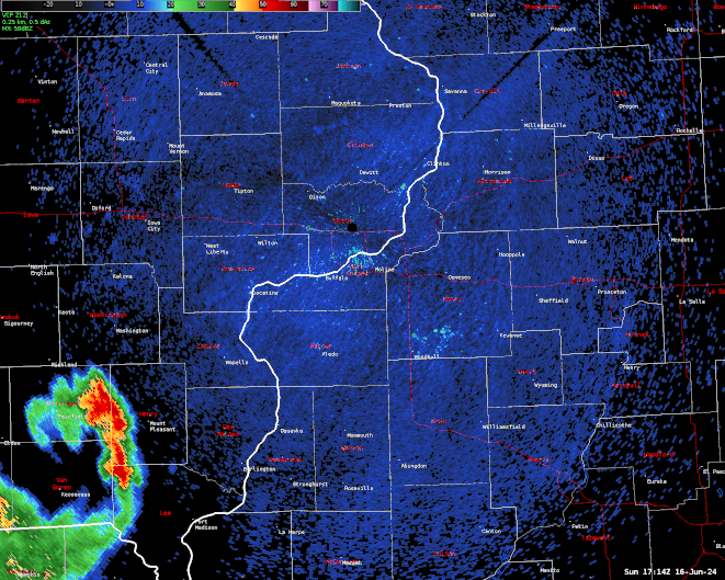
| Radar Loop from 11:15 AM - 4:30 P.M. (IEM Radar Loop) |
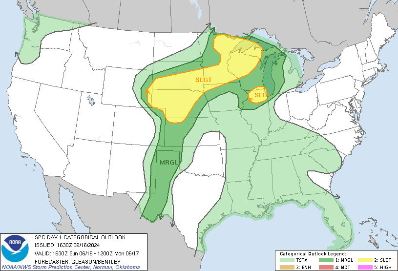
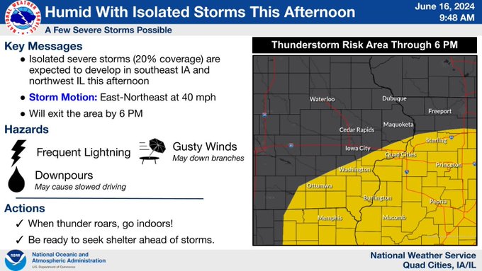
| Forecast Services Leading Up to Event | |||
 |
 |
 |
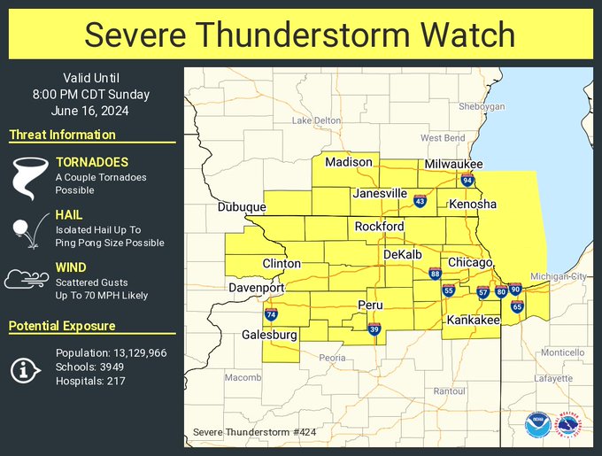 |
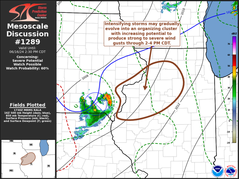
| SPC Day 1 Outlook: 1130 A.M. | NWS Quad Cities Graphicast | Mesoscale Convective Discussion #1289 | Severe Thunderstorm Watch #424 |
Also see this recap for north central and northeast Illinois from NWS Chicago.
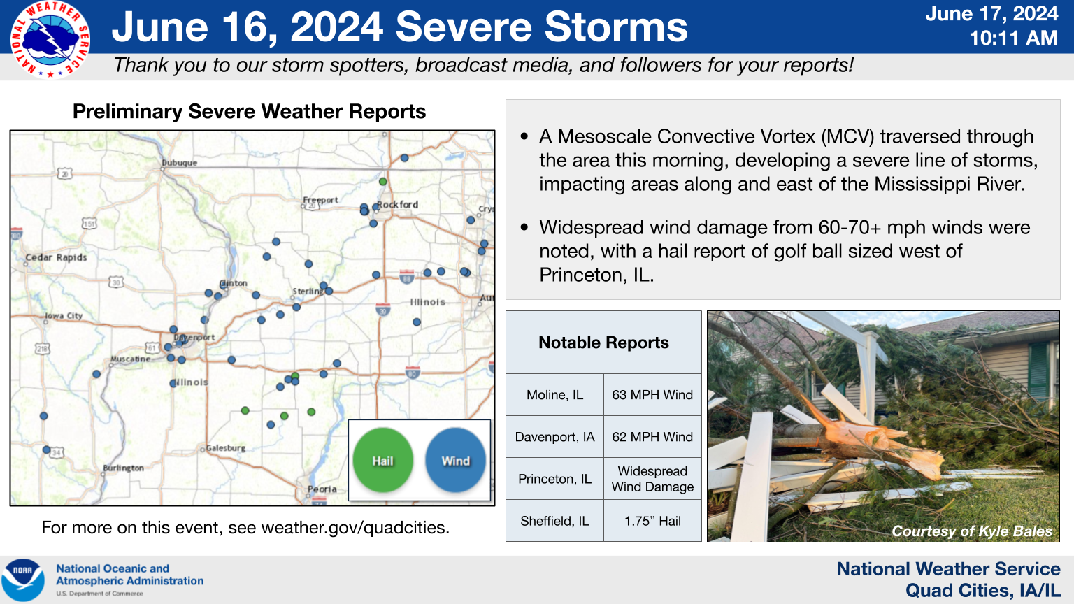
Storm Reports...Summary
Preliminary Local Storm Report...Summary
National Weather Service Quad Cities IA IL

..TIME...   ...EVENT...      ...CITY LOCATION...     ...LAT.LON...
..DATE...   ....MAG....      ..COUNTY LOCATION..ST.. ...SOURCE....
            ..REMARKS..
1230 PM     Tstm Wnd Gst     1 NNE Olds              41.14N 91.54W
06/16/2024  E50 MPH          Henry              IA   Trained Spotter


1235 PM     Tstm Wnd Gst     Mount Pleasant Municipa 40.95N 91.52W
06/16/2024  M46 MPH          Henry              IA   AWOS

            AWOS station KMPZ Mount Pleasant Arpt.

0115 PM     Tstm Wnd Gst     Muscatine Municipality  41.37N 91.15W
06/16/2024  M49 MPH          Muscatine          IA   AWOS

            AWOS station KMUT Muscatine Arpt.

0148 PM     Tstm Wnd Dmg     1 N Credit Island       41.52N 90.62W
06/16/2024                   Scott              IA   Trained Spotter

            12inch limb blown off of tree in backyard
            from earlier storm today.

0148 PM     Tstm Wnd Dmg     4 ESE Davenport         41.54N 90.54W
06/16/2024                   Scott              IA   NWS Employee

            Large branches down across road. Powerlines
            were down as well due to tree limbs.

0150 PM     Tstm Wnd Gst     1 SSW Rock Island       41.46N 90.60W
06/16/2024  E50 MPH          Rock Island        IL   Trained Spotter


0152 PM     Tstm Wnd Gst     Davenport Municipality  41.62N 90.58W
06/16/2024  M62 MPH          Scott              IA   ASOS

            ASOS station KDVN Davenport Arpt.

0153 PM     Tstm Wnd Gst     2 WNW Bettendorf        41.57N 90.51W
06/16/2024  E55 MPH          Scott              IA   Trained Spotter


0154 PM     Tstm Wnd Gst     1 W Moline Quad-City Ai 41.45N 90.52W
06/16/2024  M63 MPH          Rock Island        IL   ASOS

            Corrects previous tstm wnd gst report from 1
            W Moline Quad-City Airport. Corrects
            previous tstm wnd gst report from 1 W Moline
            Quad-City Airport. ASOS station KMLI Quad
            City Intl Arpt.

0156 PM     Tstm Wnd Dmg     Preemption              41.32N 90.58W
06/16/2024                   Mercer             IL   Amateur Radio

            Social media post of powerlines down closing
            Highway 67 in both directions.

0158 PM     Tstm Wnd Gst     1 WSW Bettendorf        41.56N 90.50W
06/16/2024  E60 MPH          Scott              IA   NWS Employee


0204 PM     Tstm Wnd Dmg     1 ENE Princeton         41.67N 90.35W
06/16/2024                   Scott              IA   Broadcast Media

            Pine tree snapped onto house at this
            location. Time based on radar.

0217 PM     Tstm Wnd Gst     1 SE Clinton Municipali 41.82N 90.32W
06/16/2024  M54 MPH          Clinton            IA   AWOS

            AWOS station KCWI Clinton Arpt.

0218 PM     Tstm Wnd Dmg     2 E Camanche            41.80N 90.25W
06/16/2024                   Clinton            IA   NWS Employee

            6 to 8 inch diameter branch down at
            location.

0225 PM     Tstm Wnd Gst     2 NE Clinton            41.86N 90.21W
06/16/2024  M50 MPH          Clinton            IA   Trained Spotter


0231 PM     Tstm Wnd Dmg     Geneseo                 41.45N 90.15W
06/16/2024                   Henry              IL   Trained Spotter

            6 inch tree branch down by Hammond-Henry
            Hospital.

0236 PM     Tstm Wnd Dmg     Morrison                41.81N 89.97W
06/16/2024                   Whiteside          IL   Public

            Powerlines down from storms.

0240 PM     Hail             1 W Galva               41.17N 90.05W
06/16/2024  M0.25 Inch       Henry              IL   Emergency Mngr


0241 PM     Tstm Wnd Gst     Prophetstown            41.67N 89.93W
06/16/2024  E55 MPH          Whiteside          IL   Trained Spotter


0250 PM     Tstm Wnd Dmg     Chadwick                42.02N 89.89W
06/16/2024                   Carroll            IL   911 Call Center

            County dispatch reported tree fell on a
            squad car in town of Chadwick. Time
            estimated by radar.

0256 PM     Tstm Wnd Dmg     Lanark                  42.10N 89.82W
06/16/2024                   Carroll            IL   911 Call Center

            County dispatch reported tree down in
            Lanark. Time estimated by radar.

0300 PM     Tstm Wnd Gst     Whiteside County Airpor 41.74N 89.67W
06/16/2024  M49 MPH          Whiteside          IL   AWOS

            AWOS station KSQI Sterling Rock Falls
            Airport.

0300 PM     Tstm Wnd Gst     5 N Tampico             41.70N 89.79W
06/16/2024  M43 MPH          Whiteside          IL   Trained Spotter

            Time estimated by radar.

0306 PM     Tstm Wnd Dmg     Neponset                41.30N 89.79W
06/16/2024                   Bureau             IL   Broadcast Media

            Large branches down in town.

0315 PM     Tstm Wnd Dmg     1 SSE Sheffield         41.34N 89.73W
06/16/2024                   Bureau             IL   Broadcast Media

            Photos relayed of a few trees snapped near
            the base at the Hidden Lake Country Club
            south of Sheffield. One tree branch landed
            on the side of a building causing damage.

0317 PM     Tstm Wnd Dmg     Buda                    41.33N 89.68W
06/16/2024                   Bureau             IL   Broadcast Media

            Tree damage reported in town.

0318 PM     Hail             3 N Buda                41.36N 89.68W
06/16/2024  E1.75 Inch       Bureau             IL   Public

            Time estimated by radar.

0335 PM     Tstm Wnd Dmg     Princeton               41.37N 89.47W
06/16/2024                   Bureau             IL   Broadcast Media

            Reports of trees down in Princeton. Time
            based on radar.

0340 PM     Tstm Wnd Dmg     Malden                  41.43N 89.37W
06/16/2024                   Bureau             IL   Broadcast Media

            Media reported trees down in Malden.

0408 PM     Hail             3 SSE Milo              41.16N 89.56W
06/16/2024  M0.75 Inch       Bureau             IL   Trained Spotter

            One inch diameter branches down too.
Media use of NWS Web News Stories is encouraged!
Please acknowledge the NWS as the source of any news information accessed from this site.
Our past events page can be found at weather.gov/dvn/events.