|
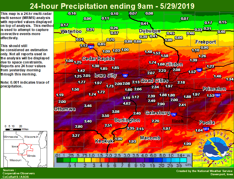
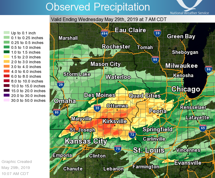
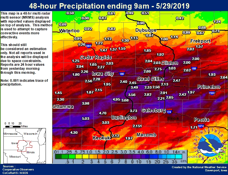
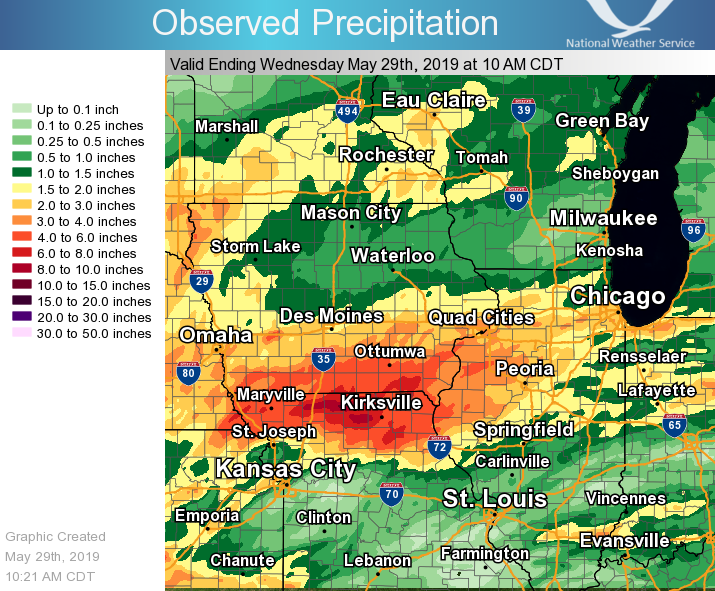
A frontal boundary settled across northern Kansas, northern Missouri and central Illinois. This front was the focus area for the development of several rounds of showers and thunderstorms that impacted the region today. The first round came through during the morning, and produced mainly torrential rainfall, small hail, brief wind gusts and frequent lightning. The second round of showers and thunderstorms developed and passed across the region during the late afternoon and evening. A segment of thunderstorms became severe along and south of Highway 34, and produced damaging wind gusts near 70 MPH. This lead to several reports of wind damage from Burlington eastward to Roseville. Additionally, prolonged torrential rainfall over already saturated grounds lead to numerous reports of flash flooding across the area.
|
|
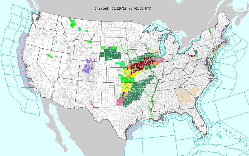
| Interactive Storm Report Map | SPC Storm Reports |
 |
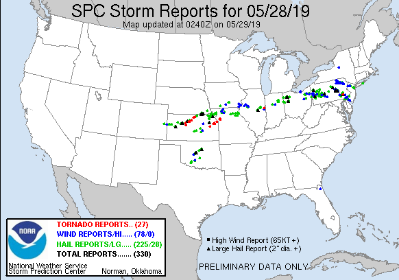 |
PRELIMINARY LOCAL STORM REPORT...SUMMARY
NATIONAL WEATHER SERVICE QUAD CITIES IA IL
949 AM CDT WED MAY 29 2019
..TIME... ...EVENT... ...CITY LOCATION... ...LAT.LON...
..DATE... ....MAG.... ..COUNTY LOCATION..ST.. ...SOURCE....
..REMARKS..
0614 PM FLASH FLOOD BATAVIA 41.00N 92.17W
05/28/2019 JEFFERSON IA PUBLIC
PUBLIC SENT US PICTURES OF WATER OUT OF THE
BANKS OF A CREEK IN BATAVIA RUNNING DOWN
AREA ROADS.
0730 PM FLASH FLOOD FARMINGTON 40.64N 91.75W
05/28/2019 VAN BUREN IA TRAINED SPOTTER
SPOTTER REPORTED WATER QUICKLY FLOWING OVER
HIGHWAY 2 IN FARMINGTON.
0741 PM FLASH FLOOD MOLINE 41.49N 90.49W
05/28/2019 ROCK ISLAND IL BROADCAST MEDIA
FLASH FLOODING ON RIVER DRIVE BY THE
TAXSLAYER CENTER. VIA FACEBOOK LIVE.
0747 PM FLASH FLOOD 1 NE BEAVERDALE 40.87N 91.20W
05/28/2019 DES MOINES IA EMERGENCY MNGR
RELAYED INFORMATION FROM TRAINED SPOTTERS
REPORTING WATER OVER FLINT BOTTOM RD
AFFECTING FLINT CREEK BRIDGE.
0754 PM FLASH FLOOD 2 WSW CORALVILLE 41.68N 91.64W
05/28/2019 JOHNSON IA MESONET
IFC GAUGE FOR DEER CREEK IN IOWA CITY ROSE
TO MODERATE FLOOD STAGE IN HEAVY RAIN.
0800 PM FLASH FLOOD 1 SE OXFORD 41.71N 91.78W
05/28/2019 JOHNSON IA MESONET
IFC RIVER GAUGE ALONG CLEAR CREEK ON
CHAMBERS AVE NW RISING ABOVE MINOR FLOOD
STAGE DUE TO HEAVY RAIN.
0802 PM FLASH FLOOD 4 SSE PARNELL 41.53N 91.99W
05/28/2019 IOWA IA MESONET
IFC RIVER GAUGE ALONG NORTH ENGLISH RIVER
OWEST OF Q AVENUE RISING ABOVE FLOOD STAGE
DUE TO HEAVY RAIN.
0803 PM FLASH FLOOD 3 NE KINROSS 41.49N 91.94W
05/28/2019 WASHINGTON IA MESONET
IFC RIVER GAUGE ALONG SOUTH ENGLISH RIVER
EAST OF 338TH AVE RISING ABOVE FLOOD STAGE
DUE TO HEAVY RAIN.
0830 PM FLASH FLOOD MACOMB 40.47N 90.68W
05/28/2019 MCDONOUGH IL PUBLIC
BROADCAST MEDIA SHARED A PUBLIC VIDEO
SHOWING WIDESPREAD FLASH FLOODING IN THE
CITY OF MACOMB.
0830 PM FLASH FLOOD 1 SW MACOMB 40.46N 90.70W
05/28/2019 MCDONOUGH IL 911 CALL CENTER
HIGHWAY 136 NEAR MACOMB TEMPORARILY CLOSED
WITH OVER 2 FEET OF WATER.
0430 PM HAIL MILTON 40.67N 92.16W
05/28/2019 M0.75 INCH VAN BUREN IA TRAINED SPOTTER
0504 PM HAIL 3 W MOUNT STERLING 40.62N 92.00W
05/28/2019 E0.25 INCH VAN BUREN IA TRAINED SPOTTER
ALSO TORRENTIAL RAINFALL. VISIBILITY LESS
THAN 1/10TH MILE AT TIMES.
0550 PM HAIL MOUNT PLEASANT 40.97N 91.55W
05/28/2019 M0.70 INCH HENRY IA TRAINED SPOTTER
0557 PM HAIL 1 NW MOUNT PLEASANT 40.97N 91.56W
05/28/2019 M0.25 INCH HENRY IA TRAINED SPOTTER
0658 PM HAIL 3 SSW NEW LONDON 40.89N 91.43W
05/28/2019 E0.75 INCH HENRY IA TRAINED SPOTTER
VERY HEAVY RAIN ALSO.
0714 PM HAIL 2 W WEST BURLINGTON 40.83N 91.21W
05/28/2019 E0.88 INCH DES MOINES IA EMERGENCY MNGR
0747 PM TSTM WND DMG ROSEVILLE 40.73N 90.66W
05/28/2019 WARREN IL PUBLIC
REPORT OF POWER LINES DOWN IN ROSEVILLE.
TIME OF THE EVENT WAS ESTIMATED USING RADAR.
0654 PM TSTM WND GST N NEW LONDON 40.95N 91.41W
05/28/2019 E60 MPH HENRY IA TRAINED SPOTTER
TRAINED SPOTTER ESTIMATED WIND SPEEDS OF 50
TO 60 MPH.
0707 PM TSTM WND GST MIDDLETOWN 40.83N 91.27W
05/28/2019 E50 MPH DES MOINES IA TRAINED SPOTTER
ALSO PEA SIZED HAIL.
0708 PM TSTM WND GST FRANKLIN 40.67N 91.51W
05/28/2019 E60 MPH LEE IA TRAINED SPOTTER
ALSO PEA HAIL AND VERY HEAVY RAIN.
0714 PM TSTM WND GST BURLINGTON 40.81N 91.12W
05/28/2019 E55 MPH DES MOINES IA TRAINED SPOTTER
WINDS OVER 50 MPH.
0714 PM TSTM WND GST 2 W WEST BURLINGTON 40.83N 91.21W
05/28/2019 E65 MPH DES MOINES IA EMERGENCY MNGR
WINDS AT LEAST 65 MPH WITH ZERO VISIBILITY.
0715 PM TSTM WND GST 1 WSW BURLINGTON 40.80N 91.14W
05/28/2019 E50 MPH DES MOINES IA TRAINED SPOTTER
WINDS POSSIBLY GREATER THAN 50 MPH. PEA HAIL
AND VERY HEAVY RAIN.
0719 PM TSTM WND GST 1 S BURLINGTON REGIONAL 40.77N 91.13W
05/28/2019 M68 MPH DES MOINES IA ASOS
ASOS STATION KBRL BURLINGTON ARPT.
0500 AM HEAVY RAIN 1 ESE BURLINGTON REGION 40.77N 91.12W
05/29/2019 M2.41 INCH DES MOINES IA CO-OP OBSERVER
CO-OP OBSERVER STATION BLGI4 BURLINGTON 2S.
0530 AM HEAVY RAIN 2 SSE DAVENPORT 41.53N 90.59W
05/29/2019 M2.13 INCH SCOTT IA COCORAHS
COCORAHS STATION IA-ST-4 DAVENPORT 0.9 SSW.
0700 AM HEAVY RAIN ALEXIS 41.06N 90.57W
05/29/2019 M2.90 INCH WARREN IL CO-OP OBSERVER
CO-OP OBSERVER STATION ALXI2 ALEXIS.
0700 AM HEAVY RAIN 2 WSW BETTENDORF 41.55N 90.51W
05/29/2019 M2.00 INCH SCOTT IA COCORAHS
COCORAHS STATION IA-ST-28 BETTENDORF 1.6
WSW.
0700 AM HEAVY RAIN CAMANCHE 41.80N 90.28W
05/29/2019 M2.08 INCH CLINTON IA COCORAHS
COCORAHS STATION IA-CN-5 CAMANCHE 1.2 W.
0700 AM HEAVY RAIN 1 SSE CANTRIL 40.63N 92.06W
05/29/2019 M2.80 INCH VAN BUREN IA COCORAHS
COCORAHS STATION IA-VB-11 CANTRIL 0.9 SSE.
0700 AM HEAVY RAIN 4 NW ELIZA 41.34N 91.01W
05/29/2019 M2.66 INCH ROCK ISLAND IL COCORAHS
COCORAHS STATION IL-RI-22 ILLINOIS CITY 6.7
SW.
0700 AM HEAVY RAIN 2 NNW WILLIAMSTOWN 41.59N 91.75W
05/29/2019 M2.00 INCH JOHNSON IA COCORAHS
COCORAHS STATION IA-JH-9 KALONA 7.3 NNW.
0700 AM HEAVY RAIN 2 N MUSCATINE 41.45N 91.07W
05/29/2019 M2.08 INCH MUSCATINE IA COCORAHS
COCORAHS STATION IA-MC-13 MUSCATINE 2.1 N.
0700 AM HEAVY RAIN 1 SSE NAUVOO 40.54N 91.38W
05/29/2019 M2.21 INCH HANCOCK IL COCORAHS
COCORAHS STATION IL-HN-5 NAUVOO 0.7 SSE.
0700 AM HEAVY RAIN 1 SW NEW LONDON 40.91N 91.43W
05/29/2019 M3.08 INCH HENRY IA COCORAHS
COCORAHS STATION IA-HY-1 NEW LONDON 1.5 SW.
0700 AM HEAVY RAIN WAPELLO 41.17N 91.19W
05/29/2019 M3.19 INCH LOUISA IA COCORAHS
COCORAHS STATION IA-LS-3 WAPELLO 0.2 S.
0700 AM HEAVY RAIN 3 ESE AMBER 41.11N 91.13W
05/29/2019 M2.87 INCH LOUISA IA COCORAHS
COCORAHS STATION IA-LS-5 WAPELLO 5.4 SE.
0700 AM HEAVY RAIN 1 NNW WEST LIBERTY 41.58N 91.27W
05/29/2019 M2.08 INCH MUSCATINE IA COCORAHS
COCORAHS STATION IA-MC-15 WEST LIBERTY 0.7
NNW.
0700 AM HEAVY RAIN WOODHULL 41.18N 90.32W
05/29/2019 M2.00 INCH HENRY IL COCORAHS
COCORAHS STATION IL-HY-11 WOODHULL 0.3 ESE.
0730 AM HEAVY RAIN MEMPHIS 40.46N 92.17W
05/29/2019 M3.45 INCH SCOTLAND MO COCORAHS
COCORAHS STATION MO-FSA-199 MEMPHIS 0.1 S.
0730 AM HEAVY RAIN 3 NNE MUSCATINE 41.45N 91.06W
05/29/2019 M2.14 INCH MUSCATINE IA COCORAHS
COCORAHS STATION IA-MC-6 MUSCATINE 2.6 NNE.
0800 AM HEAVY RAIN MONMOUTH 40.91N 90.65W
05/29/2019 M2.90 INCH WARREN IL COCORAHS
COCORAHS STATION IL-WR-5 , IL.
0800 AM HEAVY RAIN 1 NNW ALEDO 41.21N 90.75W
05/29/2019 M2.39 INCH MERCER IL COCORAHS
COCORAHS STATION IL-MR-7 ALEDO 0.7 NNW.
0800 AM HEAVY RAIN 1 S CORALVILLE 41.67N 91.60W
05/29/2019 M2.06 INCH JOHNSON IA COCORAHS
COCORAHS STATION IA-JH-20 CORALVILLE 1.4 S.
0830 AM HEAVY RAIN 2 NNE LE CLAIRE 41.62N 90.35W
05/29/2019 M2.02 INCH SCOTT IA COCORAHS
COCORAHS STATION IA-ST-1 LE CLAIRE 1.8 NNE.
0907 AM HEAVY RAIN 1 NE FARMINGTON 40.65N 91.72W
05/29/2019 M2.81 INCH VAN BUREN IA MESONET
MESONET STATION FRMI4 SHIMEK STATE FOREST.
0912 AM HEAVY RAIN 3 W PLEASANT GROVE 40.97N 91.34W
05/29/2019 M2.85 INCH DES MOINES IA MESONET
MESONET STATION CW3742 NEW LONDON.
0919 AM HEAVY RAIN 1 SW STRONGHURST 40.74N 90.91W
05/29/2019 M2.07 INCH HENDERSON IL MESONET
MESONET STATION CW6338 STRONGHURST.
0920 AM HEAVY RAIN 1 E MUSCATINE 41.42N 91.05W
05/29/2019 M2.48 INCH MUSCATINE IA MESONET
MESONET STATION FW3897 MUSCATINE.
0922 AM HEAVY RAIN 3 E IOWA CITY 41.65N 91.48W
05/29/2019 M1.96 INCH JOHNSON IA MESONET
MESONET STATION CW5749 IOWA CITY.
0634 AM FLOOD 3 W MOUNT STERLING 40.62N 92.00W
05/29/2019 VAN BUREN IA TRAINED SPOTTER
JERSEY AVE CLOSED BY FOX RIVER BRIDGE IN
EACH DIRECTION WITH APPROX 1-2 FT OF WATER.
FOX RIVER WELL OUT OF ITS BANKS.
1044 AM HAIL WILTON 41.59N 91.02W
05/28/2019 E0.25 INCH MUSCATINE IA TRAINED SPOTTER
.
0940 PM HEAVY RAIN BONAPARTE 40.70N 91.80W
05/28/2019 M3.00 INCH VAN BUREN IA TRAINED SPOTTER
TOTAL RAINFALL THIS EVENING AS OF 940 PM.
1204 AM HEAVY RAIN WEST BURLINGTON 40.83N 91.15W
05/29/2019 M2.60 INCH DES MOINES IA TRAINED SPOTTER
RAIN TOTAL FROM THIS EVENING, BUT STILL
RAINING.
1218 AM HEAVY RAIN 2 N KALONA 41.51N 91.71W
05/29/2019 M3.04 INCH JOHNSON IA TRAINED SPOTTER
RAINFALL SINCE TUESDAY MORNING.
0500 AM HEAVY RAIN 2 NW GENESEO 41.47N 90.18W
05/29/2019 M2.18 INCH HENRY IL COCORAHS
COCORAHS STATION IL-HY-8 GENESEO 2.0 NW.
0515 AM HEAVY RAIN WAYLAND 40.39N 91.58W
05/29/2019 M2.45 INCH CLARK MO TRAINED SPOTTER
RAINFALL TOTAL YESTERDAY.
0516 AM HEAVY RAIN DURANT 41.60N 90.91W
05/29/2019 M2.25 INCH CEDAR IA TRAINED SPOTTER
EVENT TOTAL SINCE 10 AM TUESDAY.
0553 AM HEAVY RAIN PARNELL 41.58N 92.01W
05/29/2019 M2.05 INCH IOWA IA TRAINED SPOTTER
0559 AM HEAVY RAIN 1 NW DAVENPORT 41.56N 90.62W
05/29/2019 E2.44 INCH SCOTT IA TRAINED SPOTTER
0600 AM HEAVY RAIN 2 NE COLUSA 40.59N 91.15W
05/29/2019 M2.35 INCH HANCOCK IL TRAINED SPOTTER
0600 AM HEAVY RAIN 1 SE DAVENPORT 41.54N 90.59W
05/29/2019 M2.27 INCH SCOTT IA COCORAHS
COCORAHS STATION IA-ST-37 DAVENPORT 0.9 WNW.
0600 AM HEAVY RAIN 1 WSW MEMPHIS 40.46N 92.18W
05/29/2019 M3.27 INCH SCOTLAND MO CO-OP OBSERVER
CO-OP OBSERVER STATION MMPM7 MEMPHIS.
0600 AM HEAVY RAIN 2 S PRAIRIE CITY 40.59N 90.46W
05/29/2019 M1.97 INCH MCDONOUGH IL CO-OP OBSERVER
CO-OP OBSERVER STATION PRCI2 PRAIRIE CITY.
0600 AM HEAVY RAIN 3 W RICHMOND 41.46N 91.76W
05/29/2019 M1.97 INCH WASHINGTON IA COCORAHS
COCORAHS STATION IA-WS-7 WELLMAN 4.0 E.
0606 AM HEAVY RAIN 1 SE DAVENPORT 41.54N 90.59W
05/29/2019 M2.27 INCH SCOTT IA TRAINED SPOTTER
0614 AM HEAVY RAIN 2 NNE CREDIT ISLAND 41.52N 90.60W
05/29/2019 M2.22 INCH SCOTT IA TRAINED SPOTTER
0627 AM HEAVY RAIN 3 ENE CHARLIE HEATH MEM 40.61N 91.84W
05/29/2019 M2.90 INCH CLARK MO TRAINED SPOTTER
EVENT TOTAL.
0630 AM HEAVY RAIN 1 ENE RIVERDALE 41.54N 90.45W
05/29/2019 M2.23 INCH SCOTT IA COCORAHS
COCORAHS STATION IA-ST-8 BETTENDORF 2.2 SE.
0639 AM HEAVY RAIN 1 NE FORT MADISON 40.64N 91.33W
05/29/2019 M2.30 INCH LEE IA TRAINED SPOTTER
24-HR TOTAL.
0639 AM HEAVY RAIN 3 W MOUNT STERLING 40.62N 92.00W
05/29/2019 M3.20 INCH VAN BUREN IA TRAINED SPOTTER
SINCE 5 PM LAST EVENING.
0643 AM HEAVY RAIN COLUMBUS JUNCTION 41.28N 91.37W
05/29/2019 M1.90 INCH LOUISA IA TRAINED SPOTTER
0650 AM HEAVY RAIN 1 E REYNOLDS 41.34N 90.65W
05/29/2019 M2.09 INCH ROCK ISLAND IL COCORAHS
COCORAHS STATION IL-RI-17 MILAN 8.8 SSW.
0700 AM HEAVY RAIN ALEDO 41.20N 90.75W
05/29/2019 M2.49 INCH MERCER IL CO-OP OBSERVER
CO-OP OBSERVER STATION ALEI2 ALEDO.
0700 AM HEAVY RAIN DONNELLSON 40.65N 91.56W
05/29/2019 M2.51 INCH LEE IA CO-OP OBSERVER
CO-OP OBSERVER STATION DNNI4 DONNELLSON.
0700 AM HEAVY RAIN 1 NW ELDRIDGE 41.65N 90.59W
05/29/2019 M2.09 INCH SCOTT IA COCORAHS
COCORAHS STATION IA-ST-21 ELDRIDGE 0.6 S.
0700 AM HEAVY RAIN 1 WNW MOLINE 41.49N 90.51W
05/29/2019 M2.34 INCH ROCK ISLAND IL COCORAHS
COCORAHS STATION IL-RI-18 MOLINE 1.0 WNW.
0700 AM HEAVY RAIN 4 NNE MUSCATINE 41.47N 91.05W
05/29/2019 M2.13 INCH MUSCATINE IA CO-OP OBSERVER
CO-OP OBSERVER STATION MSTI4 2 N MUSCATINE.
0700 AM HEAVY RAIN 3 SSW NICHOLS 41.44N 91.33W
05/29/2019 M2.09 INCH MUSCATINE IA COCORAHS
COCORAHS STATION IA-MC-11 NICHOLS 3.2 SSW.
0700 AM HEAVY RAIN PARK VIEW 41.69N 90.54W
05/29/2019 M2.23 INCH SCOTT IA COCORAHS
COCORAHS STATION IA-ST-3 PARK VIEW 0.2 WSW.
0700 AM HEAVY RAIN 1 N RIVERDALE 41.54N 90.47W
05/29/2019 M2.20 INCH SCOTT IA COCORAHS
COCORAHS STATION IA-ST-42 RIVERDALE 0.5 N.
0700 AM HEAVY RAIN 1 WNW ROSEVILLE 40.73N 90.67W
05/29/2019 M2.20 INCH WARREN IL COCORAHS
COCORAHS STATION IL-WR-2 ROSEVILLE 0.6 WNW.
0700 AM HEAVY RAIN 1 ESE OASIS 41.70N 91.37W
05/29/2019 M2.44 INCH JOHNSON IA COCORAHS
COCORAHS STATION IA-CD-7 WEST BRANCH 2.0
NNW.
0700 AM HEAVY RAIN 2 SE WILLIAMSBURG 41.64N 91.98W
05/29/2019 M2.05 INCH IOWA IA CO-OP OBSERVER
CO-OP OBSERVER STATION WLBI4 1 E
WILLIAMSBURG.
0700 AM HEAVY RAIN 2 SW YARMOUTH 41.01N 91.35W
05/29/2019 M4.10 INCH DES MOINES IA TRAINED SPOTTER
0702 AM HEAVY RAIN 1 SSE BURLINGTON 40.80N 91.11W
05/29/2019 M2.59 INCH DES MOINES IA COCORAHS
COCORAHS STATION IA-DM-8 BURLINGTON 0.8 SSE.
0716 AM HEAVY RAIN 3 W MOUNT STERLING 40.62N 92.00W
05/29/2019 M4.10 INCH VAN BUREN IA TRAINED SPOTTER
0717 AM HEAVY RAIN FARMINGTON 40.63N 91.74W
05/29/2019 E3.25 INCH VAN BUREN IA TRAINED SPOTTER
24-HR TOTAL.
0731 AM HEAVY RAIN 2 NNW OAKLAND MILLS 40.97N 91.63W
05/29/2019 M3.30 INCH HENRY IA TRAINED SPOTTER
STORM TOTAL.
0800 AM HEAVY RAIN 1 NW ELDRIDGE 41.64N 90.59W
05/29/2019 M2.07 INCH SCOTT IA COCORAHS
COCORAHS STATION IA-ST-30 ELDRIDGE 0.7 SSW.
0800 AM HEAVY RAIN 2 E MORNING SUN 41.10N 91.22W
05/29/2019 M4.62 INCH LOUISA IA COCORAHS
COCORAHS STATION IA-LS-2 MORNING SUN 1.7 E.
0815 AM HEAVY RAIN 1 SE FAIRFIELD MUNICIPA 41.03N 91.97W
05/29/2019 M1.93 INCH JEFFERSON IA AWOS
AWOS STATION KFFL FAIRFIELD ARPT.
0824 AM HEAVY RAIN 1 SE KILWINNING 40.50N 92.33W
05/29/2019 M4.30 INCH SCOTLAND MO PUBLIC
24-HR TOTAL, SEVERAL COUNTY ROADS CLOSED
THROUGHOUT COUNTY. 5.60 INCHES IN PAST 48
HOURS.
0825 AM HEAVY RAIN 1 E MUSCATINE 41.42N 91.05W
05/29/2019 M2.48 INCH MUSCATINE IA MESONET
MESONET STATION FW3897 MUSCATINE.
0829 AM HEAVY RAIN 1 SW STRONGHURST 40.74N 90.91W
05/29/2019 M2.07 INCH HENDERSON IL MESONET
MESONET STATION CW6338 STRONGHURST.
0810 PM TSTM WND DMG BUSHNELL 40.55N 90.51W
05/28/2019 MCDONOUGH IL TRAINED SPOTTER
SIX INCH DIAMETER TREE LIMBS BROKEN AND
TREES DOWN.
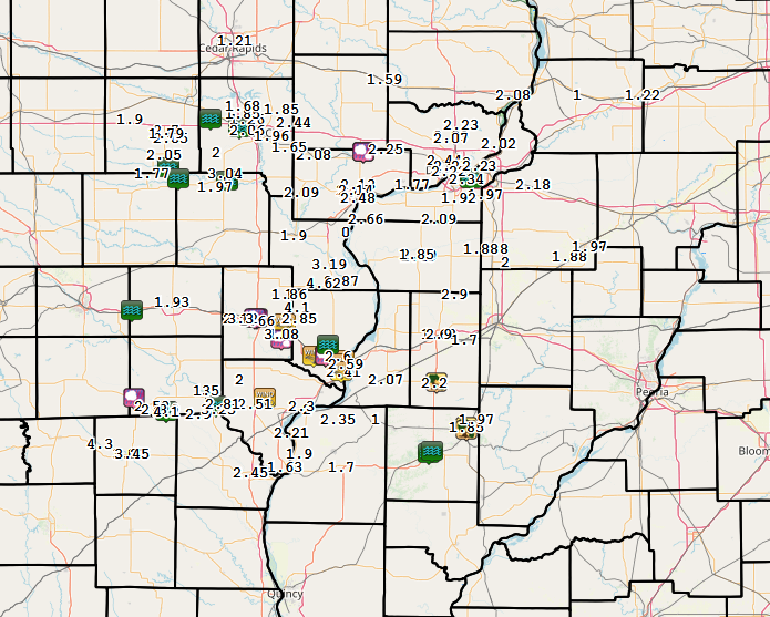
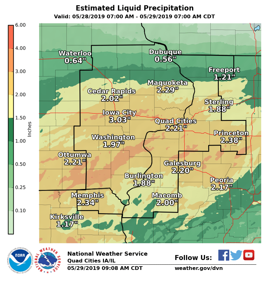
| Radar Estimated Rainfall | 24-Hour Local Rain Map | 24-Hour Regional Rain Map |
 |
 |
 |
| 48-Hour Local Rain Map | 7 Day Regional Rainfall | |
 |
 |
|
PUBLIC INFORMATION STATEMENT NATIONAL WEATHER SERVICE QUAD CITIES IA IL 935 AM CDT WED MAY 29 2019 ...HIGHEST 24-HR PRECIPITATION REPORTS... OBSERVATIONS ARE COLLECTED FROM A VARIETY OF SOURCES WITH VARYING EQUIPMENT AND EXPOSURES. WE THANK ALL VOLUNTEER WEATHER OBSERVERS FOR THEIR DEDICATION. NOT ALL DATA LISTED ARE CONSIDERED OFFICIAL. LOCATION AMOUNT TIME/DATE LAT/LON MORNING SUN 1.7 E 4.62 IN 0800 AM 05/29 41.10N/91.22W MEMPHIS 0.1 S 3.45 IN 0730 AM 05/29 40.46N/92.17W MEMPHIS 3.27 IN 0600 AM 05/29 40.46N/92.18W WAPELLO 0.2 S 3.19 IN 0700 AM 05/29 41.17N/91.19W NEW LONDON 1.5 SW 3.08 IN 0700 AM 05/29 40.91N/91.43W ALEXIS 2.90 IN 0700 AM 05/29 41.06N/90.57W MONMOUTH 2.90 IN 0800 AM 05/29 40.91N/90.65W WAPELLO 5.4 SE 2.87 IN 0700 AM 05/29 41.11N/91.13W NEW LONDON 2.85 IN 0912 AM 05/29 40.97N/91.34W SHIMEK STATE FOREST 2.81 IN 0907 AM 05/29 40.65N/91.72W CANTRIL 0.9 SSE 2.80 IN 0700 AM 05/29 40.63N/92.06W ILLINOIS CITY 6.7 SW 2.66 IN 0700 AM 05/29 41.34N/91.01W BURLINGTON 0.8 SSE 2.59 IN 0702 AM 05/29 40.80N/91.11W DONNELLSON 2.51 IN 0700 AM 05/29 40.65N/91.56W ALEDO 2.49 IN 0700 AM 05/29 41.20N/90.75W MUSCATINE 2.48 IN 0920 AM 05/29 41.42N/91.05W WEST BRANCH 2.0 NNW 2.44 IN 0700 AM 05/29 41.70N/91.37W BURLINGTON 2S 2.41 IN 0500 AM 05/29 40.77N/91.12W ALEDO 0.7 NNW 2.39 IN 0800 AM 05/29 41.21N/90.75W DALLAS CITY 3.0 SSE 2.35 IN 0600 AM 05/29 40.59N/91.15W MOLINE 1.0 WNW 2.34 IN 0700 AM 05/29 41.49N/90.51W DAVENPORT 0.9 WNW 2.27 IN 0600 AM 05/29 41.54N/90.59W PARK VIEW 0.2 WSW 2.23 IN 0700 AM 05/29 41.69N/90.54W BETTENDORF 2.2 SE 2.23 IN 0630 AM 05/29 41.54N/90.45W NAUVOO 0.7 SSE 2.21 IN 0700 AM 05/29 40.54N/91.38W RIVERDALE 0.5 N 2.20 IN 0700 AM 05/29 41.54N/90.47W ROSEVILLE 0.6 WNW 2.20 IN 0700 AM 05/29 40.73N/90.67W GENESEO 2.0 NW 2.18 IN 0500 AM 05/29 41.47N/90.18W MUSCATINE 2.6 NNE 2.14 IN 0730 AM 05/29 41.45N/91.06W DAVENPORT 0.9 SSW 2.13 IN 0530 AM 05/29 41.53N/90.59W 2 N MUSCATINE 2.13 IN 0700 AM 05/29 41.47N/91.05W NICHOLS 3.2 SSW 2.09 IN 0700 AM 05/29 41.44N/91.33W ELDRIDGE 0.6 S 2.09 IN 0700 AM 05/29 41.65N/90.59W MILAN 8.8 SSW 2.09 IN 0650 AM 05/29 41.34N/90.65W CAMANCHE 1.2 W 2.08 IN 0700 AM 05/29 41.80N/90.28W MUSCATINE 2.1 N 2.08 IN 0700 AM 05/29 41.45N/91.07W WEST LIBERTY 0.7 NNW 2.08 IN 0700 AM 05/29 41.58N/91.27W STRONGHURST 2.07 IN 0919 AM 05/29 40.74N/90.91W ELDRIDGE 0.7 SSW 2.07 IN 0800 AM 05/29 41.64N/90.59W CORALVILLE 1.4 S 2.06 IN 0800 AM 05/29 41.67N/91.60W 1 E WILLIAMSBURG 2.05 IN 0700 AM 05/29 41.64N/91.98W LE CLAIRE 1.8 NNE 2.02 IN 0830 AM 05/29 41.62N/90.35W KALONA 7.3 NNW 2.00 IN 0700 AM 05/29 41.59N/91.75W BETTENDORF 1.6 WSW 2.00 IN 0700 AM 05/29 41.55N/90.51W WOODHULL 0.3 ESE 2.00 IN 0700 AM 05/29 41.18N/90.32W WELLMAN 4.0 E 1.97 IN 0600 AM 05/29 41.46N/91.76W COAL VALLEY 1.9 SE 1.97 IN 0700 AM 05/29 41.43N/90.42W KEWANEE 1 E 1.97 IN 0700 AM 05/29 41.24N/89.90W PRAIRIE CITY 1.97 IN 0600 AM 05/29 40.59N/90.46W IOWA CITY 1.96 IN 0922 AM 05/29 41.65N/91.48W MILAN 1.92 IN 0923 AM 05/29 41.42N/90.55W GALVA 2.7 NE 1.88 IN 0600 AM 05/29 41.20N/90.00W NEW WINDSOR 2.0 N 1.88 IN 0700 AM 05/29 41.23N/90.44W ALEDO 1.85 IN 0916 AM 05/29 41.21N/90.76W IOWA CITY 8.0 NE 1.85 IN 0700 AM 05/29 41.75N/91.43W NORTH LIBERTY 0.7 SSW 1.85 IN 0800 AM 05/29 41.73N/91.62W MACOMB 1.85 IN 0700 AM 05/29 40.48N/90.67W ALPHA 2.3 N 1.80 IN 0700 AM 05/29 41.23N/90.37W WILLIAMSBURG 1.79 IN 0914 AM 05/29 41.66N/92.00W TIPTON 0.7 N 1.79 IN 0815 AM 05/29 41.78N/91.13W NORTH ENGLISH 1.77 IN 0700 AM 05/29 41.51N/92.07W CALAMUS 2.0 NE 1.74 IN 0700 AM 05/29 41.84N/90.73W WASHINGTON 5.8 SW 1.74 IN 0600 AM 05/29 41.24N/91.77W AINSWORTH 7.4 N 1.73 IN 0700 AM 05/29 41.40N/91.54W DE WITT 1.68 IN 0800 AM 05/29 41.81N/90.54W SOLON 0.3 ESE 1.61 IN 0700 AM 05/29 41.80N/91.49W MUSCATINE 1.4 N 1.60 IN 0700 AM 05/29 41.44N/91.07W KEOKUK MUNI 1.59 IN 0700 AM 05/29 40.47N/91.42W KEOKUK ARPT 1.59 IN 0915 AM 05/29 40.47N/91.42W CHARLOTTE 1.9 WNW 1.58 IN 0700 AM 05/29 41.98N/90.50W COLCHESTER 3.5 NE 1.56 IN 0700 AM 05/29 40.46N/90.75W MOUNT VERNON 0.7 ENE 1.54 IN 0606 AM 05/29 41.93N/91.41W TISKILWA 2.1 N 1.53 IN 0700 AM 05/29 41.32N/89.50W DELMAR 2.3 NW 1.52 IN 0700 AM 05/29 42.02N/90.64W PROPHETSTOWN 0.2 SW 1.52 IN 0700 AM 05/29 41.67N/89.94W MACOMB ARPT 1.50 IN 0915 AM 05/29 40.52N/90.65W SIGOURNEY 1.50 IN 0800 AM 05/29 41.33N/92.20W MAQUOKETA 1.48 IN 0700 AM 05/29 42.05N/90.75W GENESEO 1.47 IN 1200 AM 05/29 41.45N/90.15W WALNUT 5.3 ENE 1.46 IN 0700 AM 05/29 41.58N/89.50W MORRISON 3.2 E 1.45 IN 0700 AM 05/29 41.82N/89.90W OLIN 1.43 IN 0905 AM 05/29 42.02N/91.13W MARENGO 2.6 SSW 1.42 IN 0700 AM 05/29 41.76N/92.08W MORRISON 1.40 IN 0921 AM 05/29 41.82N/89.98W ELDRIDGE 1.39 IN 0917 AM 05/29 41.65N/90.59W COLETA 1.4 SSW 1.39 IN 0700 AM 05/29 41.89N/89.81W PRINCETON 1.1 SE 1.33 IN 0700 AM 05/29 41.37N/89.45W CEDAR RAPIDS 5.2 NNE 1.30 IN 0700 AM 05/29 42.04N/91.63W MILLEDGEVILLE 0.6 NW 1.26 IN 0700 AM 05/29 41.97N/89.78W PARNELL 0.1 SSW 1.25 IN 0530 AM 05/29 41.58N/92.01W MARENGO 3.6 N 1.25 IN 0700 AM 05/29 41.85N/92.06W MOUNT CARROLL 1.24 IN 0845 AM 05/29 42.10N/89.98W ROCK FALLS 3 NE 1.22 IN 0700 AM 05/29 41.80N/89.64W CEDAR RAPIDS 2.5 WSW 1.21 IN 0625 AM 05/29 41.95N/91.71W STERLING 1.19 IN 0925 AM 05/29 41.82N/89.67W CEDAR RAPIDS 2.7 NE 1.18 IN 0600 AM 05/29 42.00N/91.63W MORRISON 1.18 IN 0924 AM 05/29 41.80N/89.96W VINTON 1.12 IN 0700 AM 05/29 42.17N/92.01W FAIRFAX 4.0 NW 1.11 IN 0700 AM 05/29 41.96N/91.84W LANARK 1.6 SSE 1.10 IN 0700 AM 05/29 42.08N/89.82W MARION 1.7 NNW 1.09 IN 0607 AM 05/29 42.06N/91.61W MARION 1.04 IN 0920 AM 05/29 42.05N/91.57W BELLE PLAINE 1.00 IN 0700 AM 05/29 41.88N/92.28W VINTON 1.00 IN 0924 AM 05/29 42.15N/92.03W ANAMOSA 1.9 SE 1.00 IN 0456 AM 05/29 42.09N/91.25W MT. CARROLL 0.99 IN 0916 AM 05/29 42.09N/89.98W CENTER POINT 0.6 NNW 0.90 IN 0600 AM 05/29 42.19N/91.78W SHANNON 0.2 S 0.90 IN 0700 AM 05/29 42.15N/89.74W 2 ENE CEDAR RAPIDS 0.89 IN 0925 AM 05/29 42.00N/91.63W MONTICELLO 0.88 IN 0715 AM 05/29 42.24N/91.17W FAIRFIELD ARPT 0.87 IN 0915 AM 05/29 41.03N/91.97W CENTRAL CITY 6.7 W 0.85 IN 0515 AM 05/29 42.20N/91.65W PEARL CITY 0.4 SW 0.84 IN 0700 AM 05/29 42.26N/89.83W WASHINGTON ARPT 0.71 IN 0915 AM 05/29 41.27N/91.67W COGGON 0.70 IN 0600 AM 05/29 42.28N/91.53W CASCADE 0.68 IN 0700 AM 05/29 42.30N/91.00W FREEPORT 2.9 WSW 0.67 IN 0730 AM 05/29 42.27N/89.68W ELIZABETH 0.66 IN 0630 AM 05/29 42.32N/90.23W FREEPORT 1.7 ESE 0.65 IN 0700 AM 05/29 42.28N/89.60W RIDOTT 0.1 NE 0.64 IN 0613 AM 05/29 42.30N/89.48W FREEPORT 1.7 NW 0.63 IN 0650 AM 05/29 42.30N/89.66W MOUNT PLEASANT ARPT 0.63 IN 0915 AM 05/29 40.95N/91.52W CENTRAL CITY 0.62 IN 0924 AM 05/29 42.21N/91.52W FREEPORT 2.0 NW 0.61 IN 0700 AM 05/29 42.31N/89.66W FREEPORT ARPT 0.59 IN 0915 AM 05/29 42.25N/89.58W MOUNT AUBURN 2.2 NNW 0.51 IN 0600 AM 05/29 42.29N/92.11W |
||
SPC Convective Outlooks
 |
 |
 |
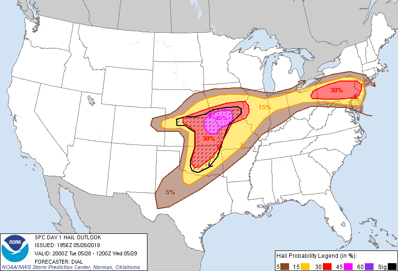 |
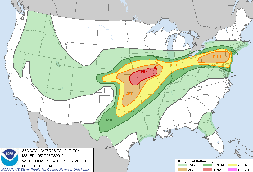
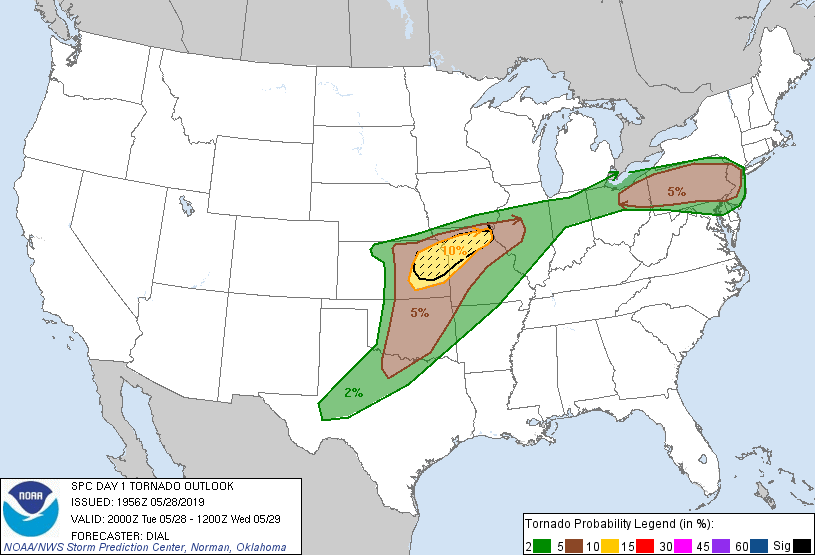
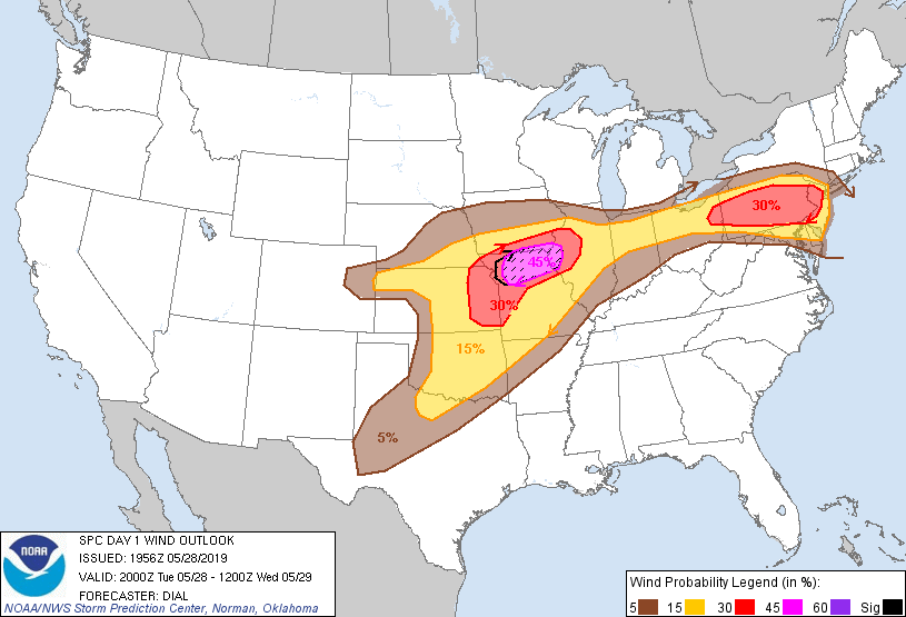
| SPC Day 1 Outlook (2000z) | SPC Day 1 Tornado Outlook (2000z) | SPC Day 1 Wind Outlook (2000z) | SPC Day 1 Hail Outlook (2000z) |
| WPC Rain Outlooks / Discussions | |||
 |
 |
 |
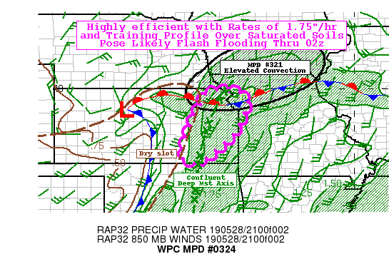 |
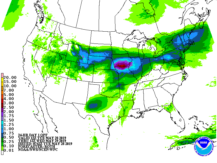
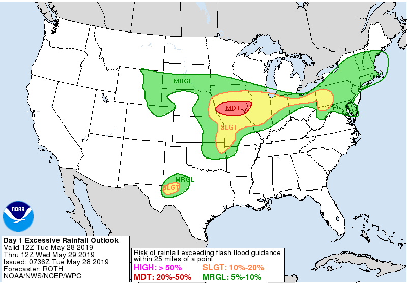
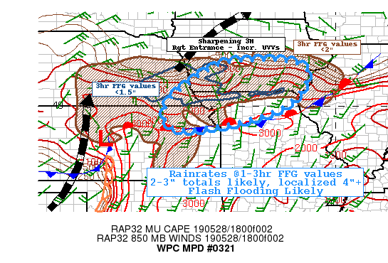
| WPC Day 1 Outlook (0530z) | WPC Day 1 Excessive Rainfall Outlook (0530z) | WPC Mesoscale Discussion #321 (see link for more details) | WPC Mesoscale Discussion #324 (see link for more details) |
 |
 |
||
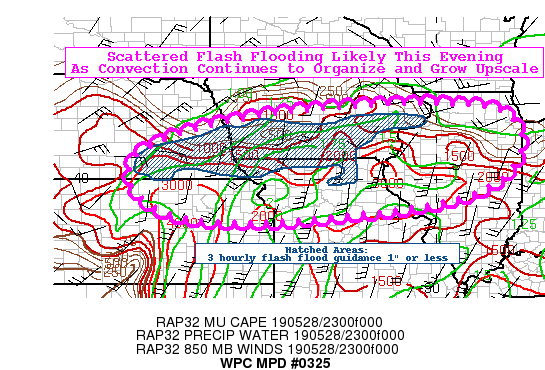
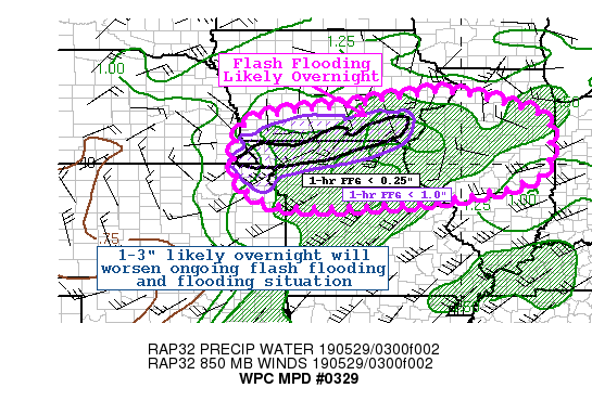
| WPC Mesoscale Discussion #325 (see link for more details) | WPC Mesoscale Discussion #329 (see link for more details) | ||
Local Sounding Analysis
 |
 |
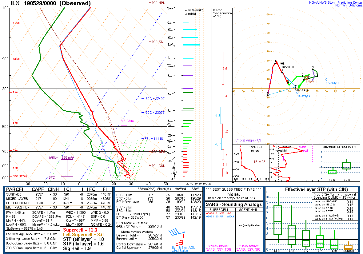 |
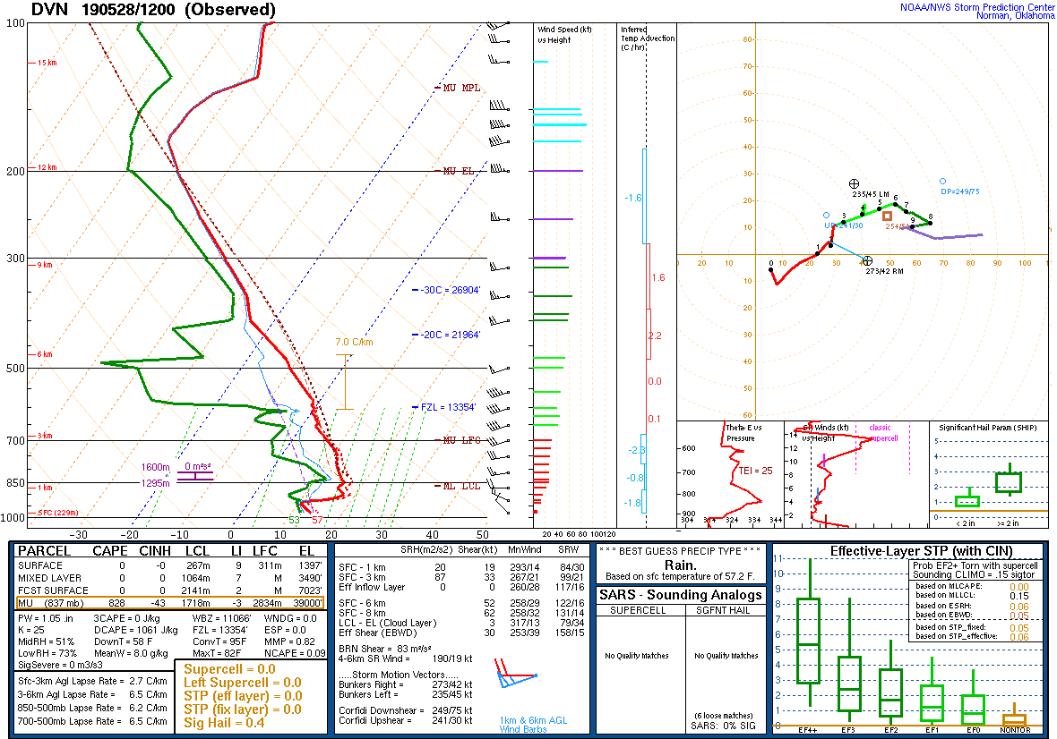
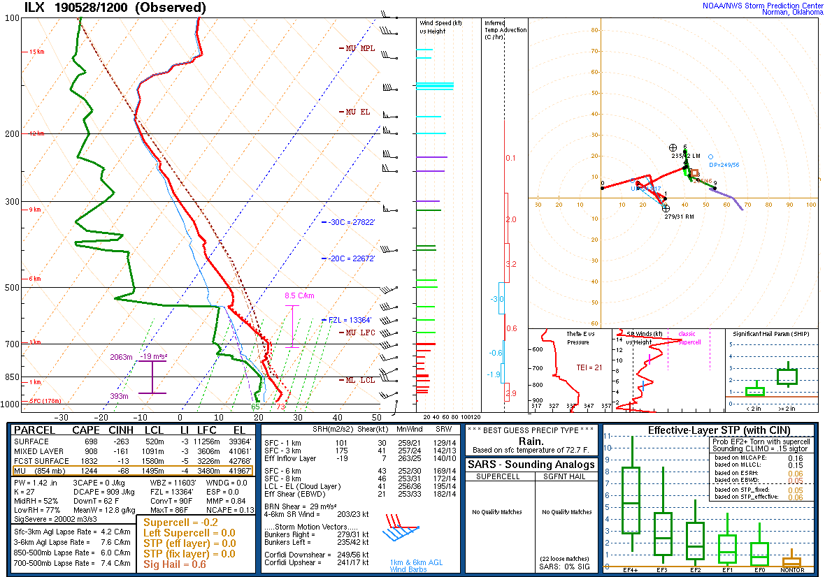
| DVN Sounding 5/28/19 12z | ILX Sounding 5/28/19 12z | ILX Sounding 5/29/19 00z |
SPC Watches Issued For Our Area
 |
 |
|
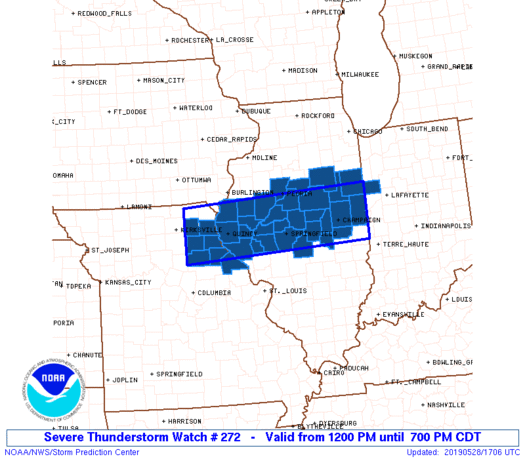
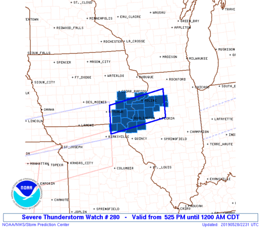
| SPC Severe Thunderstorm Watch #272 (see link for more details) | SPC Severe Thunderstorm Watch #280 (see link for more details) |
SPC Mesoscale Discussions Issued For Our Area
 |
 |
 |
||
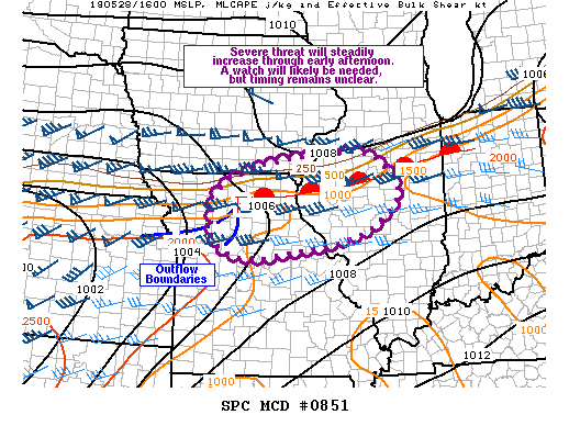
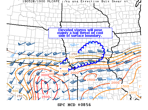
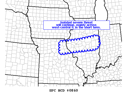
| SPC Mesoscale Discussion #851 (see link for more details) | SPC Mesoscale Discussion #856 (see link for more details) | SPC Mesoscale Discussion #860 (see link for more details) |
SPC - Storm Prediction Center
WPC - Weather Prediction Center
 |
Media use of NWS Web News Stories is encouraged! Please acknowledge the NWS as the source of any news information accessed from this site. |
|