Event Summary: May 16, 2019
|
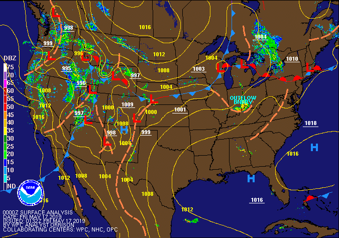
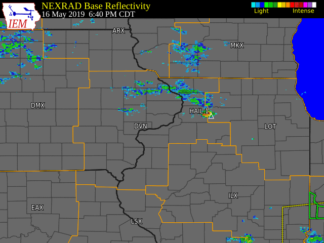
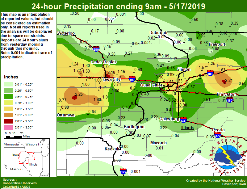
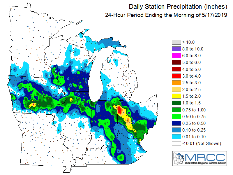
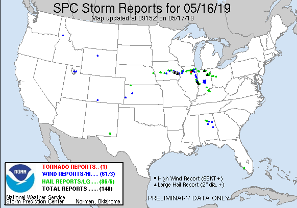
A slow, south moving cold front and an outflow boundary from morning thunderstorms over northern Illinois combined with a hot and humid environment to produce widespread showers and thunderstorms across eastern Iowa and northwest Illinois overnight. Several thunderstorms became severe, and produced large hail and damaging winds. Quarter sized hail was reported across Clinton and Iowa counties, while destructive winds of 70-90 MPH were reported Iowa and Washington Counties. In addition, torrential rainfall amounts of 1-2 inches were reported along the I-80 corridor as storms slowly moved across the area. This lead to flash flooding across many major roadways, including I-80 near Coralville and Highway 965 in Oakdale.
|
|
Storm Reports
| SPC Storm Reports |
 |
000
NWUS53 KDVN 170452
LSRDVN
PRELIMINARY LOCAL STORM REPORT...SUMMARY
NATIONAL WEATHER SERVICE QUAD CITIES IA IL
1152 PM CDT THU MAY 16 2019
..TIME... ...EVENT... ...CITY LOCATION... ...LAT.LON...
..DATE... ....MAG.... ..COUNTY LOCATION..ST.. ...SOURCE....
..REMARKS..
1013 PM HAIL 2 NNW BETTENDORF 41.59N 90.49W
05/16/2019 E0.70 INCH SCOTT IA TRAINED SPOTTER
QUITE A BIT OF HAIL.
1010 PM TSTM WND GST DAVENPORT MUNICIPAL AIR 41.62N 90.58W
05/16/2019 M52 MPH SCOTT IA ASOS
1004 PM TSTM WND DMG 4 NNE MUSCATINE 41.47N 91.04W
05/16/2019 MUSCATINE IA TRAINED SPOTTER
SMALL TREE LIMBS DOWN. ALSO NICKEL SIZE
HAIL.
1004 PM HEAVY RAIN 1 N OAKDALE 41.71N 91.60W
05/16/2019 M1.24 INCH JOHNSON IA PUBLIC
0953 PM TSTM WND DMG LONE TREE 41.49N 91.42W
05/16/2019 JOHNSON IA PUBLIC
SMALL BRANCHES DOWN.
0947 PM FLASH FLOOD 1 NNW OAKDALE 41.72N 91.61W
05/16/2019 JOHNSON IA PUBLIC
HIGHWAY 965 IMPASSABLE BETWEEN OAKDALE AND
FOREVERGREEN ROAD. REPORT VIA SOCIAL MEDIA.
0943 PM FLASH FLOOD 1 W CORALVILLE 41.69N 91.63W
05/16/2019 JOHNSON IA BROADCAST MEDIA
4 TO 6 INCHES OF WATER COVERING I-80
EASTBOUND LANE.
0940 PM TSTM WND GST 2 SE IOWA CITY 41.64N 91.51W
05/16/2019 M64 MPH JOHNSON IA TRAINED SPOTTER
0940 PM TSTM WND GST 2 NW RIVER JCT. 41.50N 91.53W
05/16/2019 M86 MPH WASHINGTON IA BROADCAST MEDIA
0934 PM TSTM WND GST 1 ENE TIFFIN 41.71N 91.66W
05/16/2019 E70 MPH JOHNSON IA TRAINED SPOTTER
WIND AND TORRENTIAL RAIN.
0932 PM TSTM WND GST IOWA CITY MUNICIPAL AIR 41.64N 91.55W
05/16/2019 E62 MPH JOHNSON IA AWOS
0929 PM TSTM WND GST 2 NW RIVER JCT. 41.50N 91.53W
05/16/2019 M77 MPH WASHINGTON IA BROADCAST MEDIA
0927 PM TSTM WND DMG WILLIAMSTOWN 41.57N 91.72W
05/16/2019 JOHNSON IA PUBLIC
SMALL SHEEP SHED BLOWN AWAY.
0926 PM HAIL CAMANCHE 41.79N 90.27W
05/16/2019 M1.00 INCH CLINTON IA PUBLIC
REPORT VIA SOCIAL MEDIA.
0923 PM TSTM WND GST 1 NE NORTH LIBERTY 41.75N 91.60W
05/16/2019 E65 MPH JOHNSON IA TRAINED SPOTTER
ESTIMATED 60 TO 70 MPH WINDS.
0922 PM HAIL 4 SSW DEWITT 41.76N 90.57W
05/16/2019 E0.88 INCH SCOTT IA NWS EMPLOYEE
ALSO 40 MPH WIND.
0922 PM HAIL 1 WNW DEWITT 41.83N 90.57W
05/16/2019 M1.00 INCH CLINTON IA TRAINED SPOTTER
0910 PM HEAVY RAIN WILLIAMSBURG 41.67N 92.00W
05/16/2019 M2.00 INCH IOWA IA TRAINED SPOTTER
RAINFALL IN PAST 30 MINUTES AND STILL
RAINING.
0901 PM HEAVY RAIN VICTOR 41.73N 92.29W
05/16/2019 M1.40 INCH IOWA IA TRAINED SPOTTER
0901 PM TSTM WND DMG WILLIAMSBURG 41.67N 92.01W
05/16/2019 IOWA IA EMERGENCY MNGR
POWER LINES DOWN.
0857 PM TSTM WND GST 1 NNE WILLIAMSBURG 41.68N 92.00W
05/16/2019 M78 MPH IOWA IA TRAINED SPOTTER
MEASURED ON HOME WEATHER STATION.
0851 PM HAIL 2 SSW GENOA BLUFF 41.70N 92.16W
05/16/2019 M1.00 INCH IOWA IA EMERGENCY MNGR
0841 PM HAIL VICTOR 41.73N 92.29W
05/16/2019 E0.88 INCH IOWA IA TRAINED SPOTTER
PEA TO NICKEL SIZE HAIL.
0833 PM TSTM WND GST 2 S KEYSTONE 41.96N 92.20W
05/16/2019 M67 MPH BENTON IA BROADCAST MEDIA
0825 PM HAIL KEYSTONE 42.00N 92.20W
05/16/2019 E0.88 INCH BENTON IA PUBLIC
0820 PM HAIL 1 SSE MORRISON 41.80N 89.96W
05/16/2019 E0.88 INCH WHITESIDE IL TRAINED SPOTTER
HAIL STARTING AGAIN.
0800 PM HAIL 1 SSE MORRISON 41.80N 89.96W
05/16/2019 M0.75 INCH WHITESIDE IL TRAINED SPOTTER
SEVERAL EPISODES OF HAIL FOR PAST 10
MINUTES. NO WIND OR RAIN WITH THE HAIL.
0729 PM TSTM WND GST CLINTON AIRPORT 41.83N 90.33W
05/16/2019 M58 MPH CLINTON IA AWOS
&&
$$
Area Rainfall Amounts
|
24-hr Local Rainfall Map
|
24-hr Regional Rainfall Map
|
24 hour precipitation reports (in Inches),
for eastern Iowa, northwest and west central Illinois,
and northeast Missouri. Reported between Midnight and 9 AM,
Friday May 17, 2019.

....IOWA....
Coralville 1.3 SE                2.50
Sigourney                        2.25
North Liberty 0.7 SSW            2.18
West Branch 2.0 NNW              1.84
Washington 5.8 SW                1.80
Riverdale 0.5 N                  1.72
Marengo 2.6 SSW                  1.72
Brighton                         1.65
Bettendorf 2.2 SE                1.62
Toledo 3 N                       1.59
Bettendorf 1.6 WSW               1.58
Marengo                          1.53
Oskaloosa 1 NNW                  1.35
Le Claire LD14                   1.33
Wellman 4.0 E                    1.31
Marengo 3.6 N                    1.30
Belle Plaine                     1.24
Davenport Arpt 5 N               1.20
Williamsburg                     1.20
Iowa City 8.0 NE                 1.16
Grinnell AWOS 2 SSW              1.15
Pella 4 N                        1.13
Marshalltown 1 NW                1.09
Washington                       1.01
Kalona 7.3 NNW                   1.00
North English                    1.00
Iowa City Arpt                   0.98
Tipton 0.7 N                     0.98
Ottumwa ASOS 6 NNW               0.98
Grinnell 2 SW                    0.91
Eldridge 0.7 SSW                 0.90
Park View 0.2 WSW                0.89
Eldridge 0.6 S                   0.86
Davenport 0.9 WNW                0.83
De Witt                          0.78
Oskaloosa AWOS 9 ESE             0.77
Davenport 0.9 SSW                0.75
Cedar Rapids Arpt 5 SW           0.72
Iowa City                        0.71
Boone 1 SSW                      0.71
NWS Johnston* 5 NNW              0.65
Marshalltown ASOS 4 N            0.64
Fairfield                        0.64
Wapello 0.2 S                    0.63
Fairfax 4.0 NW                   0.61
Muscatine 2.1 N                  0.61
Ainsworth 7.4 N                  0.60
Pella AWOS 2 WSW                 0.58
Muscatine 2N                     0.51
Calamus 2.0 NE                   0.47
Morning Sun 1.7 E                0.43
Cedar Rapids 2.7 NE              0.43
Maquoketa 4 W                    0.36
Hampton 1 N                      0.35
Vinton                           0.29
Perry 0 W                        0.28
New London 1.5 SW                0.28
Marion 1.7 NNW                   0.28
Anamosa 3 SSW                    0.27
Mount Auburn 2.2 NNW             0.22
Tripoli 0 N                      0.20
Waterloo ASOS 5 NW               0.19
Center Point 0.6 NNW             0.18
Independence 0.9 WNW             0.17
Central City 6.7 W               0.15
Charlotte 1.9 WNW                0.13
Cresco 1 NE                      0.12
Burlington Arpt 2 SW             0.09
Delmar 2.3 NW                    0.09
Manchester                       0.08
Salem 3.1 ESE                    0.08
Salem 1S                         0.06
Beaconsfield 1 NNE               0.06
Burlington 6.5 SSW               0.06
Monticello 1 E                   0.05
Coggon                           0.05
Asbury 0.4 SW                    0.04
West Point 7.5 NW                0.04
Peosta 2.9 E                     0.02
Elkader 6SSW                     0.00
Mason City 1 NNE                 0.00
Cascade                          0.00
Strawberry Point                 0.00
Dubuque #3 7 SW                  0.00
Mason City ASOS 6 W              0.00
Rathbun Reservoir 2 N            0.00
Bellevue LD12                    0.00
Guttenberg Dam 10                0.00
Dubuque LD11                     0.00
Centerville 0 NE                 0.00
Keosauqua                        0.00
Dubuque Arpt 7 SW                0.00
Donnellson                       0.00
Keokuk LD19                      0.00
Fayette 1 NW                     0.00
Oelwein AWOS                     0.00
....ILLINOIS....
Walnut 5.3 ENE                   2.21
Rock Falls                       1.63
Morrison 3.2 E                   1.57
Coleta 1.4 SSW                   1.25
Steward                          1.21
Quad City Arpt 3 S               1.08
Coal Valley 2.6 E                1.06
Romeoville                       1.05
Woodhull 0.3 ESE                 0.90
Alpha 2.3 N                      0.76
Coal Valley 1.9 SE               0.71
Moline 1.0 WNW                   0.68
Galesburg                        0.68
Freeport                         0.61
Prophetstown 0.2 SW              0.59
Geneseo 2.0 NW                   0.57
Freeport 1.7 ESE                 0.56
Stockton 3.4 NNE                 0.55
Freeport 1.7 NW                  0.54
Freeport 2.9 WSW                 0.53
Freeport 2.0 NW                  0.53
Rockford ASOS                    0.52
Orangeville 2.8 NW               0.52
New Windsor 2.0 N                0.52
Kewanee 1 E                      0.51
Ill. City LD16 3 WNW             0.51
Mendota 2 SE                     0.50
Illinois City 6.7 SW             0.49
Winslow 4.3 ESE                  0.46
Paw Paw 1 E                      0.44
Galesburg Arpt 3 SW              0.44
Mundelein                        0.42
Ottawa 4 SW                      0.42
Rochelle AWOS                    0.42
Alexis 1 SW                      0.42
Rochelle                         0.41
Roscoe 2SE                       0.41
Dakota 4.8 NW                    0.40
Davis 0.5 N                      0.40
Pearl City 0.4 SW                0.38
Ridott 0.1 NE                    0.37
Princeton 1.1 SE                 0.31
Princeton                        0.31
Tiskilwa 2.1 N                   0.31
Joliet                           0.31
Gladstone LD18                   0.28
Milan 8.8 SSW                    0.24
Minonk                           0.24
Roseville 0.6 WNW                0.23
Monmouth 4NW                     0.22
Shannon 0.2 S                    0.08
La Harpe                         0.07
Savanna 4.6 N                    0.06
Peoria ASOS                      0.05
Prairie City 2S                  0.04
Quincy Dam 21                    0.03
Dallas City 3.0 SSE              0.03
Colchester 3.5 NE                0.01
Tuscola                          0.01
Windsor                          0.00
Quincy ASOS                      0.00
Bloomington Airport              0.00
Lincoln NWS                      0.00
Decatur Airport                  0.00
Galena                           0.00
Augusta                          0.00
Ogden                            0.00
Havana                           0.00
Warsaw 5.8 SE                    0.00
Elizabeth                        0.00
Jacksonville AWOS                0.00
....MISSOURI....
Kirksville ASOS                  0.00
Chillicothe 2 NW                 0.00
Memphis                          0.00
Canton LD20                      0.00
Columbia                         0.00
....WISCONSIN....
La Crosse WFO                    0.77
Whitewater                       0.73
Steuben 4SE 3 NE                 0.68
Allenton-WWTP .6 NW              0.63
Viroqua                          0.63
Darlington                       0.50
Madison-ASOS                     0.49
Delavan-1 W-WWTP 1 W             0.44
Prairie du Chien AWOS            0.42
Brodhead 1 SW                    0.39
Monroe 1 W                       0.38
Beloit-College                   0.04
Watertown-AWOS                   0.00
....MINNESOTA....
Preston                          0.00
Theilman 1SSW                    0.00
Environmental Analysis / Other Information
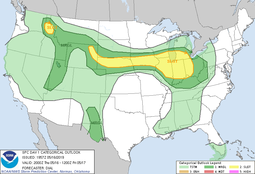
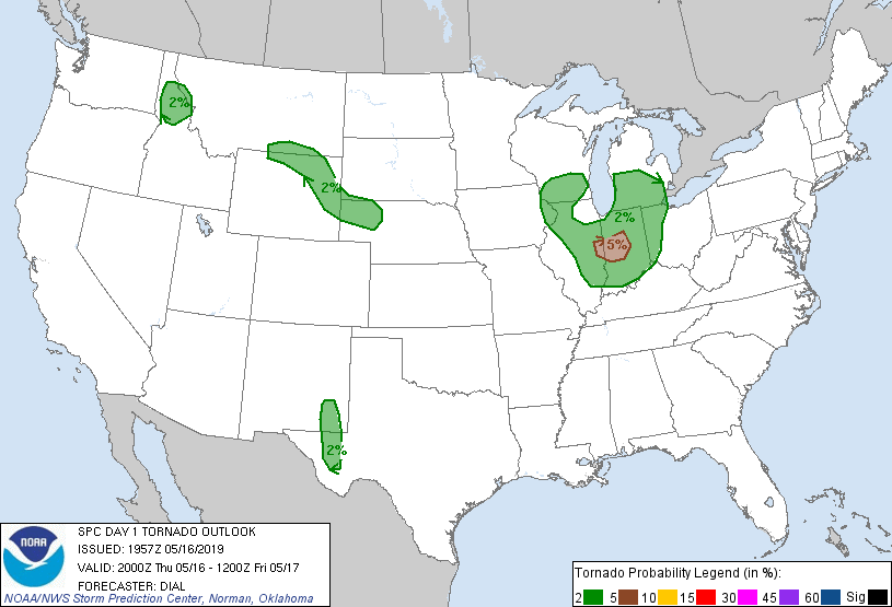
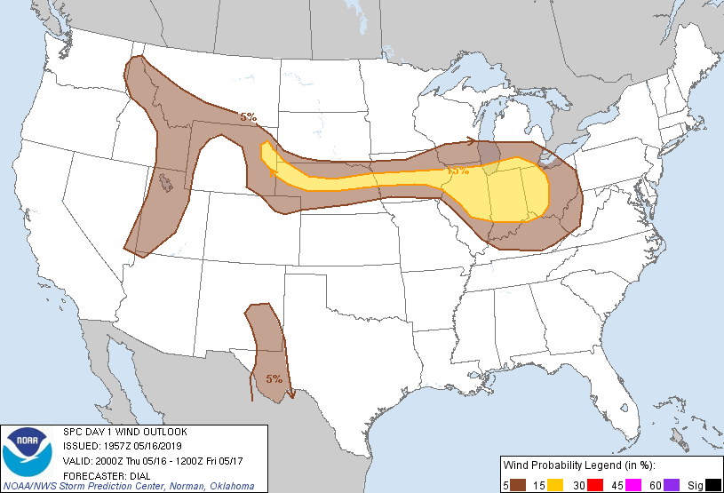
SPC Convective Outlooks
 |
 |
 |
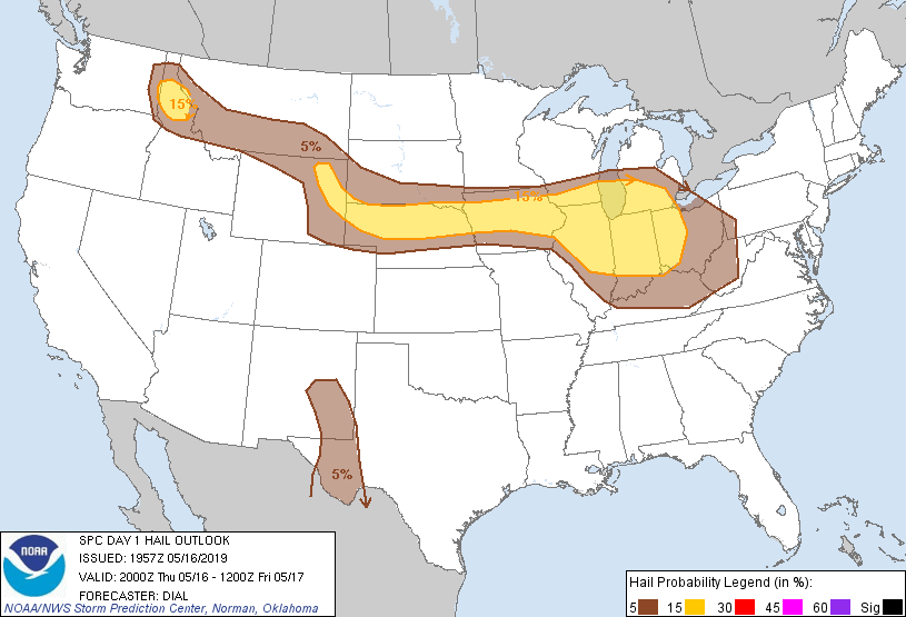 |
| SPC Day 1 Outlook (2000z) | SPC Day 1 Tornado Outlook (2000z) | SPC Day 1 Wind Outlook (2000z) | SPC Day 1 Hail Outlook (2000z) |
Local Sounding Analysis
 |
 |
|
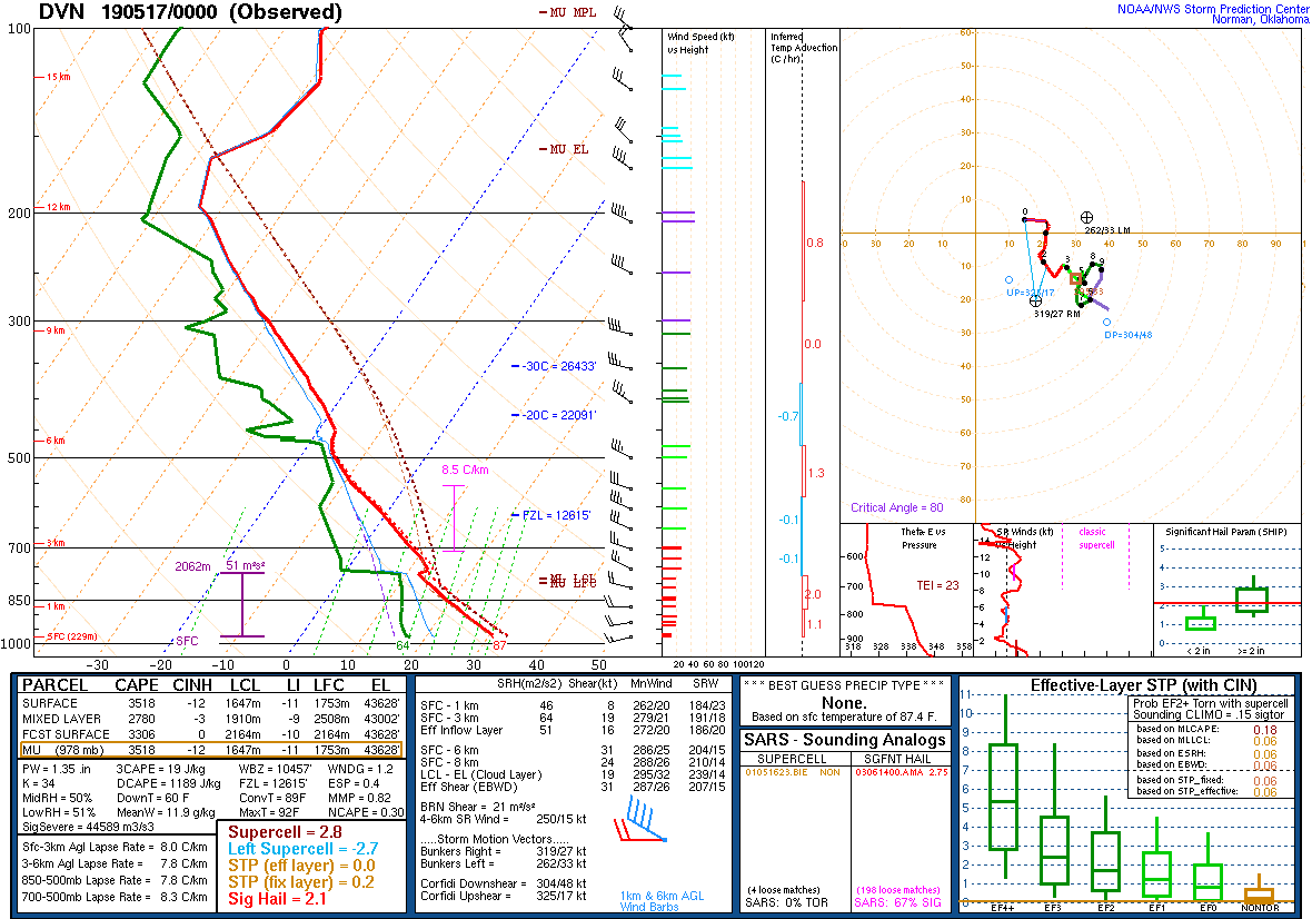
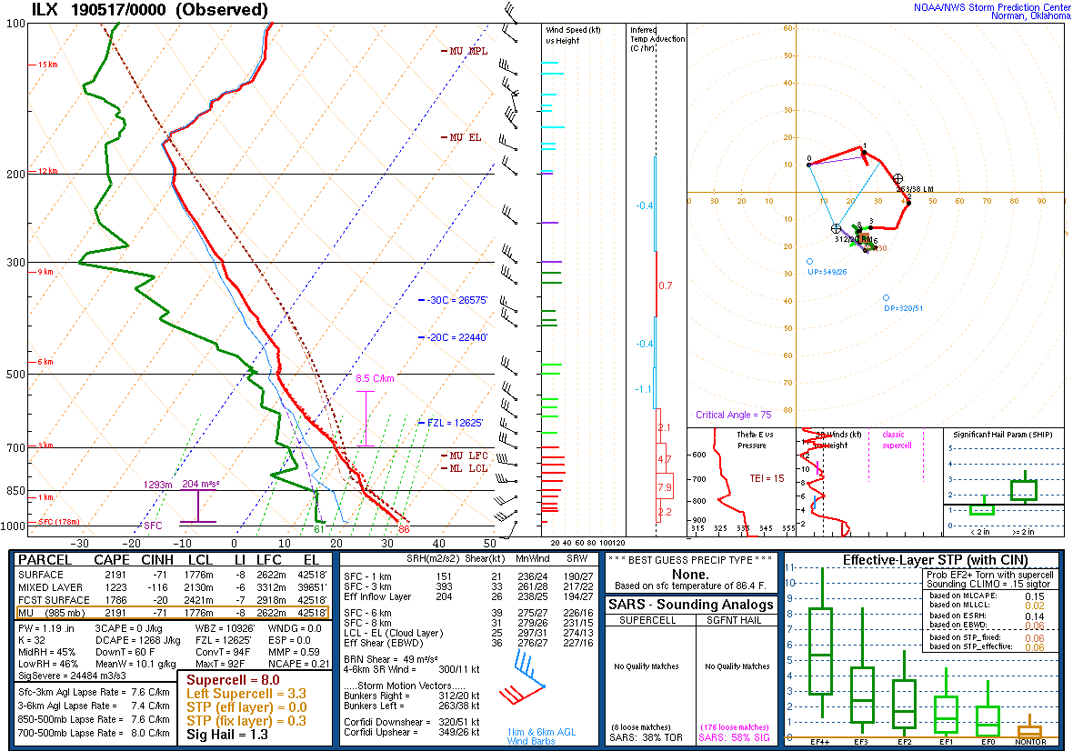
| DVN Sounding 5/17/19 00z | ILX Sounding 5/17/19 00z |
SPC Watches Issued For Our Area
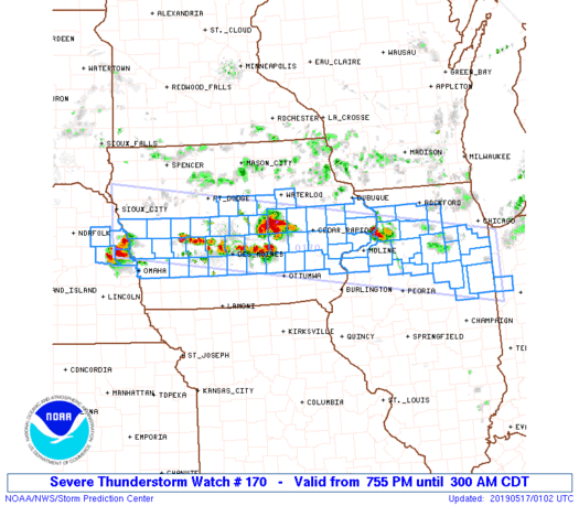 |
| SPC Severe Thunderstorm Watch #170 (see link for more details) |
SPC Mesoscale Discussions Issued For Our Area
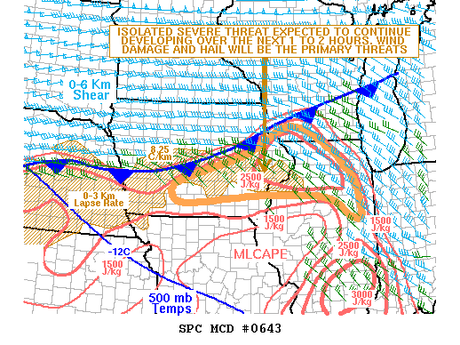 |
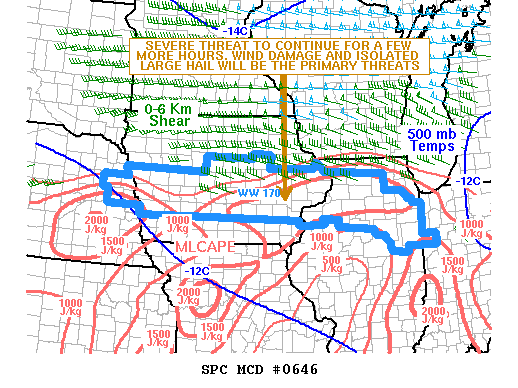 |
|
| SPC Mesoscale Discussion #643 (see link for more details) | SPC Mesoscale Discussion #646 (see link for more details) |
SPC - Storm Prediction Center
 |
Media use of NWS Web News Stories is encouraged! Please acknowledge the NWS as the source of any news information accessed from this site. |
|