|
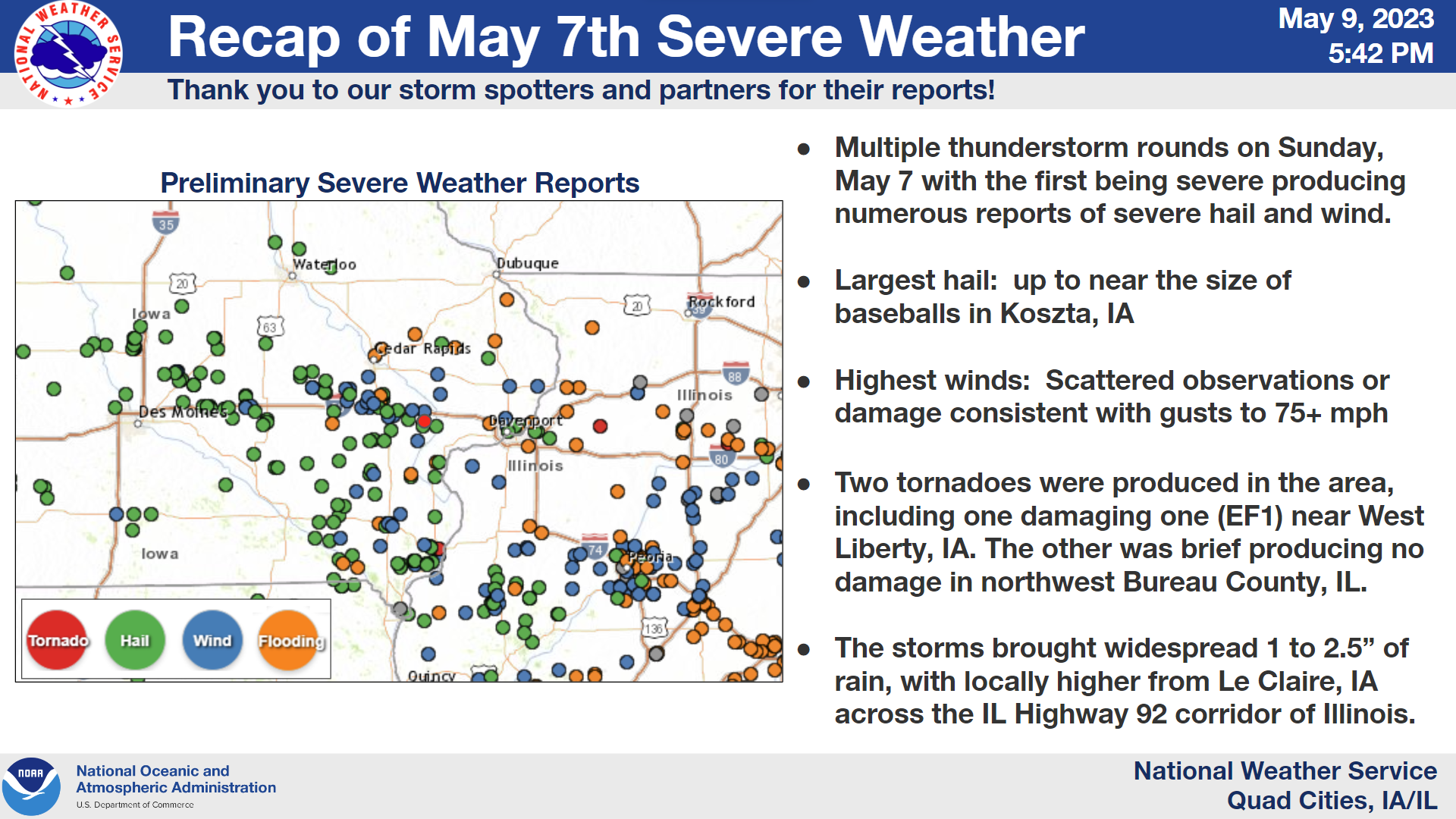
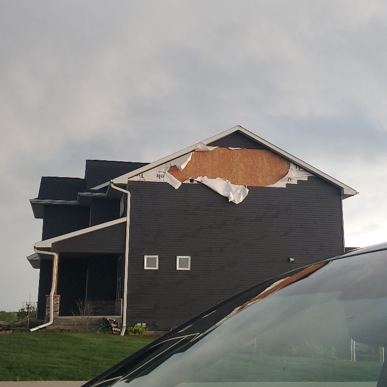
Overview ​Several rounds of severe thunderstorms impacted the area on Sunday May 7, 2023, adding to an already busy weekend from storms the previous day. The first round of storms evolved from a complex Sunday morning in Nebraska into northwest Iowa, which strengthened considerably as they encountered near- to record warm air across the area for early May. Plentiful instability and vertical shear were in place, allowing storms to grow and intensify quickly as they traversed the area. Two areas of storms were present during the mid-late afternoon, one entering the Cedar Rapids/Iowa City metros and another around the Burlington/Fort Madison metros. The first was the most severe, producing hail up to baseball size in Koszta, IA and widespread wind damage, especially around West Liberty, IA. This storm, and storms to the west, eventually merged into a cluster of severe thunderstorms producing large hail and destructive winds around 70-75 MPH all the way to Mount Pleasant IA and Macomb IL. The later, produced sporadic reports of quarter to half dollar size hail, along with a brief landspout tornado east of Yorktown, IL. Additional storms developed to the northeast of this complex, stretching along and just north of Interstate 80 through north central Illinois. This mainly produced heavy rainfall and brief wind gusts, with some roads in northern Bureau County IL seeing water issues. There was also severe blowing dust which was especially bad near I-55 in north central Illinois. Even more thunderstorms developed overnight across the area, and mainly produced torrential rain and isolated large hail reports. Most notably, this complex of storms combined with the previous round produced a whopping 4.15" of rain in Le Claire, IA. Elsewhere, rainfall reports were mainly between 1” and 3”. |
|
Tornadoes
|
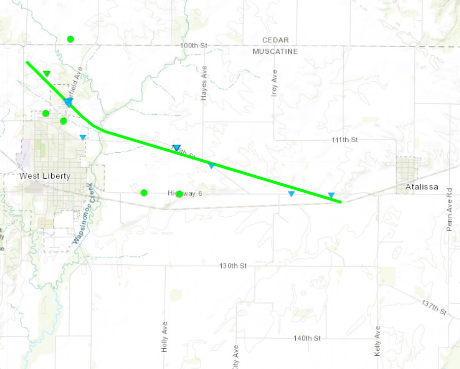
Tornado #1 - 1 NNW West Liberty, IA
|
||||||||||||||||
|
Tornado #2 - 3 E Yorktown, IL
Track Map 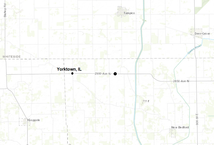  |
||||||||||||||||
The Enhanced Fujita (EF) Scale classifies tornadoes into the following categories:
| EF0 Weak 65-85 mph |
EF1 Moderate 86-110 mph |
EF2 Significant 111-135 mph |
EF3 Severe 136-165 mph |
EF4 Extreme 166-200 mph |
EF5 Catastrophic 200+ mph |
 |
|||||
Wind & Hail
 |
 |
 |
 |
| West Liberty - Atalissa, IA Muscatine Co. EMA |
Tiffin, IA Johnson Co. EMA |
Tiffin, IA Johnson Co. EMA |
Tiffin, IA Johnson Co. EMA |
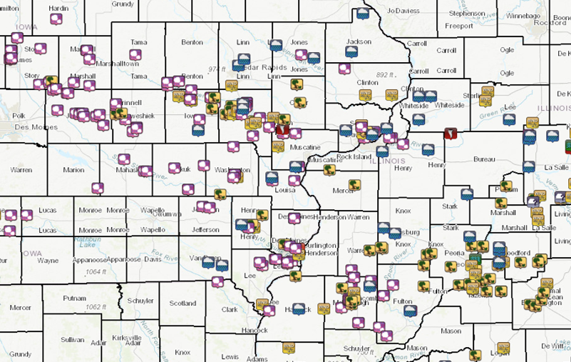
Storm Reports
| Storm Reports 5/7 12pm - 5/8 12pm | SPC Severe Weather Event: May 07, 2023 |
 |
 |
PRELIMINARY LOCAL STORM REPORT...SUMMARY
NATIONAL WEATHER SERVICE QUAD CITIES IA IL
438 PM CDT TUE MAY 9 2023
..TIME... ...EVENT... ...CITY LOCATION... ...LAT.LON...
..DATE... ....MAG.... ..COUNTY LOCATION..ST.. ...SOURCE....
..REMARKS..
0432 PM HAIL 4 N MARENGO 41.85N 92.07W
05/07/2023 M1.50 INCH IOWA IA TRAINED SPOTTER
0432 PM TSTM WND GST 2 SSE KOSZTA 41.81N 92.18W
05/07/2023 E70 MPH IOWA IA PUBLIC
ESTIMATED 70 MPH WINDS NEAR G AVENUE AND
212.
0433 PM TSTM WND GST 1 WSW MARENGO 41.79N 92.08W
05/07/2023 E65 MPH IOWA IA TRAINED SPOTTER
0435 PM HAIL 1 WSW MARENGO 41.79N 92.08W
05/07/2023 M1.00 INCH IOWA IA TRAINED SPOTTER
MOSTLY DIMES.
0435 PM HAIL 1 S MARENGO 41.78N 92.07W
05/07/2023 M1.00 INCH IOWA IA PUBLIC
QUARTER SIZED HAIL.
0435 PM TSTM WND GST 1 S MARENGO 41.78N 92.07W
05/07/2023 E60 MPH IOWA IA PUBLIC
ESTIMATED HIGHER THAN 60 MPH WIND GUSTS.
0444 PM HAIL 1 SSE DENMARK 40.74N 91.33W
05/07/2023 M1.00 INCH LEE IA EMERGENCY MNGR
0445 PM TSTM WND DMG HOMESTEAD 41.77N 91.87W
05/07/2023 IOWA IA TRAINED SPOTTER
10X10 SHED WAS BLOWN INTO A FENCE AND
SEVERAL HOUSES NEARBY ON HWY 6 HAD LARGE
TREES DOWN.
0447 PM HAIL 1 W WEST POINT 40.72N 91.47W
05/07/2023 E1.75 INCH LEE IA EMERGENCY MNGR
0447 PM HAIL 1 S DENMARK 40.74N 91.34W
05/07/2023 E1.00 INCH LEE IA EMERGENCY MNGR
0455 PM HAIL HOMESTEAD 41.77N 91.87W
05/07/2023 E0.88 INCH IOWA IA TRAINED SPOTTER
0456 PM TSTM WND GST AMANA 41.80N 91.90W
05/07/2023 E65 MPH IOWA IA PUBLIC
TIME ESTIMATED FROM RADAR.
0456 PM HAIL AMANA 41.80N 91.90W
05/07/2023 E1.50 INCH IOWA IA TRAINED SPOTTER
TIME ESTIMATED FROM RADAR.
0457 PM TSTM WND DMG AMANA 41.80N 91.87W
05/07/2023 IOWA IA TRAINED SPOTTER
GUTTERS BLOWN OFF. 10 INCH DIAMETER BRANCH
DOWN. DUMPSTER BLEW DOWN ALLEY.
0458 PM TSTM WND DMG 3 SSE OXFORD 41.69N 91.77W
05/07/2023 JOHNSON IA EMERGENCY MNGR
SEMI BLOWN OVER CARRYING US MAIL ON
INTERSTATE 80 NEAR MILE MARKER 232. TIME
ESTIMATED FROM RADAR.
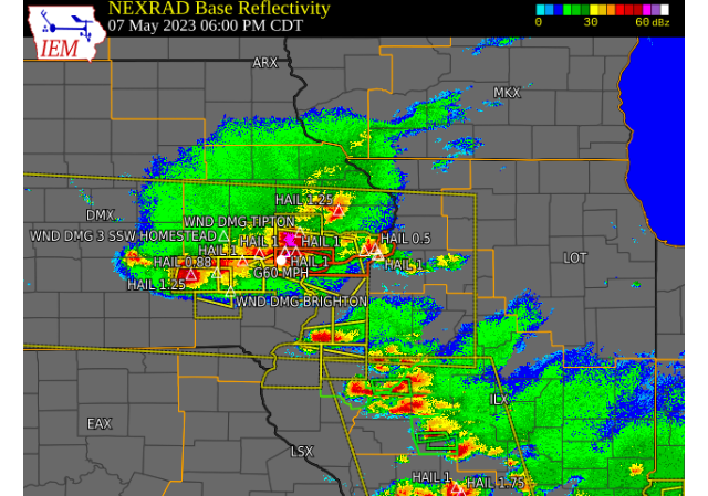
0500 PM TSTM WND GST CEDAR RAPIDS MUNICIPALI 41.88N 91.72W
05/07/2023 M66 MPH LINN IA ASOS
ASOS STATION KCID CEDAR RAPIDS ARPT.
0500 PM TSTM WND DMG 1 ESE IOWA CITY 41.65N 91.52W
05/07/2023 JOHNSON IA TRAINED SPOTTER
SEVERAL MEDIUM SIZED TREE LIMBS DOWN.
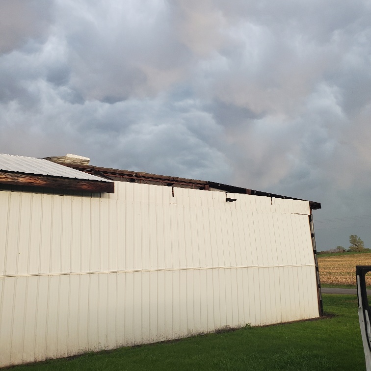
0500 PM TSTM WND DMG 4 NW TIFFIN 41.75N 91.72W
05/07/2023 JOHNSON IA EMERGENCY MNGR
DAMAGE TO HANGAR AT GREENCASTLE AIRPORT,
TIME ESTIMATED FROM RADAR.
0503 PM HAIL WEVER 40.72N 91.23W
05/07/2023 E1.00 INCH LEE IA TRAINED SPOTTER
0504 PM HAIL 1 SE DENMARK 40.74N 91.33W
05/07/2023 E1.25 INCH LEE IA EMERGENCY MNGR
0505 PM TSTM WND DMG 3 WNW TIFFIN 41.72N 91.73W
05/07/2023 JOHNSON IA TRAINED SPOTTER
SEVERAL TREES DOWN AND TOPPED IN FW KENT
PARK. TIME ESTIMATED.
0508 PM TSTM WND GST 2 SW TIFFIN 41.69N 91.70W
05/07/2023 M74 MPH JOHNSON IA TRAINED SPOTTER
TIME ESTIMATED. ALSO DIME TO NICKEL HAIL.
0509 PM HAIL WEVER 40.71N 91.23W
05/07/2023 M1.75 INCH LEE IA PUBLIC
TIME ESTIMATED FROM RADAR.
0509 PM HAIL 1 ENE TIFFIN 41.71N 91.66W
05/07/2023 E0.88 INCH JOHNSON IA TRAINED SPOTTER
0509 PM TSTM WND DMG 1 ENE TIFFIN 41.71N 91.66W
05/07/2023 JOHNSON IA TRAINED SPOTTER
SEVERAL SIGNIFICANT TREES DOWN OVER 1 FOOT
AND A HALF IN DIAMETER.
0510 PM TSTM WND GST TIFFIN 41.71N 91.67W
05/07/2023 E75 MPH JOHNSON IA TRAINED SPOTTER
70 TO 80 MPH WIND GUSTS. DUST WITH REDUCED
VISIBILITY. ALSO DIME TO NICKEL HAIL.
0510 PM HAIL 1 ESE WILLIAMSBURG 41.66N 92.00W
05/07/2023 M1.00 INCH IOWA IA CO-OP OBSERVER
DELAYED REPORT. TIME ESTIMATED FROM RADAR.
0511 PM TSTM WND DMG 1 NNE NORTH LIBERTY 41.76N 91.60W
05/07/2023 JOHNSON IA TRAINED SPOTTER
SEVERAL LARGE TREE BRANCHES DOWN IN TOWN,
WITH MULTIPLE SMALLER LIMBS. TIME ESTIMATED
FROM RADAR.
0513 PM HAIL 2 W CORALVILLE 41.69N 91.63W
05/07/2023 E1.00 INCH JOHNSON IA TRAINED SPOTTER
0513 PM TSTM WND DMG MIDDLETOWN 40.84N 91.26W
05/07/2023 DES MOINES IA TRAINED SPOTTER
TREE DOWN.
0519 PM TSTM WND GST IOWA CITY MUNICIPALITY 41.63N 91.55W
05/07/2023 M73 MPH JOHNSON IA ASOS
ASOS STATION KIOW IOWA CITY ARPT.
0519 PM TSTM WND GST 2 NNW NORTH LIBERTY 41.76N 91.62W
05/07/2023 E60 MPH JOHNSON IA TRAINED SPOTTER
0520 PM HAIL 2 NNE NORTH LIBERTY 41.77N 91.59W
05/07/2023 E1.00 INCH JOHNSON IA PUBLIC
CORRECTS PREVIOUS HAIL REPORT FROM 2 NNE
NORTH LIBERTY. REPORT FROM MPING: QUARTER
(1.00 IN.).
0523 PM HAIL 4 ENE IOWA CITY 41.67N 91.47W
05/07/2023 E1.00 INCH JOHNSON IA TRAINED SPOTTER
0524 PM HAIL 1 ENE NORTH LIBERTY 41.75N 91.59W
05/07/2023 E1.00 INCH JOHNSON IA TRAINED SPOTTER
0529 PM TSTM WND GST 2 SE IOWA CITY 41.64N 91.51W
05/07/2023 M63 MPH JOHNSON IA TRAINED SPOTTER
55 KNOT WIND GUST.
0535 PM TSTM WND GST WEST BRANCH 41.67N 91.35W
05/07/2023 M70 MPH CEDAR IA EMERGENCY MNGR
0536 PM HAIL 2 WSW DOWNEY 41.61N 91.39W
05/07/2023 E1.50 INCH JOHNSON IA TRAINED SPOTTER
TIME ESTIMATED FROM RADAR.
0545 PM HAIL WEST LIBERTY 41.57N 91.27W
05/07/2023 U1.00 INCH MUSCATINE IA PUBLIC
REPORT FROM MPING: QUARTER (1.00 IN.).
0548 PM TORNADO 1 NNW WEST LIBERTY 41.59N 91.27W
05/07/2023 MUSCATINE IA NWS STORM SURVEY
EF-1 TORNADO CONFIRMED BY NWS STORM SURVEY
IN TANDEM WITH MUSCATINE COUNTY EMERGENCY
MANAGEMENT. THIS TORNADO DEVELOPED JUST
NORTH-NORTHWEST OF WEST LIBERTY AND TRACKED
ACROSS THE FAR NORTHEAST PART OF TOWN BEFORE
EVENTUALLY CROSSING OVER U.S. HIGHWAY 6
BETWEEN WEST LIBERTY AND ATALISSA AND
DIMINISHING SHORTLY AFTER. THE EXTENT OF THE
DAMAGE WAS MAINLY TO OUTBUILDINGS, WITH
SEVERAL WALLS AND ROOFS OF THESE COLLAPSED
AND IN SOME CASES BLOWN ACROSS A DOWNSTREAM
FIELD. A FEW LARGE TREES WERE ALSO SNAPPED
IN ADDITION TO TWO UTILITY POLES. A LARGE
METAL BATTING CAGE ANCHORED INTO CONCRETE
WAS TWISTED AND BENT SHARPLY AT ITS BASE.
TORNADO LASTED 6 MINUTES ON THE GROUND
BEFORE LIFTING.
0550 PM HAIL KALONA 41.48N 91.70W
05/07/2023 E1.00 INCH WASHINGTON IA TRAINED SPOTTER
0551 PM TSTM WND DMG SPRINGDALE 41.66N 91.26W
05/07/2023 CEDAR IA EMERGENCY MNGR
SEMI TRAILER BLOWN DOWN ALONG I-80.
0552 PM HAIL 1 S ELWOOD 41.99N 90.73W
05/07/2023 M1.25 INCH CLINTON IA PUBLIC
0555 PM HAIL WEST LIBERTY 41.57N 91.27W
05/07/2023 E1.75 INCH MUSCATINE IA PUBLIC
REPORT FROM MPING: GOLF BALL (1.75 IN.).
0555 PM HAIL KEOTA 41.36N 91.96W
05/07/2023 M0.88 INCH KEOKUK IA TRAINED SPOTTER
0558 PM HAIL 1 W SIGOURNEY 41.34N 92.22W
05/07/2023 M1.25 INCH KEOKUK IA TRAINED SPOTTER
TIME ESTIMATED FROM RADAR.
0559 PM TSTM WND DMG TIPTON 41.77N 91.12W
05/07/2023 CEDAR IA EMERGENCY MNGR
LARGE TREE FELL ON A SHED. TIME ESTIMATED
FROM RADAR.
0600 PM HAIL ATALISSA 41.57N 91.16W
05/07/2023 M1.00 INCH MUSCATINE IA PUBLIC
0602 PM HAIL 2 SSE HILLS 41.55N 91.53W
05/07/2023 E1.00 INCH JOHNSON IA TRAINED SPOTTER
0603 PM TSTM WND GST NICHOLS 41.48N 91.31W
05/07/2023 E60 MPH MUSCATINE IA TRAINED SPOTTER
WIND GUST ESTIMATED 50-60 MPH.
0610 PM TSTM WND GST WASHINGTON AIRPORT 41.28N 91.67W
05/07/2023 M59 MPH WASHINGTON IA AWOS
AWOS.
0611 PM HAIL 2 NE BARSTOW 41.54N 90.32W
05/07/2023 E1.00 INCH ROCK ISLAND IL TRAINED SPOTTER
0611 PM TSTM WND DMG BRIGHTON 41.17N 91.82W
05/07/2023 WASHINGTON IA TRAINED SPOTTER
12 INCH DIAMETER TREE BLOWN DOWN. TIME
ESTIMATED.
0612 PM HAIL 1 NNE BETTENDORF 41.58N 90.47W
05/07/2023 M0.88 INCH SCOTT IA TRAINED SPOTTER
DIME TO NICKEL HAIL.
0617 PM HAIL OLLIE 41.20N 92.10W
05/07/2023 M1.25 INCH KEOKUK IA PUBLIC
CORRECTS PREVIOUS HAIL REPORT FROM OLLIE.
0621 PM HAIL FRUITLAND 41.35N 91.13W
05/07/2023 E1.75 INCH MUSCATINE IA TRAINED SPOTTER
0623 PM HAIL WASHINGTON 41.30N 91.69W
05/07/2023 U1.00 INCH WASHINGTON IA PUBLIC
REPORT FROM MPING: QUARTER (1.00 IN.).
0625 PM HAIL WASHINGTON 41.30N 91.69W
05/07/2023 E1.00 INCH WASHINGTON IA TRAINED SPOTTER
0626 PM HAIL 1 SSW WASHINGTON 41.28N 91.70W
05/07/2023 E1.00 INCH WASHINGTON IA TRAINED SPOTTER
0628 PM TSTM WND GST DAVENPORT MUNICIPALITY 41.62N 90.58W
05/07/2023 M64 MPH SCOTT IA ASOS
ASOS STATION KDVN DAVENPORT ARPT.
0628 PM NON-TSTM WND DMG STANWOOD 41.89N 91.15W
05/07/2023 CEDAR IA EMERGENCY MNGR
CORRECTS PREVIOUS TSTM WND DMG REPORT FROM
STANWOOD. TREE LIMBS DOWN ACROSS TOWN AND
POWERLINES DOWN.
0630 PM HAIL GOOD HOPE 40.56N 90.67W
05/07/2023 E2.00 INCH MCDONOUGH IL PUBLIC
0631 PM HAIL 1 SE GRANDVIEW 41.26N 91.17W
05/07/2023 M0.88 INCH LOUISA IA TRAINED SPOTTER
0631 PM TSTM WND GST 1 SE CLINTON MUNICIPALI 41.82N 90.32W
05/07/2023 M66 MPH CLINTON IA AWOS
AWOS STATION KCWI CLINTON ARPT.
0632 PM TSTM WND GST DAVENPORT MUNICIPALITY 41.62N 90.58W
05/07/2023 M67 MPH SCOTT IA ASOS
ASOS STATION KDVN DAVENPORT ARPT.
0632 PM TSTM WND GST 2 NE DAVENPORT 41.57N 90.57W
05/07/2023 E70 MPH SCOTT IA NWS EMPLOYEE
OFF DUTY NWS EMPLOYEE ESTIMATED WINDS OF 70
MPH. HE ALSO REPORTED NICKEL SIZE HAIL AND
LARGE TREE BRANCHES DOWN NEAR 53RD STREET
AND US 61 IN DAVENPORT.
0634 PM HAIL 3 S SWAN CREEK 40.62N 90.65W
05/07/2023 U2.50 INCH MCDONOUGH IL PUBLIC
REPORT FROM MPING: TENNIS BALL (2.50 IN.).
0635 PM TSTM WND DMG 2 S MOUNT JOY 41.58N 90.54W
05/07/2023 SCOTT IA TRAINED SPOTTER
3 INCH TREE SNAPPED AT BASE.
0635 PM HAIL 3 NNE FAIRFIELD MUNICIP 41.09N 91.97W
05/07/2023 E1.75 INCH JEFFERSON IA PUBLIC
TIME ESTIMATED.
0635 PM TSTM WND DMG 4 WSW MOUNT UNION 41.03N 91.45W
05/07/2023 HENRY IA TRAINED SPOTTER
WIND FROM THE NORTH ESTIMATED TO BE 80 MPH.
DESCRIBED AS LIKE A HURRICANE. THE STRONG
WINDS LASTED FOR ABOUT 20 MINUTES. POWER OUT
ABOUT 630 PM BEFORE WIND. A 6 INCH DIAMETER
TREE LIMB BLOWN DOWN AND SMALLER BRANCHES.
ALSO SOME SCAFFOLDING WAS BLOWN INTO AT
TREE. TIME ESTIMATED.
0638 PM TSTM WND DMG 2 SW MOUNT PLEASANT 40.95N 91.57W
05/07/2023 HENRY IA PUBLIC
ROOF TORN OFF A MANUFACTURED HOME DUE TO THE
STRAIGHT LINE WINDS.
0640 PM TSTM WND DMG 1 SW BUFFALO PRAIRIE 41.33N 90.86W
05/07/2023 MERCER IL 911 CALL CENTER
POWERLINES DOWNED BY THUNDERSTORM WINDS.
TIME BASED ON RADAR AND POWER OUTAGE MAPS.
0640 PM HAIL 2 E COLCHESTER 40.42N 90.76W
05/07/2023 E0.88 INCH MCDONOUGH IL TRAINED SPOTTER
PEA TO NICKEL HAIL COVERED GROUND.
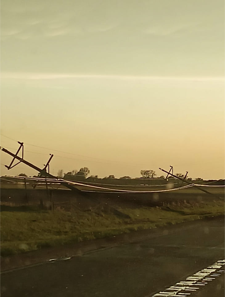
0640 PM TORNADO 3 E YORKTOWN 41.57N 89.80W
05/07/2023 BUREAU IL BROADCAST MEDIA
EFU LANDSPOUT TORNADO REPORTED BY MEDIA.
0643 PM HAIL 1 NE COLUMBUS CITY 41.26N 91.36W
05/07/2023 E0.88 INCH LOUISA IA TRAINED SPOTTER
0645 PM HAIL 3 ESE OSBORN 41.50N 90.22W
05/07/2023 E0.70 INCH HENRY IL TRAINED SPOTTER
0645 PM HAIL 1 SW PERLEE 41.08N 91.91W
05/07/2023 E0.88 INCH JEFFERSON IA TRAINED SPOTTER
0648 PM HAIL 2 N BUSHNELL 40.58N 90.50W
05/07/2023 M1.50 INCH MCDONOUGH IL TRAINED SPOTTER
DELAYED REPORT. TIME ESTIMATED FROM RADAR.
0648 PM TSTM WND DMG MOUNT PLEASANT 40.97N 91.55W
05/07/2023 HENRY IA PUBLIC
LARGE BRANCHES DOWN. RELAYED BY KTVO.
0649 PM HAIL 3 SW PRAIRIE CITY 40.60N 90.50W
05/07/2023 E1.75 INCH MCDONOUGH IL TRAINED SPOTTER
0650 PM TSTM WND GST MOUNT PLEASANT MUNICIPA 40.95N 91.52W
05/07/2023 M77 MPH HENRY IA AWOS
AWOS.
0655 PM HAIL 1 W MACOMB 40.47N 90.70W
05/07/2023 E1.00 INCH MCDONOUGH IL TRAINED SPOTTER
0658 PM HAIL 1 SSE MACOMB 40.46N 90.67W
05/07/2023 E1.00 INCH MCDONOUGH IL PUBLIC
REPORT FROM MPING: QUARTER (1.00 IN.).
0658 PM HEAVY RAIN PARNELL 41.59N 92.01W
05/07/2023 M1.30 INCH IOWA IA PUBLIC
0700 PM HAIL 3 NNE ATKINSON 41.46N 90.00W
05/07/2023 M1.00 INCH HENRY IL TRAINED SPOTTER
DELAYED REPORT. TIME ESTIMATED FROM RADAR.
0704 PM HAIL 1 NW MACOMB 40.48N 90.69W
05/07/2023 E1.00 INCH MCDONOUGH IL TRAINED SPOTTER
0705 PM HAIL MACOMB 40.47N 90.68W
05/07/2023 M1.00 INCH MCDONOUGH IL BROADCAST MEDIA
ALSO SOME MPING REPORTS OF QUARTER SIZED
HAIL IN MACOMB.
0714 PM HEAVY RAIN MEDIAPOLIS 41.01N 91.17W
05/07/2023 U1.00 INCH DES MOINES IA TRAINED SPOTTER
HIGH WIND GUSTS AND HEAVY RAIN.
0719 PM FUNNEL CLOUD 1 W BURLINGTON 40.81N 91.13W
05/07/2023 DES MOINES IA PUBLIC
FUNNEL CLOUDS DIPPING UP AND DOWN NOT
TOUCHING THE GROUND.
0720 PM TSTM WND DMG 1 N SHALE CITY 41.23N 90.64W
05/07/2023 MERCER IL 911 CALL CENTER
REPORTS OF TREES AND POWERLINES DOWN ALL
ACROSS THE COUNTY.
0721 PM HAIL MEDIAPOLIS 41.01N 91.17W
05/07/2023 E1.00 INCH DES MOINES IA TRAINED SPOTTER
NICKLE TO QUARTER WITH HEAVY RAIN.
0730 PM TSTM WND DMG 1 NNE MOUNT PLEASANT 40.97N 91.54W
05/07/2023 HENRY IA TRAINED SPOTTER
PARKING SIGNS BENT OVER. TIME ESTIMATED.
0730 PM HAIL 1 SSE BEAVERDALE 40.83N 91.21W
05/07/2023 E1.00 INCH DES MOINES IA PUBLIC
60-65 MPH GUST AND SHEET RAIN.
0731 PM TSTM WND GST 1 S BURLINGTON REGIONAL 40.77N 91.13W
05/07/2023 M60 MPH DES MOINES IA ASOS
ASOS STATION KBRL BURLINGTON ARPT.
0734 PM HAIL 1 SE WEST BURLINGTON 40.81N 91.16W
05/07/2023 E1.00 INCH DES MOINES IA TRAINED SPOTTER
0742 PM HAIL 2 SW MOUNT PLEASANT 40.95N 91.57W
05/07/2023 E2.00 INCH HENRY IA PUBLIC
0748 PM HIGH SUST WINDS 1 SSW MOOAR 40.44N 91.45W
05/07/2023 E60 MPH LEE IA TRAINED SPOTTER
0754 PM TSTM WND DMG 1 E BERWICK 40.80N 90.51W
05/07/2023 WARREN IL FIRE DEPT/RESCUE
DELAYED REPORT. ONE OUTBUILDING DETROYED AND
ANOTHER HEAVILY DAMAGED WITH A COUPLE LARGE
TREES UPROOTED. MAXIMUM WIND SPEEDS
ESTIMATED 80-90 MPH.
0756 PM TSTM WND DMG DALLAS CITY 40.63N 91.16W
05/07/2023 HANCOCK IL AMATEUR RADIO
REPORT OF TREE DOWN IN DALLAS CITY. TIME
ESTIMATED BY RADAR.
0759 PM TSTM WND DMG 2 WSW FLORID 41.22N 89.32W
05/07/2023 PUTNAM IL PUBLIC
ESTIMATED 65 MPH WIND GUST WITH TREES DOWN
ACROSS THE COUNTY.
0802 PM TSTM WND DMG 1 S SCIOTA 40.55N 90.75W
05/07/2023 MCDONOUGH IL BROADCAST MEDIA
REPORT OF POWERLINES DOWN ON A CAR WITH THE
DRIVER TRAPPED NEAR THE WEST PRAIRIE HIGH
SCHOOL. TIME ESTIMATED BY RADAR.
0810 PM HIGH SUST WINDS 1 SSE MACOMB 40.46N 90.67W
05/07/2023 E60 MPH MCDONOUGH IL TRAINED SPOTTER
QUICK MOVING SYSTEM TURNED DARK VERY QUICK
AND WINDS PICKED UP FROM MILD TO 60 MPH
QUICKLY.
0812 PM TSTM WND GST 4 W TENNESSEE 40.41N 90.91W
05/07/2023 E60 MPH HANCOCK IL TRAINED SPOTTER
0815 PM TSTM WND DMG 2 SSE MACOMB 40.44N 90.67W
05/07/2023 MCDONOUGH IL TRAINED SPOTTER
TWO LARGE TREE BRANCHES DOWN. TIME
ESTIMATED.
0815 PM TSTM WND GST MACOMB MUNICIPAL ARPT 40.52N 90.65W
05/07/2023 M63 MPH MCDONOUGH IL ASOS
0818 PM TSTM WND DMG 2 E MACOMB 40.47N 90.64W
05/07/2023 MCDONOUGH IL TRAINED SPOTTER
DELAYED REPORT AND TIME ESTIMATED FROM
RADAR. ROOF DAMAGE TO A WAREHOUSE UNIVERSITY
DR AND BOWER RD.
0820 PM TSTM WND DMG 1 SSE MACOMB 40.46N 90.67W
05/07/2023 MCDONOUGH IL TRAINED SPOTTER
SEVERAL LARGE TREE LIMBS DOWN. SHED THROWN
ABOUT 30 FEET. WINDS WITH GUST FRONT. TIME
ESTIMATED.
0823 PM HAIL 1 SE KEOKUK 40.40N 91.39W
05/07/2023 E0.70 INCH LEE IA TRAINED SPOTTER
0950 PM HAIL LITTLETON 42.54N 92.02W
05/07/2023 E1.25 INCH BUCHANAN IA CO-OP OBSERVER
0509 AM HEAVY RAIN ERIE 41.66N 90.08W
05/08/2023 M1.60 INCH WHITESIDE IL TRAINED SPOTTER
8 HOUR TOTAL.
0517 AM HEAVY RAIN 3 NNE CEDAR RAPIDS 42.01N 91.66W
05/08/2023 E1.23 INCH LINN IA TRAINED SPOTTER
24 HR TOTAL.
0537 AM HEAVY RAIN BUSHNELL 40.56N 90.51W
05/08/2023 E1.58 INCH MCDONOUGH IL TRAINED SPOTTER
12 HR RAINFALL.
0600 AM HEAVY RAIN 3 ENE GARDEN PLAIN 41.81N 90.08W
05/08/2023 M1.50 INCH WHITESIDE IL TRAINED SPOTTER
OVERNIGHT TOTAL.
0609 AM HEAVY RAIN LE CLAIRE 41.60N 90.36W
05/08/2023 M4.15 INCH SCOTT IA TRAINED SPOTTER
OVERNIGHT TOTAL.
0618 AM HEAVY RAIN 1 SSW MUSCATINE MUNICIP 41.35N 91.16W
05/08/2023 M2.30 INCH MUSCATINE IA TRAINED SPOTTER
18 HOUR TOTAL.
0636 AM HEAVY RAIN CARTHAGE 40.41N 91.13W
05/08/2023 M1.50 INCH HANCOCK IL TRAINED SPOTTER
18 HOUR TOTAL.
0641 AM HEAVY RAIN 2 NNW WARNER 41.45N 90.40W
05/08/2023 M1.07 INCH HENRY IL TRAINED SPOTTER
24 HOUR TOTAL.
0643 AM HEAVY RAIN BONAPARTE 40.70N 91.80W
05/08/2023 M1.50 INCH VAN BUREN IA TRAINED SPOTTER
OVERNIGHT TOTAL.
0651 AM HEAVY RAIN 3 NNE CEDAR RAPIDS 42.01N 91.66W
05/08/2023 M1.32 INCH LINN IA TRAINED SPOTTER
UPDATED TOTAL FOR PAST 18 HOURS.
0712 AM HEAVY RAIN COLUMBUS JUNCTION 41.28N 91.37W
05/08/2023 M1.50 INCH LOUISA IA TRAINED SPOTTER
18 HOUR TOTAL.
0746 AM HEAVY RAIN 1 W BETTENDORF 41.56N 90.49W
05/08/2023 M1.79 INCH SCOTT IA TRAINED SPOTTER
18 HOUR TOTAL.
0758 AM HEAVY RAIN 2 NNW NORTH LIBERTY 41.76N 91.62W
05/08/2023 M1.81 INCH JOHNSON IA TRAINED SPOTTER
18 HOUR TOTAL.
0801 AM HEAVY RAIN 3 NNE ATKINSON 41.46N 90.00W
05/08/2023 M2.50 INCH HENRY IL TRAINED SPOTTER
OVERNIGHT TOTAL.
0808 AM HEAVY RAIN 3 E WALCOTT 41.59N 90.72W
05/08/2023 M1.60 INCH SCOTT IA TRAINED SPOTTER
18 HOUR TOTAL.
0810 AM HEAVY RAIN 1 SSW NORTH LIBERTY 41.73N 91.62W
05/08/2023 M1.52 INCH JOHNSON IA TRAINED SPOTTER
24 HOUR TOTAL.
0814 AM HEAVY RAIN 2 NNE STONE CITY 42.14N 91.33W
05/08/2023 M1.70 INCH JONES IA TRAINED SPOTTER
24 HOUR TOTAL.
0834 AM HEAVY RAIN 3 ESE KEOSAUQUA 40.72N 91.92W
05/08/2023 M1.40 INCH VAN BUREN IA TRAINED SPOTTER
0845 AM HEAVY RAIN 2 SW SAINT DONATUS 42.35N 90.57W
05/08/2023 M1.18 INCH JACKSON IA TRAINED SPOTTER
STORM TOTAL.
0849 AM HEAVY RAIN 1 E HURSTVILLE 42.10N 90.67W
05/08/2023 M1.20 INCH JACKSON IA TRAINED SPOTTER
OVERNIGHT TOTAL.
0903 AM HEAVY RAIN 1 W MORRISON 41.81N 89.98W
05/08/2023 M1.60 INCH WHITESIDE IL TRAINED SPOTTER
12 HOUR STORM TOTAL.
0908 AM HEAVY RAIN WYOMING 42.06N 91.00W
05/08/2023 M2.10 INCH JONES IA TRAINED SPOTTER
18 HOUR STORM TOTAL.
1054 AM HEAVY RAIN 2 NW MARION 42.05N 91.61W
05/08/2023 M1.20 INCH LINN IA TRAINED SPOTTER
18 HOUR TOTAL.
|
|
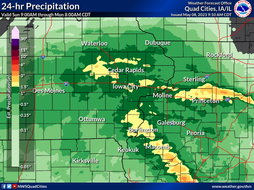
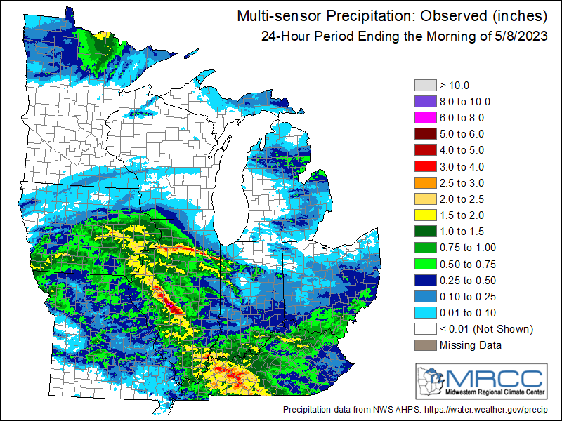
Rain Reports
| Local Rainfall Map | MRCC Regional Rainfall Map |
 |
 |
|
24 hour precipitation reports (in Inches), for |
|
|
....IOWA.... |
....ILLINOIS.... |
Environment
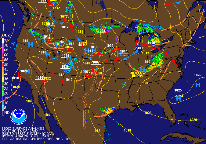
SPC Severe Weather Event: May 07, 2023
| 1630Z SPC Day 1 Categorical Outlook | 1630Z SPC Day 1 Tornado Outlook | 1630Z SPC Day 1 Hail Outlook | 1630Z SPC Day 1 Wind Outlook |
 |
 |
 |
 |
| Mesoscale Discussion 710 | Mesoscale Discussion 713 | SVA 198 | Mesoscale Discussion 719 |
 |
 |
 |
 |
 |
Media use of NWS Web News Stories is encouraged! Please acknowledge the NWS as the source of any news information accessed from this site. |
|