Overview
|
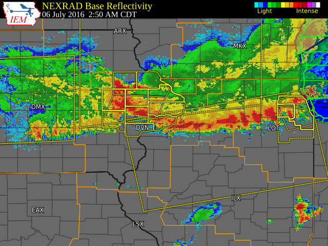
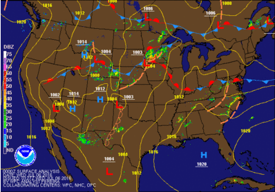
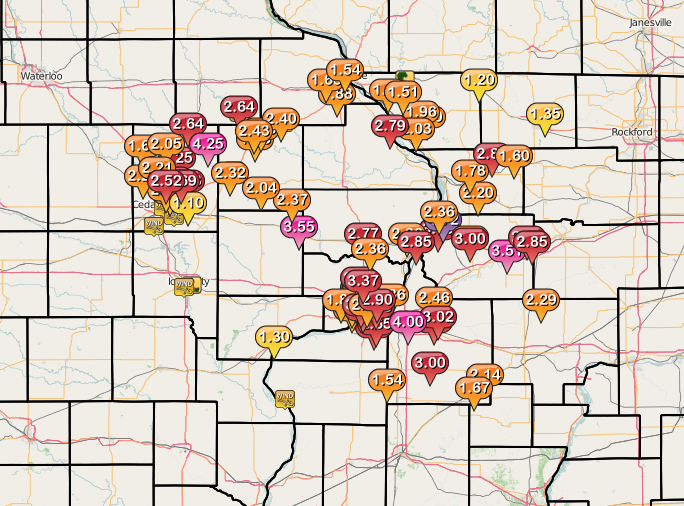
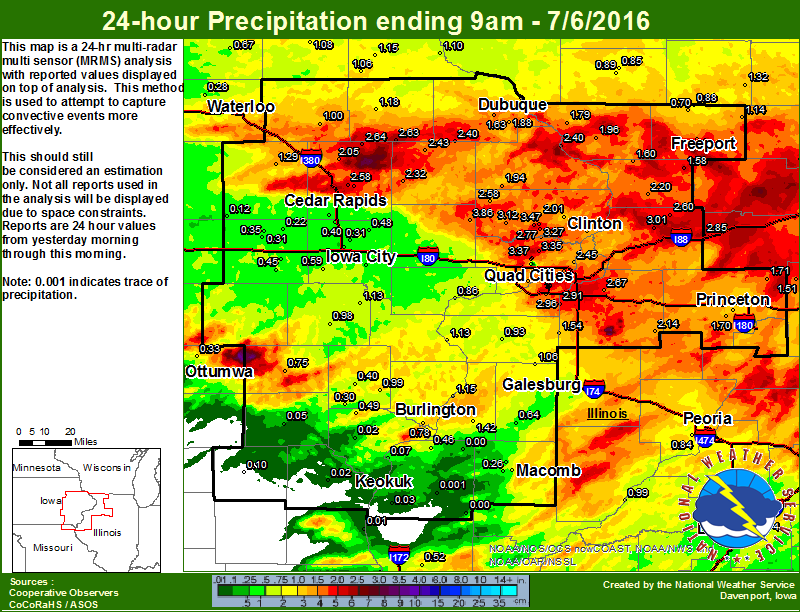
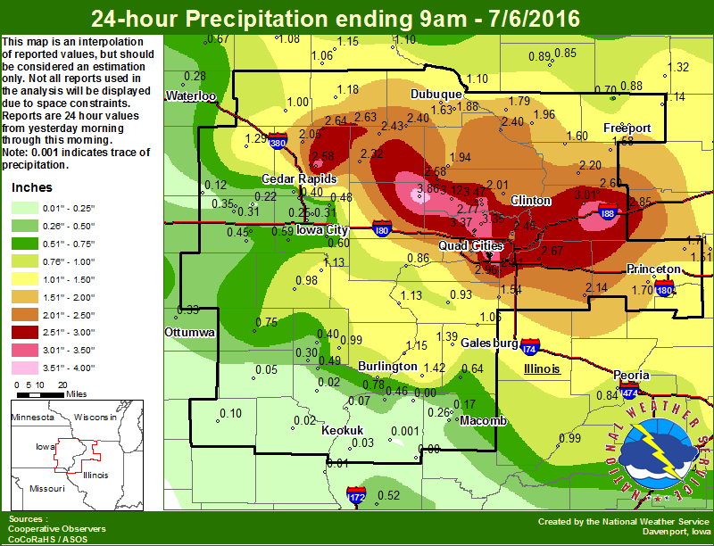
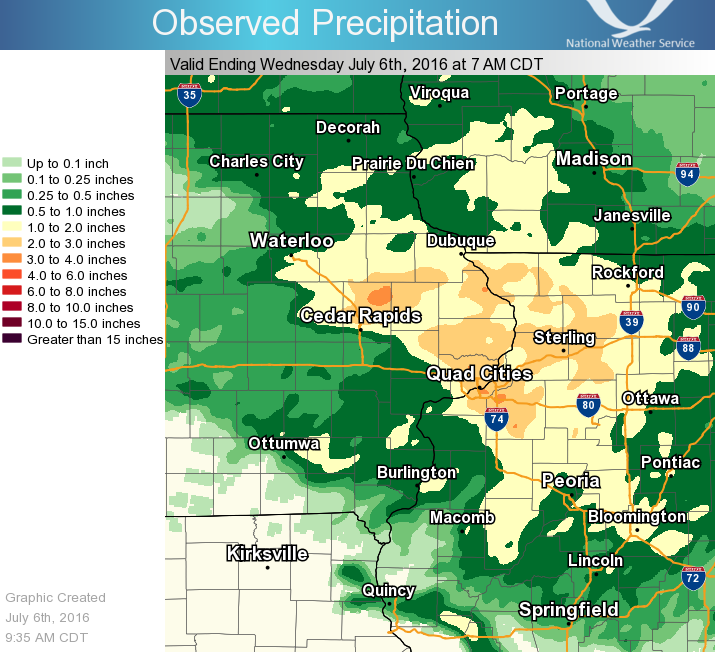
Scattered showers and thunderstorms tracked across eastern Iowa and northwest Illinois during the early morning hours of July 6, as a cold front slowly dropped south over Iowa. By 7 am, the front was bisecting the state of Iowa from southwest to northeast. The storms brought heavy rain, frequent lightning, and strong winds of 40 to 70 mph to the area. The heaviest rain fell north of a line from Cedar Rapids, to Clarence, to the Quad Cities; where 1.5 to 4 inches was recorded. Temperatures during the overnight hours were mainly in the mid 60s to lower 70s, with lows between 65 and 70.
|
 |
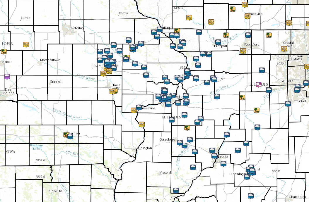
Storm Reports
Local Storm Report Map |
Interactive Regional Storm Report Map |
SPC Filtered Storm Reports 7am 07/05 to 7am 7/6 |
 |
 |
 |
PRELIMINARY LOCAL STORM REPORT...SUMMARY
NATIONAL WEATHER SERVICE QUAD CITIES IA IL
454 AM CDT WED JUL 06 2016

..TIME...   ...EVENT...      ...CITY LOCATION...     ...LAT.LON...
..DATE...   ....MAG....      ..COUNTY LOCATION..ST.. ...SOURCE....
            ..REMARKS..

1235 AM     TSTM WND DMG     3 E GALENA              42.42N 90.37W
07/06/2016                   JO DAVIESS         IL   LAW ENFORCEMENT

            TREES DOWN NEAR GUILFORD ROAD AND STAGECOACH TRAIL. TIME
            ESTIMATED.

1235 AM     TSTM WND DMG     6 NE GALENA             42.48N 90.34W
07/06/2016                   JO DAVIESS         IL   LAW ENFORCEMENT

            TREES REPORTED DOWN NEAR COUNCIL HILL ROAD AND W EAST
            ROAD. TIME ESTIMATED.

0232 AM     TSTM WND GST     1 SE CEDAR RAPIDS       41.96N 91.66W
07/06/2016  E60.00 MPH       LINN               IA   TRAINED SPOTTER

            55 TO 60 MPH WINDS, POWER OUT AT RESIDENCE.

0235 AM     TSTM WND GST     CEDAR RAPIDS MUNICIPAL  41.88N 91.72W
07/06/2016  M63.00 MPH       LINN               IA   ASOS

0243 AM     TSTM WND DMG     2 SE IOWA CITY          41.64N 91.51W
07/06/2016                   JOHNSON            IA   TRAINED SPOTTER

            SEVERAL 4 INCH TREE BRANCHES DOWN AROUND
            NEIGHBORHOOD...TIME ESTIMATED FROM RADAR.

0247 AM     TSTM WND GST     3 NNW ELY               41.92N 91.61W
07/06/2016  M62.00 MPH       LINN               IA   MESONET

0249 AM     TSTM WND GST     IOWA CITY MUNICIPAL AIR 41.63N 91.55W
07/06/2016  M59.00 MPH       JOHNSON            IA   ASOS

0252 AM     TSTM WND DMG     ANAMOSA                 42.11N 91.28W
07/06/2016                   JONES              IA   EMERGENCY MNGR

            LARGE TREE DOWN ACROSS ROAD NEAR NORTH FORD AND EAST
            LIBERTY STREETS...TIME ESTIMATED FROM RADAR.

0255 AM     TSTM WND DMG     MONTICELLO              42.24N 91.19W
07/06/2016                   JONES              IA   PUBLIC

            SEVERAL TREE LIMBS DOWN WITHIN TOWN...ONE LARGE TREE
            NORTH OF TOWN ON HWY 38 BROKE OFF AT GROUND
            LEVEL...RELAYED BY KCRG.

0257 AM     TSTM WND DMG     HOPKINTON               42.34N 91.25W
07/06/2016                   DELAWARE           IA   EMERGENCY MNGR

            LARGE TREE DOWN IN TOWN BLOCKING THE ROAD...TIME
            ESTIMATED FROM RADAR.

0303 AM     TSTM WND GST     2 ESE DAVENPORT         41.55N 90.57W
07/06/2016  M45.00 MPH       SCOTT              IA   MESONET

0307 AM     TSTM WND DMG     CASCADE                 42.30N 91.01W
07/06/2016                   DUBUQUE            IA   TRAINED SPOTTER

            MULTIPLE TREES AND POWER LINES DOWN WITHIN TOWN...TIME
            ESTIMATED FROM RADAR.

0307 AM     TSTM WND GST     CASCADE                 42.30N 91.01W
07/06/2016  E70.00 MPH       DUBUQUE            IA   TRAINED SPOTTER

            TIME ESTIMATED FROM RADAR.

0340 AM     TSTM WND GST     NEW BOSTON              41.17N 91.00W
07/06/2016  M50.00 MPH       MERCER             IL   MESONET

            MEASURED AT LOCK DAM 17

0402 AM     HEAVY RAIN       LOWDEN                  41.86N 90.92W
07/06/2016  M3.55 INCH       CEDAR              IA   CO-OP OBSERVER

            RAIN FELL ALL IN THE PAST 2 HOURS.

0402 AM     HEAVY RAIN       3 ESE DAVENPORT         41.54N 90.55W
07/06/2016  M2.14 INCH       SCOTT              IA   TRAINED SPOTTER

            RAIN FELL IN PAST HOUR.

0440 AM     HEAVY RAIN       NW DAVENPORT            41.56N 90.60W
07/06/2016  E2.00 INCH       SCOTT              IA   PUBLIC

            RAINFALL TOTAL SO FAR...REPORT VIA FACEBOOK.
PRELIMINARY LOCAL STORM REPORT...SUMMARY
NATIONAL WEATHER SERVICE QUAD CITIES IA IL
959 AM CDT WED JUL 6 2016

..TIME...   ...EVENT...      ...CITY LOCATION...     ...LAT.LON...
..DATE...   ....MAG....      ..COUNTY LOCATION..ST.. ...SOURCE....
            ..REMARKS..

0307 AM     TSTM WND GST     CASCADE                 42.30N 91.01W
07/06/2016  E70 MPH          DUBUQUE            IA   TRAINED SPOTTER

            TIME ESTIMATED FROM RADAR.

0235 AM     TSTM WND GST     CEDAR RAPIDS MUNICIPALI 41.88N 91.72W
07/06/2016  M63 MPH          LINN               IA   ASOS


0247 AM     TSTM WND GST     3 NNW ELY               41.92N 91.61W
07/06/2016  M62 MPH          LINN               IA   MESONET


0232 AM     TSTM WND GST     1 SSE CEDAR RAPIDS      41.96N 91.66W
07/06/2016  E60 MPH          LINN               IA   TRAINED SPOTTER

            55 TO 60 MPH WINDS, POWER OUT AT RESIDENCE.

0249 AM     TSTM WND GST     IOWA CITY MUNICIPALITY  41.63N 91.55W
07/06/2016  M59 MPH          JOHNSON            IA   ASOS


0340 AM     TSTM WND GST     NEW BOSTON              41.17N 91.00W
07/06/2016  M50 MPH          MERCER             IL   MESONET

            MEASURED AT LOCK DAM 17.

0303 AM     TSTM WND GST     2 ESE DAVENPORT         41.55N 90.57W
07/06/2016  M45 MPH          SCOTT              IA   MESONET


0725 AM     HEAVY RAIN       2 NE FULTON             41.89N 90.13W
07/06/2016  M4.72 INCH       WHITESIDE          IL   TRAINED SPOTTER

            STORM TOTAL IN APPROXIMATELY THE PAST 6
            HOURS.

0730 AM     HEAVY RAIN       3 S PRAIRIEBURG         42.20N 91.42W
07/06/2016  M4.25 INCH       LINN               IA   MESONET

            MESONET STATION BUFFALO CRK AT PRAIRIEBURG
            /PRAI4/.

0811 AM     HEAVY RAIN       1 E GREEN RIVER         41.47N 90.32W
07/06/2016  M4.00 INCH       HENRY              IL   TRAINED SPOTTER

            STORM TOTAL.

0402 AM     HEAVY RAIN       LOWDEN                  41.86N 90.92W
07/06/2016  M3.55 INCH       CEDAR              IA   CO-OP OBSERVER

            RAIN FELL ALL IN THE PAST 2 HOURS.

0811 AM     HEAVY RAIN       ELDRIDGE                41.64N 90.57W
07/06/2016  M3.37 INCH       SCOTT              IA   COCORAHS

            RAINFALL TOTAL SINCE 215 AM.

0611 AM     HEAVY RAIN       2 ESE ALBURNETT         42.14N 91.59W
07/06/2016  M3.25 INCH       LINN               IA   PUBLIC

            STORM TOTAL...RELAYED VIA KCRG.

0731 AM     HEAVY RAIN       2 SE DAVENPORT          41.54N 90.58W
07/06/2016  M3.16 INCH       SCOTT              IA   TRAINED SPOTTER


0711 AM     HEAVY RAIN       1 NNW MARION AIRPORT    42.05N 91.54W
07/06/2016  M3.03 INCH       LINN               IA   TRAINED SPOTTER


0730 AM     HEAVY RAIN       3 N GENESEO             41.49N 90.16W
07/06/2016  M3.02 INCH       HENRY              IL   MESONET

            MESONET STATION GREEN RVR AT GENESEO
            /GENI2/.

0807 AM     HEAVY RAIN       CAMBRIDGE               41.30N 90.20W
07/06/2016  M3.00 INCH       HENRY              IL   TRAINED SPOTTER


0811 AM     HEAVY RAIN       UNIONVILLE              41.81N 89.98W
07/06/2016  M3.00 INCH       WHITESIDE          IL   TRAINED SPOTTER

            STORM TOTAL.

0754 AM     HEAVY RAIN       1 WSW BETTENDORF        41.56N 90.49W
07/06/2016  M2.90 INCH       SCOTT              IA   TRAINED SPOTTER


0803 AM     HEAVY RAIN       3 E STERLING            41.80N 89.64W
07/06/2016  M2.85 INCH       WHITESIDE          IL   CO-OP OBSERVER

            STORM TOTAL.

0917 AM     HEAVY RAIN       4 NNW LANARK            42.16N 89.86W
07/06/2016  M2.80 INCH       CARROLL            IL   TRAINED SPOTTER


0730 AM     HEAVY RAIN       2 W BLANDING            42.27N 90.42W
07/06/2016  M2.79 INCH       JO DAVIESS         IL   MESONET

            MESONET STATION BELLEVUE L/D 12 /BLVI4/.

0700 AM     HEAVY RAIN       1 WSW MARION            42.03N 91.61W
07/06/2016  M2.78 INCH       LINN               IA   MESONET

            MESONET STATION INDIAN CRK AT MARION
            /MRNI4/.

0730 AM     HEAVY RAIN       3 ENE CREDIT ISLAND     41.52N 90.57W
07/06/2016  M2.75 INCH       SCOTT              IA   CO-OP OBSERVER

            CO-OP OBSERVER STATION ROCK ISLAND L/D 15
            /RCKI2/.

0711 AM     HEAVY RAIN       DAVENPORT               41.56N 90.61W
07/06/2016  M2.73 INCH       SCOTT              IA   TRAINED SPOTTER


0725 AM     HEAVY RAIN       1 NE MARION             42.05N 91.57W
07/06/2016  M2.69 INCH       LINN               IA   MESONET

            MESONET STATION 1 ENE MARION /D8270/.

0736 AM     HEAVY RAIN       2 WSW RIVERDALE         41.53N 90.50W
07/06/2016  M2.66 INCH       SCOTT              IA   MESONET

            MESONET STATION 1 W RIVERDALE /C6804/.

0730 AM     HEAVY RAIN       1 N MOLINE QUAD-CITY AI 41.46N 90.50W
07/06/2016  M2.65 INCH       ROCK ISLAND        IL   MESONET

            MESONET STATION ROCK RVR AT MOLINE /MLII2/.

0736 AM     HEAVY RAIN       2 E HIAWATHA            42.05N 91.65W
07/06/2016  M2.52 INCH       LINN               IA   MESONET

            MESONET STATION 1 E HIAWATHA /D2681/.

0739 AM     HEAVY RAIN       2 NE STERLING           41.82N 89.67W
07/06/2016  M2.50 INCH       WHITESIDE          IL   MESONET

            MESONET STATION 1 NE STERLING /D4895/.

0727 AM     HEAVY RAIN       1 NW ELDRIDGE           41.65N 90.59W
07/06/2016  M2.50 INCH       SCOTT              IA   MESONET

            MESONET STATION 1 WNW ELDRIDGE /D9509/.

0730 AM     HEAVY RAIN       3 NNE SHADY BEACH       41.57N 90.18W
07/06/2016  M2.46 INCH       ROCK ISLAND        IL   MESONET

            MESONET STATION ROCK RVR NEAR JOSLIN
            /JOSI2/.

0614 AM     HEAVY RAIN       3 NE MONTICELLO MUNICIP 42.26N 91.13W
07/06/2016  M2.40 INCH       JONES              IA   TRAINED SPOTTER

            STORM TOTAL...FELL IN 5 HOURS.

0730 AM     HEAVY RAIN       OXFORD MILLS            41.97N 90.96W
07/06/2016  M2.37 INCH       JONES              IA   MESONET

            MESONET STATION WAPSI RVR AT OXFORD JCT
            /OXJI4/.

0738 AM     HEAVY RAIN       3 ESE DAVENPORT         41.54N 90.55W
07/06/2016  M2.36 INCH       SCOTT              IA   MESONET

            MESONET STATION 2 ESE DAVENPORT /D3903/.

0730 AM     HEAVY RAIN       4 SW THOMSON            41.92N 90.15W
07/06/2016  M2.36 INCH       WHITESIDE          IL   MESONET

            MESONET STATION FULTON L/D 13 /FLTI2/.

0730 AM     HEAVY RAIN       1 N PLEASANT VALLEY     41.58N 90.42W
07/06/2016  M2.36 INCH       SCOTT              IA   CO-OP OBSERVER

            CO-OP OBSERVER STATION LE CLAIRE L/D 14
            /LECI4/.

0730 AM     HEAVY RAIN       4 SSE DEWITT            41.77N 90.53W
07/06/2016  M2.36 INCH       SCOTT              IA   MESONET

            MESONET STATION WAPSI RVR AT DEWITT /DEWI4/.

0730 AM     HEAVY RAIN       WALNUT                  41.56N 89.59W
07/06/2016  M2.29 INCH       BUREAU             IL   MESONET

            MESONET STATION WALNUT /D9555/.

0715 AM     HEAVY RAIN       1 ENE PALO              42.07N 91.78W
07/06/2016  M2.29 INCH       LINN               IA   MESONET

            MESONET STATION CEDAR RVR NEAR PALO /PLOI4/.

0736 AM     HEAVY RAIN       UNIONVILLE              41.82N 89.98W
07/06/2016  M2.27 INCH       WHITESIDE          IL   MESONET

            MESONET STATION UNIONVILLE /E1961/.

0609 AM     HEAVY RAIN       3 NNE CEDAR RAPIDS      42.01N 91.65W
07/06/2016  M2.26 INCH       LINN               IA   TRAINED SPOTTER

            STORM TOTAL.

0735 AM     HEAVY RAIN       MIDWAY                  42.10N 91.70W
07/06/2016  M2.21 INCH       LINN               IA   MESONET

            MESONET STATION MIDWAY /AV079/.

0655 AM     HEAVY RAIN       2 NNW CREDIT ISLAND     41.52N 90.63W
07/06/2016  M2.20 INCH       SCOTT              IA   TRAINED SPOTTER

            STORM TOTAL...PAST 6 HOURS.

0402 AM     HEAVY RAIN       3 ESE DAVENPORT         41.54N 90.55W
07/06/2016  M2.14 INCH       SCOTT              IA   TRAINED SPOTTER

            RAIN FELL IN PAST HOUR.

0735 AM     HEAVY RAIN       2 NNE OLIN              42.02N 91.13W
07/06/2016  M2.04 INCH       JONES              IA   MESONET

            MESONET STATION 1 NNE OLIN /D2485/.

0440 AM     HEAVY RAIN       DAVENPORT               41.56N 90.60W
07/06/2016  E2.00 INCH       SCOTT              IA   PUBLIC

            RAINFALL TOTAL SO FAR...REPORT VIA FACEBOOK.

0715 AM     HEAVY RAIN       3 N WEST LAKE PARK      41.56N 90.69W
07/06/2016  M1.85 INCH       SCOTT              IA   MESONET

            MESONET STATION DUCK CRK NEAR WEST LAKE
            /WLCI4/.

0630 AM     HEAVY RAIN       ELIZABETH               42.31N 90.22W
07/06/2016  M1.80 INCH       JO DAVIESS         IL   TRAINED SPOTTER

            STORM TOTAL...PAST 6 HOURS.

0736 AM     HEAVY RAIN       MOUNT CARROLL           42.09N 89.98W
07/06/2016  M1.78 INCH       CARROLL            IL   MESONET

            MESONET STATION MOUNT CARROLL /C0216/.

0738 AM     HEAVY RAIN       KEWANEE MUNICIPAL       41.20N 89.96W
07/06/2016  M1.67 INCH       HENRY              IL   MESONET

            MESONET STATION KEWANEE MUNICIPAL /D7642/.

0736 AM     HEAVY RAIN       2 SSE JULIEN            42.46N 90.77W
07/06/2016  M1.63 INCH       DUBUQUE            IA   MESONET

            MESONET STATION 1 SSE JULIEN /D9981/.

0924 AM     HEAVY RAIN       SHANNON                 42.15N 89.74W
07/06/2016  M1.60 INCH       CARROLL            IL   TRAINED SPOTTER


0737 AM     HEAVY RAIN       1 ESE DUBUQUE           42.50N 90.67W
07/06/2016  M1.54 INCH       DUBUQUE            IA   MESONET

            MESONET STATION 1 ESE DUBUQUE /D9979/.

0734 AM     HEAVY RAIN       1 NW GALENA TERRITORY   42.41N 90.35W
07/06/2016  M1.51 INCH       JO DAVIESS         IL   MESONET

            MESONET STATION GALENA TERRITORY /D7485/.

0800 AM     HEAVY RAIN       3 SW WINNESHIEK         42.32N 89.57W
07/06/2016  M1.35 INCH       STEPHENSON         IL   TRAINED SPOTTER

            STORM TOTAL SINCE MIDNIGHT.

0720 AM     HEAVY RAIN       1 SE MUSCATINE          41.41N 91.06W
07/06/2016  M1.30 INCH       MUSCATINE          IA   TRAINED SPOTTER

            STORM TOTAL PAST 6 HOURS.

0723 AM     HEAVY RAIN       BERTRAM                 41.96N 91.53W
07/06/2016  M1.10 INCH       LINN               IA   TRAINED SPOTTER


1235 AM     TSTM WND DMG     2 NW GALENA TERRITORY   42.42N 90.37W
07/06/2016                   JO DAVIESS         IL   LAW ENFORCEMENT

            TREES DOWN NEAR GUILFORD ROAD AND STAGECOACH
            TRAIL. TIME ESTIMATED.

1235 AM     TSTM WND DMG     1 ESE COUNCIL HILL      42.48N 90.34W
07/06/2016                   JO DAVIESS         IL   LAW ENFORCEMENT

            TREES REPORTED DOWN NEAR COUNCIL HILL ROAD
            AND W EAST ROAD. TIME ESTIMATED.

0243 AM     TSTM WND DMG     2 SE IOWA CITY          41.64N 91.51W
07/06/2016                   JOHNSON            IA   TRAINED SPOTTER

            SEVERAL 4 INCH TREE BRANCHES DOWN AROUND
            NEIGHBORHOOD...TIME ESTIMATED FROM RADAR.

0252 AM     TSTM WND DMG     ANAMOSA                 42.11N 91.28W
07/06/2016                   JONES              IA   EMERGENCY MNGR

            LARGE TREE DOWN ACROSS ROAD NEAR NORTH FORD
            AND EAST LIBERTY STREETS...TIME ESTIMATED
            FROM RADAR.

0255 AM     TSTM WND DMG     MONTICELLO              42.24N 91.19W
07/06/2016                   JONES              IA   PUBLIC

            SEVERAL TREE LIMBS DOWN WITHIN TOWN...ONE
            LARGE TREE NORTH OF TOWN ON HWY 38 BROKE OFF
            AT GROUND LEVEL...RELAYED BY KCRG.

0257 AM     TSTM WND DMG     HOPKINTON               42.34N 91.25W
07/06/2016                   DELAWARE           IA   EMERGENCY MNGR

            LARGE TREE DOWN IN TOWN BLOCKING THE
            ROAD...TIME ESTIMATED FROM RADAR.

0307 AM     TSTM WND DMG     CASCADE                 42.30N 91.01W
07/06/2016                   DUBUQUE            IA   TRAINED SPOTTER

            MULTIPLE TREES AND POWER LINES DOWN WITHIN
            TOWN...TIME ESTIMATED FROM RADAR.
Rain Reports
| Local Rainfall | Local Rainfall | Regional Rainfall |
 |
 |
 |
MAX/MIN TEMPERATURE AND PRECIPITATION TABLE FOR
EASTERN IA/NORTHWESTERN IL/NORTHEASTERN MO
NATIONAL WEATHER SERVICE QUAD CITIES IA IL
857 AM CDT WED JUL 6 2016

Values represent highs yesterday...lows over the last 12 hours
and 24-hour precipitation ending at 7 AM central time.

.BR DVN 0706 C DH01/TAIRZX/DH07/TAIRZP/PPDRZZ/SFDRZZ/SDIRZZ
:
:                           Max   Min           Snow   Snow
:ID     Location            Temp  Temp   Pcpn   Fall   Depth
:
:ASOS Sites
BRL  : Burlington Arpt    :  87 /  68 /  0.85 /    M /   M
CID  : Cedar Rapids Arpt  :  86 /  68 /  0.33 /    M /   M
DVN  : Davenport Arpt     :  85 /  67 /  2.99 /  0.0 /   0
DBQ  : Dubuque Arpt       :  83 /  66 /  1.88 /  0.0 /   0
IOW  : Iowa City Arpt     :  87 /  69 /  0.44 /    M /   M
MLI  : Quad City Arpt     :  87 /  70 /  2.96 /  0.0 /   0
:
:AWOS Sites--Data provided by NWS partners
CWI  : Clinton Arpt       :  86 /  66 /       /      /
FFL  : Fairfield Arpt     :  90 /  68 /       /      /
FEP  : Freeport Arpt      :  84 /  65 /       /      /
IIB  : Independence Arpt  :  86 /  66 /       /      /
EOK  : Keokuk Arpt        :  88 /  70 /       /      /
MQB  : Macomb Arpt        :  85 /  67 /       /      /
MXO  : Monticello Arpt    :  84 /  68 /       /      /
MUT  : Muscatine Arpt     :  88 /  70 /       /      /
SQI  : Sterling Arpt      :  86 /  68 /       /      /
VTI  : Vinton Arpt        :  91 /  71 /       /      /
AWG  : Washington Arpt    :  88 /  68 /       /      /
.END


Cooperative Observations
Values are for the previous 24 hours
.BR DVN 0706 C DH07/TAIRZX/TAIRZN/PPDRZZ/SFDRZZ/SDIRZZ
:
:       Station             Obs     Max   Min           Snow  Snow
:ID     Name                Time    Temp  Temp   Pcpn   Fall  Depth
:
:Northeast Iowa...
:
CASI4: Cascade            : DH0700/  85 /  66 /  2.40 /  0.0 /   0
DLDI4: Dubuque L&D11      : DH0600/  87 /  69 /  1.10 /      /
MHRI4: Manchester #2      : DH0700/  84 /  65 /  1.18 /  0.0 /   0
:
:East Central Iowa...
:
AMOI4: Anamosa 3SSW       : DH0600/  84 /  66 /  2.32 /  0.0 /   0
BLLI4: Belle Plaine       : DH0700/  87 /  67 /  0.12 /  0.0 /   0
BLVI4: Bellevue L&D12     : DH0600/  86 /  68 /  2.40 /      /
CGGI4: Coggon             : DH0630/  85 /  66 /  2.64 /      /
DVNI4: Davenport NWS      : DH0700/     /     /  2.93 /  0.0 /   0
DWTI4: De Witt            : DH0800/     /     /  3.40 /      /
DEWI4: De Witt 4S         : DH0700/     /     /  3.27 /  0.0 /   0
ICYI4: Iowa City          : DH0700/  87 /  66 /  0.60 /  0.0 /   0
LECI4: Le Claire L&D14    : DH0600/  89 /  67 /  2.55 /      /
LWDI4: Lowden             : DH0700/     /     /  3.86 /  0.0 /   0
MKTI4: Maquoketa 4W       : DH0700/  84 /  67 /  1.94 /  0.0 /   0
MROI4: Marengo 2ESE       : DH0700/     /     /  0.31 /      /
MCLI4: Monticello         : DH0731/     /     /  2.43 /      /
SWHI4: Swisher            : DH0700/     /     /  0.40 /      /
VNTI4: Vinton             : DH0700/  86 /  67 /  1.29 /  0.0 /   0
WLBI4: Williamsburg       : DH0630/  89 /  67 /  0.61 /  0.0 /   0
:
:Southeast Iowa...
:
DNNI4: Donnellson         : DH0700/  89 /  68 /  0.02 /      /
EOKI4: Keokuk L&D19       : DH0600/  88 /  66 /  0.00 /      /
FRFI4: Fairfield          : DH0800/  89 /  67 /  0.75 /  0.0 /   0
KEQI4: Keosauqua          : DH0700/  89 /  70 /  0.05 /  0.0 /   0
MPZI4: Mt Pleasant        : DH0700/  88 /  62 /  0.40 /      /
SLHI4: Salem 1S           : DH0700/     /     /  0.30 /  0.0 /   0
SGYI4: Sigourney          : DH0700/  90 /  67 /  0.55 /  0.0 /   0
WSHI4: Washington         : DH0651/  89 /  65 /  0.98 /  0.0 /   0
:
:Northwest Illinois...
:
ALEI2: Aledo              : DH0700/  87 /  67 /  0.93 /  0.0 /   0
EZBI2: Elizabeth 5S       : DH0630/  84 /  67 /  1.96 /      /
FEEI2: Freeport           : DH0700/  84 /  66 /  1.45 /      /
GPBI2: Galena             : DH0700/  83 /  66 /  1.79 /  0.0 /   0
ILNI2: Illinois City L&D16: DH0600/  88 /  63 /  0.86 /      /
KEWI2: Kewanee 1E         : DH0700/  84 /  66 /  2.14 /  0.0 /   0
NBOI2: New Boston L&D17   : DH0600/  86 /  68 /  1.13 /      /
RCFI2: Rock Falls         : DH0700/     /     /  2.85 /  0.0 /   0
:
:Western Illinois...
:
ALXI2: Alexis             : DH0715/     /     /  1.06 /      /
AUGI2: Augusta            : DH0539/     /     /  0.00 /  0.0 /   0
BTYI2: Bentley            : DH0645/  89 /  64 /    T  /      /
GLDI2: Gladstone L&D18    : DH0800/  85 /  66 /  1.15 /  0.0 /   0
LAHI2: La Harpe           : DH0500/  89 /  63 /  0.00 /      /
MMTI2: Monmouth 4NW       : DH0800/  86 /  67 /  1.39 /      /
:
:Northeast Missouri...
:
MMPM7: Memphis            : DH0600/  90 /  62 /  0.10 /  0.0 /   0
.END
These data are preliminary and have not undergone final quality
control by the National Climatic Data Center (NCDC).
Therefore...these data are subject to revision.  Final and
certified climate data can be accessed at www.ncdc.noaa.gov.
COCORAHS PRECIPITATION SUMMARY
NATIONAL WEATHER SERVICE QUAD CITIES IA IL
844 AM CDT WED JUL 6 2016

...COCORAHS PRECIPITATION REPORTS...

THESE REPORTS ARE CONSIDERED SUPPLEMENTAL AND UNOFFICIAL
VALUES ARE FOR THE PREVIOUS 24 HOURS ENDING AROUND 7 AM LOCAL TIME

FOR MORE INFORMATION ON THE COCORAHS PROGRAM PLEASE VISIT
WWW.COCORAHS.ORG

.B DVN 0706 C DH07/PP/SF/SD/SW
:
:COCORAHS PRECIPITATION REPORTS IN ILLINOIS
:
:                                               SNOW   SNOW  WATER
:                                        PCPN   FALL  DEPTH  EQUIV
:
IL-RI-3   : MOLINE 0.9 N             *   : 3.88 /  MM /   MM /   MM
IL-RI-13  : MOLINE 0.7 NNE           *   : 3.86 /  MM /   MM /   MM
IL-RI-10  : MOLINE 1.1 N             *   : 3.63 /  MM /   MM /   MM
IL-WD-14  : STERLING 4.9 WSW         *   : 3.51 /  MM /   MM /   MM
IL-WD-5   : MORRISON 3.2 E           *   : 3.01 /  MM /   MM /   MM
IL-HY-1   : ORION 4.1 NW             *   : 2.91 /  MM /   MM /   MM
IL-HY-8   : GENESEO 2.0 NW           *   : 2.67 /  MM /   MM /   MM
IL-WD-8   : COLETA 1.4 SSW           *   : 2.60 /  MM /   MM /   MM
IL-CR-4   : CHADWICK 2.7 WSW         *   : 2.20 /  MM /   MM /   MM
IL-BU-9   : LA MOILLE 0.2 NNE        *   : 1.71 /  MM /   MM /   MM
IL-BU-8   : TISKILWA 2.1 N           *   : 1.70 /  MM /   MM /   MM
IL-CR-12  : MOUNT CARROLL 6.8 NNW    *   : 1.60 /  MM /   MM /   MM
IL-CR-13  : SHANNON 0.2 S            *   : 1.58 /  MM /   MM /   MM
IL-HY-6   : NEW WINDSOR 2.0 N        *   : 1.54 /  MM /   MM /   MM
IL-SP-14  : FREEPORT 1.7 ESE         *   : 1.49 /  MM /   MM /   MM
IL-HD-1   : STRONGHURST 0.4 SSW      *   : 1.42 /  MM /   MM /   MM
IL-BU-10  : PRINCETON 1.5 S          *   : 1.25 /  MM /   MM /   MM
IL-SP-6   : FREEPORT 2.0 NW          *   : 1.22 /  MM /   MM /   MM
IL-SP-7   : DAVIS 0.5 N              *   : 1.14 / 0.0 /  0.0 /   MM
IL-SP-3   : ORANGEVILLE 2.8 NW       *   : 0.88 /  MM /   MM /   MM
IL-SP-8   : WINSLOW 4.3 ESE          *   : 0.70 /  MM /   MM /   MM
IL-WR-2   : ROSEVILLE 0.6 WNW        *   : 0.64 / 0.0 /  0.0 / 0.00
IL-MCD-5  : MACOMB 0.6 WNW           *   : 0.47 /  MM /   MM /   MM
IL-HN-1   : DALLAS CITY 3.0 SSE      *   : 0.46 /  MM /   MM /   MM
IL-MCD-7  : COLCHESTER 3.5 NE        *   : 0.26 /  MM /   MM /   MM
IL-MCD-6  : MACOMB 3.8 NW            *   : 0.17 /  MM /   MM /   MM
IL-HN-5   : NAUVOO 0.7 SSE           *   : 0.07 /  MM /   MM /   MM
IL-HN-2   : WARSAW 5.8 SE            *   : 0.03 /  MM /   MM /   MM
:
:COCORAHS PRECIPITATION REPORTS IN EASTERN IOWA
:
:                                               SNOW   SNOW  WATER
:                                        PCPN   FALL  DEPTH  EQUIV
:
IA-CN-11  : DE WITT 0.9 N            *   : 3.47 /  MM /   MM /   MM
IA-ST-30  : ELDRIDGE 0.7 SSW         *   : 3.37 / 0.0 /  0.0 /   MM
IA-ST-21  : ELDRIDGE 0.6 S           *   : 3.37 /  MM /   MM /   MM
IA-ST-3   : PARK VIEW 0.2 WSW        *   : 3.35 /  MM /   MM /   MM
IA-LN-9   : MARION 1.2 NE            *   : 3.27 /  MM /   MM /   MM
IA-ST-8   : BETTENDORF 2.2 SE        *   : 3.16 / 0.0 /  0.0 /   MM
IA-CN-2   : CALAMUS 2.0 NE           *   : 3.12 /  MM /   MM /   MM
IA-CN-5   : CAMANCHE 1.2 W           *   : 2.85 /  MM /   MM /   MM
IA-CN-1   : DE WITT 1.4 WNW          *   : 2.77 /  MM /   MM /   MM
IA-DW-6   : HOPKINTON 5.4 WSW        *   : 2.63 /  MM /   MM /   MM
IA-LN-27  : MARION 1.7 NNW           *   : 2.58 /  MM /   MM /   MM
IA-CN-12  : LOST NATION 0.3 S        *   : 2.58 /  MM /   MM /   MM
IA-ST-1   : LE CLAIRE 1.8 NNE        *   : 2.45 /  MM /   MM /   MM
IA-CN-10  : CLINTON 1.7 W            *   : 2.38 /  MM /   MM /   MM
IA-ST-23  : DAVENPORT 2.1 SW         *   : 2.18 / 0.0 /  0.0 /   MM
IA-LN-7   : CENTRAL CITY 6.7 W       *   : 2.05 /  MM /   MM /   MM
IA-CN-13  : GOOSE LAKE 6.4 SSW       *   : 2.01 /  MM /   MM /   MM
IA-DB-16  : PEOSTA 2.9 E             *   : 1.63 /  MM /   MM /   MM
IA-WS-2   : AINSWORTH 7.4 N          *   : 1.13 /  MM /   MM /   MM
IA-BC-2   : QUASQUETON 0.4 WSW       *   : 1.00 / 0.0 /  0.0 /   MM
IA-HY-1   : NEW LONDON 1.5 SW        *   : 0.99 /  MM /   MM /   MM
IA-DM-8   : BURLINGTON 0.8 SSE       *   : 0.95 /  MM /   MM /   MM
IA-DM-7   : BURLINGTON 6.5 SSW       *   : 0.78 /  MM /   MM /   MM
IA-JH-9   : KALONA 7.3 NNW           *   : 0.59 /  MM /   MM /   MM
IA-LE-11  : WEST POINT 7.5 NW        *   : 0.49 /  MM /   MM /   MM
IA-JH-1   : SOLON 0.3 ESE            *   : 0.48 /  MM /   MM /   MM
IA-IA-13  : PARNELL 0.1 SSW          *   : 0.45 /  MM /   MM /   MM
IA-IA-2   : MARENGO 2.6 SSW          *   : 0.35 /  MM /   MM /   MM
IA-JH-8   : NORTH LIBERTY 1.0 ENE    *   : 0.31 /  MM /   MM /   MM
IA-JH-10  : CORALVILLE 1.8 NW        *   : 0.25 /  MM /   MM /   MM
IA-IA-6   : AMANA 4.7 W              *   : 0.22 /  MM /   MM /   MM
IA-LE-7   : KEOKUK 0.6 NE            *   : 0.10 /  MM /   MM /   MM
:
:COCORAHS PRECIPITATION REPORTS IN NORTHEAST MISSOURI
:
:                                               SNOW   SNOW  WATER
:                                        PCPN   FALL  DEPTH  EQUIV
:
MO-FSA-045: KAHOKA 0.6 S             *   : 0.02 /  MM /   MM /   MM
Environment
| Local Info | Weather Story (428pm) | |||
|
|
 |
|||
|
|
||||
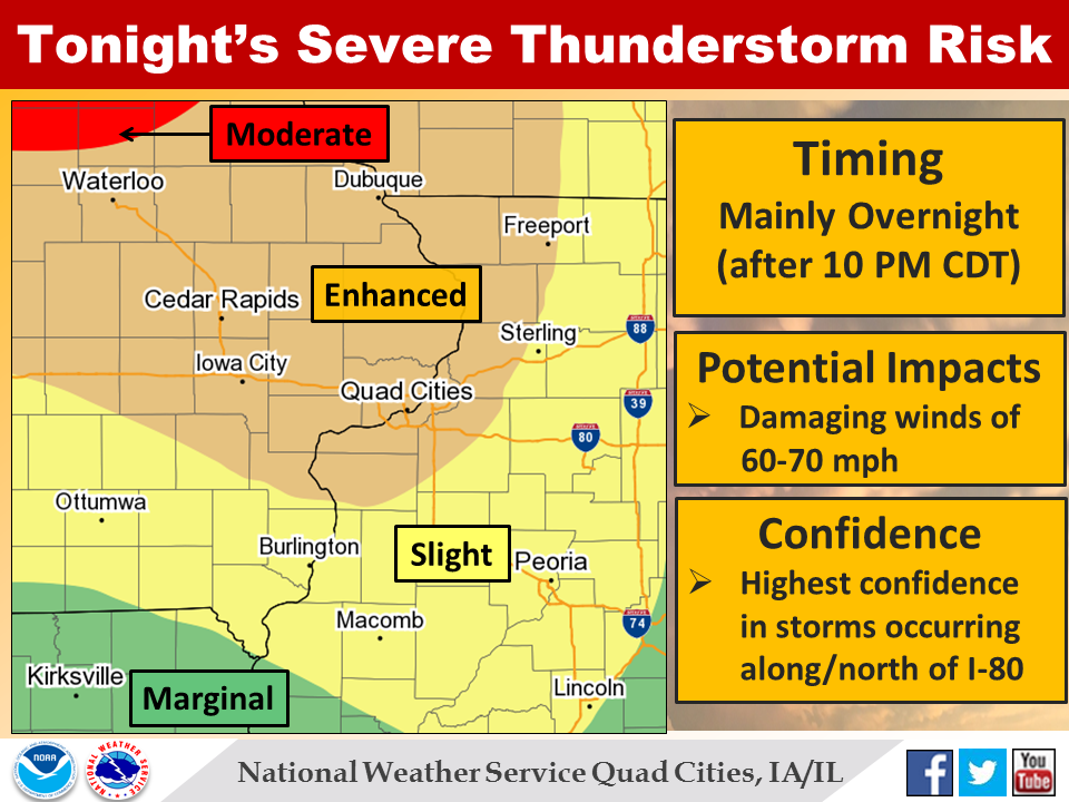
| Storm Prediction Center | ||||
 |
 |
 |
||
| SPC DAY1 Issued at 256 pm 7/5/2016 |
Day 1 with Storm Reports | SPC Mesoscale Discussion 1154 | ||
 |
 |
 |
||
| Severe Thunderstorm Watch 331 | SPC Mesoscale Discussion 1157 | SPC Mesoscale Discussion 1159 | ||
 |
 |
|||
| Severe Thunderstorm Watch 333 | SPC Mesoscale Discussion 1162 | |||
 |
Media use of NWS Web News Stories is encouraged! Please acknowledge the NWS as the source of any news information accessed from this site. |
|