 |
 |
||
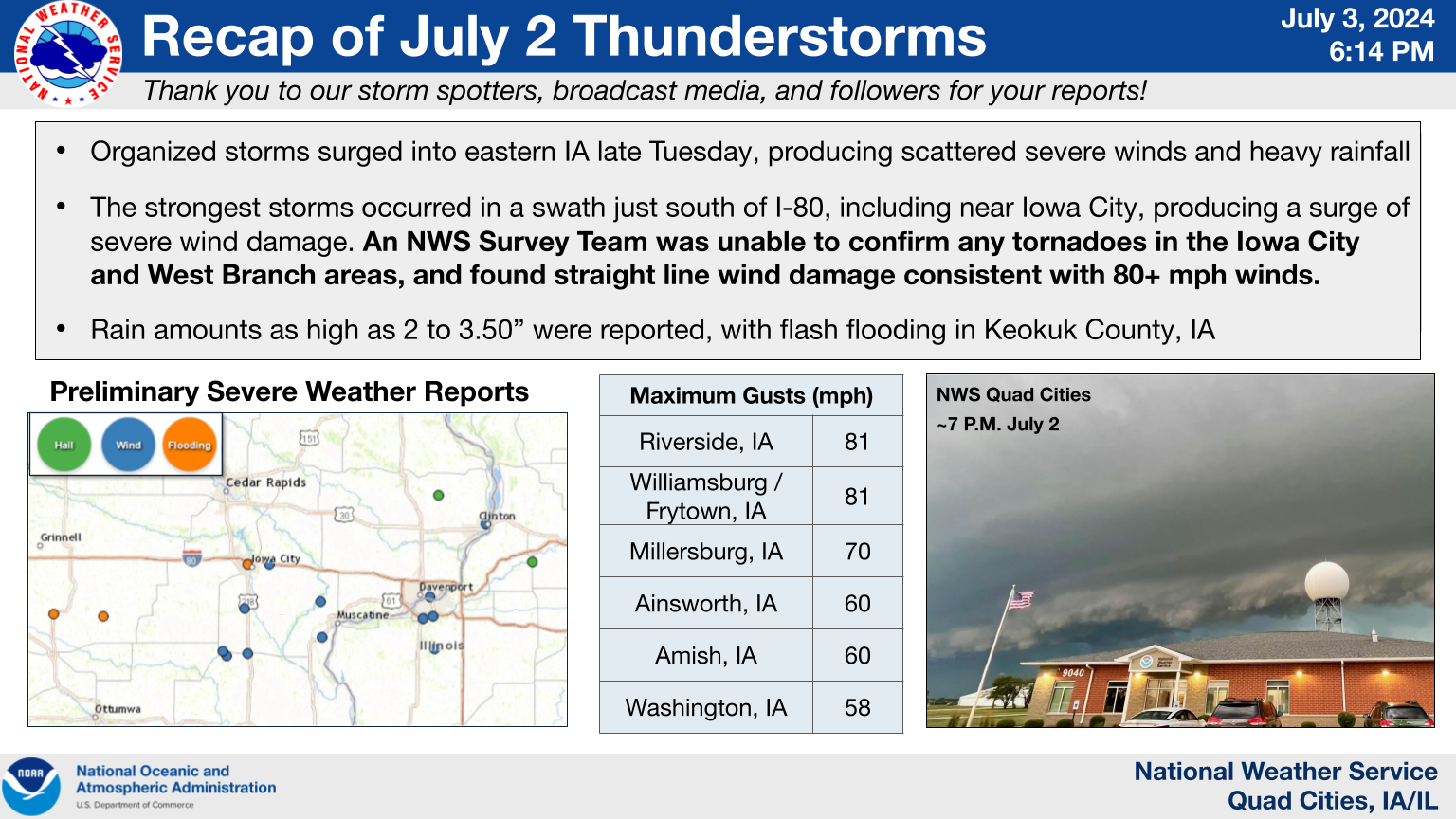
| Event Summary |
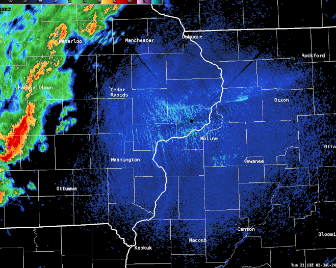
NWS Quad Cities Radar Loop: July 2, 4-8 PM |
||
| IEM Radar Loop |
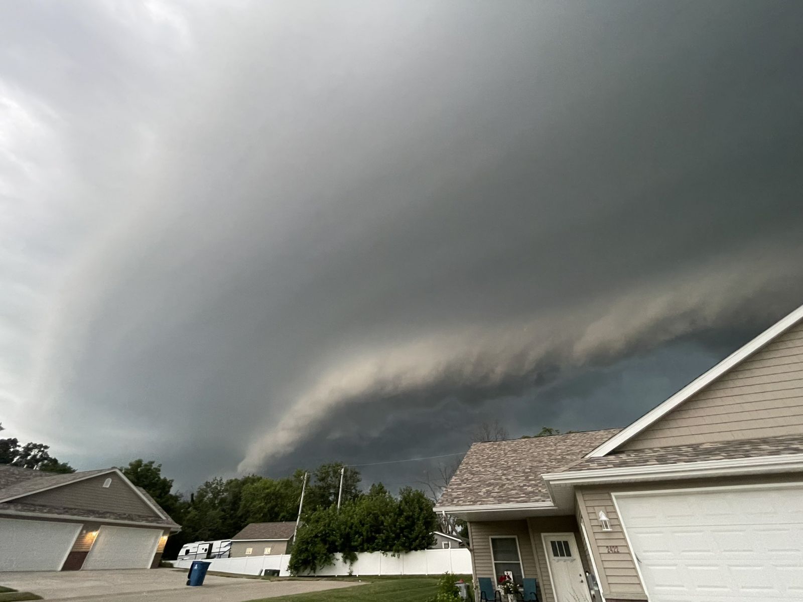
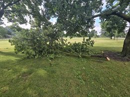
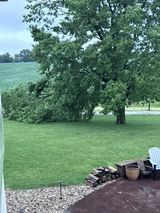
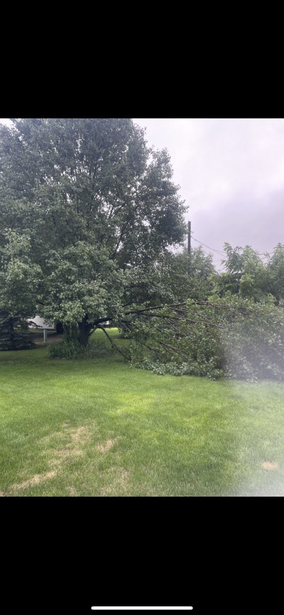
Photos
 |
 |
 |
|
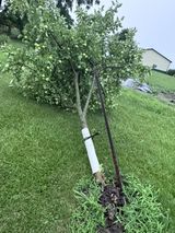
Fruit tree toppled over four miles east of West Branch, IA. Courtesy of Jennifer Falco Van Hall. |
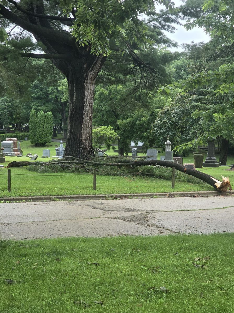
Large tree branch down in Sterling, IL. Courtesy of Jerrica Watson. |
Shelf cloud approaching Silvis, IL. Courtesy of Melissa Gallagher. |
 |
 |
 |
|
Large tree branch down at Meier Park in Bettendorf, IA. Courtesy of Dave Goetsch. |
Large tree branch down four miles east of West Branch, IA. Courtesy of Jennifer Falco Van Hall. |
Large tree branch down in Muscatine. Courtesy of Parker. |
 |
 |
 |
|
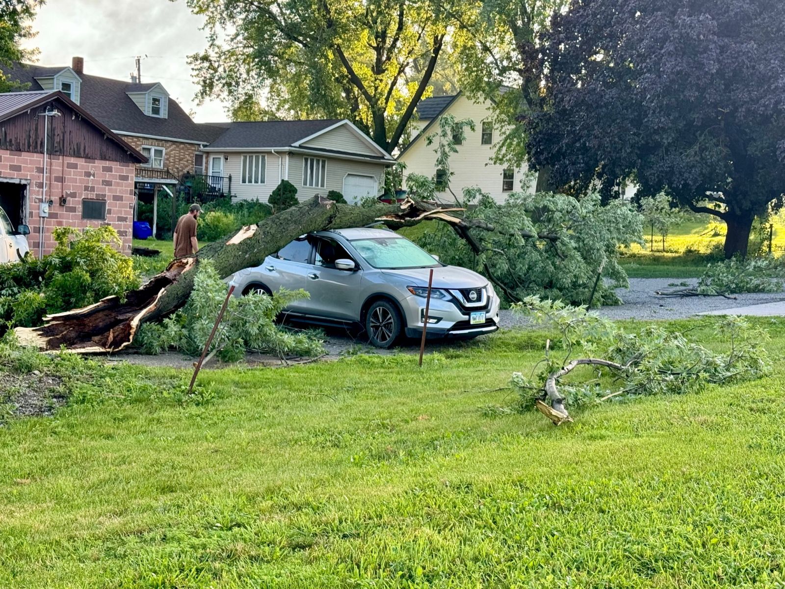
Large tree fallen on a vehicle two miles south of Frytown, IA. Courtesy of Dale B. |
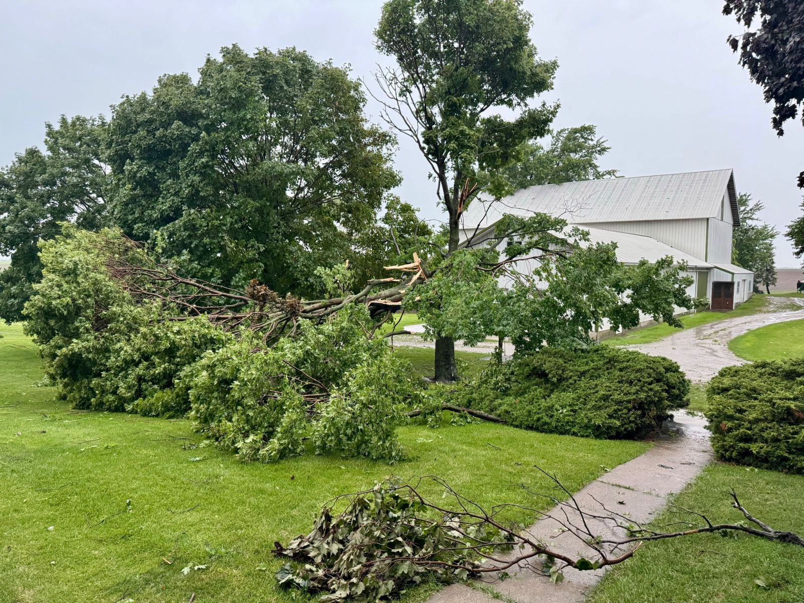
Several tree branches down in southwest Johnson County, IA. Courtesy of Dale B. |
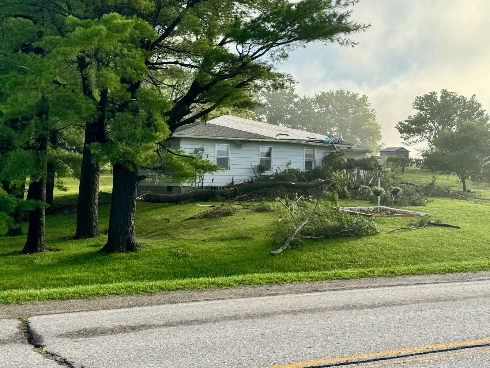
Large tree branch down, causing damage to a house two miles south of Frytown, IA. Courtesy of Dale B. |
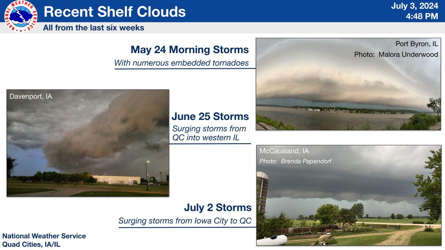
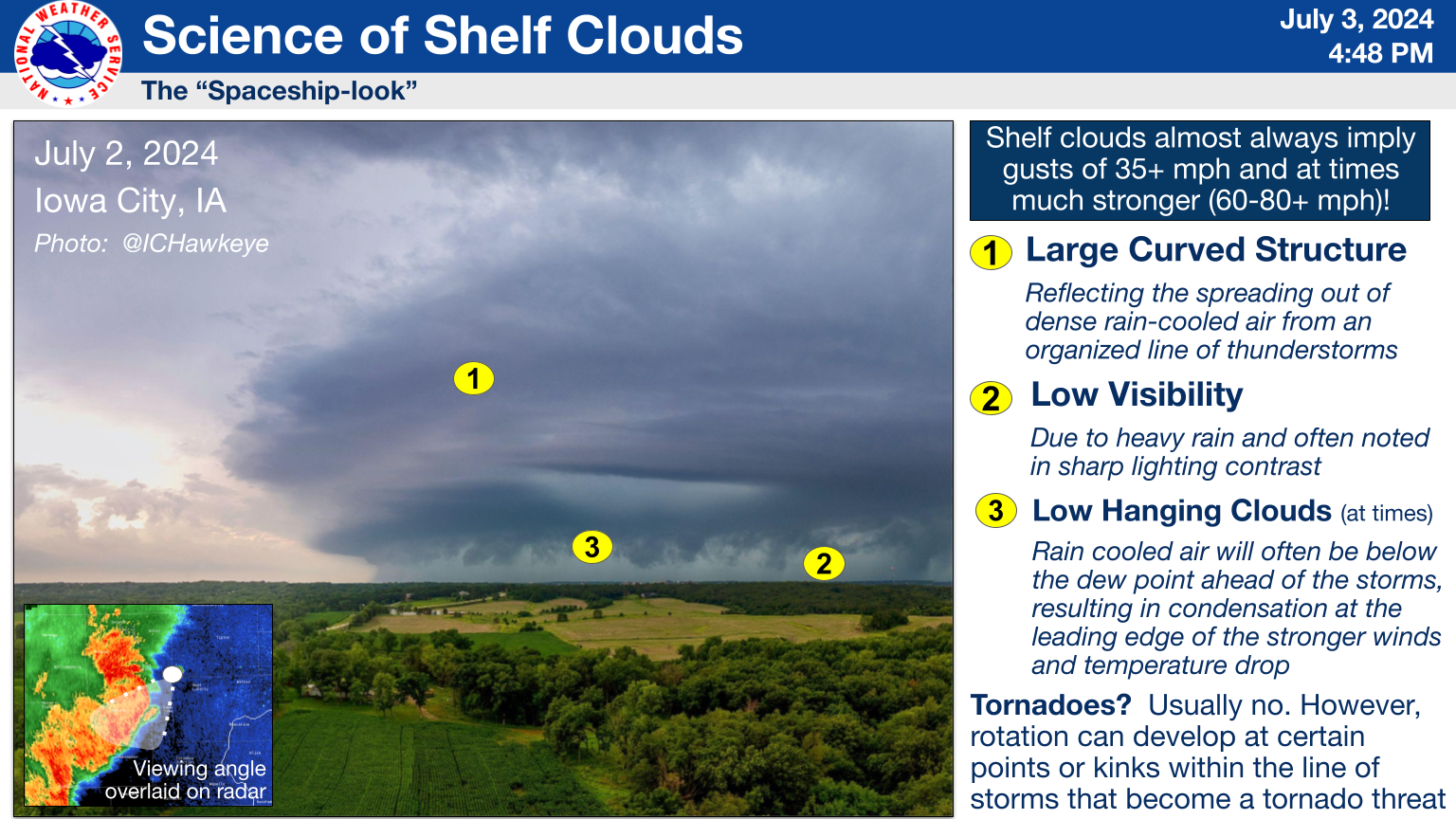
More on Shelf Clouds!
 |
 |
Storm Reports
| Nationwide Summary of Storm Reports (SPC) |
 |
| Interactive Map of Storm Reports (SPC) |
Preliminary Local Storm Report...Summary
National Weather Service Quad Cities IA IL
922 PM CDT Wed Jul 3 2024

..TIME...   ...EVENT...      ...CITY LOCATION...     ...LAT.LON...
..DATE...   ....MAG....      ..COUNTY LOCATION..ST.. ...SOURCE....
            ..REMARKS..

0504 PM     Tstm Wnd Dmg     2 WNW Keswick           41.47N 92.27W
07/02/2024                   Keokuk             IA   Trained Spotter

            Corrects time of previous report. Large oak
            tree snapped near the base, was about 30
            inches in diameter. Time was estimated by
            radar.

0510 PM     Tstm Wnd Gst     1 W Millersburg         41.57N 92.18W
07/02/2024  E70 MPH          Iowa               IA   Trained Spotter

            estimated 70 mph gusts and getting stronger.
            relayed by emergency management. time
            estimated by radar.

0518 PM     Tstm Wnd Dmg     2 SSW North English     41.49N 92.09W
07/02/2024                   Keokuk             IA   Emergency Mngr

            Keokuk County EM relayed a photo of damage
            to a house and also noted a large tree down
            on the same property.

0519 PM     Tstm Wnd Dmg     North English           41.51N 92.08W
07/02/2024                   Iowa               IA   Public

            Corrects previous tstm wnd dmg report from
            North English for time and date. Several
            reports of smaller tree limbs down in N.
            English.

0520 PM     Tstm Wnd Dmg     North English           41.52N 92.06W
07/02/2024                   Iowa               IA   CO-OP Observer

            There was one tree in N. English that was
            snapped off 12 to 15 feet up then fell on a
            house and garage and damaged them. Another
            tree was broken off and fell on a deck and
            pool. Both trees were about 12 to 18 inches
            in diameter.

0543 PM     Tstm Wnd Dmg     1 W Kalona              41.49N 91.72W
07/02/2024                   Washington         IA   Trained Spotter

            Trailer blown over on Highway 22 near
            Kalona. Time estimated by radar.

0549 PM     Tstm Wnd Gst     1 WNW Amish             41.54N 91.80W
07/02/2024  E60 MPH          Johnson            IA   Trained Spotter


0550 PM     Tstm Wnd Dmg     2 SW Williamstown       41.54N 91.75W
07/02/2024                   Johnson            IA   Trained Spotter

            Update to previous 81 mph wind gust report.
            Several large tree branches downed by the
            winds, with some trees snapped in half. One
            tree fell on their neighbors house, damaging
            the deck.

0551 PM     Tstm Wnd Gst     2 SSW Williamstown      41.54N 91.74W
07/02/2024  M81 MPH          Johnson            IA   Trained Spotter

            Measured on Davis weather station.

0600 PM     Tstm Wnd Dmg     4 WSW Iowa City Municip 41.62N 91.62W
07/02/2024                   Johnson            IA   NWS Storm Survey

            Updated report. An NWS Storm Survey team was
            unable to confirm a tornado at this
            location. There was isolated tree limb
            damage at the location, but no observed path
            of damage. Video also did not support a
            tornado.

0605 PM     Tstm Wnd Gst     Riverside               41.48N 91.57W
07/02/2024  M81 MPH          Washington         IA   Trained Spotter

            relayed by a spotter. time estimated.

0608 PM     Tstm Wnd Dmg     3 SW Oasis              41.67N 91.43W
07/02/2024                   Johnson            IA   Public

            2 fruit trees blown over and another large
            tree split. Time of the event estimated
            using radar.

0610 PM     Tstm Wnd Gst     Moline Quad-City Airpor 41.45N 90.50W
07/02/2024  M53 MPH          Rock Island        IL   ASOS


0610 PM     Tstm Wnd Dmg     Washington              41.30N 91.69W
07/02/2024                   Washington         IA   Public

            Neighbors fence blown over as well as a
            weighted basketball hoop. Time estimated
            using radar.

0610 PM     Flash Flood      2 W Thornburg           41.45N 92.37W
07/02/2024                   Keokuk             IA   Law Enforcement

            Water flowing over a gravel road between
            What Cheer and Gibson. Time estimated.

0612 PM     Flash Flood      1 SE Coralville         41.68N 91.58W
07/02/2024                   Johnson            IA   Public

            Report from mPING: Street/road flooding;
            Street/road closed; Vehicles stranded.

0615 PM     Tstm Wnd Gst     1 SW Washington Airport 41.28N 91.67W
07/02/2024  M58 MPH          Washington         IA   AWOS

            Measured wind gust from Washington Municipal
            Airport.

0620 PM     Flash Flood      1 N University Heights  41.67N 91.55W
07/02/2024                   Johnson            IA   Trained Spotter

            Around 8-10 inches of water completely
            covering the roadway between West Park Road
            and Rocky Shore Drive.

0622 PM     Tstm Wnd Dmg     4 SE Atalissa           41.51N 91.14W
07/02/2024                   Muscatine          IA   Public

            Report from mPING: 3-inch tree limbs
            broken;.

0625 PM     Tstm Wnd Gst     Ainsworth               41.29N 91.55W
07/02/2024  M60 MPH          Washington         IA   Amateur Radio


0630 PM     Rain             1 E Muscatine           41.41N 91.06W
07/02/2024  M1.55 Inch       Muscatine          IA   Public


0643 PM     Tstm Wnd Dmg     1 E Muscatine Municipal 41.36N 91.13W
07/02/2024                   Muscatine          IA   Public

            Small flag pole bent over and medium tree
            branch down.

0700 PM     Rain             2 N Central City        42.23N 91.52W
07/02/2024  M1.86 Inch       Linn               IA   Public

            Rainfall since midnight.

0705 PM     Tstm Wnd Dmg     1 SE Sherrard           41.31N 90.49W
07/02/2024                   Mercer             IL   Public

            Report from mPING: 3-inch tree limbs broken;
            Time of the report was estimated using
            radar.

0706 PM     Tstm Wnd Dmg     Bettendorf              41.53N 90.52W
07/02/2024                   Scott              IA   Public

            2 to 4 inch tree limb down in Meier
            Park-Park Staff.

0708 PM     Tstm Wnd Dmg     Milan                   41.44N 90.56W
07/02/2024                   Rock Island        IL   Public

            4 inch tree limb down. Time estimated using
            radar.

0710 PM     Rain             2 N Bankston            42.54N 90.95W
07/02/2024  M1.50 Inch       Dubuque            IA   Trained Spotter

            so far.

0722 PM     Tstm Wnd Dmg     Clinton                 41.84N 90.20W
07/02/2024                   Clinton            IA   Emergency Mngr

            Limbs down in town. Time estimated.

0740 PM     Tstm Wnd Dmg     2 SW Woodbine           42.32N 90.17W
07/02/2024                   Jo Daviess         IL   Public


0749 PM     Rain             Belle Plaine            41.90N 92.28W
07/02/2024  M1.50 Inch       Benton             IA   Trained Spotter

            so far the total for the day.

0755 PM     Flash Flood      Iowa City               41.66N 91.53W
07/02/2024                   Johnson            IA   Public

            Delayed report. Photo from social media of
            roadway inundated with water as well as
            flood waters up against a few homes.
|
Rain Reports
 |
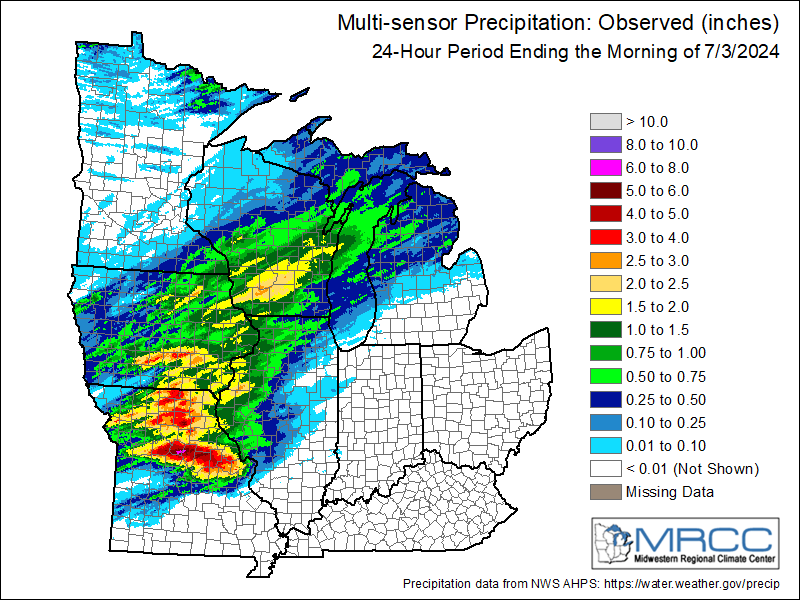 |
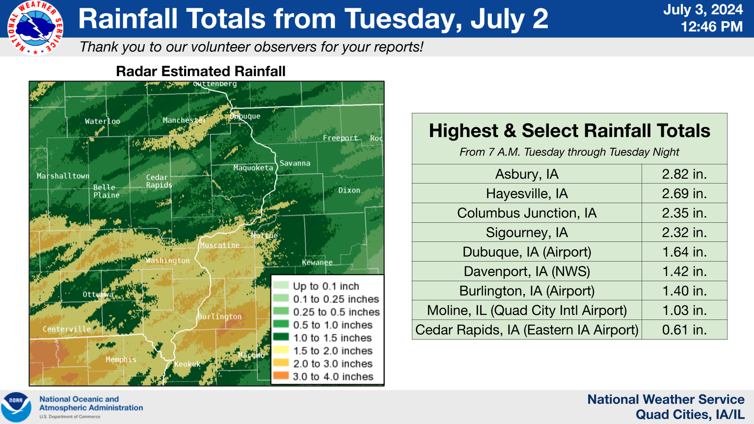
24 hour precipitation reports (in Inches), for eastern Iowa, northwest and west central Illinois, and northeast Missouri. Reported between Midnight and 9 AM, Wednesday July 03, 2024. ....IOWA.... Pella 4 N 3.28 Pella AWOS 1.5 WSW 3.00 Asbury 0.6 WNW 2.82 Hayesville 0.2 SW 2.69 Guttenberg Dam 10 2.61 Centerville 0.3 NE 2.60 Columbus Jct 2 SSW 2.35 Sigourney 2.32 Asbury 0.4 SW 2.10 North English 2.09 Asbury 0.6 S 2.08 Elkader 6SSW 1.97 Central City 6.7 W 1.96 Dubuque LD11 1.90 Strawberry Point 1.88 Wellman 4.0 E 1.85 Monticello 1 E 1.85 Danville 2.9 W 1.81 Keokuk LD19 1.81 Hopkinton 5.4 WSW 1.80 Dubuque #3 7 SW 1.78 Keokuk 3.4 NW 1.76 Morning Sun 1.7 E 1.74 Bettendorf 1.2 WNW 1.74 Manchester 1.73 Donnellson 1.72 Fairfield 5.7 NNE 1.69 Mount Auburn 2.2 NNW 1.68 Oxford Junction 2.9 ENE 1.67 Rickardsville 0.2 W 1.66 Dubuque Arpt 1.64 Yarmouth 1.9 SW 1.63 Salem 1S 1.62 Fort Madison 7.7 N 1.60 Lowden 1.58 West Point 7.5 NW 1.57 Wapello 0.2 S 1.55 Keosauqua 1.55 Coralville 1.4 S 1.54 Marengo 2.6 SSW 1.54 Coralville 1.3 SE 1.53 Burlington 0.8 SSE 1.49 Wapello 5.4 SE 1.49 New London 1.5 SW 1.48 Ainsworth 7.4 N 1.46 Dundee 1.4 NNE 1.46 Washington 1.45 Camanche 1.2 W 1.44 Bellevue LD12 1.44 Salem 3.1 ESE 1.43 Fairfield 0.7 SE 1.43 Davenport 0.9 WNW 1.43 Calamus 2.0 NE 1.43 Farmington 3.5 W 1.42 Robins 0.8 SE 1.42 Farmington 2.4 W 1.41 Fort Madison 4.5 NNW 1.40 Farmington 0.3 NW 1.40 Iowa City 2.3 E 1.40 Burlington Arpt 1.40 Farmington 0.4 NNW 1.39 Davenport 4.3 NE 1.39 Oskaloosa 1.4 NNW 1.38 Tipton 0.3 ESE 1.37 Davenport Arpt 1.37 Hillsboro 5.8 SE 1.36 Bellevue 12.2 NW 1.36 Muscatine 1.4 N 1.35 Dubuque 1.0 SE 1.35 Iowa City Arpt 1.35 Montrose 4.5 NNW 1.32 Charlotte 1.9 WNW 1.27 Marengo 3.6 N 1.27 Fort Madison 0.9 NE 1.26 Burlington 6.5 SSW 1.26 Clinton 1.7 NNW 1.25 De Witt 1.25 Dyersville 1.7 ESE 1.24 Washington 5.8 SW 1.23 Eldridge 0.6 S 1.23 Eldridge 0.7 SSW 1.21 West Branch 2.0 NNW 1.21 Le Claire 2.0 WSW 1.20 Independence 0.9 WNW 1.20 Tipton 0.7 N 1.18 Vinton 3.6 SE 1.17 Ottumwa ASOS 5.8 NNW 1.17 Tiffin 1.2 NE 1.15 Tipton 6.9 SSW 1.13 Independence 0.6 ESE 1.12 Iowa City 1.10 Solon 0.3 ESE 1.08 Grinnell AWOS 2.4 SSW 1.08 Cedar Rapids 4.1 NW 1.07 Park View 0.2 WSW 1.06 Holy Cross 1.8 E 1.06 Rathbun Reservoir 1.6 N 1.06 Muscatine 2N 1.06 Parnell 0.1 SSW 1.05 Hiawatha 0.9 SW 1.05 Shellsburg 2.9 S 1.05 Muscatine 3.0 NE 1.04 Solon 0.4 WNW 1.02 Toledo 2.8 N 1.01 Oskaloosa AWOS 9.2 ESE 0.99 Marion 1.7 NNW 0.98 Center Point 0.5 N 0.97 Vinton 0.97 North Liberty 0.7 SSW 0.95 Williamsburg 0.95 Oelwein 1E 0.93 West Branch 2.3 SSW 0.90 Belle Plaine 0.87 Marion 0.4 NNW 0.84 Fairfax 4.0 NW 0.84 Anamosa 3 SSW 0.80 Grinnell 2.3 SW 0.78 Cedar Rapids 2.7 NE 0.77 Marengo 0.77 Hampton 1 N 0.75 Mason City 0.9 NNE 0.71 Ely 0.5 SE 0.70 Anamosa 5.6 E 0.69 Ely 2.0 N 0.66 Anamosa 0.6 ESE 0.62 Center Junction 2.6 W 0.62 Cedar Rapids Arpt 0.61 Marion 0.9 NE 0.59 Oelwein AWOS 0.59 Marshalltown 1.3 NW 0.51 Waterloo ASOS 5.2 NW 0.48 Fayette 1 NW 0.45 Marshalltown ASOS 4.2 N 0.45 Mason City ASOS 6.3 W 0.40 Boone 1.3 SSW 0.28 NWS Johnston* 4.6 NNW 0.14 ....ILLINOIS.... La Harpe 2.60 Macomb 3.8 NW 2.30 Dallas City 3.0 SSE 2.03 Stronghurst 0.4 SSW 1.81 East Dubuque 1.7 SE 1.80 Illinois City 6.7 SW 1.78 Prairie City 2S 1.64 New Boston LD17 1.60 Gladstone LD18 1.56 Aledo 1.47 Ill. City LD16 3 WNW 1.43 Augusta 1.39 Taylor Ridge 1.1 E 1.35 Macomb 1.35 Bentley 1.35 Galesburg 1.30 Quincy Arpt 1.29 Colchester 3.5 NE 1.28 Warsaw 5.8 SE 1.21 Viola 0.4 E 1.14 Taylor Ridge 1.1 N 1.14 New Windsor 2.0 N 1.12 Elizabeth 1.12 Alpha 2.3 N 1.10 Fulton LD13 1.10 Stockton 5.9 WNW 1.05 Quad City Arpt 1.03 Woodhull 0.3 ESE 1.00 Moline 0.7 NNE 0.97 Shannon 2.7 E 0.97 Geneseo 2.0 NW 0.95 Stockton 4.6 NW 0.94 Galva 0.9 SE 0.93 Colona 0.5 ESE 0.88 Kewanee 1 E 0.85 Winslow 4.3 ESE 0.83 Stockton 4.5 N 0.83 Galva 0.4 NW 0.80 Galva 2.7 NE 0.80 Sterling 5.9 NNE 0.78 Lanark 4.2 NNW 0.78 Atkinson 2.6 NNE 0.75 Mount Carroll 0.75 Stockton 3.4 NNE 0.73 Stockton 3 NNE 0.73 Lanark 5.3 N 0.71 Lena 0.3 SSE 0.64 Rochelle Arpt 0.64 Freeport 0.52 Steward 0.50 Freeport 4.3 W 0.48 Jacksonville Arpt 0.46 Rockford Arpt 0.45 La Moille 0.2 NNE 0.42 Peoria Arpt 0.38 Davis 0.5 N 0.35 Jacksonville 2E 0.33 Paw Paw 1 E 0.26 McNabb 1.4 NW 0.19 Lincoln NWS 0.13 Ottawa 4 SW 0.10 Romeoville 0.05 Decatur Airport 0.04 Joliet Arpt 0.03 Bloomington Airport 0.02 Windsor 0.00 Tuscola 0.00 St Anne 0.00 Ogden 0.00 ....MISSOURI.... Kirksville Arpt 3.71 Columbia Arpt 2.97 Chillicothe Arpt 2.32 Kahoka 5.2 ESE 2.10 Kahoka 0.6 S 1.78 Memphis 0.1 S 1.75 Memphis 1.62 ....WISCONSIN.... Madison Arpt 2.07 Viroqua 1.82 Monroe 1 W 1.32 Prairie du Chien AWOS 0.93 La Crosse WFO 0.89 Brodhead 1 SW 0.87 Darlington 0.75 Sullivan-NWS 2 SE 0.55 Watertown-Arpt 0.53 Whitewater 0.49 Beloit-College 0.43 Delavan-1 W-WWTP 1 W 0.37 ....MINNESOTA.... Theilman 1SSW 0.49 |
...PRECIPITATION REPORTS... Location Amount Time/Date Lat/Lon 1 WNW Washington 2.85 in 0340 AM 07/03 41.31N/91.72W Asbury 0.6 WNW 2.82 in 1200 AM 07/03 42.52N/90.77W Aurora 2.55 in 0330 AM 07/03 42.62N/91.73W CENTRAL CITY 2.24 in 1220 AM 07/03 42.20N/91.53W Kahoka 2.21 in 0336 AM 07/03 40.38N/91.63W 2 NNW Manchester Airport 2.16 in 0340 AM 07/03 42.54N/91.52W Independence 2.10 in 0330 AM 07/03 42.48N/91.89W Dubuque 2.03 in 0337 AM 07/03 42.46N/90.77W Dubuque 2.02 in 0335 AM 07/03 42.51N/90.72W 1.1 SE Manchester (R2) (R2 1.85 in 0300 AM 07/03 42.47N/91.45W Dubuque Arpt 1.76 in 0305 AM 07/03 42.40N/90.70W Independence 1.76 in 0330 AM 07/03 42.47N/91.88W Winthrop 1.71 in 0330 AM 07/03 42.47N/91.73W New London 1.68 in 0330 AM 07/03 40.97N/91.34W Riverside 1.66 in 0336 AM 07/03 41.53N/91.62W Middleburg 1.64 in 0330 AM 07/03 42.41N/90.35W Waupeton 1.64 in 0245 AM 07/03 42.67N/90.88W Independence Arpt 1.59 in 0335 AM 07/03 42.45N/91.95W Quasqueton 1.58 in 0330 AM 07/03 42.39N/91.76W Dubuque 1.57 in 0338 AM 07/03 42.53N/90.68W WHEATLAND 1.56 in 0340 AM 07/03 41.79N/90.81W 2.5 SW Newport 1.56 in 0300 AM 07/03 41.70N/91.49W SHELLSBURG 1.55 in 0335 AM 07/03 42.09N/91.87W Dubuque 1.54 in 0336 AM 07/03 42.47N/90.65W 1.1 SE Manchester (R2) (R2 1.46 in 0315 AM 07/03 42.47N/91.45W IOWA CITY 1.45 in 0338 AM 07/03 41.68N/91.52W Muscatine 1.45 in 0330 AM 07/03 41.42N/91.05W Macomb Arpt 1.43 in 0335 AM 07/03 40.52N/90.65W Washington 1.42 in 0345 AM 07/03 41.29N/91.69W 1 NE Watkins 1.41 in 0340 AM 07/03 41.90N/91.96W Stronghurst 1.41 in 0337 AM 07/03 40.74N/90.91W 2.1 NE New Boston (R2) (R2 1.38 in 0200 AM 07/03 41.19N/90.97W 3.1 W Oakland Mills 1.38 in 0330 AM 07/03 40.93N/91.67W Fairfield Arpt 1.37 in 0335 AM 07/03 41.03N/91.97W 2.1 NE New Boston (R2) (R2 1.36 in 0330 AM 07/03 41.19N/90.97W Iowa City Arpt 1.35 in 0304 AM 07/03 41.63N/91.55W Burlington Arpt 1.34 in 0253 AM 07/03 40.77N/91.13W Urbana 1.33 in 0330 AM 07/03 42.22N/91.88W Iowa City 1.31 in 0340 AM 07/03 41.65N/91.48W Mississippi River 1.30 in 0300 AM 07/03 40.82N/91.10W Davenport 1.28 in 0330 AM 07/03 41.59N/90.61W Dubuque 1.27 in 0325 AM 07/03 42.51N/90.69W No.2-River 1.26 in 0330 AM 07/03 42.50N/90.65W 1.0 NW Niota 1.26 in 0330 AM 07/03 40.63N/91.30W Monmouth 1.26 in 0335 AM 07/03 40.93N/90.63W Iowa City 1.26 in 0340 AM 07/03 41.64N/91.51W 2 ENE Dysart 1.23 in 0340 AM 07/03 42.19N/92.26W MACOMB 1.14 in 0336 AM 07/03 40.37N/90.70W Davenport Arpt 1.12 in 0252 AM 07/03 41.62N/90.58W Clear Crk At Coralville 1.10 in 0300 AM 07/03 41.68N/91.60W Eldridge 1.05 in 0338 AM 07/03 41.64N/90.59W 3 S Mount Joy 1.00 in 0340 AM 07/03 41.57N/90.55W Observations are collected from a variety of sources with varying equipment and exposures. We thank all volunteer weather observers for their dedication. Not all data listed are considered official. |
Environment
Synoptic Summary
 |
 |
 |
 |
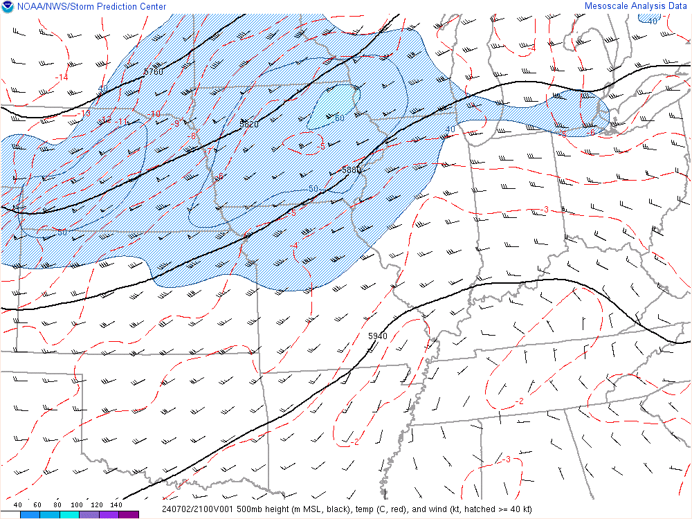
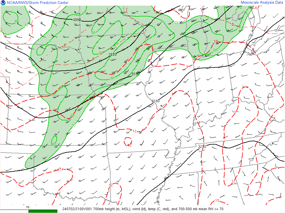
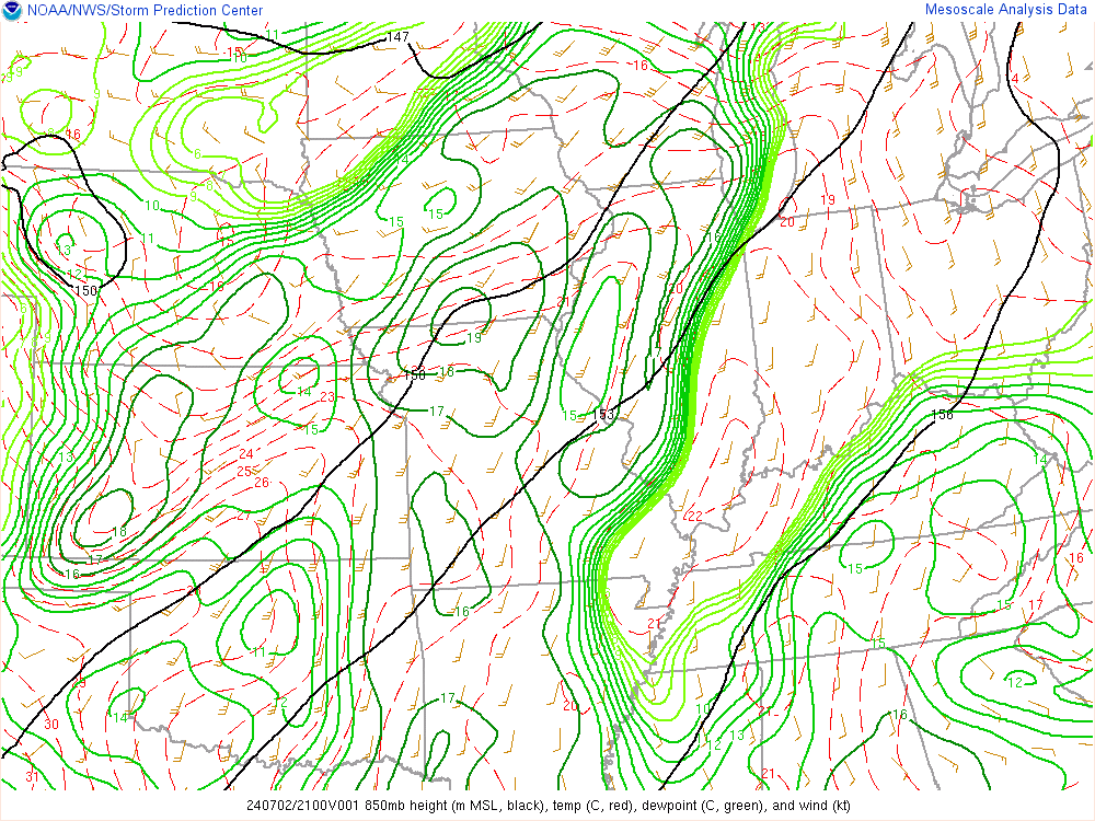
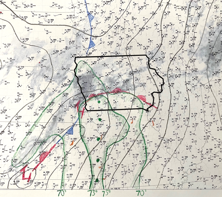
| 21z - 500 mb Chart | 21z - 700 mb Chart | 21z - 850 mb Chart | 21z - Surface Chart |
Near-Storm Environment Summary
 |
|
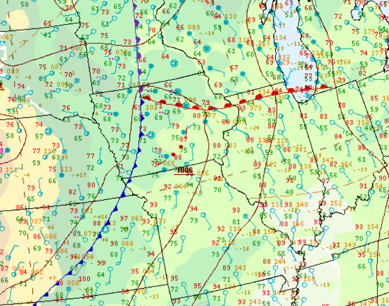
12 P.M. Surface Weather Map, indicating a warm front ushering into southern Iowa mid 70s dew points. |
 |
 |
 |
 |
|
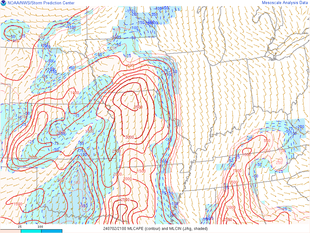
21z - MLCAPE Instability Present |
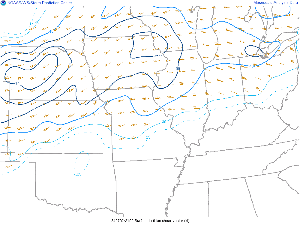
21z - 0-6 km Shear Shear For Organized Storms |
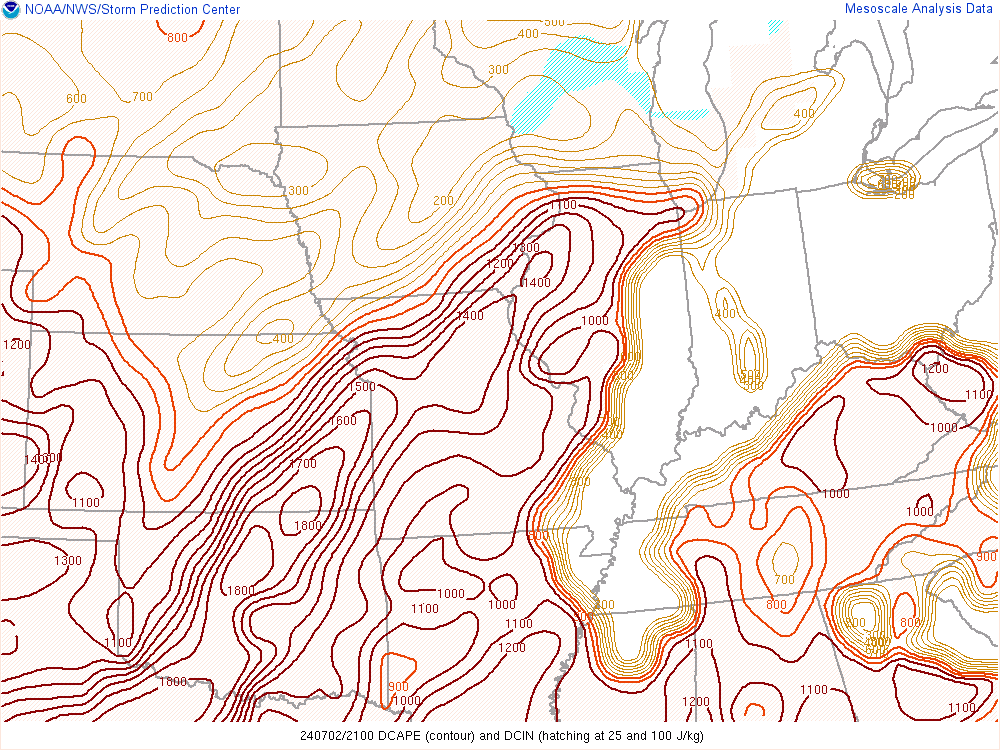
21z - DCAPE Favorable For Downdrafts |
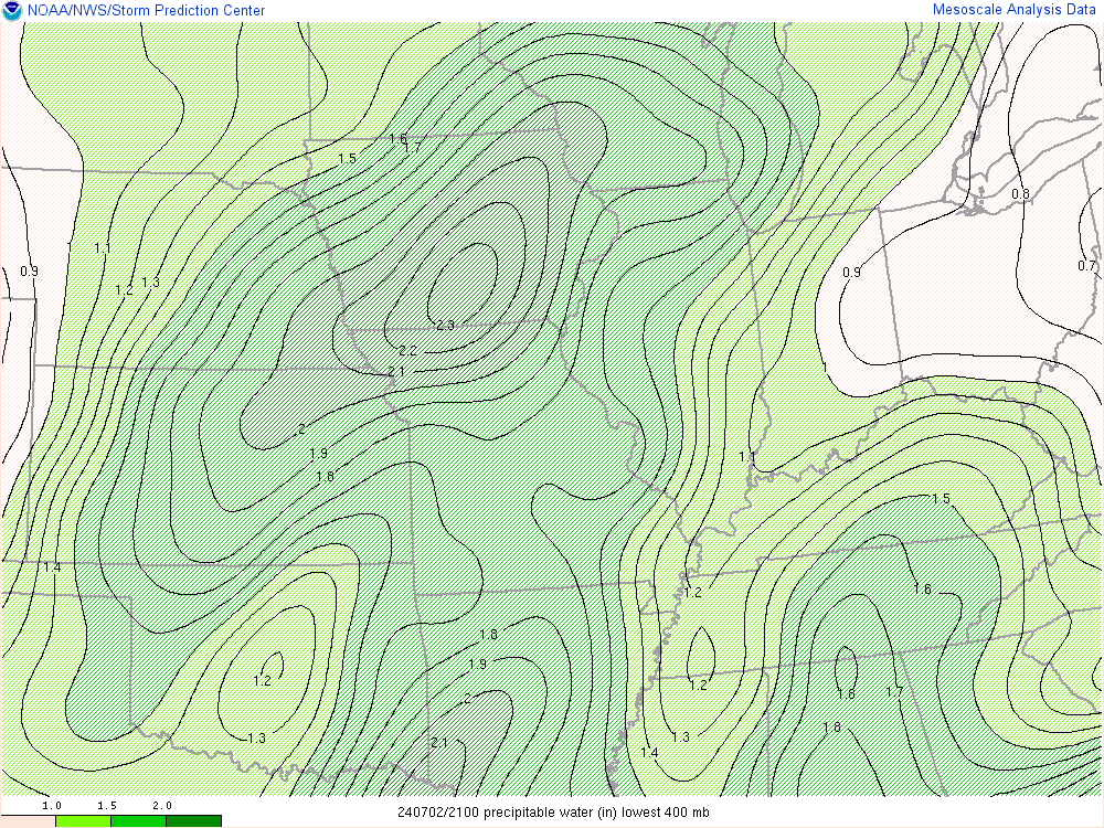
21z - PWATS Measure of Water in Air |
 |
.gif) |
|
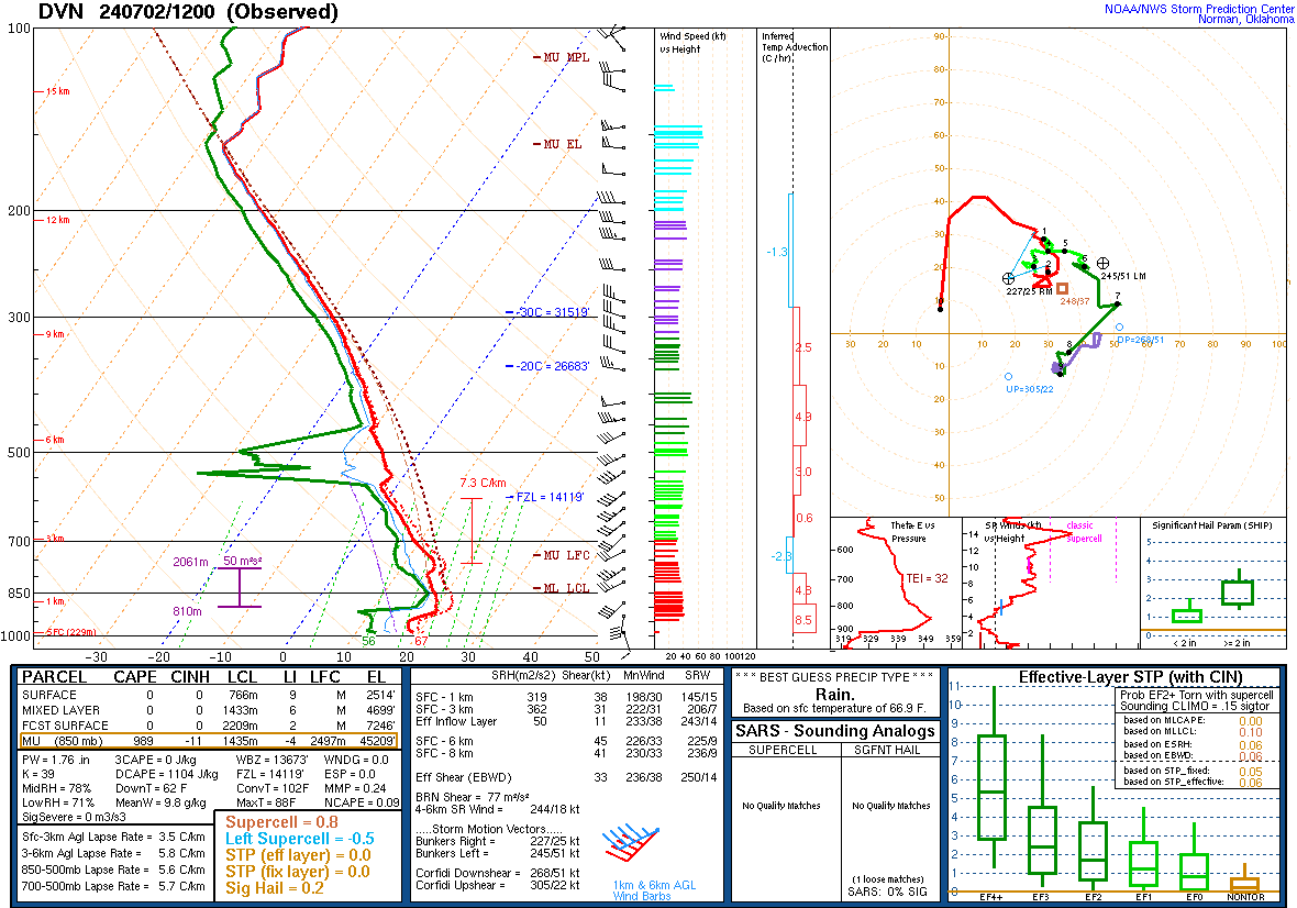
7/2 - 12z DVN Sounding |
7/3 - 00z DVN Sounding |
Severe/Tornado Watches & MCDs
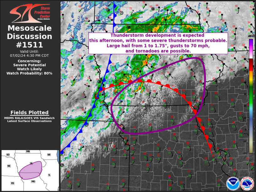 |
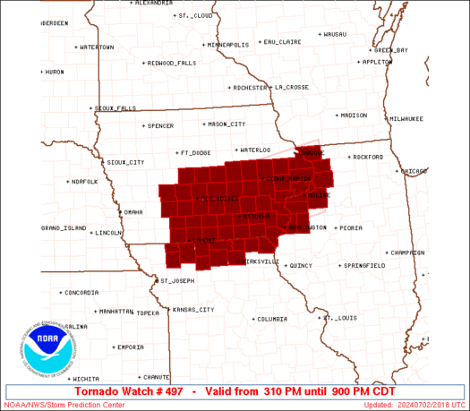 |
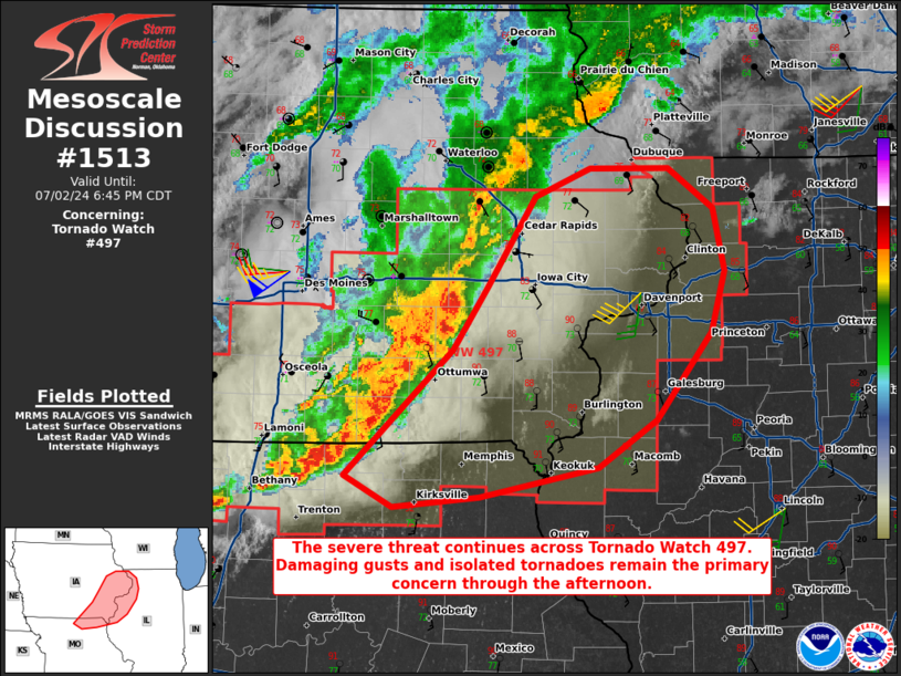 |
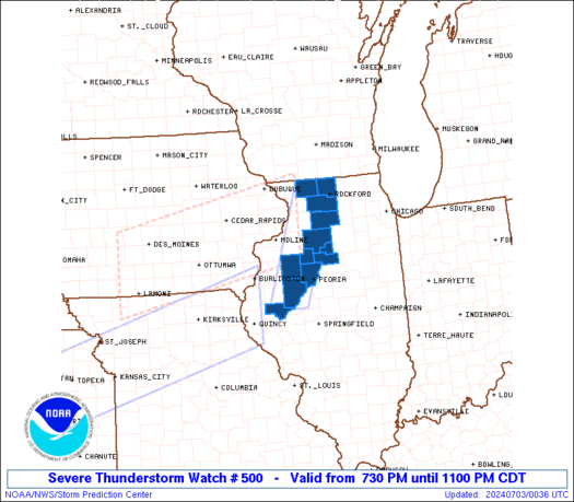 |
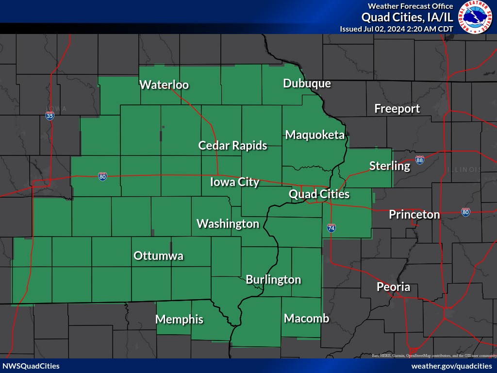
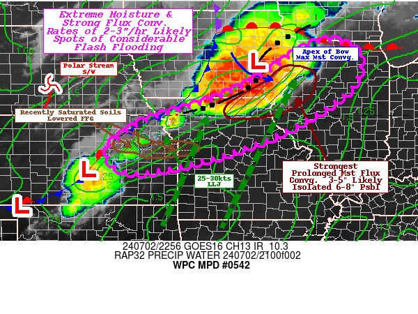
Flood Watch & MPD
 |
 |
|
Flood Watch For Flash Flooding |
NWS Quad Cities Weather Stories
 |
 |
 |
 |
|
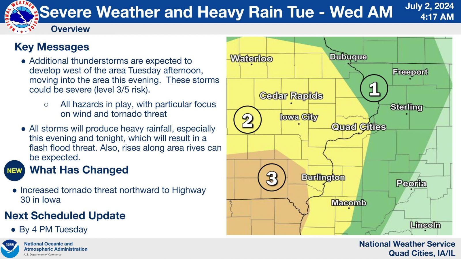
Weather Story: 4:17 A.M. |
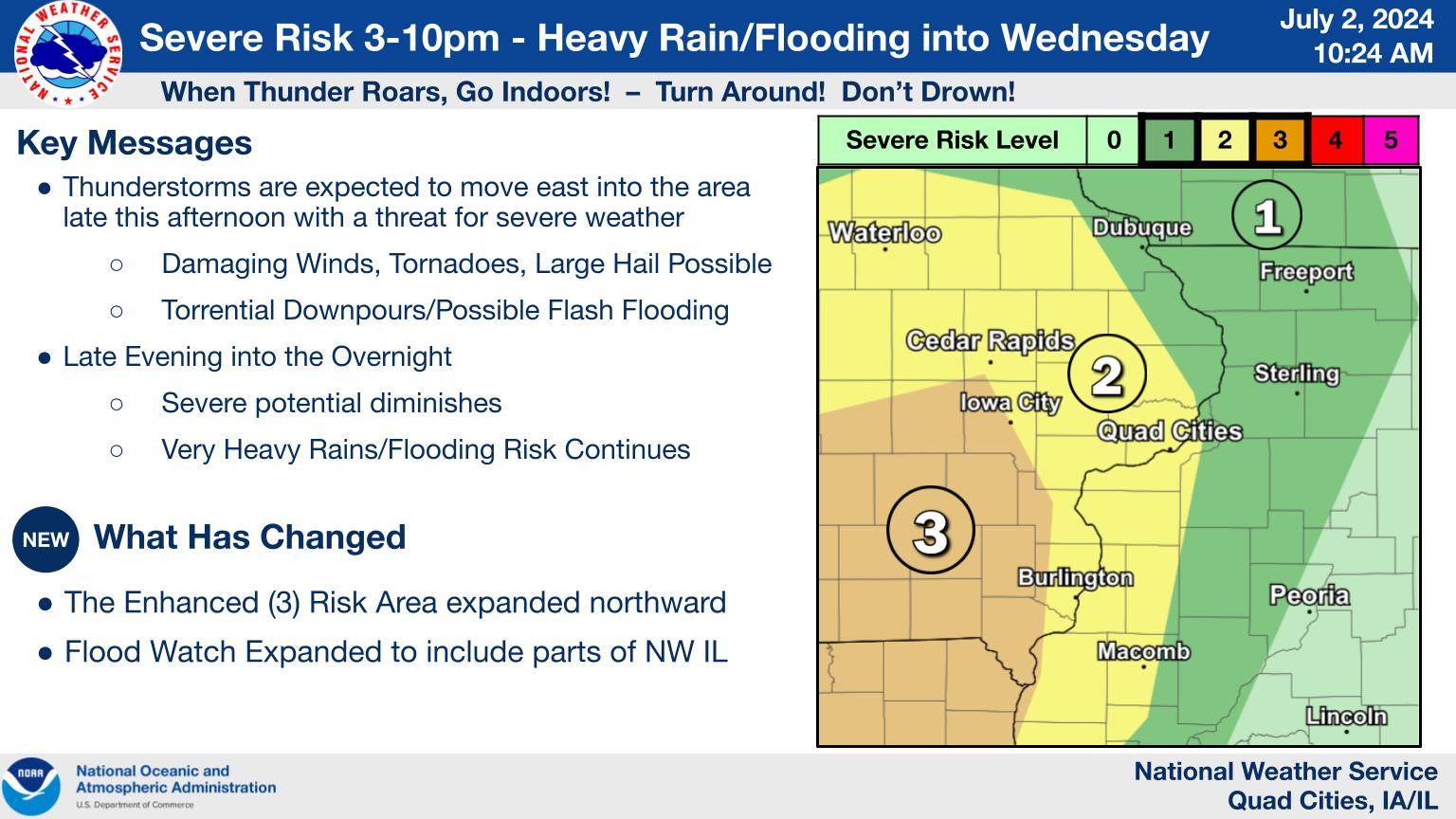
Weather Story: 10:24 A.M. |
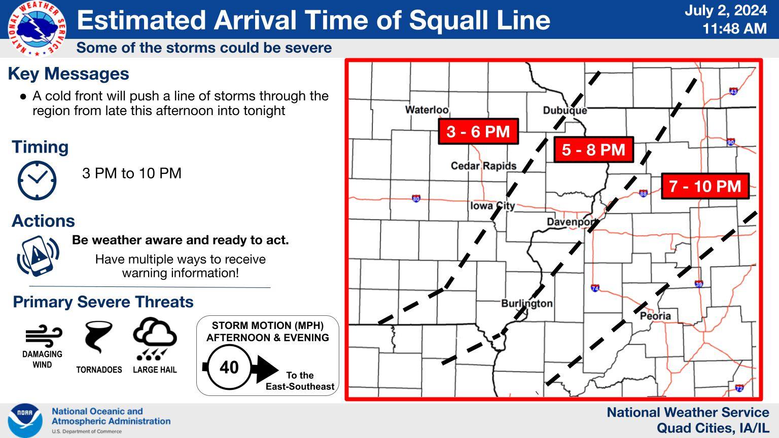
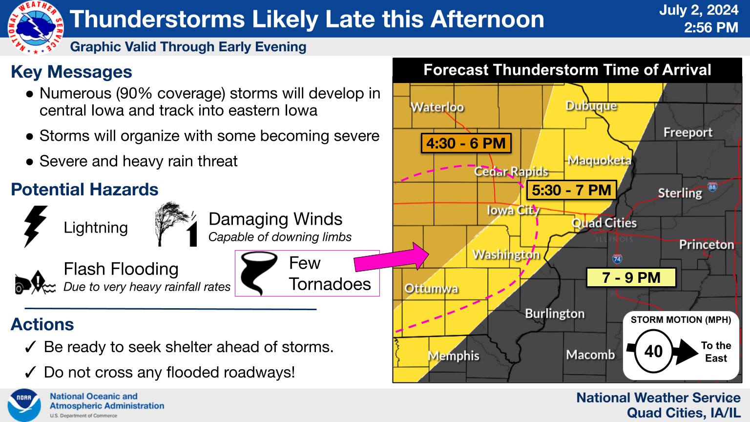
Weather Story: 11:48 A.M. | Weather Story: 2:56 P.M. |
 |
Media use of NWS Web News Stories is encouraged! Please acknowledge the NWS as the source of any news information accessed from this site. |
|

