Overview:
|
|
Radar Loop Courtesy of the IEM |
Storm Reports
INTERACTIVE MAP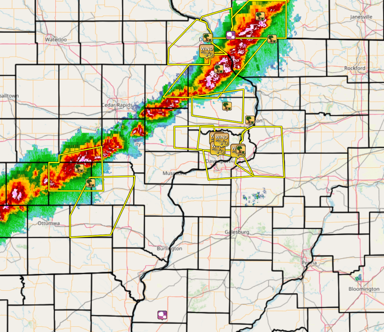 |
PRELIMINARY LOCAL STORM REPORT NATIONAL WEATHER SERVICE QUAD CITIES IA IL TUESDAY JUN 21 2022 |
..TIME... ...EVENT... ...CITY LOCATION... ...LAT.LON... ..DATE... ....MAG.... ..COUNTY LOCATION..ST.. ...SOURCE.... ..REMARKS.. 0630 PM TSTM WND GST DUBUQUE REGIONAL ARPT 42.40N 90.70W 06/21/2022 M54 MPH DUBUQUE IA ASOS ASOS STATION KDBQ DUBUQUE ARPT. 0636 PM TSTM WND DMG DUBUQUE 42.51N 90.69W 06/21/2022 DUBUQUE IA LAW ENFORCEMENT TREE BLOWN INTO POWERLINES AND DOWNED SOME OF THEM. 0651 PM TSTM WND DMG 2 NE COTTONVILLE 42.26N 90.57W 06/21/2022 JACKSON IA PUBLIC PUBLIC REPORT OF 61 MPH THUNDERSTORM WIND GUST AT A GRASS STRIP AIRPORT 7 MILES WEST OF BELLEVUE. REPORT RELAYED BY BROADCAST MEDIA. TIME OF THE EVENT ESTIMATED USING RADAR. 0709 PM TSTM WND DMG SOUTH ENGLISH 41.46N 92.08W 06/21/2022 KEOKUK IA CO-OP OBSERVER COOP OBSERVER FROM NORTH ENGLISH REPORTS A FEW TREES DOWN IN SOUTH ENGLISH FROM WINDS PRODUCED BY THE THUNDERSTORMS. TIME ESTIMATED BY RADAR. 0720 PM TSTM WND DMG WARREN 42.50N 89.99W 06/21/2022 JO DAVIESS IL TRAINED SPOTTER LARGE TREE BRANCH DOWN. TIME OF THE EVENT ESTIMATED USING RADAR. 0745 PM TSTM WND DMG 2 S KEOTA 41.34N 91.96W 06/21/2022 KEOKUK IA PUBLIC VIA TWITTER, REPORTED 1 TO 2 INCH TREE BRANCHES DOWN. TIME OF THE EVENT WAS ESTIMATE USING RADAR. 0759 PM TSTM WND DMG CHARLOTTE 41.96N 90.48W 06/21/2022 CLINTON IA PUBLIC BROADCAST MEDIA RELAYED A PUBLIC REPORT OF TREES DOWN IN CHARLOTTE WITH DAMAGE TO POWER POLES. TIME OF THE EVENT ESTIMATED USING RADAR. 0825 PM TSTM WND DMG CLINTON 41.85N 90.23W 06/21/2022 CLINTON IA 911 CALL CENTER TREE DOWN ON A HOUSE. 0850 PM TSTM WND GST 1 NW LONG GROVE 41.70N 90.59W 06/21/2022 E60 MPH SCOTT IA LAW ENFORCEMENT TREE DOWN ACROSS CADDA RD. 0854 PM TSTM WND GST DAVENPORT MUNICIPALITY 41.62N 90.58W 06/21/2022 M49 MPH SCOTT IA ASOS ASOS STATION KDVN DAVENPORT ARPT. 0855 PM TSTM WND GST PARK VIEW 41.69N 90.54W 06/21/2022 E60 MPH SCOTT IA NWS EMPLOYEE TREE DOWN IN PARK VIEW. 0910 PM TSTM WND GST LE CLAIRE 41.60N 90.36W 06/21/2022 E60 MPH SCOTT IA TRAINED SPOTTER TREE BRANCHES ABOUT 3 TO 4 INCHES IN DIAMETER DOWN IN NEIGHBORS YARD. 0918 PM TSTM WND DMG 1 S PORT BYRON 41.61N 90.33W 06/21/2022 ROCK ISLAND IL PUBLIC TREE BLOWN DOWN. TIME ESTIMATED FROM RADAR DATA. 1130 PM HAIL WEST POINT 40.26N 91.18W 06/21/2022 E0.25 INCH HANCOCK IL PUBLIC RELAYED BY WGEM. |
Rain Reports
 |
24 hour precipitation reports (in Inches), for eastern Iowa, northwest and west central Illinois, and northeast Missouri. Reported between Midnight and 9 AM, Wednesday June 22, 2022. ....IOWA.... Rathbun Reservoir 2 N 1.36 Park View 0.2 WSW 0.87 Centerville 0 NE 0.62 North English 0.58 Keokuk LD19 0.47 Eldridge 0.6 S 0.44 Iowa City 0.40 Oskaloosa 1 NNW 0.38 Asbury 0.4 SW 0.36 Davenport Arpt 0.36 Iowa City Arpt 0.32 Sigourney 0.30 Ottumwa ASOS 6 NNW 0.26 Wellman 4.0 E 0.20 Camanche 1.2 W 0.20 Dubuque #3 7 SW 0.20 West Liberty 0.7 NNW 0.19 Dubuque LD11 0.19 De Witt 0.16 Oskaloosa AWOS 9 ESE 0.14 Peosta 2.9 E 0.12 Fairfield 0.11 Dubuque Arpt 0.10 New London 1.5 SW 0.08 Maquoketa 0.08 Keosauqua 0.07 Ainsworth 7.4 N 0.05 North Liberty 0.7 SSW 0.05 Fort Madison 0.9 NE 0.04 Burlington 6.5 SSW 0.04 Salem 3.1 ESE 0.04 Le Claire LD14 0.04 Mt Pleasant 1 SSW 0.04 Washington 5.8 SW 0.03 Parnell 0.1 SSW 0.03 Lowden 0.03 Salem 1S 0.03 Wapello 4.7 N 0.02 Center Junction 2.6 W 0.02 Donnellson 0.02 Anamosa 3 SSW 0.02 Tipton 0.7 N 0.01 Hopkinton 5.4 WSW 0.01 ....ILLINOIS.... Warsaw 5.8 SE 0.43 Elizabeth 0.30 Fulton LD13 0.25 Hanover 0.2 NW 0.18 Atkinson 2.6 NNE 0.12 Winslow 4.3 ESE 0.11 Prophetstown 0.2 SW 0.06 Colchester 3.5 NE 0.02 Augusta 0.02 Quincy Arpt 0.02 Stronghurst 0.4 SSW 0.01 Lanark 5.3 N 0.01 ....MISSOURI.... Kirksville Arpt 0.76 Kahoka 0.6 S 0.67 Chillicothe Arpt 0.61 Memphis 0.25 ....WISCONSIN.... Darlington 0.25 Sullivan-NWS 2 SE 0.06 Monroe 1 W 0.05 Brodhead 1 SW 0.01 |
 |
Media use of NWS Web News Stories is encouraged! Please acknowledge the NWS as the source of any news information accessed from this site. |
|

