Overview
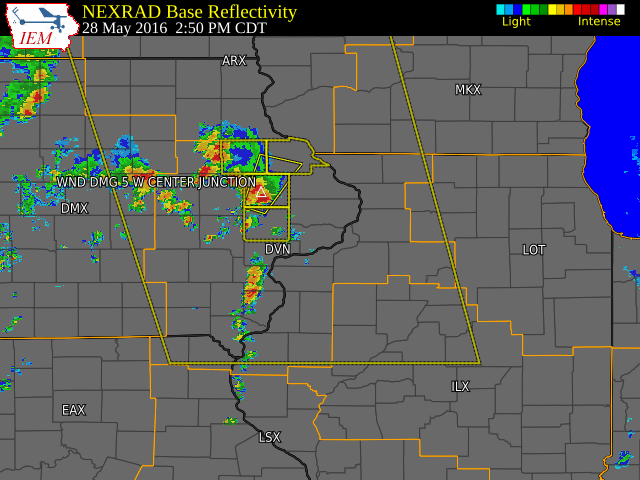
| Low pressure lifted northeast across northwest Iowa and southern Minnesota Saturday afternoon, swinging a cold front into eastern Iowa. Scattered showers and thunderstorms, some severe, developed out ahead of the front. The primary threat was damaging winds. The hardest hit areas were Center Junction, Cascade, Peosta, and Sageville; where there was tree, power line, and structural damage reported. Brief heavy rains also accompanied the storms, with some areas picking up a third to two thirds of an inch in a matter of minutes. Otherwise, skies were partly to mostly sunny and afternoon highs topped out in the upper 70s to mid 80s. |  |
 |
|
|
||
|
PRELIMINARY LOCAL STORM REPORT...SUMMARY ..TIME... ...EVENT... ...CITY LOCATION... ...LAT.LON... 0256 PM TSTM WND DMG 5 W CENTER JUNCTION 42.11N 91.19W EMERGENCY MANAGER REPORTED POWER LINES DOWN AND THE ROOF 0300 PM FUNNEL CLOUD 8 N OLIN 42.11N 91.14W ESTIMATED TIME. SPOTTER OBSERVED FUNNEL CLOUD A LITTLE
FIRE DEPARTMENT ESTIAMTED WIND GUST OF 60 MPH. REPORTED 0322 PM HAIL SW CASCADE 42.30N 91.01W 0345 PM TSTM WND DMG 1 N PEOSTA 42.46N 90.85W TWO FOOT DIAMETER TREE SNAPPED OFF. 0346 PM TSTM WND DMG SAGEVILLE 42.55N 90.70W ROOF RIPPED OFF OF SCHOOL...NOT SURE IF IT IS PARTIAL OR 0348 PM TSTM WND DMG DUBUQUE 42.50N 90.69W REPORTS OF POWERLINES DOWN AND ROOF DAMAGE ON THE 0350 PM TSTM WND DMG 3 NE PEOSTA 42.48N 90.81W WIRES DOWN ALONG OLD HIGHWAY ROAD NEAR HILLDALE LANE WEST 0400 PM TSTM WND DMG 4 NW DUBUQUE 42.55N 90.75W TREE FELL ONTO OCCUPIED VEHICLE NEAR 5200 N AND RUPP 0400 PM TSTM WND GST 2 WNW DUBUQUE 42.55N 90.75W MULTIPLE TREES DOWN IN THE AREA. ONE TREE FELL ONTO A 0430 PM HEAVY RAIN 1 E INDEPENDENCE 42.47N 91.88W RAIN TOTAL SINCE NOON. 0442 PM HAIL DAVENPORT 41.56N 90.60W HAIL FELL FROM 448 TO 442 0443 PM HAIL DAVENPORT 41.56N 90.60W LOCAL BROADCAST MEDIA REPORTS DIME SIZE HAIL FALLING IN 0548 PM HAIL 5 NNW LANARK 42.17N 89.88W FELL FOR TWO MINUTES 0557 PM HAIL GALVA 41.17N 90.04W 0615 PM HAIL 2 W ROCK FALLS 41.77N 89.73W DIME SIZE HAIL ALONG WITH 40 MPH WINDS. |
||
 |
Media use of NWS Web News Stories is encouraged! Please acknowledge the NWS as the source of any news information accessed from this site. |
 |