Dangerous, record-breaking heat will intensify across most of the central and eastern U.S this week. Heat indices will likely exceed 100 degrees. Heat is likely to continue across the eastern U.S. through the Independence Day holiday weekend. Critical fire weather conditions will continue today and likely Tuesday across portions of the Four Corners and northern High Plains. Read More >
Overview
|
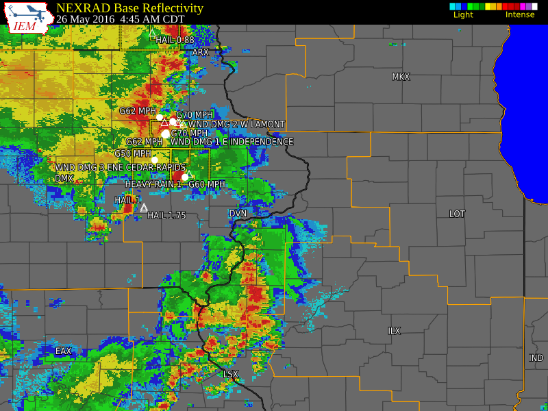
Showers and thunderstorms developed early Thursday morning, ahead of a cold front that pushed east into central Iowa. Some of these storms produced damaging winds over 70 mph across Benton, Linn, Buchanan, and Delware counties in Iowa. Golf ball sized hail also fell west of Millersburg in Iowa county just before 5 am. Torrential rains also accompanied the storms, as they quickly rolled through the area. Rain amounts between a inch and one and a half inches were common for those that saw the storms. Elsewhere, rain amounts were between a trace to a tenth of an inch. |
Storm Reports
 |
| Link to Storm Reports |
PRELIMINARY LOCAL STORM REPORT...SUMMARY
NATIONAL WEATHER SERVICE QUAD CITIES IA IL
1138 AM CDT THU MAY 26 2016

..TIME...   ...EVENT...      ...CITY LOCATION...     ...LAT.LON...
..DATE...   ....MAG....      ..COUNTY LOCATION..ST.. ...SOURCE....
            ..REMARKS..

0436 AM     TSTM WND DMG     HAZLETON                42.62N 91.91W
05/26/2016                   BUCHANAN           IA   CO-OP OBSERVER

            20 INCH DIAMETER LIMB ON WIRES JUST SOUTH OF 3RD AND
            BENTON IN HAZELTON.

0440 AM     TSTM WND DMG     1 E INDEPENDENCE        42.47N 91.88W
05/26/2016                   BUCHANAN           IA   TRAINED SPOTTER

            WIND ESTIMATED OVER 60 MPH. TREE BRANCHES AND FLAG POLE
            DOWN.

0442 AM     TSTM WND GST     VINTON                  42.16N 92.03W
05/26/2016  E50.00 MPH       BENTON             IA   EMERGENCY MNGR

0443 AM     TSTM WND GST     INDEPENDENCE            42.47N 91.89W
05/26/2016  M62.00 MPH       BUCHANAN           IA   AWOS

0445 AM     TSTM WND GST     1 WNW INDEPENDENCE      42.47N 91.91W
05/26/2016  E80.00 MPH       BUCHANAN           IA   TRAINED SPOTTER

0447 AM     TSTM WND GST     1 SSE CEDAR RAPIDS      41.95N 91.66W
05/26/2016  E60.00 MPH       LINN               IA   TRAINED SPOTTER

            WINDS GUSTING TO ABOUT 60 MPH FOR THE PAST MINUTE. STRONG
            WINDS CONTINUE.

0450 AM     TSTM WND GST     1 N INDEPENDENCE        42.49N 91.89W
05/26/2016  E70.00 MPH       BUCHANAN           IA   TRAINED SPOTTER

            POWER OUT.

0453 AM     TSTM WND DMG     3 ENE CEDAR RAPIDS      41.99N 91.61W
05/26/2016                   LINN               IA   TRAINED SPOTTER

            LARGE TREE LIMBS DOWN.

0453 AM     TSTM WND GST     1 S STANLEY             42.63N 91.81W
05/26/2016  E70.00 MPH       BUCHANAN           IA   TRAINED SPOTTER

            SUSTAINED WINDS OF 50 MPH WITH GUSTS TO 70 MPH FOR THE
            PAST 10 MINUTES.

0455 AM     TSTM WND DMG     1 S STANLEY             42.63N 91.81W
05/26/2016                   BUCHANAN           IA   CO-OP OBSERVER

            TREE BLOWN ONTO AN UNOCCUPIED HOUSE IN STANLEY. TIME
            ESTIMATED.

0455 AM     TSTM WND DMG     2 W LAMONT              42.60N 91.68W
05/26/2016                   BUCHANAN           IA   CO-OP OBSERVER

            CATTLE SHED DESTROYED AND BLOWN INTO FARM FIELD. TIME
            ESTIMATED.

0455 AM     TSTM WND DMG     AURORA                  42.62N 91.73W
05/26/2016                   BUCHANAN           IA   CO-OP OBSERVER

            LARGE TREE SNAPPED IN CITY PARK. ALSO HALF OF A LARGE
            TREE FELL ONTO A VAN AT 103 MAIN STREET.

0455 AM     HEAVY RAIN       1 SSE CEDAR RAPIDS      41.95N 91.66W
05/26/2016  M1.00 INCH       LINN               IA   TRAINED SPOTTER

            ONE INCH OF RAIN IN 15 MINUTES.

0455 AM     TSTM WND GST     INDEPENDENCE            42.47N 91.89W
05/26/2016  M70.00 MPH       BUCHANAN           IA   AWOS

0455 AM     HAIL             MILLERSBURG             41.57N 92.16W
05/26/2016  E1.75 INCH       IOWA               IA   EMERGENCY MNGR

            RELAYED BY EMERGENCY MANAGER. ALSO WINDS ESTIMATED AT 50
            MPH.

0455 AM     TSTM WND DMG     1 W AURORA              42.62N 91.75W
05/26/2016                   BUCHANAN           IA   CO-OP OBSERVER

            30 TO 40 FOOT TALL TREE BLOWN DOWN INTO A FARM FIELD NEAR
            115TH STREET AND REED AVE. TIME ESTIMATED.

0459 AM     HAIL             1 N MILLERSBURG         41.59N 92.16W
05/26/2016  E1.00 INCH       IOWA               IA   EMERGENCY MNGR

0500 AM     TSTM WND DMG     2 SSE DUNDEE            42.55N 91.53W
05/26/2016                   DELAWARE           IA   CO-OP OBSERVER

            2 FOOT DIAMETER TREE SNAPPED ABOUT 4 TO 5 FEET ABOVE THE
            GROUND AT 1435 165TH STREET ABOUT 2 MILES SOUTH SOUTHEAST
            OF DUNDEE. TIME ESTIMATED.

0515 AM     TSTM WND DMG     1 S EDGEWOOD            42.63N 91.40W
05/26/2016                   DELAWARE           IA   TRAINED SPOTTER

            3 INCH DIAMETER BRANCHES DOWN. TIME ESTIMATED.
Rain reports
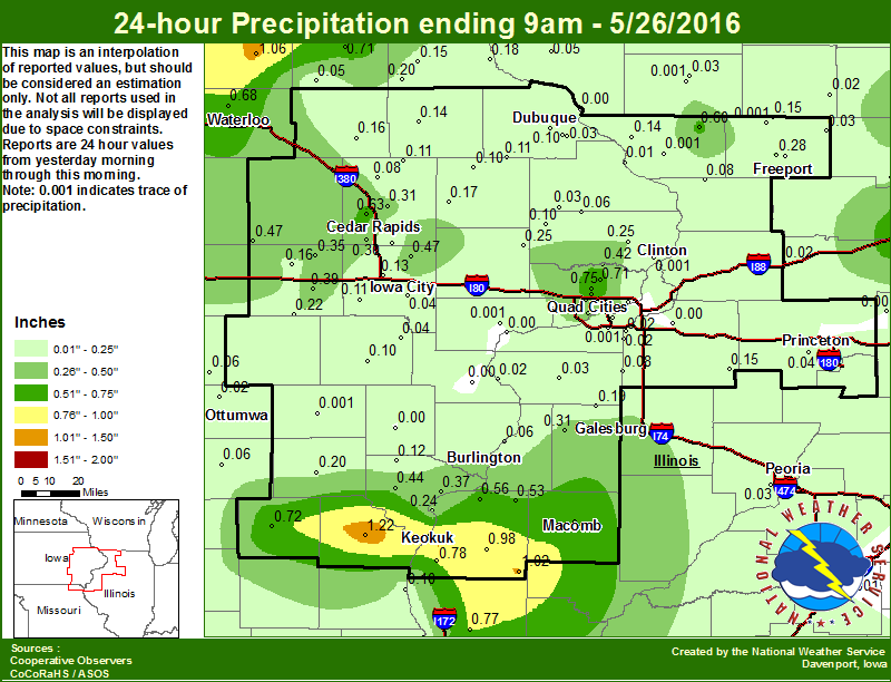 |
| Figure 1: Local Map Analysis |
24 hour precipitation reports (in Inches),
for eastern Iowa, northwest and west central Illinois,
and northeast Missouri. Reported between Midnight and 9 AM,
Thursday May 26, 2016.

....IOWA....
Mason City ASOS                  1.15
Keokuk LD19                      1.13
Tripoli                          1.06
Keokuk 0.6 NE                    1.02
Hampton                          0.85
Mason City*                      0.85
Mason City                       0.84
Cresco                           0.77
Eldridge 0.7 SSW                 0.75
Fayette                          0.71
Park View 0.2 WSW                0.71
Waterloo ASOS                    0.68
NWS Johnston*                    0.67
Cedar Rapids 3.4 NW              0.63
Davenport Arpt                   0.55
Boone                            0.53
Perry                            0.50
Ames US 30                       0.48
Solon 0.3 ESE                    0.47
Belle Plaine                     0.47
Davenport 3.8 NNW                0.46
Rathbun Reservoir                0.45
Donnellson                       0.44
De Witt 4S                       0.42
Burlington Arpt                  0.41
Bettendorf 2.2 SE                0.40
Williamsburg                     0.39
Davenport 0.9 SSW                0.37
Fort Madison 0.9 NE              0.37
Amana 4.7 W                      0.35
Grinnell                         0.34
Davenport 2.1 SW                 0.32
Marion 1.7 NNW                   0.31
Marshalltown                     0.30
Cedar Rapids Arpt                0.30
Grinnell AWOS                    0.29
Toledo                           0.27
Goose Lake 6.4 SSW               0.25
Lowden                           0.25
Clinton 1.7 W                    0.23
North English                    0.22
Albia                            0.20
Strawberry Point                 0.20
Keosauqua                        0.20
Guttenberg Dam 10                0.18
Anamosa 3 SSW                    0.17
Quasqueton 0.4 WSW               0.16
Marengo 2.6 SSW                  0.16
Oskaloosa                        0.16
Elkader 6SSW                     0.15
Manchester                       0.14
Centerville                      0.14
Coralville 1.8 NW                0.13
West Point 7.5 NW                0.12
Kalona 7.3 NNW                   0.11
Cascade                          0.11
Coggon                           0.11
Monticello                       0.10
Peosta 2.9 E                     0.10
Washington                       0.10
Lost Nation 0.3 S                0.10
Central City 6.7 W               0.08
Pella                            0.07
Oskaloosa AWOS                   0.06
Bloomfield                       0.06
Delmar 2.3 NW                    0.06
Dubuque #3                       0.05
Ely 0.5 SE                       0.05
Oelwein AWOS                     0.05
Iowa City                        0.04
Ainsworth 7.4 N                  0.04
Maquoketa 4W                     0.03
Beaconsfield                     0.03
Iowa City Arpt                   0.03
Pella AWOS                       0.03
Dubuque Arpt                     0.03
Ottumwa ASOS                     0.02
Bellevue LD12                    0.01
Camanche 1.2 W                   0.00
Fairfield                        0.00
Muscatine 2N                     0.00
Burlington 0.8 SSE               0.00
Dubuque LD11                     0.00
Le Claire LD14                   0.00
Mt Pleasant                      0.00
Wapello                          0.00
....ILLINOIS....
Augusta                          1.02
Bentley                          0.98
Rochelle                         0.85
Warsaw 5.8 SE                    0.78
Quincy ASOS                      0.77
Mundelein                        0.73
Rochelle AWOS                    0.73
Macomb                           0.70
Apple Rvr Cnyn SP                0.60
Steward                          0.60
Colchester 3.5 NE                0.56
Dallas City 3.0 SSE              0.56
La Harpe                         0.53
Monmouth 4NW                     0.31
Galesburg Arpt                   0.31
Freeport 2.0 NW                  0.28
Nauvoo 0.7 SSE                   0.24
Jacksonville AWOS                0.23
Rockford ASOS                    0.21
Romeoville                       0.20
Alexis                           0.19
Orangeville 2.8 NW               0.15
Kewanee                          0.15
Galena                           0.14
Roscoe 2SE                       0.11
Quincy Dam 21                    0.10
Mount Carroll 6.8 NNW            0.08
Joliet                           0.08
New Windsor 2.0 N                0.08
Gladstone LD18                   0.06
Tiskilwa 2.1 N                   0.04
Aledo                            0.03
Moline 0.9 N                     0.03
Davis 0.5 N                      0.03
Peoria ASOS                      0.03
Streator                         0.03
Rock Falls                       0.02
New Boston LD17                  0.02
Orion 4.1 NW                     0.02
Coal Valley 1.9 SE               0.02
Freeport                         0.00
Princeton                        0.00
Elizabeth                        0.00
Quad City Arpt                   0.00
Winslow 4.3 ESE                  0.00
Lincoln NWS                      0.00
Decatur Airport                  0.00
Ill. City LD16                   0.00
Bloomington Airport              0.00
Mendota                          0.00
Geneseo 2.0 NW                   0.00
....MISSOURI....
Kahoka 0.6 S                     1.22
Memphis                          0.72
Columbia                         0.13
Canton LD20                      0.10
Chillicothe                      0.02
Kirksville ASOS                  0.02
....WISCONSIN....
La Crosse WFO                    0.78
Viroqua                          0.74
Beloit-College                   0.58
Sullivan-NWS                     0.26
Prairie du Chien AWOS            0.24
Steuben 4SE                      0.21
Allenton-WWTP                    0.20
Whitewater                       0.15
Watertown-AWOS                   0.11
Madison-ASOS                     0.06
Lancaster 4WSW                   0.05
Darlington-2 NE                  0.03
Brodhead                         0.02
Darlington                       0.00
....MINNESOTA....
Grand Meadow                     1.45
Preston                          1.37
Theilman 1SSW                    1.10
Byron 4N                         0.74
Environment
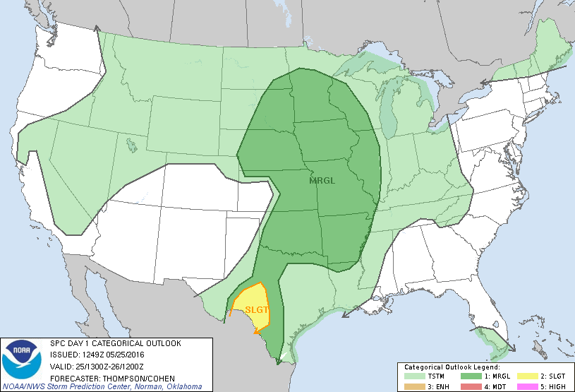
SPC Outlooks
| SPC EVENT REVIEW | ||
 |
 |
 |
| Figure 1: Overall Severe Outlook | Figure 2: Hail Outlook | Figure 3: Wind Outlook |
WPC Surface Analyses
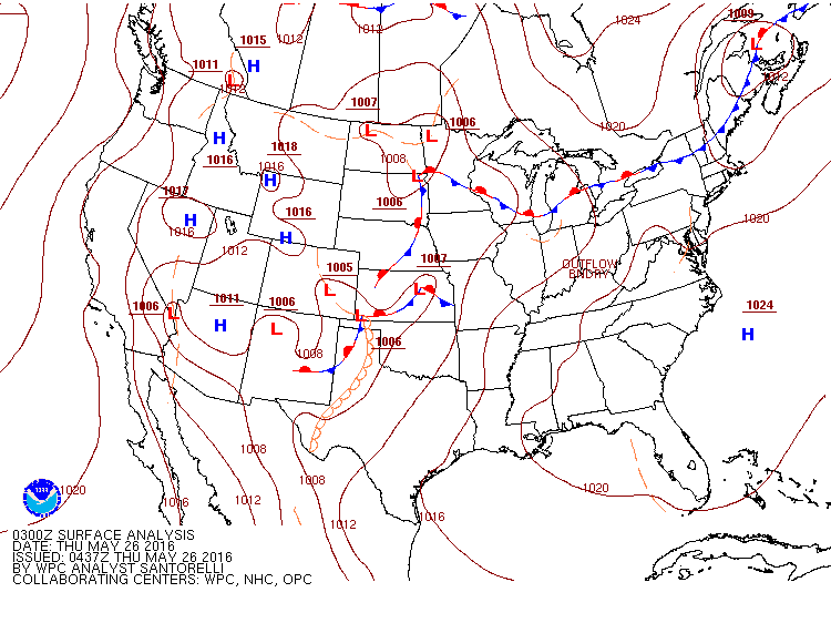 |
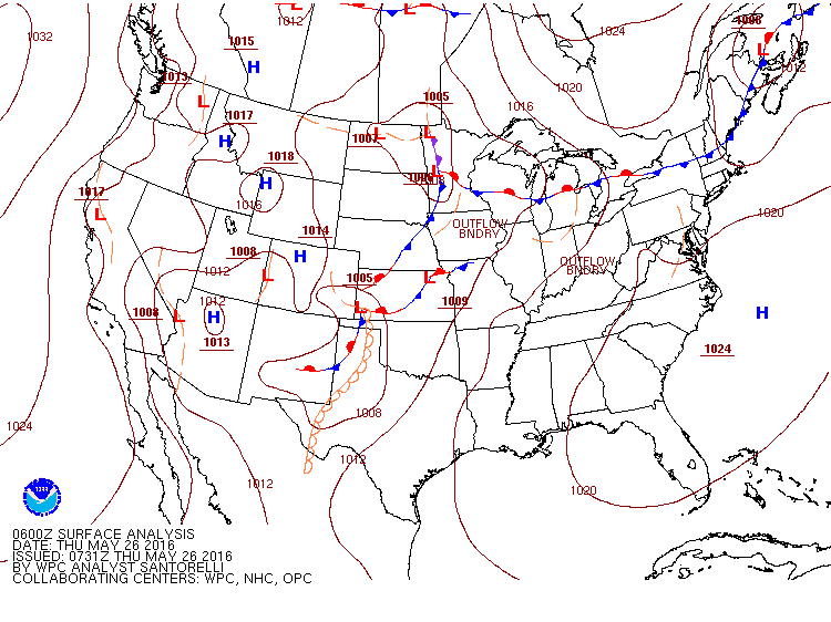 |
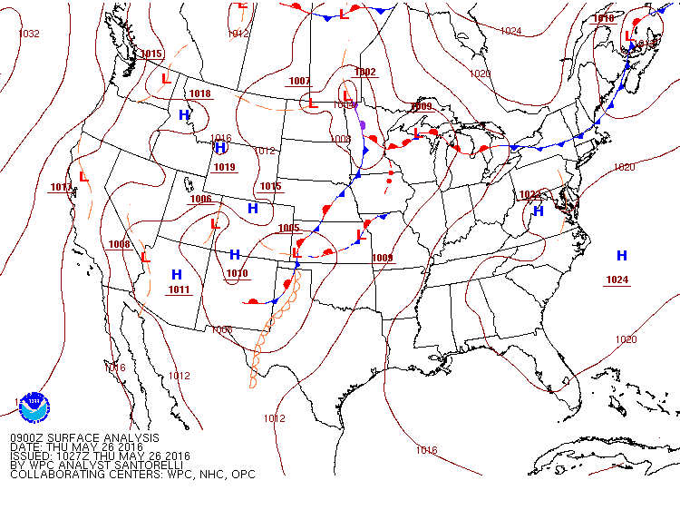 |
| Figure 4: 03z 5/26/16 Suface Map | Figure 4: 06z 5/26/16 Suface Map | Figure 4: 09z 5/26/16 Suface Map |
 |
Media use of NWS Web News Stories is encouraged! Please acknowledge the NWS as the source of any news information accessed from this site. |
|