Quad Cities, IA/IL
Weather Forecast Office
The National Weather Service (NWS) in the Quad Cities implemented the change to begin providing river forecast and warning services for two locations on the Cedar River in east central Iowa on January 15, 2019. These locations included:
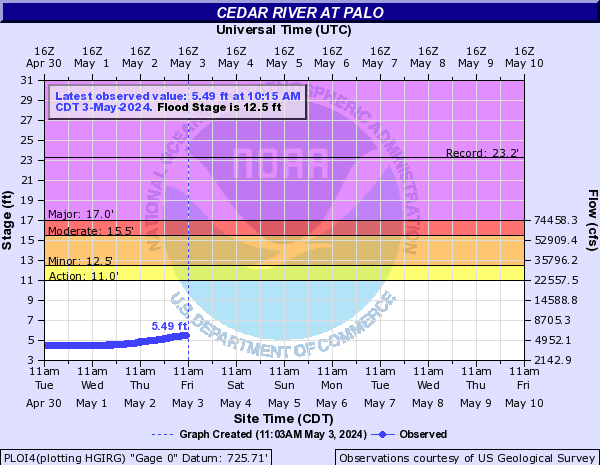
The Cedar River at Palo, IA on the Blairs Ferry Road bridge
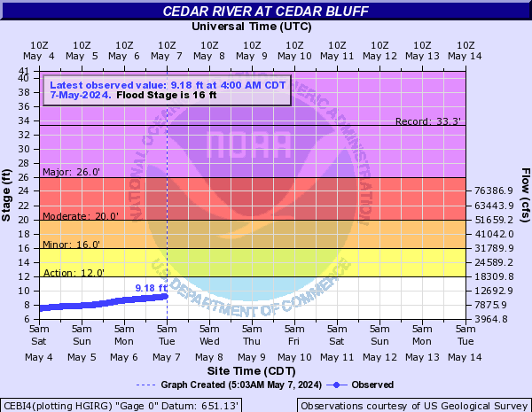
The Cedar River at Cedar Bluff, IA on the County Highway F28 bridge
The National Weather Service will provide river forecasts and statements, and watches and warnings as needed during times of high water for these two locations. These forecasts will be based upon observations provided at these gaging locations, which are operated and maintained by the U.S. Geological Survey (USGS).
Key stages have been identified for each locations as detailed below:
Cedar River at Palo, IA
Action Stage: 11.0 ft
Flood Stage (Minor Flood Stage): 12.5 ft
Moderate Flood Stage: 15.5 ft
Major Flood Stage: 17.0 ft
Cedar River at Cedar Bluff, IA
Action Stage: 12.0 ft
Flood Stage (Minor Flood Stage): 16.0 ft
Moderate Flood Stage: 20.0 ft
Major Flood Stage: 26.0 ft
Real-time observational data will continue to be displayed for these locations on the NWS Advanced Hydrologic Prediction Service (AHPS) webpage. Forecasts will be issued when the river level has reached, or is expected to reach or exceed the defined Action Stage. Watches and Warnings will be issued when the forecast is expected to reach or exceed the defined Flood Stage.
| Cedar River at Palo | Cedar River at Cedar Bluff |
 |
 |
Forecasts routinely incorporate 24 hours of forecast rainfall from April 1 through September 30, and 48 hours of forecast rainfall from October 1 through March 31.
The latest river stage and forecast information for these and other locations can be obtained from a variety of sources. These sources include:
Official Service Change Notice
Any questions or comments regarding these new services can be addressed to Jessica Brooks at the Quad Cities National Weather Service Forecast Office at 563-391-7094, or by email at jessica.brooks@noaa.gov.
Hazardous Weather
Watches, Warnings, & Advisories
Briefing
Hazards Page
View Local Storm Reports
Submit Report
Road Reports
Text Products
Forecasts
Fire Weather
Briefing
Hourly Forecast Graphs
Forecast Discussion
User-Defined Area
Activity Planner
Local Forecasts
Space Weather
Text Products
River Graphs
Airport Forecasts
Snow and Ice Probabilities
Winter Storm Severity Index (WSSI)
Current Conditions
Observations
Radar
Satellite
Rivers and Lakes
River Graphs
Road Reports
Drought Monitor
Text Products
Sunrise/Sunset Tables
Seasons (Equinoxes/Solstices)
Past Weather
Climate Maps
Climate Normals/Averages
Climate Records
Climate/Almanac Data
Recent Observation History
Climate Graphs
Climate Summaries
Observation Site History
Past Events
Text Products
Sunrise/Sunset Tables
US Dept of Commerce
National Oceanic and Atmospheric Administration
National Weather Service
Quad Cities, IA/IL
9040 N Harrison Street
Davenport Municipal Airport
Davenport, IA 52806-7326
563-386-3976
Comments? Questions? Please Contact Us.

