A Pacific storm system will bring low elevation/valley rain and mountain snow as it moves inland to the central Great Basin through the central Rockies through Thursday. Scattered thunderstorms are likely from California into the Great Basin. A large low pressure system continues to bring snow, blizzard conditions, damaging winds, and mixed precipitation along the Bering Sea and Southwest Alaska. Read More >
The Spring Flood and Water Resources Outlook is for the Quad Cities Hydrologic Service Area (HSA), which covers portions of eastern Iowa, northwest and west central Illinois, and extreme northeast Missouri.
This includes the Mississippi River from above Dubuque, Iowa to below Gregory Landing, Missouri and its tributaries.
The primary local river basins include the Maquoketa, Wapsipinicon, Cedar, Iowa, English, Skunk, North Skunk, and Des Moines Rivers in Iowa, the Fox River in Missouri, and the Pecatonica, Rock, Green, and La Moine Rivers in Illinois.
This outlook is for the time period from mid-March through mid-June.
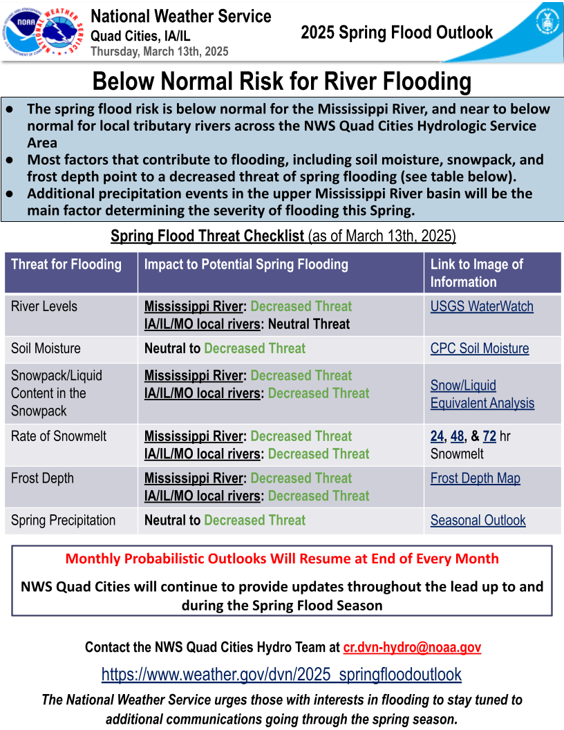
Spring Flood Outlook #3 (released 3/13/25)
Key Points
Most factors that contribute to flooding, including soil moisture, snowpack, and frost depth point to a decreased threat of spring flooding (see table below).
Additional precipitation events in the upper Mississippi basin will be the main factor determining the severity of flooding this spring.
Details
Some factors contributing to the current decreased risk levels include:
No snow on the ground and below normal precipitation throughout the local area and the headwater areas in Minnesota and Wisconsin.
Below normal soil moisture levels in the local area and across much of Minnesota and Wisconsin.
Deep frozen soils remain upstream, especially near the headwaters of the Mississippi River. Little to no frost remains locally across the Quad Cities Hydrologic Service Area (HSA).
Near to below normal streamflow throughout the local forecast area and in most of the upper Mississippi River Basin.
Through the spring, impacts from these factors are expected to change. One of the biggest factors that will drive any flood threat will be spring precipitation that we receive in the coming months, whether it be from rain or snow.
Many factors are considered when determining the overall flood risk for the upcoming spring season. The combination of these influences factor into the final determination. These factors are discussed in detail in the next few tabs and also in the Statistical Hydrological Outlook linked below.
________________________________________________________________________________________________________________
Use the links below to find the Graphical Probabilities and the Numerical Probabilities, respectively.
|
Graphical Hydrologic Outlooks |
Spring Flood Risk One-Pager (PDF)
(Mar 13, 2025) |
Statistical Hydrologic Outlook
(Mar 13, 2025) |
||||||
|
|
|
||||||
Current/Forecast River Conditions
| Current Conditions | Forecast Conditions | Long-Range Outlooks |
 |
|
|
Link To National Water Prediction Service (NWPS) and Additional River Forecast Resources
Flood Category Definitions
What Are The Risk Factors For Flooding?
Many factors are have been considered when determining the overall flood risk for the Spring, with the combination of these influences factoring into the final determination. These factors are discussed in detail below.
Seasonal Precipitation
Precipitation in eastern Iowa, northwest Illinois, and northeast Missouri has been below normal this winter. With that, much of the HSA, especially eastern Iowa and northwest Illinois, remains Abnormally Dry or in a Severe Drought due to below normal precipitation observed since the fall months in 2024. This is also reflected in soil moisture levels, which remain below normal. North of the area, precipitation in the upper Mississippi River Basin this winter has averaged below normal, aside from parts of far northern Minnesota, which are slightly above normal.
Latest outlooks from the Climate Prediction Center (CPC) favor near normal precipitation through the last half of March for all of the Upper Mississippi River Basin, with above normal precipitation favored for the month. Thus, guidance is highlighting the potential for an active month of weather. With dry soils and ongoing drought, any further precipitation should be allowed to infiltrate into the ground. Although, for areas where frozen soils remain up north, much of the late winter and early spring precipitation will translate to runoff, rather than easily infiltrate.
|
|
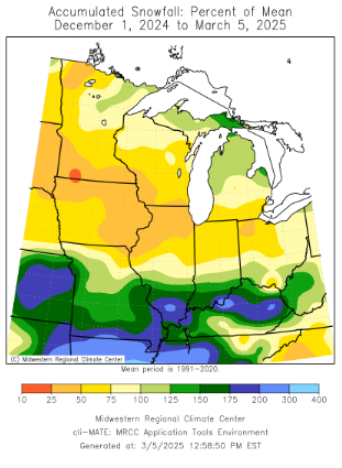 |
Below you will find the precipitation compared to normal in percentage. This graphic is courtesy of the High Plains Regional Climate Center.
 |
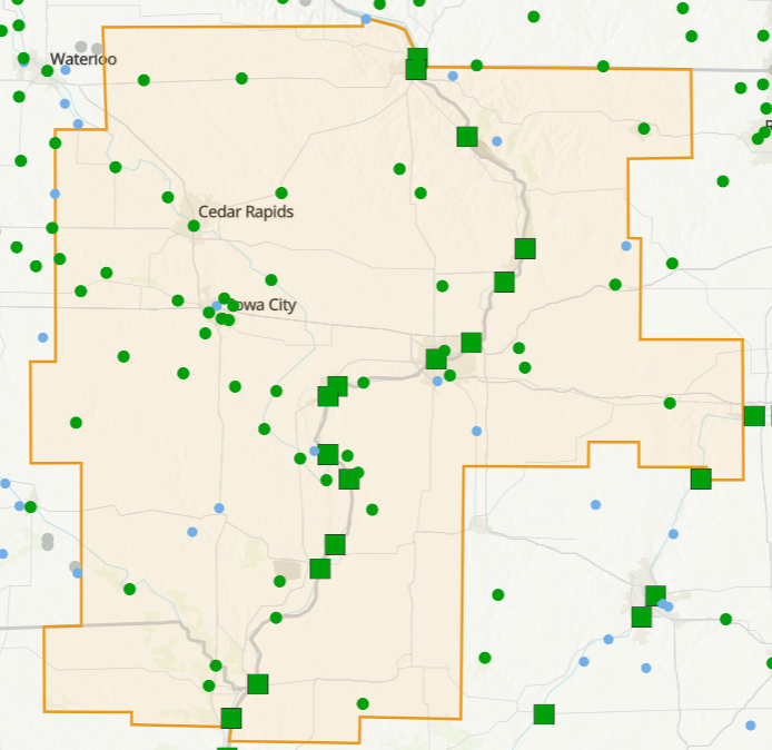
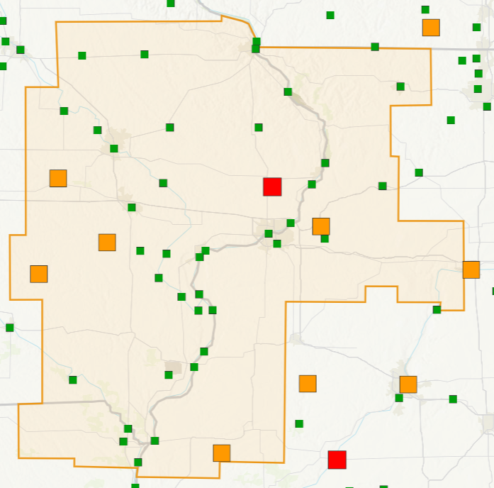
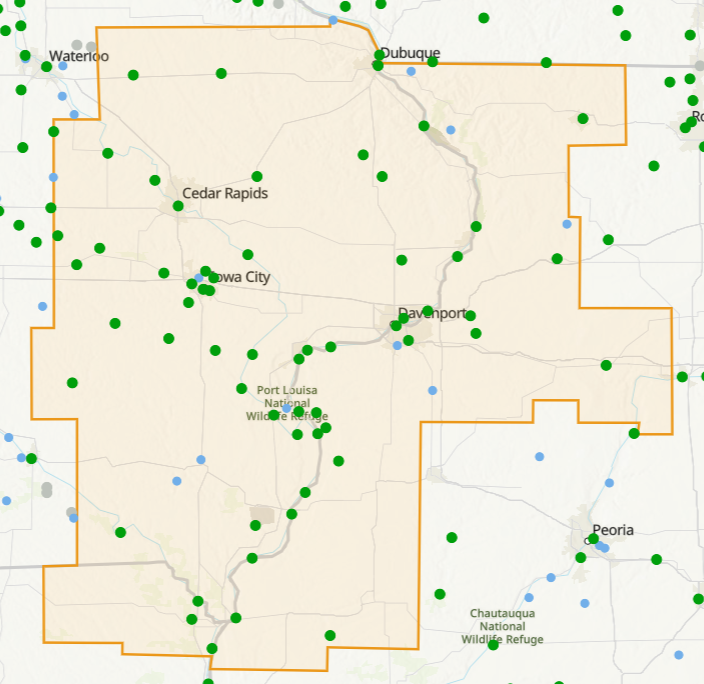
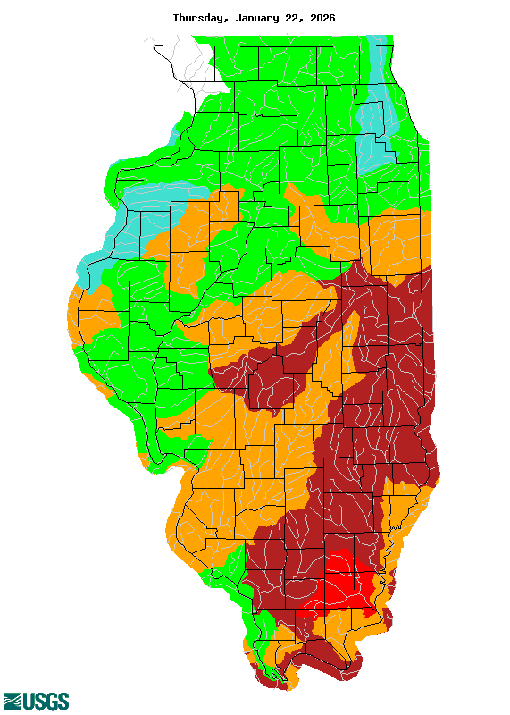
River Conditions
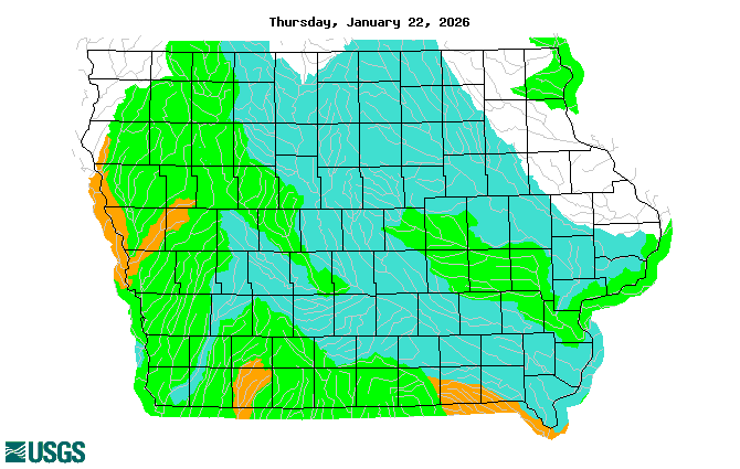
Streamflow analysis from the United States Geological Survey (USGS) indicates the majority of the Upper Mississippi River watershed and tributary streamflows are near to below normal. Locally, we have seen streamflows near normal in Iowa and near to below normal in Illinois. Streamflows that are below normal levels would have more capacity to hold runoff from heavy spring rains.
|
|
|

 |
 |
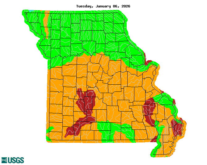 |
| Iowa | Illinois | Missouri |
| Images courtesy of the USGS |
Soil Conditions
Given the continuation of below normal precipitation since the fall, soil moisture levels remain below normal.
Latest analysis from the Climate Prediction Center shows soil moisture ranking profiles around 10-30% along
east of the Mississippi River, with near normal soil conditions as we head towards the Mississippi headwaters. We
continue to see widespread Abnormally Dry to Severe Drought conditions through the Upper Mississippi
River Valley. Considering these factors, they favor a neutral to decreased threat for spring flooding, as drier soils
will be better suited to soak in heavier rains once we lose the frost.
|
|
| Image courtesy of the NWS Climate Prediction Center |
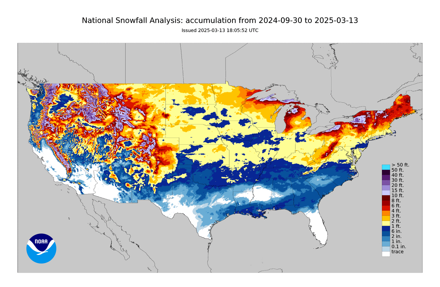
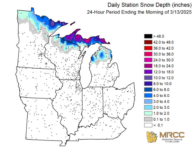
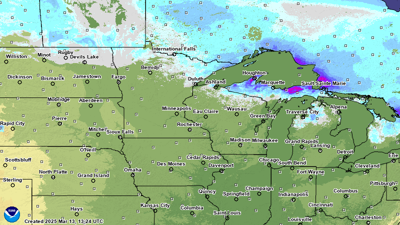
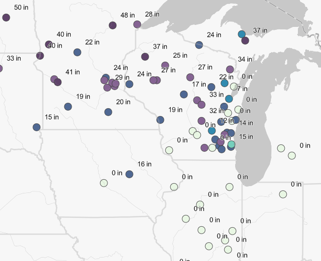
Snow Cover and Liquid Water Content
Recent above normal temperatures in the 1st half of March have melted all of the snow locally and most in the
upper Mississippi River basin. This has resulted in decreased threat to Spring flooding. Any additional snow
locally or upstream in the coming weeks, will have a minimal impact on Spring flooding for the remainder of the cold
season.
|
||
|
||
| Images courtesy of the Midwest Regional Climate Center (MRCC) and National Operational Hydrologic Remote Sensing Center (NOHRSC) |
Frost Depth
Recent above normal temperatures have resulted in losing most if not all of frost in the ground across
Iowa, Illinois, and Missouri. Upstream across Minnesota and Wisconsin, deep frost depths over 20
inches remain. Any precipitation that falls upstream on top of this frozen ground will increase runoff
into the mainstem Mississippi resulting in a neutral threat to Spring flooding.
| Frost Depths - North Central River Forecast Center | ||
Regional Frost Depths as of March 13, 2025 |
Ice Jam Flooding
Temperatures have been quite variable this winter, with stretches of cold resulting in plenty of river ice.
The recent stretch of warm weather has allowed for most of this ice to melt and/or breakup.
Current observations are indicating a low-medium threat for break up ice jams, but fortunately we are lacking
any heavy rain at the moment. This should mean that the ice can gradually melt/break up without many impacts.
Will continue to message a Neutral to Decreased Threat for ice jam flooding this Spring.
Looking Ahead
While active weather patterns are typical of the Spring months, this could lead to variations of warmer and
colder temperatures, where the risk for flooding will be determined by the tracks of individual and multiple
storm systems that could bring heavy rain or snow to parts of the region.

According to the latest outlooks from the Climate Prediction Center, probabilities are leaning toward above
normal temperatures and near to above normal precipitation for the last 2 weeks of March.

The outlook for March through May is showing no signal favoring above, near, or below normal temperatures
locally and for the upper Mississippi River basin and leaning towards above normal precipitation for the eastern
third of the upper Mississippi River basin.
Climate Outlooks
| 8 to 14 day Temperature Outlook | 8 to 14 day Precipitation Outlook |
 |
 |
|
Feb-Mar-Apr Temperature Outlook |
Feb-Mar-Apr Precipitation Outlook |
 |
 |
River and Streamflow Information:
Flood safety and flood insurance information:
Precipitation, temperature, and soil moisture information:
Questions or Comments
If you have questions or comments about this spring flood and water resource outlook please contact:
National Weather Service Quad Cities Hydrology Team
9040 Harrison St
Davenport, IA 52806
Email: cr.dvn-hydro@noaa.gov
 |
Media use of NWS Web News Stories is encouraged! Please acknowledge the NWS as the source of any news information accessed from this site. |
|