A long-lived storm system brought heavy amounts of snow to the region Tuesday and Wednesday December 8-9th. In addition to the heavy snow, blizzard conditions spread over much of the area Wednesday. Snowfall was heaviest from southwest Iowa through southern Wisconsin, where amounts of 12 to 15 inches were common. Significant snows were also found farther south, through the Quad Cities and southeast Iowa, where amounts ranged from six inches to upwards of one foot.
Early on Tuesday the 7th, the developing low pressure spread light snow across eastern Iowa, northwest Illinois, and northeast Missouri. Accumulations by the afternoon were less than an inch east of the Mississippi River, around 2 inches along the river, and 3+ inches across portions of east central Iowa. At this time, warmer air aloft began to wrap around the low pressure, which was located in central Missouri. This resulted in a change to mixed precipitation (snow, sleet, and freezing rain) along and east of the Mississippi. Western Illinois changed to all rain, with Macomb totaling over a half inch of liquid. Farther northwest, freezing rain coated elevated surfaces with anywhere from 0.10" to 0.30" of ice along a line from Burlington, IA to Sterling, IL. To the northwest of that line sleet was common, even being reported as far west as Cedar Rapids. However, across east central Iowa, northeast Iowa and extreme northwest Illinois the precipitation remained all snow. This included reports of thundersnow in Vinton, IA and Ridott, IL as the low pressure began to strengthen rapidly in the vicinity of Peoria, IL.
Early Wednesday the 8th, the low pressure was continuing its explosive strengthening, and air began to rush towards the center. This meant strong winds out of the north, then northwest, began to blow across eastern Iowa. Sustained winds between 25 and 35 mph, with higher gusts, started to blow and drift the freshly fallen snow. Meanwhile, heavy snow continued in a band from east central Iowa, through the Quad Cities, and up into northwest Illinois and southern Wisconsin. By late morning blizzard conditions were being felt across most of the upper Midwest. It was no different throughout eastern Iowa, northwest Illinois, and northeast Missouri. In rural areas blowing and drifting was widespread, with frequent whiteout conditions common, especially west of the Mississippi River. All the while heavy snow continued to further restrict visibility. Despite the storm being over northern Lower Michigan these winds and the snow continued into the early evening. Final accumulations ranged from as little as 1 inch, to over 15 inches, and are included below. As one final display, the departing storm also brought down bitterly cold air into the region. The airmass blasted through, dropping temperatures from near 32 degrees at midnight, to the single digits by Wednesday afternoon.
 |
 |
 |
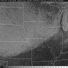
| Visible Satellite Image (Thursday 12/10/9). White areas show snow. |
Estimate of Iowa Snow Totals | Estimate of Illinois Snow Totals |
|
Area Snowfall Amounts INCHES LOCATION ST COUNTY ------ ----------------------- -- ------------ 15.3 BRIGHTON IA WASHINGTON *official observation 15.0 3 NW MT VERNON IA LINN 15.0 FREEPORT IL STEPHENSON 14.0 PEARL CITY IL STEPHENSON 13.5 E SOLON IA JOHNSON 13.3 VINTON IA BENTON 13.0 3 N STOCKTON IL JO DAVIESS 13.0 4 WSW STANLEY IA BUCHANAN *official observation 12.5 S MOUNT AUBURN IA BENTON 12.5 SSE ATKINS IA BENTON 12.5 1 SSW BELLE PLAINE IA BENTON 12.5 W ELIZABETH IL JO DAVIESS 12.0 2 NW MARION IA LINN 12.0 VICTOR IA IOWA 11.9 DAVENPORT MUN. AIRPORT IA SCOTT *official observation 11.6 1 NW CEDAR RAPIDS IA LINN 11.5 WNW PARNELL IA IOWA 11.0 CASCADE IA DUBUQUE *official observation 10.8 5 NW CEDAR RAPIDS IA LINN 10.5 LOWDEN IA CEDAR *official observation 10.5 DUBUQUE AIRPORT IA DUBUQUE *official observation 10.0 3 W SUNBURY IA CEDAR 9.0 ANAMOSA IA JONES 9.0 5 NNW LANARK IL CARROLL 9.0 4 E WHAT CHEER IA KEOKUK 8.5 CEDAR RAPIDS IA LINN 8.5 4 NW STERLING IL WHITESIDE 8.4 MOLINE QUAD-CITY AIRPORT IL ROCK ISLAND *official observation 8.1 ERIE IL WHITESIDE 7.2 CORDOVA IL ROCK ISLAND 7.0 2 E BECKWITH IA JEFFERSON 7.0 1 N BURLINGTON IA DES MOINES 5.5 1 SE PRINCETON IL BUREAU 5.0 W CANTRIL IA VAN BUREN 3.9 MALDEN IL BUREAU 2.8 3 NNE CHARLIE HEATH MEM IA VAN BUREN 2.0 ESE MONMOUTH IL WARREN 1.0 1 SSW MACOMB IL MCDONOUGH |
||
Though the snowfall totals listed above are impressive, did you know that a blizzard has nothing to do with the amount of snow you measure? The official definition of a blizzard is, "winds of 35 mph or more with snow and/or blowing snow reducing visibility to less than 1/4 mile for at least 3 hours."
The pictures below provide a snipet of what conditions were like for the evening shift, as they showed up to work on Wednesday afternoon.
A heavy, wet snow had coated almost everything in sight the night before, and now was frozen in place.
Heading to the front door is a chore with west winds blowing straight down the walkway.
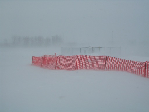
A newly installed snow fence was doing its job, keeping the entrance to the parking lot (relatively) snow free.
A far larger snow drift had piled up by the snow fence protecting the entrance to the airport road, as the sun began to peek through the heavy snow squalls.
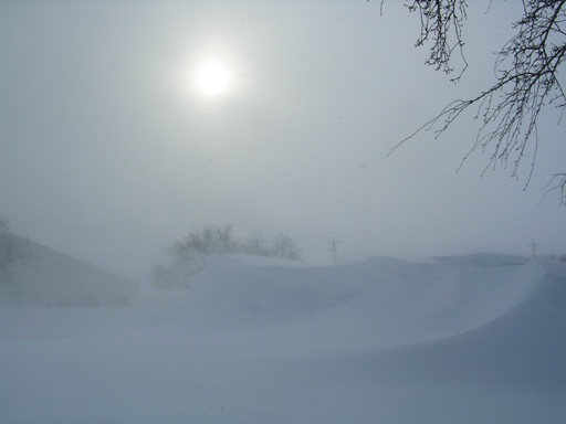
Across the wind swept field less than 100 yards north of the office, the weather balloon inflation building suddenly seemed very far away.
The above pictures were taken standing in the same location, at roughly 2pm, 24 hours apart. On the left is the field west of the office on Thursday afternoon, with the Davenport Municipal Airport terminal buildings in the distance. The buildings are a little over 500 feet away. On the right is the same photograph taken on Wednesday afternoon, during some of the worst blizzard conditions. The grass only a few feet away is greatly obscured, and with some really good eyesight one can make out the ghostly sillouette of the airport signal tower. This is just an example of conditions experienced across most of the forecast area.


.jpg)
.jpg)