Quad Cities, IA/IL
Weather Forecast Office
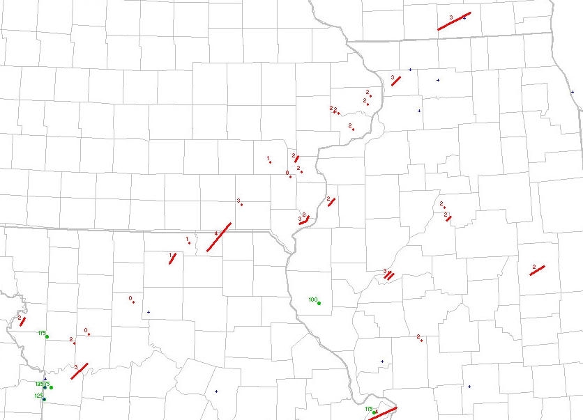
A classic "synoptically evident" severe weather pattern developed over the Midwest in late January 1967. The storm system produced significant tornadoes (F2+) across northern Missouri, eastern Iowa, northwest and central Illinois, and even in south-central Wisconsin during the late afternoon of January 24, 1967. The tornadoes developed as a broken line of supercells along a surface cold front. This was one of the most significant outbreaks in NWS Quad Cities, IA/IL modern county warning area (CWA) history with 1 fatality, 25 injuries, and one of the strongest tornadoes known to have occurred in the CWA.
 |
| Tornado tracks across northern Missouri, eastern Iowa, northwest and central Illinois, and south-central Wisconsin |
Tornadoes F2 and greater that occurred in the NWS Quad Cities, IA/IL CWA:
| 1. | F4 - Schuyler to Scotland, MO to Davis, IA - destroyed 5 farms, leveling 2 entirely, and damaged 20 more, 2 injuries |
| 2. | F2 - Van Buren to Jefferson, IA - homes unroofed and barns destroyed south and east of Fairfield, IA |
| 3. | F3 - Lee, IA - destroyed 2 homes and caused 1 fatality and 6 injuries - just northwest of Ft. Madison, IA |
| 4. | F2 - Louisa, IA - destroyed barns and wall of a home west of Wapello,IA 1 injury |
| 5. | F3 - Lee IA - barns and trailers destroyed and homes unroofed southeast of Wever,IA 4 injuries (in trailers) |
| 6. | F2 - Muscatine,IA - home unroofed west of Muscatine |
| 7. | F2 - Henderson,IL - just southeast of Gladstone, many farm buildings destroyed |
| 8. | F2 - Rock Island,IL - farm house unroofed and several damaged in Illinois City, IL |
| 9. | F3 - Carroll,IL -3 homes destroyed (near F4 damage) plus extensive barn and roof damage, moved through Mt. Carroll,IL 12 injuries |
| 10. | F2 - Scott,IA -northwest of Mt. Joy,IA barns destroyed and house windows blow out, vehicles blown off road |
| 11. | F2 - Clinton,IA -some buildings destroyed and others nearly unroofed near Bryant,IA |
In Missouri, Iowa, Illinois, and Wisconsin, a total of 7 people were killed during the tornado outbreak. Five deaths occurred in Missouri, one death in Iowa, and one death in Illinois.
Within 36 hours following the tornado outbreak, freezing rain and snow began to fall over the region. There were 24 hour record snow accumlations, with high winds creating blizzard conditions. In Burlington, Iowa there was 13.5 inches of snow that fell on January 26, 1967.
|
Date |
Snow (inches) |
High Temperature (°F) |
|
23 |
0 |
55 |
|
24 |
0 |
65 |
|
25 |
Trace |
31 |
|
26 |
13.5 |
28 |
Hazardous Weather
Watches, Warnings, & Advisories
Briefing
Hazards Page
View Local Storm Reports
Submit Report
Road Reports
Text Products
Forecasts
Fire Weather
Briefing
Hourly Forecast Graphs
Forecast Discussion
User-Defined Area
Activity Planner
Local Forecasts
Space Weather
Text Products
River Graphs
Airport Forecasts
Snow and Ice Probabilities
Winter Storm Severity Index (WSSI)
Current Conditions
Observations
Radar
Satellite
Rivers and Lakes
River Graphs
Road Reports
Drought Monitor
Text Products
Sunrise/Sunset Tables
Seasons (Equinoxes/Solstices)
Past Weather
Climate Maps
Climate Normals/Averages
Climate Records
Climate/Almanac Data
Recent Observation History
Climate Graphs
Climate Summaries
Observation Site History
Past Events
Text Products
Sunrise/Sunset Tables
US Dept of Commerce
National Oceanic and Atmospheric Administration
National Weather Service
Quad Cities, IA/IL
9040 N Harrison Street
Davenport Municipal Airport
Davenport, IA 52806-7326
563-386-3976
Comments? Questions? Please Contact Us.

