A vigorous storm system swept into the plains on Saturday April 14, 2012 and helped to produce numerous tornadoes across the state of Kansas, including 16 tornadoes in the area that the Dodge City office serves. Thunderstorms developed rapidly during the mid-morning hours from near Liberal to Hays and intensified as the day progressed, some producing tornadoes.
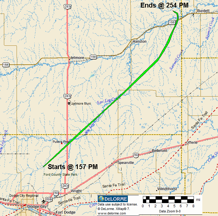
HANSTON TORNADO (EF1)
One tornado developed 6 miles north-northeast of the Dodge City post office at 157 PM. The developing stages of the parent circulation had actually started near the Boot Hill Casino and United Events Arena just west of town and passed over the Dodge City high school where a band program was in progress.
The tornado ended at 254 PM three miles west of Burdett. The total path length was around 33 miles and had an approximate width of 150 yards at it's largest. This tornado was rated as a high wnd EF1 on the Enhanced Fujita Scale with winds perhaps as strong as 105 MPH.
Or open this KML map in Google Earth for more detail...
Also, try this "fly over" using Google Earth...NOTE: You must click on the detailed map first.
FELLSBURG TORNADO (EF3)
Another tornado developed after dark and was eerily similar to the Greensburg tornado of May 4,2007. In fact this large tornado that developed west of Greensburg on the 14th traveled across some of the same area that was hit in 2007! The tornado started at 827 PM 4.4 miles west of Greensburg and quickly grew in size. The tornado traveled 38.0 miles and was 1 mile wide at times. It did significant damage to a few homes, power poles, trees, outbuildings and equipment and pivot irrigation sprinklers. It had been on a direct path for Macksville in Edwards county but shifted east slightly. This tornado was rated as a low end EF3 on the Enhanced Fujita scale with winds perhaps as strong as 140 MPH.
Click the map for a larger version

Or open this KML map in Google Earth for more detail...
SAINT JOHN TORNADO (EF3)
As the previous tornado was dissipating northeast of Macksville, a third and even larger tornado was developing just east-southeast of town at approximately 910 PM.. This tornado grew very rapidly as it traveled northeast. Thankfully it passed just northwest of St. John and just south of Hudson before it moved over the Great Salt Marsh at the Quivira National Wildlife Refuge and moved into Rice county at 945 PM. The tornado continued northeast narrowly missing Raymond and dissipated west of Lyons. The tornado had a total path length from start to finish of 42 miles and had a maximum width of an astonishing 1.5 miles! This tornado was rated as a low end EF3 on the EF scale with winds perhaps as strong as 140 MPH.
Click the map for a larger version

Or open this KML map in Google Earth for more detail...
Also, try this "fly over" using Google Earth...NOTE: You must click on the detailed map of the "Big 2" first.
In all there were 16 confirmed tornadoes. The map of the tracks follows (click for a larger version):

Or open this KML map in Google Earth for more detail...
The following is a selection of Images taken by Warning Coordination Meteorologist Jeff Hutton (click for a larger version):


(last updated April 30, 2012)

