Heat expands across the Desert Southwest, Plains, Mississippi Valley and Midwest into Monday. Fire weather concerns continue for portions of the Intermountain West. Active monsoonal moisture fuels thunderstorms over the Southwest with possible flash flooding. Tropical cyclone Fausto in the Pacific, should weaken as it approaches Hawaii; Dangerous surf, swells and rip currents are expected. Read More >
Fall Freeze Climatology For
Central & Southwest Kansas
Light Freezes
For the purposes of this article, a light freeze is defined as a temperature of 32 ̊ F. The date of the first light freeze is highly variable across southwest and central Kansas. Keep in mind that official temperatures are measured at 2 meters (~ 6.5 feet) above the ground. On clear nights with light winds, the coldest temperatures are close to ground level. Therefore, frost can occur at the ground while temperatures two meters above the ground are above freezing. The earliest freezes historically have been in September while the latest occurred in mid-November.
The typical light freeze occurs as surface high pressure settles across the high plains well after a cold frontal passage. In these instances, winds weaken to less than 10 mph and skies are often clear, resulting in a long night of strong “radiational cooling”. In such cases, low-lying areas tend to experience freezing temperatures quicker while locations on hills can stay several degrees warmer. An example of this is along the Arkansas River valley across Gray and Ford counties where temperatures are often 5 ̊ F (or more) colder on windless mornings than on the nearby hills. The National Weather Service office in Dodge City is on a hill at 2,590 feet elevation and generally stays warmer in these situations while two miles south of the office at the river bottom the elevation is 2,460 feet. This difference in elevation of 130 feet can make a tremendous difference in temperature in light wind situations at night. An example of this occurred on 3 September 1974 when the temperature not far from the Arkansas River bottom at Cimarron plunged to 29 degrees while the National Weather Service office near the airport in Dodge City bottomed out at 42.
Less frequently, first freezes can occur in the wake of a cold front with strong north winds and cloud cover, and sometimes even precipitation. Radiational cooling is much less of a factor in these situations and it takes a much colder air mass to get early fall freezes from “cold advection” (cold air rushing into the area from the north) processes as opposed to radiational cooling. One example of this occurred on 21 September 1995. This was the first cold snap of the fall and the first 32 ̊ reading occurred while snow was falling. The snow accumulated to between 1 and 2” in Ford county. Another example occurred on 23 October 2020 when Dodge City reached the freezing point with 25 mph north winds and cloudy skies.
Aside from terrain effects (river valleys versus hills), the light autumn freezes generally occur earlier across west-central Kansas than across south central Kansas. Therefore, expect locations such as Syracuse, Scott City, and Lakin to generally have earlier freezes than Pratt, Medicine Lodge and Coldwater.
In some instances, the early autumn light freeze does not materialize and the first freeze is a hard freeze. Note that even if the official temperature measured at 2 meters (~ 6.5 feet) above the ground only gets down to 33 or 34 ̊ F, the temperature near the ground can be 32 ̊ F or colder, resulting in frost. This is especially true along creek beds.
Average first freeze (32 ̊ ) dates
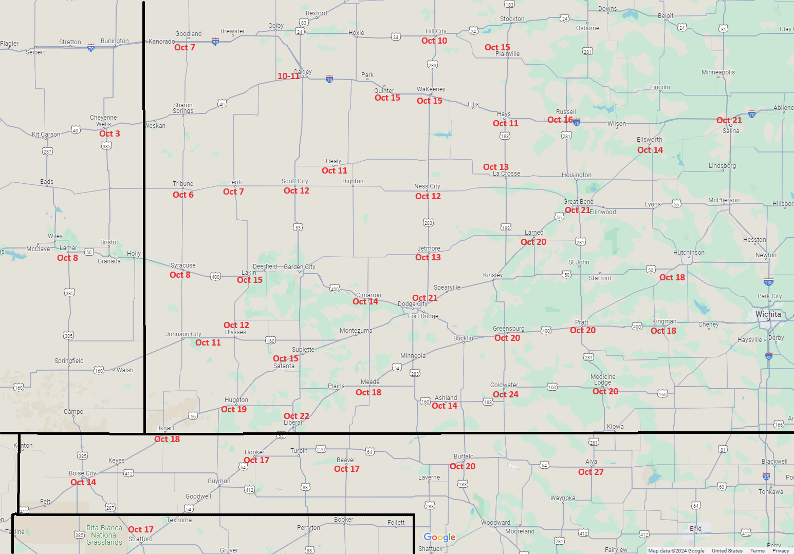
The map below shows average freeze dates across central and southwest Kansas. Note that this map is not contoured since there can be strong variability near river valleys.
Extreme Western Kansas (Light freeze)
Locations in extreme western Kansas such as Syracuse, Tribune and Leoti have similar average freeze dates on 7 October and 8 October. Note that cooperative observer data for Syracuse only go back to 1937. However, overlapping data for Coolidge, KS and Holly, CO indicate similar freeze dates at all three locations so that data sets for these locations were combined to form a longer climatology for Hamilton county back to 1894 as shown on the graph below. Note that the earliest freeze occurred on 3 September 1974 and the latest occurred on 7 November 2015. Between the 10th and 90th percentiles one can see that the first freeze occurred between 21 September and 20 October 80% of the time, 10% occurring earlier and 10% occurring later. Thus, one can expect the first freeze to fall between these dates the vast majority of the years. The 25th and 75th percentiles are 29 September and 13 October, meaning that the first freeze occurs between these two dates 50% of the years.

West-central Kansas (Light freeze)
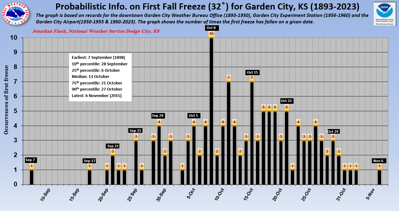
For the purpose of this article, we consider west-central Kansas as including locations such as Scott City, Healy, Lakin, Johnson, Cimarron and Garden City. All of these locations have average first freeze dates that are within a few days of each other. As an example, we use data for Garden City as shown in the graph below. The average date of first freeze at Garden City is 13 October. Other west-central Kansas locations indicate average freeze dates of 11 October (Healy), 14 October (Lakin), 14 October (Cimarron) and 12 October (Scott City). For Garden City, note that the earliest freezes occurred on 7, 17 and 21 September and the latest occurred on 6 November. Between the 10th and 90th percentiles one can see that the first freeze occurs between 28 September and 27 October 80% of the time, 10% occurring earlier and 10% occurring later. Thus, one can expect the first freeze to fall between these dates the vast majority of the years. The 25th and 75th percentiles are 6 October and 21 October, meaning that the first freeze occurs between these two dates 50% of the years.
Southwest Kansas (Light freeze)
For the purpose of this article, we define southwest Kansas as including locations such as Dodge City, Sublette, Cimarron, Jetmore, Larned, Greensburg and Ashland. As previously mentioned, observations were taken on a hill at the airport in Dodge City since the 1940s so that average freeze dates are later here compared to the river valley locations such as Jetmore and Cimarron and other low spots such as Ashland.
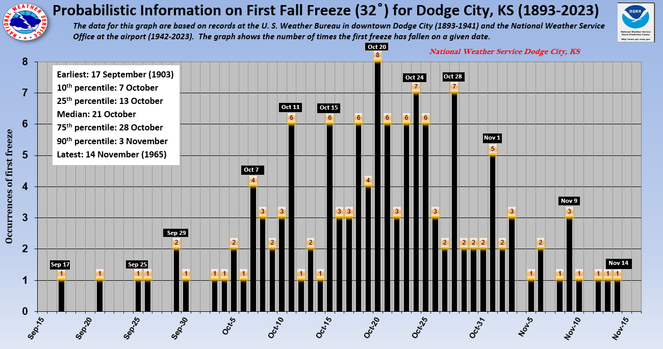
The average date of first freeze at Dodge City is 21 October. Other southwest Kansas locations indicate average freeze dates of 18 October (Meade), 20 October (Greensburg), 20 October (Larned), 15 October (Sublette) and 14 October (Ashland). On the graph for Dodge City shown below, note that the earliest freezes occurred on 17, 21 and 25 September and the latest occurred on 14 November. Between the 10th and 90th percentiles one can see that the first freeze occurs between 7 October and 3 November 80% of the time, 10% occurring earlier and 10% occurring later. Thus, one can expect the first freeze to fall between these dates the vast majority of years. Again, the dates of first freeze are spread out over a long period so that the average freeze date can be misleading. The 25th and 75th percentiles are 13 October and 28 October, meaning that the first freeze occurs between these two dates 50% of the years.
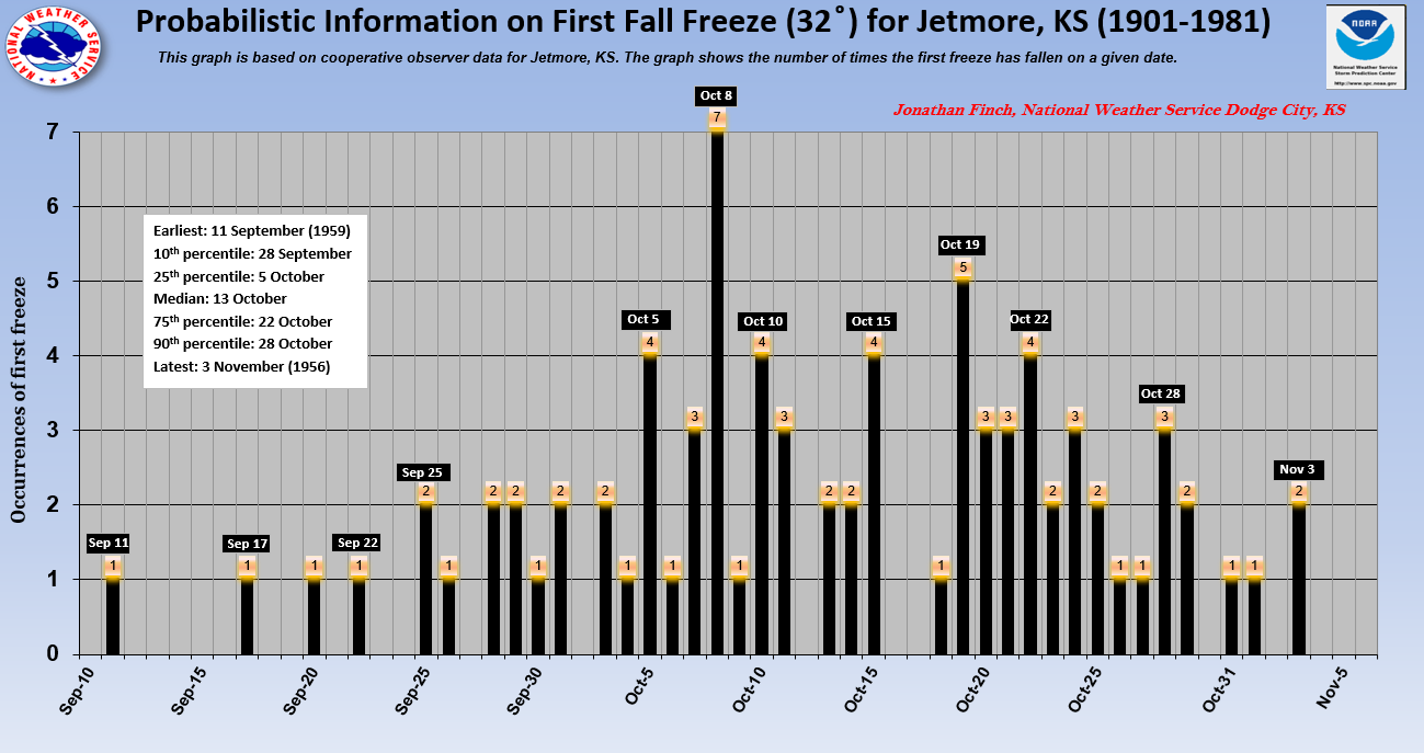
The graph for Jetmore is shown below. Being in a low spot along Buckner Creek, the average freeze date is about a week earlier at Jetmore than Dodge City.
Central Kansas (Light freeze)
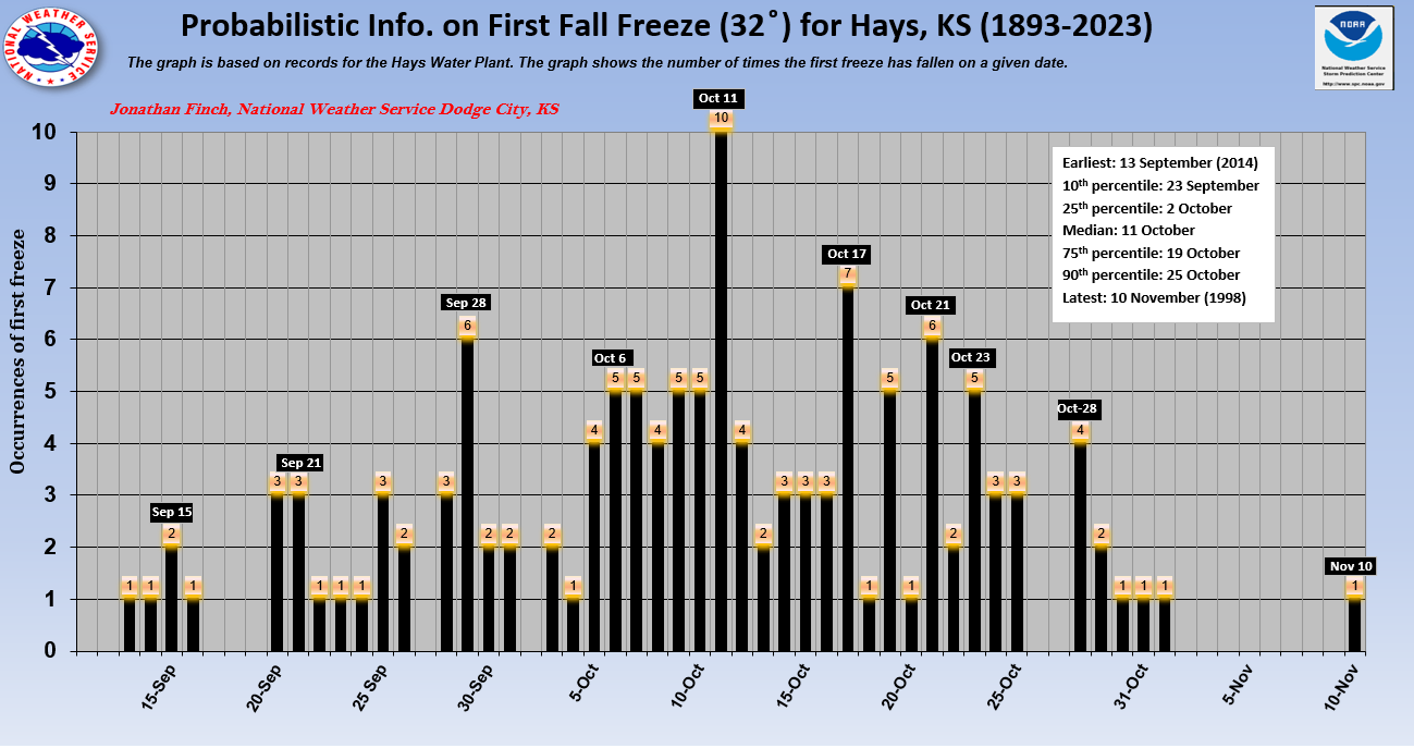
For the purpose of this article, we define central Kansas as including locations such as Hays, La Crosse and St. John. The average date of first freeze at Hays is 11 October. The average freeze date at La Crosse is 12 October. On the graph for Hays shown below, note that the earliest freeze occurred on 13, 14, 15 and 16 September and the latest occurred on 10 November. Between the 10th and 90th percentiles one can see that the first freeze occurs between 23 September and 25 October 80% of the time, 10% occurring earlier and 10% occurring later. Thus, one can expect the first freeze to fall between these dates the vast majority of the years. The 25th and 75th percentiles are 2 October and 19 October, meaning that the first freeze occurs between these two dates 50% of the years.
South Central Kansas (Light freeze)
For the purpose of this article, we define south-central Kansas as including locations such as Pratt, Medicine Lodge and Coldwater. The average freeze dates are 24 October (Coldwater), 20 October (Pratt) and 20 October (Medicine Lodge). On the graph for Pratt shown below, note that the earliest freezes occurred on 20, 21, and 22 September and the latest occurred on 16 November. Between the 10th and 90th percentiles one can see that the first freeze occurs between 7 October and 4 November 80% of the time, 10% occurring earlier and 10% occurring later. Thus, one can expect the first freeze to fall between these dates the vast majority of the years. The 25th and 75th percentiles are 11 October and 28 October, meaning that the first freeze occurs between these two dates 50% of the years.
.png)
Hard Freezes
For the purposes of this article, a hard freeze is defined as 26 ̊ F. On average, the first hard freeze is about two weeks after the first light freeze. The first hard freeze generally occurs earlier in the fall across west central Kansas than over south central Kansas.
Average First Hard Freeze (26 ̊ ) dates
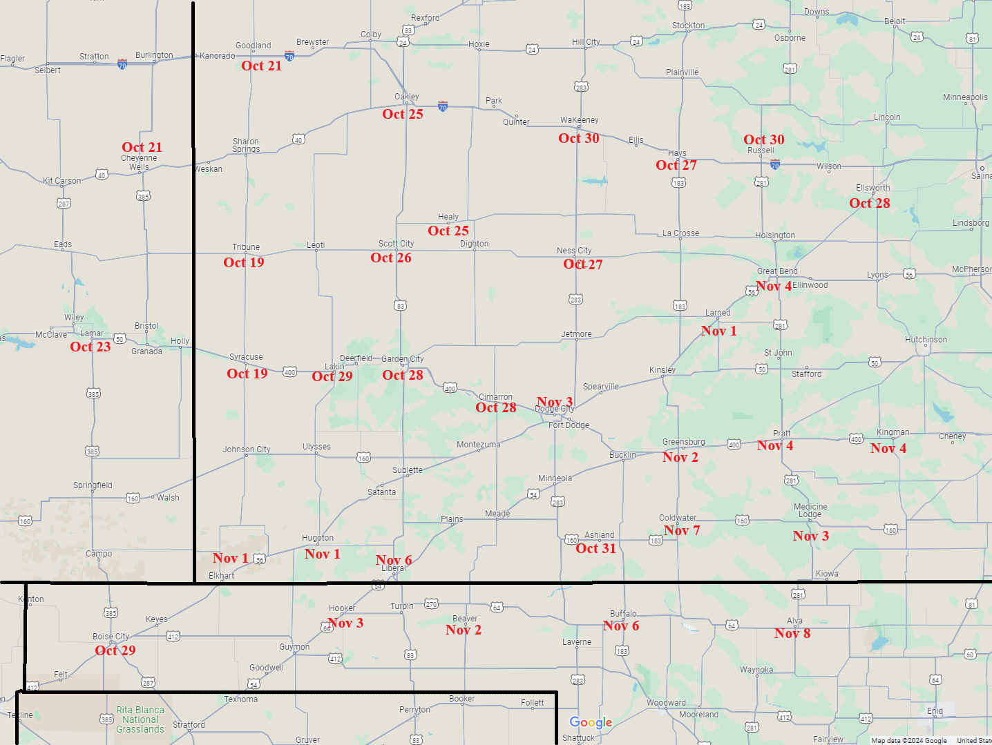
The map below shows average hard freeze dates across central and southwest Kansas. Note that this map is not contoured since there can be strong variability near river valleys.
Extreme Western Kansas (hard freeze)
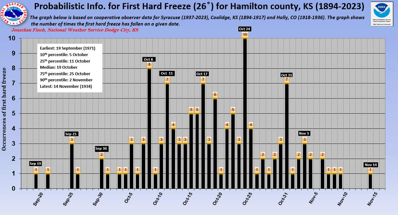
On average, locations across extreme western Kansas typically experience a hard freeze (26 ̊ ) between 19 and 22 October as evidenced by cooperative observer data for Syracuse, Hamilton county in general, and Leoti. The graph below displaying probabilistic information shows the average date of first hard freeze on 19 October for Hamilton county. However, as with the light freezes, there is high intra-seasonal variability with hard freeze dates. Note that the earliest hard freezes occurred on 19 and 21 September and the latest occurred on 9 and 14 November. Between the 10th and 90th percentiles one can see that the first hard freeze occurs between 5 October and 2 November 80% of the time, 10% occurring earlier and 10% occurring later. Thus, one can expect the first hard freeze to fall between these dates the vast majority of the years. The 25th and 75th percentiles are 11 October and 25 October, meaning that the first freeze occurs between these two dates 50% of the years.
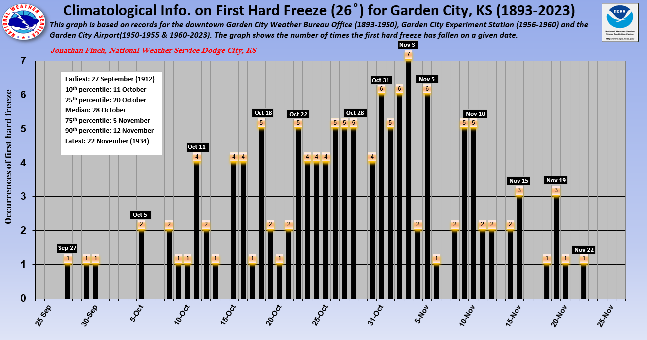
West-central Kansas (hard freeze)
The graph below showing probabilistic hard freeze information for Garden City is fairly representative of other locations such as Scott City, Lakin, Healy and Cimarron. Note that the earliest freezes occurred on 27, 29 and 30 September and the latest occurred on 22 November. Between the 10th and 90th percentiles one can see that the first hard freeze occurred between 11 October and 12 November 80% of the time, 10% occurring earlier and 10% occurring later. Thus, one can expect the first hard freeze to fall between these dates the vast majority of the years. The 25th and 75th percentiles are 20 October and 5 November, meaning that the first freeze occurs between these dates 50% of the years. And of course, there is considerable variability in timing of the first hard freeze.
Southwest Kansas (hard freeze)
Hard freeze dates across southwest Kansas are earlier in river valleys. The date of hard freeze in the river bottoms of Ford, Gray and Hodgeman counties will average about a week earlier than on the adjacent hills. The graph below shows the probabilistic hard freeze information at the Dodge City airport. Note that the earliest freezes occurred on 8, 10, 11 and 12 October and the latest occurred on 27 November and 7 December. Between the 10th and 90th percentiles one can see that the first hard freeze occurs between 20 October and 16 November 80% of the time, 10% occurring earlier and 10% occurring later. Thus, one can expect the first hard freeze to fall between these dates the vast majority of the years. The 25th and 75th percentiles are 26 October and 10 November, meaning that the first hard freeze occurs between these dates 50% of the years. However, this graph shows that there is considerable variability in timing of the first hard freeze.

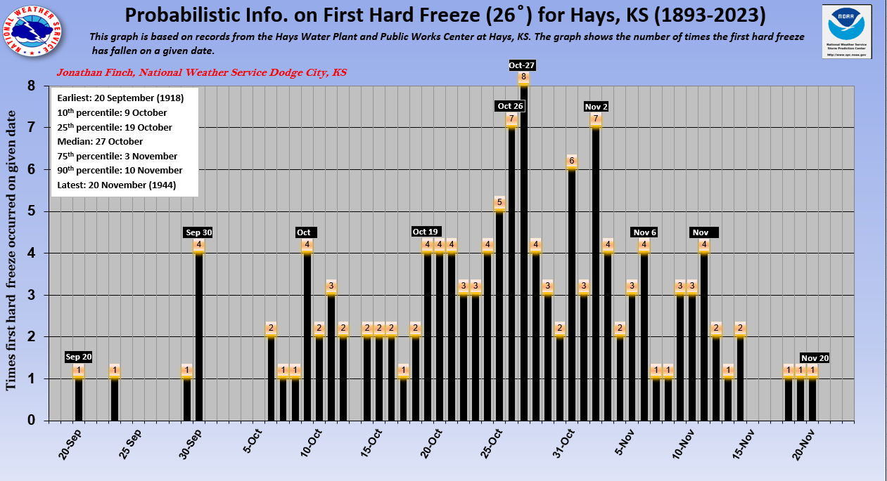
Central Kansas (hard freeze)
As shown in the graph below showing probabilistic hard freeze information, the average date of first hard freeze at Hays is 27 October. Note that the earliest freezes occurred on 20, 23, 29 and 30 September and the latest occurred on 18, 19 and 20 November. Between the 10th and 90th percentiles one can see that the first hard freeze occurs between 9 October and 10 November 80% of the time, 10% occurring earlier and 10% occurring later. Thus, one can expect the first freeze to fall between these dates the vast majority of the years. The 25th and 75th percentiles are 19 October and 3 November, meaning that the first hard freeze occurs between these two dates 50% of the years.
South Central Kansas (hard freeze)
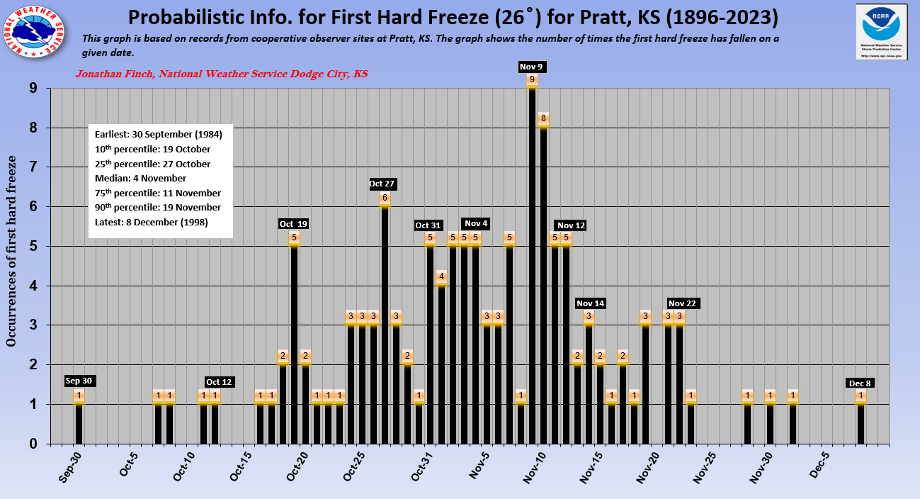
On the graph for Pratt shown below, note that the earliest hard freezes occurred on 30 September and 7 October and the latest occurred on 2 December and 8 December. Between the 10th and 90th percentiles one can see that the first hard freeze occurred between 19 October and 19 November 80% of the time, 10% occurring earlier and 10% occurring later. Thus, one can expect the first hard freeze to fall between these dates the vast majority of the years. The 25th and 75th percentiles are 27 October and 11 November, meaning that the first hard freeze occurs between these two dates 50% of the years.