Overview
During the afternoon to evening hours on 8 May 2016, widespread strong to severe thunderstorms developed ahead of a dryline situated across western into central KS. Numerous reports of large hail (with some exceeding 2-inches) along with a few tornadoes occurred from mid afternoon to the early overnight hours. Some EF-2 damage occurred north of Hays in Ellis county.
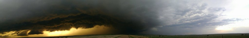
Panoramic of supercell storm (Photo courtesy of Grady Dixon)
Tornadoes:
|
|
||||||||||
|
||||||||||
|
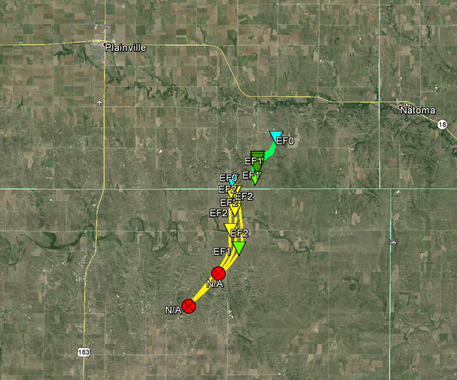
Tornado #1 - Catharine to Codell Tornado
|
||||||||||||||||
|
||||||||||||||||
|
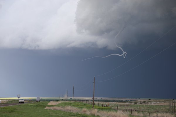
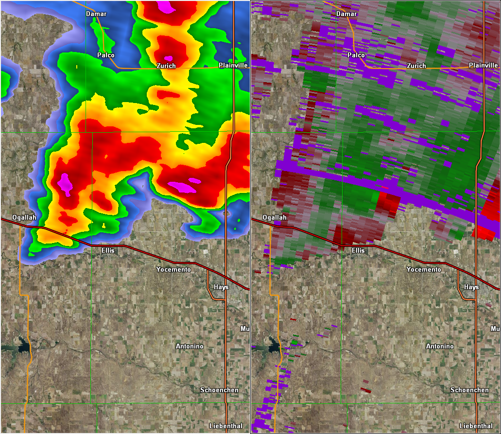
Tornado #2 Ellis
|
||||||||||||||||
|
||||||||||||||||
|
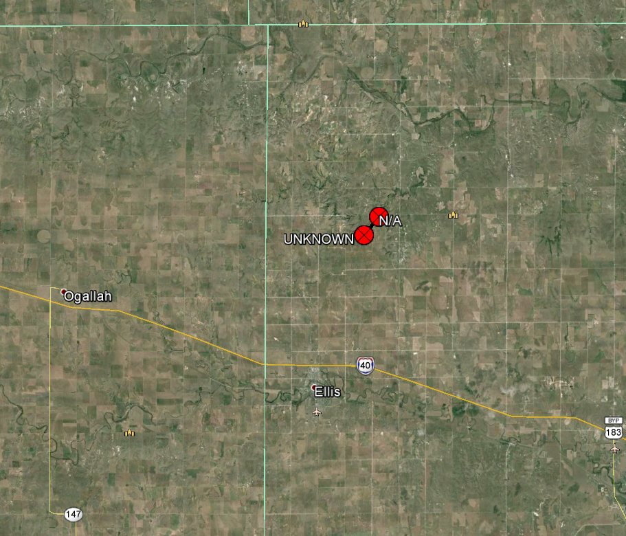
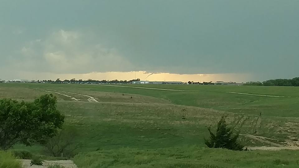
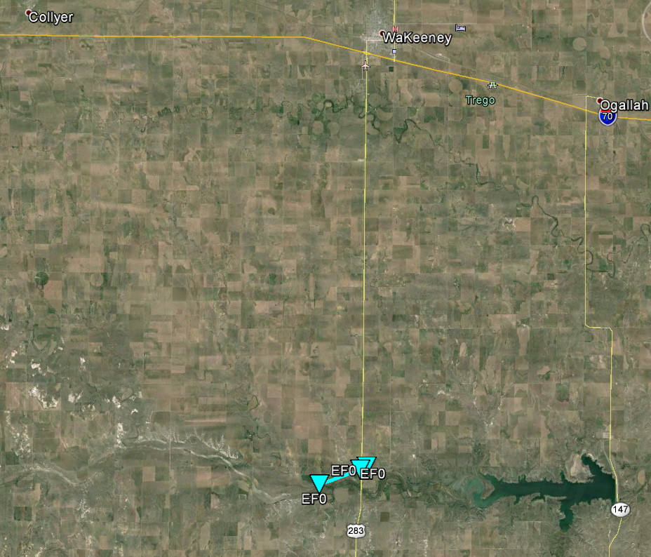
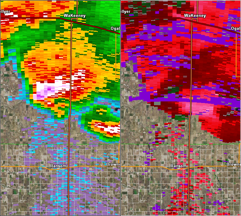
Tornado #3 Cedar Bluff
|
||||||||||||||||
|
||||||||||||||||
The Enhanced Fujita (EF) Scale classifies tornadoes into the following categories:
| EF0 Weak 65-85 mph |
EF1 Moderate 86-110 mph |
EF2 Significant 111-135 mph |
EF3 Severe 136-165 mph |
EF4 Extreme 166-200 mph |
EF5 Catastrophic 200+ mph |
 |
|||||
Radar:
Header
 |
 |
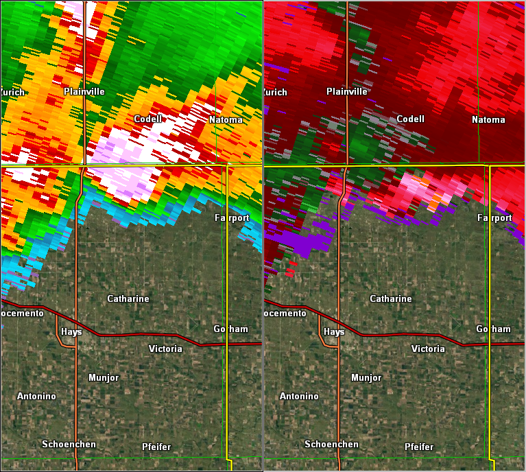 |
| Radar imagery from approximate time of tornado west of Cedar Bluffs Reservoir (~ 6 pm CDT). | Radar imagery from approximate time of tornado north of Ellis (~ 700 pm CDT). | Radar imagery from approximate time of tornado north of Hays (~ 720 pm CDT). |
Storm Reports
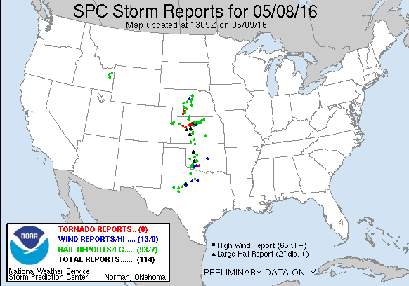
PRELIMINARY LOCAL STORM REPORT...SUMMARY
NATIONAL WEATHER SERVICE DODGE CITY KS
806 AM CDT MON MAY 9 2016
..TIME... ...EVENT... ...CITY LOCATION... ...LAT.LON...
..DATE... ....MAG.... ..COUNTY LOCATION..ST.. ...SOURCE....
..REMARKS..
0539 PM HAIL 5 ESE LAKE COLDWATER 37.21N 99.27W
05/08/2016 E1.75 INCH COMANCHE KS LAW ENFORCEMENT
0605 PM HAIL 7 N KINSLEY 38.02N 99.41W
05/08/2016 E3.00 INCH EDWARDS KS LAW ENFORCEMENT
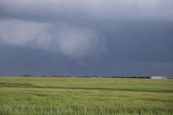
0607 PM TORNADO 6 SSW TREGO CENTER 38.81N 99.94W
05/08/2016 TREGO KS STORM CHASER
TORNADO LASTED ABOUT 5 MINUTES.
0635 PM HAIL 3 SSW ELLIS 38.90N 99.58W
05/08/2016 E2.75 INCH ELLIS KS LAW ENFORCEMENT
0638 PM HAIL DILLWYN 37.97N 98.87W
05/08/2016 E0.75 INCH STAFFORD KS LAW ENFORCEMENT
0643 PM HAIL 3 NW BISON 38.55N 99.24W
05/08/2016 M1.25 INCH RUSH KS TRAINED SPOTTER
0650 PM HAIL 2 N YOCEMENTO 38.94N 99.42W
05/08/2016 M1.75 INCH ELLIS KS STORM CHASER
0708 PM TORNADO 7 NW CATHERINE 39.00N 99.30W
05/08/2016 ELLIS KS LAW ENFORCEMENT
0713 PM TORNADO 9 NW EMMERAM 39.06N 99.24W
05/08/2016 ELLIS KS STORM CHASER
0714 PM HAIL 6 ESE LARNED 38.15N 99.00W
05/08/2016 E1.00 INCH PAWNEE KS PUBLIC
0715 PM TORNADO 9 NNW EMMERAM 39.09N 99.19W
05/08/2016 ELLIS KS PUBLIC
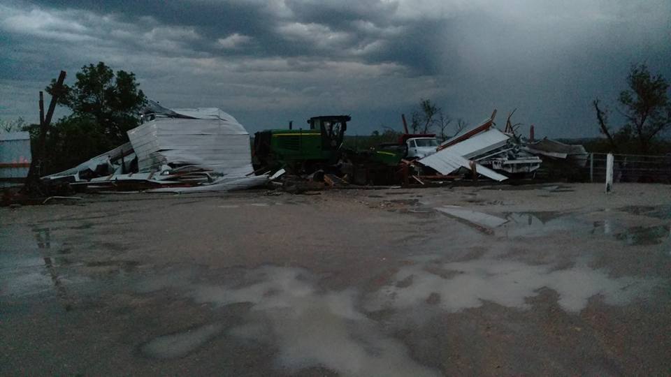
SIGNIFICANT DAMAGE TO FARM HOUSE AND
OUTBUILDINGS.
0718 PM TORNADO 7 NNW CATHERINE 39.02N 99.26W
05/08/2016 ELLIS KS PUBLIC
0720 PM TORNADO 7 NNE ELLIS 39.02N 99.50W
05/08/2016 ELLIS KS STORM CHASER
BRIEF TORNADO.
0820 PM HAIL 6 NE LAKE CITY 37.42N 98.75W
05/08/2016 E1.00 INCH BARBER KS PUBLIC
0911 PM HAIL 4 SSE RANSOM 38.58N 99.90W
05/08/2016 E1.00 INCH NESS KS PUBLIC
0913 PM HAIL 6 SSE RANSOM 38.55N 99.91W
05/08/2016 E1.75 INCH NESS KS TRAINED SPOTTER
0918 PM HAIL 6 SSE RANSOM 38.55N 99.91W
05/08/2016 E2.50 INCH NESS KS EMERGENCY MNGR
1010 PM HAIL SCHOENCHEN 38.71N 99.33W
05/08/2016 E1.00 INCH ELLIS KS TRAINED SPOTTER
1010 PM HAIL 4 S MUNJOR 38.75N 99.26W
05/08/2016 E3.00 INCH ELLIS KS COCORAHS
THE HAIL RESULTED IN SHREDDED LEAVES, CAR
DENTS AND DAMAGED SHINGLES.
 |
Media use of NWS Web News Stories is encouraged! Please acknowledge the NWS as the source of any news information accessed from this site. |
|