
Severe thunderstorms and flash flooding risks increase across the center of the nation today. Meanwhile, ongoing thunderstorms and flash flooding will linger along the Gulf Coast states through the evening. The Great Basin and Intermountain West, warm temperatures and dry fuels with dry lightning may enhance fire weather potential. In addition, across interior Alaska, Red Flag Warning are posted. Read More >
Extreme Winter Storm crippled much of Southwest Kansas to conclude 2006
*** Updated January 11th ***
Widespread total precipitation from this storm ranged from 2 to 4"+ over much of Southwest Kansas. There was even an area from Garden City to Dighton that had up to six inches of rain and freezing rain! This is incredible for anytime of the year, let alone for December. Significant, widespread damage to trees and especially utility lines, poles, and towers resulted from the 1/2" to 2 1/2" of ice accumulation. In an area from Sublette to Garden City, north through Dighton had the most severe damage. Over 60 thousand people were without electricity at one time or another from the nearly 10 thousand of power poles that were taken down from the weight of the ice. Some of these structures were high transmission towers. Click on the image for a larger view (image by forecaster Mike Umscheid).

Tree damage was extreme! It will take weeks to clean up just tree damage.
As of January 5th, there were still around 11,000 people without electric service and as of January 11th there were still approximately 4000 utility customers without power. Crews with heavy equipment cannot install power poles because of the deep mud on county roads. In addition, service from the poles to the home meters is not possible yet because of local damage on homes. Some people may be without electricity until the 4th week in January and home service to rural customers in that area may not be back on for the balance of January! Because of the loss of communication, the full extent of the damage may not be known for some time to come.
At the Dodge City airport, 3.21" of precipitation (rain, freezing rain and snow) fell from the storm. The only other time Dodge City, KS recorded over 3" of liquid equivalent precipitation in a single December storm was December 19-22, 1877 when 4.31" was measured. But there was even greater amounts! Up to six inches of rain and freezing rain fell in the Dighton area! The resulting ice was tremendous with several 300 foot communication towers toppled.
Here is the estimated storm total liquid-equivalent precipitation (in green) and storm total snowfall (blue overlay) for Southwest Kansas for December 28-31, 2006:

The following are some snowfall amounts for the storm.
Snow
Amount Location County
| 32.0 | Johnson 15 W | Stanton |
| 16.0 | Manter 6 NW | Stanton |
| 13.0 | Saunders | Stanton |
| 12.0 | Richfield 13 W | Morton |
| 12.0 | Coolidge 20 S | Hamilton |
| 10.0 | Richfield 13 NW | Morton |
| 10.0 | Johnson | Stanton |
| 8.0 | Syracuse | Hamilton |
| 8.0 | Collyer | Trego |
| 7.0 | Lakin | Kearny |
| 7.0 | Healy | Lane |
| 6.0 | Scott City | Scott |
| 5.0 | Shallow Water | Scott |
| 4.0 | Plymell | Finney |
| 4.0 | Utica 6 SW | Ness |
| 2.0 | Howell 4N | Ford |
The following is a summary of the equivalent precipitation that fell:
County Location Amount
| Lane | Dighton | 6" |
| Finney | Garden City 0.7 SE | 5.16" |
| Stanton | Johnson City 1.1 ENE | 4.72" |
| Gray | Ingalls 15 WSW | 4.67" |
| Grant | Ulysses 0.9 NW | 4.55" |
| Seward | Liberal 6.3 NW | 4.42" |
| Meade | Plains City 0.3 NW | 4.41" |
| ness | Arnold 4.8 NNW | 3.95" |
| Meade | Meade 0.4 NNW | 3.8" |
| Meade | MEADE 12 NW | 3.74" |
| Ford | Dodge City 2.5 NW | 3.7" |
| Gray | Ingalls 7.1 NNE | 3.69" |
| Meade | MEADE 10 N | 3.67" |
| Clark | Minneola 4.1 SSE | 3.63" |
| Hamilton | Syracuse 7.2 WSW | 3.52" |
| Ellis | Hays 11 SSW | 3.5" |
| Ford | Dodge City 1.7 SSW | 3.49" |
| Gray | CIMARRON 7 SE | 3.39" |
| Ford | Dodge City 2.2 N | 3.31" |
| Ness | Utica 5.9 SSW | 3.28" |
| Finney | Garden City 8.3 NNW | 3.27" |
| Hodgeman | Jetmore 6.9 ESE | 3.2" |
| Hamilton | Syracuse 10.6 N | 3.1" |
| Stevens | Moscow 6.4 S | 3.01" |
| Gray | Cimarron 0.5 N | 2.97" |
| Ellis | Hays 1.7 NW | 2.76" |
| Ellis | Ellis 11 NNE | 2.62" |
| Clark | Englewood 3.8 WNW | 2.52" |
| Clark | Ashland 14.6 SSE | 2.41" |
| Pratt | Pratt 2.6 S | 1.6" |
| Barber | Coats 6.6 WSW | 1.52" |
| Pratt | Preston 3.2 WNW | 1.5" |
| Comanche | Coldwater 6.7 NW | 1.47" |
| Barber | Medicine Lodge 0.4 WSW | 0.99" |
And, the following are some images of the winter landscape painted across western Kansas:

Weskan in west central KS - photo by Mike Umscheid

Buried truck and trailer near Sheridan Lake in far eastern Colorado - photo by Mike Umscheid

Dodge City National Weather Service Office - photo by Mike Umscheid

Snow removal in west central Kansas - photo by Mark Davis - Kansas Dept. of Transportation

Ice just NW of Dodge City - photo by Jeff Hutton

Photo by Jeff Hutton
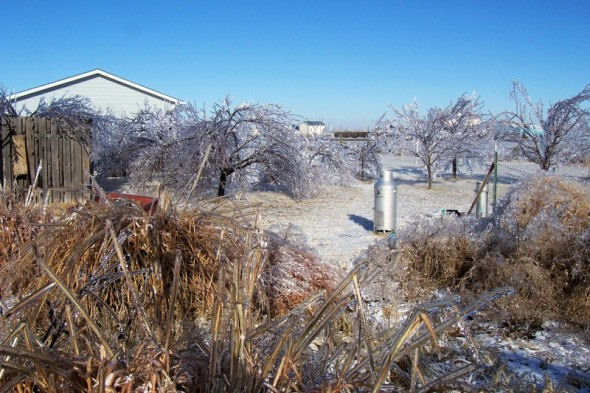
Photo by Jeff Hutton

Photo by Jeff Hutton

Photo by Jeff Hutton

Communications tower east of Dighton - Photo by Scott Reiter

Another communications tower just east of Dighton that collapsed from the ice - photo by Scott Reiter

