Overview
|
A supercell thunderstorm developed during the late afternoon on September 10th in northern Platte County, WY. The storm initially produced large hail up to baseball size near Glendo, WY. The storm rapidly intensified as it moved east, prompting a Tornado Warning at 3:08 PM. The Platte County Emergency Manager reported seeing the tornado 2 miles south of southeast of Hartville at 3:09 PM and crossed the Platte/Goshen County border around 3:15 PM. Around 3:19 PM, a storm chaser reported seeing a wedge shaped tornado 8 miles east-northeast of Guernsey. This supercell thunderstorm continued to produce tornadoes as it approached and moved east of Highway 85. The storm's mesocyclonic rotation remained strong over the course of 25 miles producing multiple tornadoes and large hail until around 4:45 PM when the final tornado reportedly dissipated. Three members of the National Weather Service Weather Forecast Office in Cheyenne along with officials from Goshen County investigated the damage north of Fort Laramie. Numerous ranches in the area suffered roof damage, tree damage, and barn collapses. Additionally, livestock and wildlife were lost in the storm. Based on the damage surveyed, the team estimated peak winds of 130 MPH classifying the tornado as an EF-2.
|
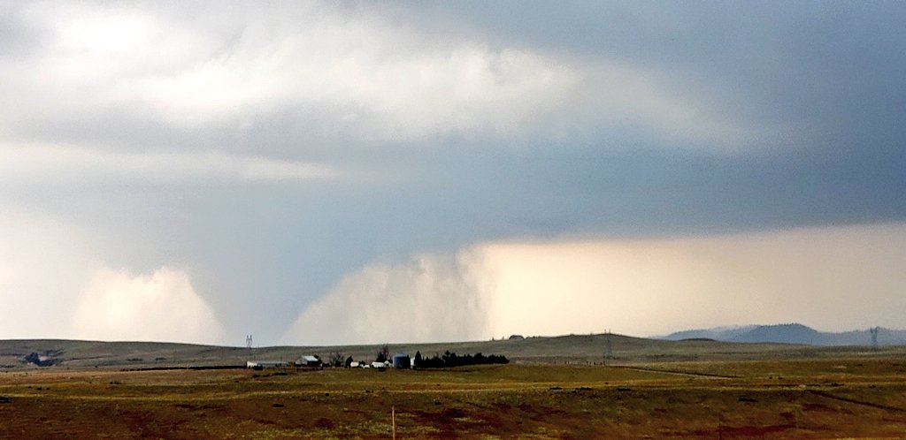
Tornado northeast of Guernsey. Credit: Dan Fitts |
 |
 |
 |
|
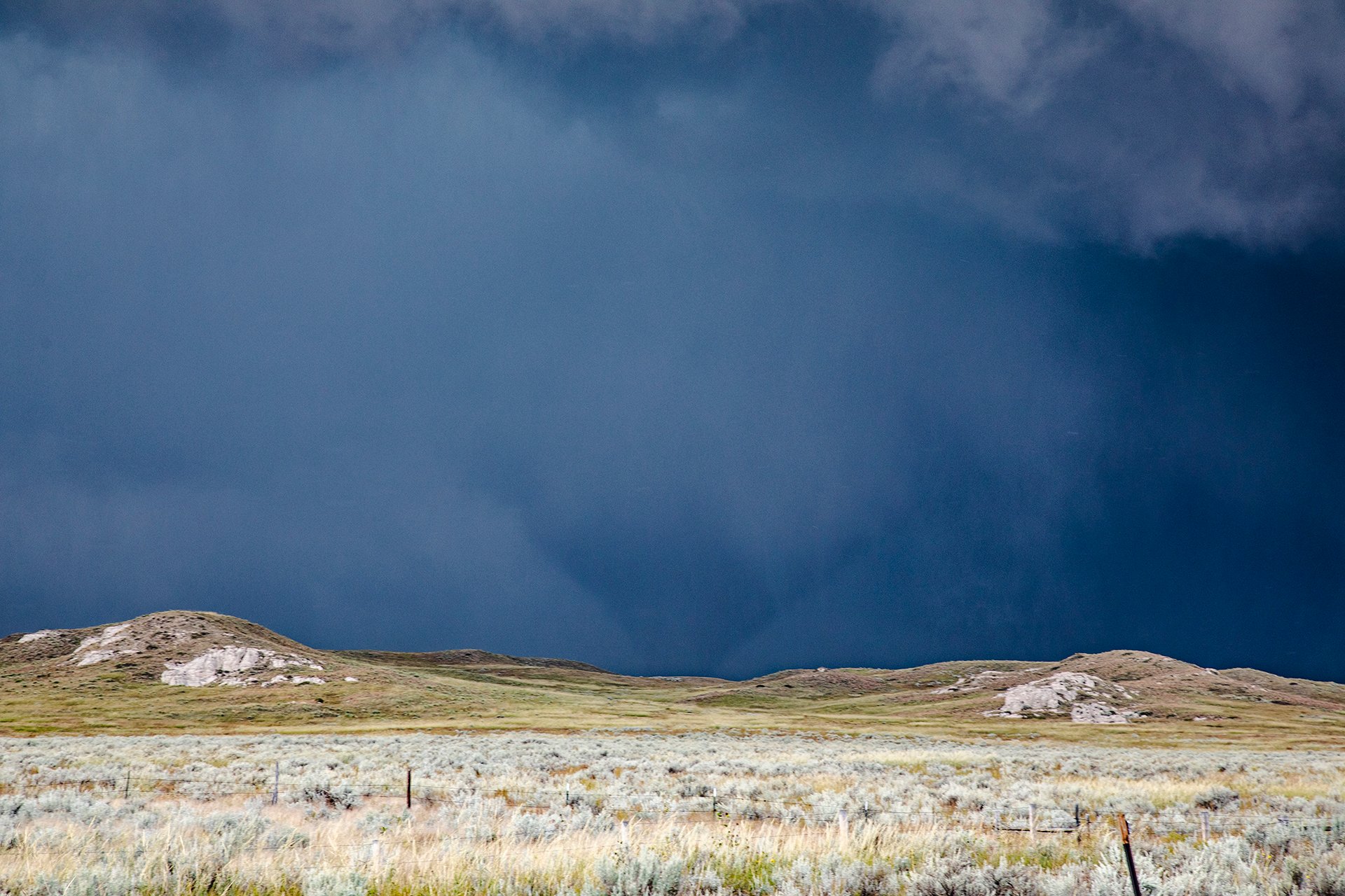
Tornado north of Lingle at 4:35 PM. Credit: Ryan Shepard |
Tornado north of Fort Laramie at 3:35 PM. Credit: Aaron Rigsby |
Hailstone around 4 inches in diameter 15 miles north of Lingle at 3:55 PM. Credit: Dan Fitts |
Tornadoes:
|
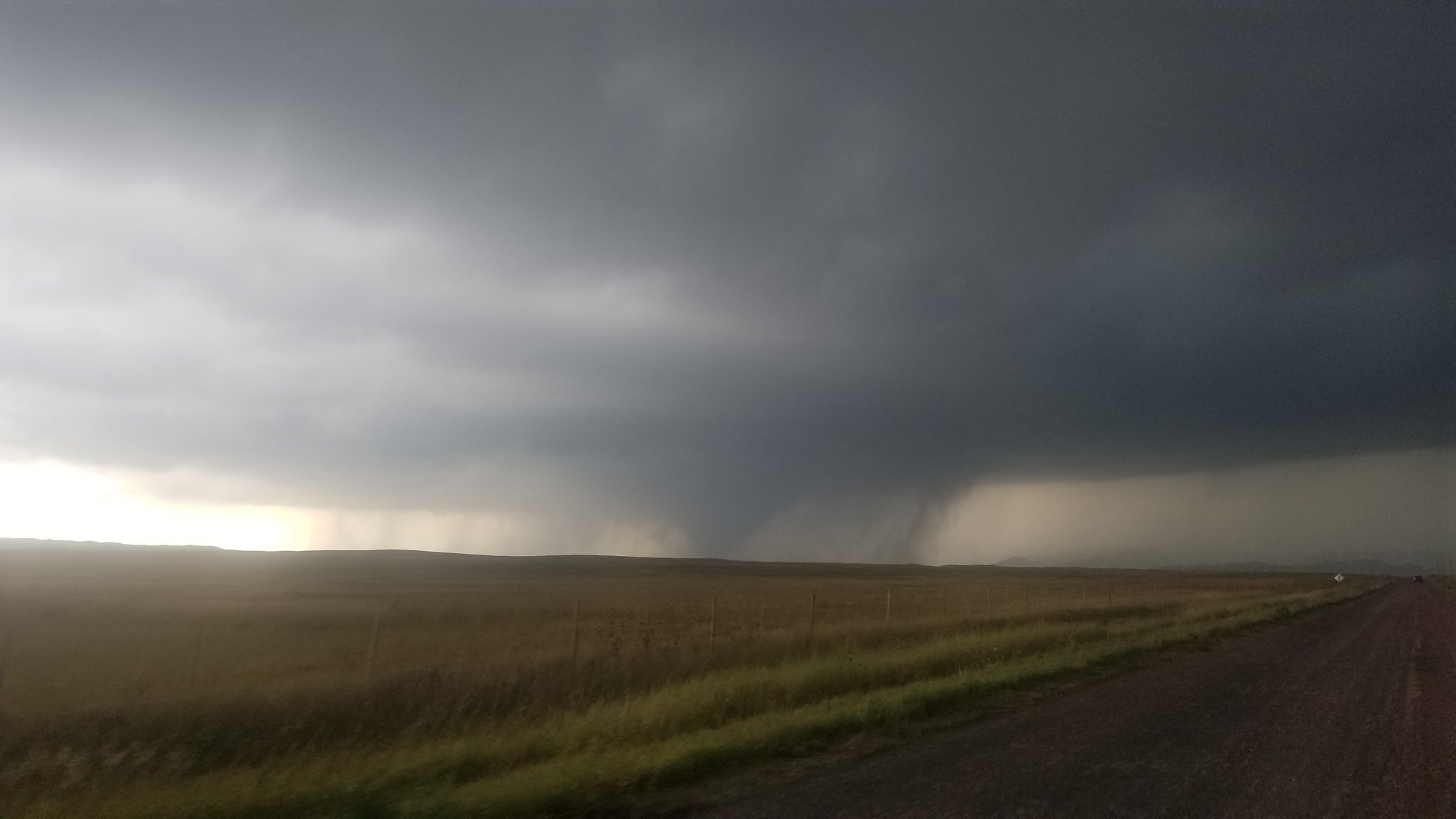
Tornado - north of Fort Laramie
Track Map
*Multiple tornadoes were reported on this path that covered 25 miles, but one single tornado did not travel the entire path. |
The Enhanced Fujita (EF) Scale classifies tornadoes into the following categories:
| EF0 Weak 65-85 mph |
EF1 Moderate 86-110 mph |
EF2 Significant 111-135 mph |
EF3 Severe 136-165 mph |
EF4 Extreme 166-200 mph |
EF5 Catastrophic 200+ mph |
 |
|||||
Public Information Statement National Weather Service Cheyenne, WY 558 PM MDT Wed Sep 11 2019 ...PUBLIC INFORMATION STATEMENT... ...NWS DAMAGE SURVEY FOR 09/10/2019 TORNADO EVENT NEARLY 10 MILES NORTH OF FT. LARAMIE WYOMING... A supercell thunderstorm developed during the late afternoon on September 10th in northern Platte county. The storm rapidly intensified as it moved east, prompting a Tornado Warning at 308 pm. The Emergency Manager at Platte county reported seeing the tornado 2 miles south of Hartville at 309 pm and crossed the Platte/Goshen county line around 315pm. Around 319 pm, a storm chaser reported seeing a wedge shaped tornado 8 miles east- northeast of Guernsey. Storm chaser videos also reported a multi-vortex tornado. However, the tornado path was discontinuous as it moved east through Goshen county during the next 2 hours and had periods where it cycled before dissipating. Our survey team along with officials from Goshen county investigated the tornado damage this afternoon north of Ft. Laramie. Here are the preliminary results of the survey. .5 to 10 miles of Ft. Laramie Wyoming... Rating: EF2 Estimated peak wind: 130 mph Path Length: Undetermined Path Width: Undetermined Fatalities: 0 Injuries: 0 Start date:9/10/2019 Start Time:3:26pm MDT Start Location:8-9 miles north of Ft. Laramie Start Lat/Lon: 42.3339, -104.5405 End date:9/10/2019 End Time: Undetermined End Location:Still Undetermined End Lat/Lon: Undetermined EF Scale: The Enhanced Fujita Scale Classifies Tornadoes into the following categories. EF-0...Weak......65 to 85 mph EF-1...Weak......86 to 110 mph EF-2...Strong....111 to 135 mph EF-3...Strong....136 to 165 mph EF-4...Violent...166 To 200 mph EF-5...Violent...>200 mph NOTE: The information in this statement is PRELIMINARY and subject to change pending final review of the event and publication in NWS Storm Data. |
Video:
Tornado
4:14 pm off of US-85 #WYWX @NWSCheyenne pic.twitter.com/zvnXaKMy60
— Brendon (@brendonme) September 10, 2019
Tornado #3 as it approached Hyway 85 N of Lingle,Wy @KNEBStormCenter @NWSCheyenne @severestudios #wywx pic.twitter.com/NPH8e3Qx7U
— Dan Fitts (@Dan_Fitts) September 11, 2019
Radar:
 |
 |
|
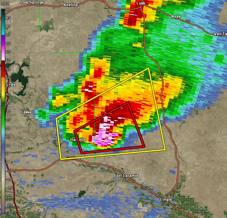
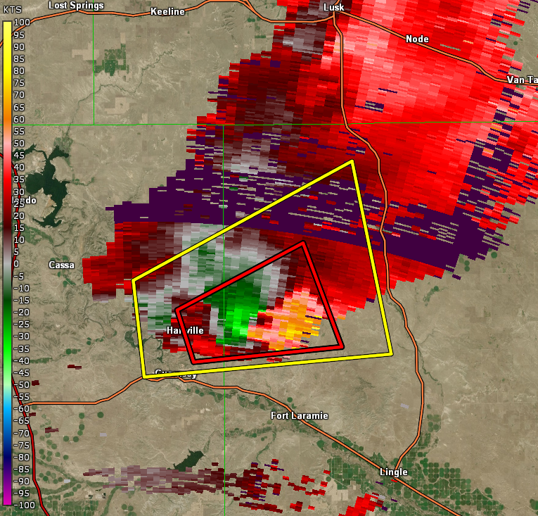
Radar reflectivity image at 3:19 PM minutes after the first reported tornado. |
Radar velocity image at 3:19 PM. The green-red couplet depicts the tornadic rotation. |
 |
 |
|
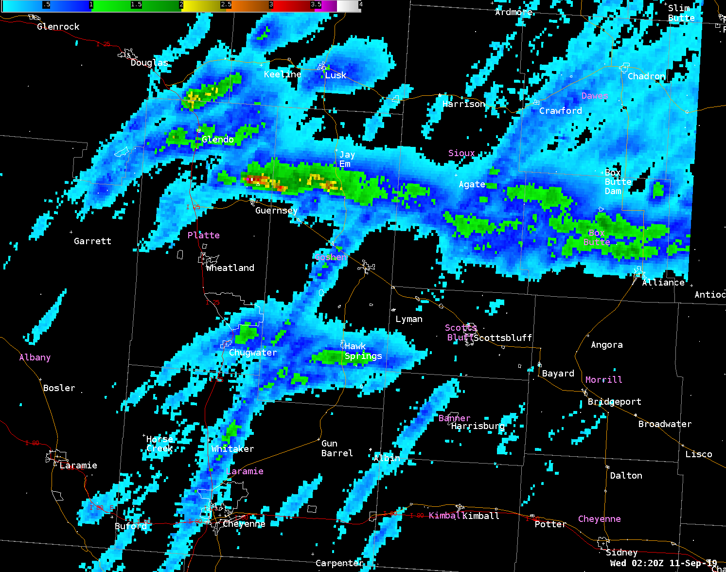
MRMS Low-Level Rotation Tracks showing the area of strongest rotation over northeastern Platte and northern Goshen Counties in Wyoming. |
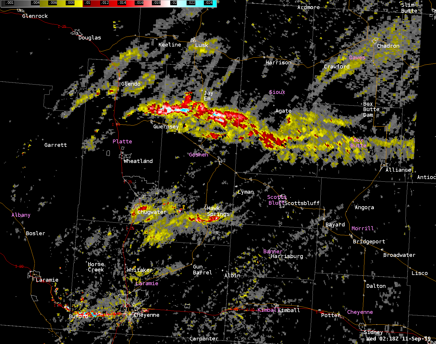
MRMS Maximum Estimated Size of Hail (MESH) Tracks from the tornadic supercell with hail size estimates of 2.5 to 4 inches near the Platte-Goshen County border. |
Storm Reports
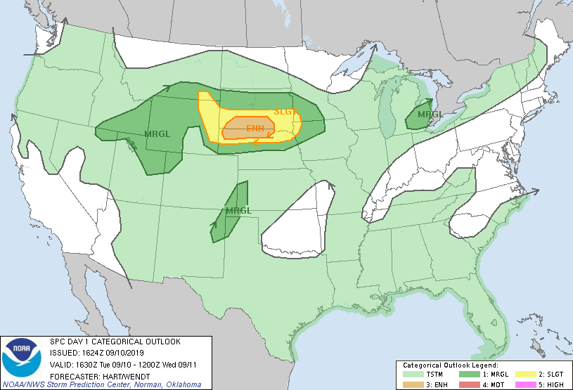
Storm Prediction Center Outlooks
 |
 |
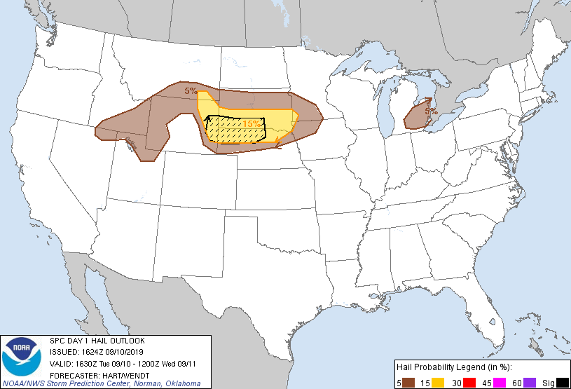 |
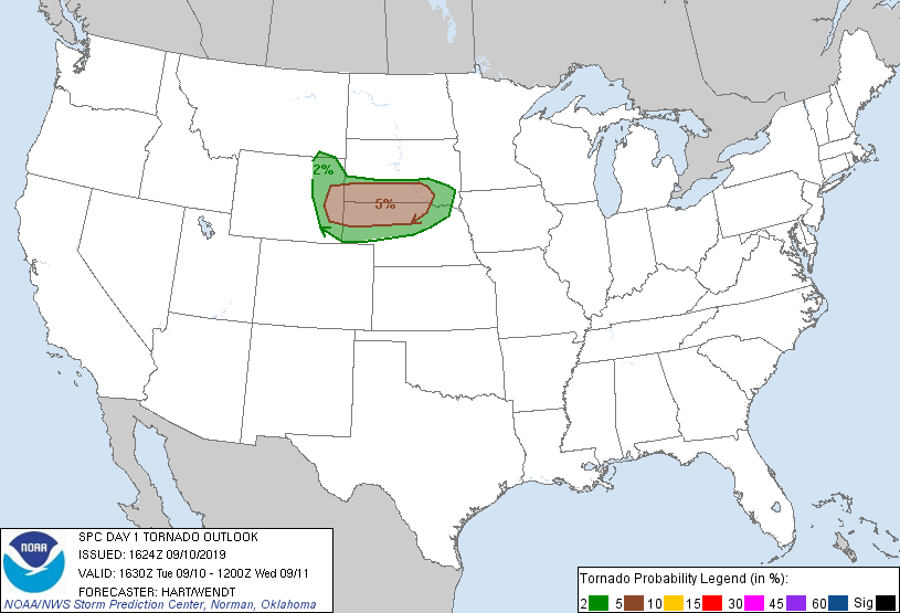
| SPC Day 1 Categorical Outlook | SPC Day 1 Tornado Outlook | SPC Day 1 Hail Outlook |
Storm Reports
|
|
|
||||||||||||||
| September 10, 2019 Storm Reports |
PRELIMINARY LOCAL STORM REPORT...SUMMARY
NATIONAL WEATHER SERVICE CHEYENNE WY
913 PM MDT TUE SEP 10 2019

..TIME...   ...EVENT...      ...CITY LOCATION...     ...LAT.LON...
..DATE...   ....MAG....      ..COUNTY LOCATION..ST.. ...SOURCE....
            ..REMARKS..

0210 PM     HAIL             GLENDO                  42.50N 105.03W
09/10/2019  E1.50 INCH       PLATTE             WY   TRAINED SPOTTER

            REPORTS IN GLENDO OF 1 TO 1 1/2 INCH DIAMETER HAIL.

0215 PM     HAIL             GLENDO                  42.50N 105.03W
09/10/2019  E2.75 INCH       PLATTE             WY   EMERGENCY MNGR

            HAIL UP TO BASEBALL SIZE IN GLENDO.

0305 PM     HAIL             2 S HARTVILLE           42.30N 104.72W
09/10/2019  E1.75 INCH       PLATTE             WY   PUBLIC

0309 PM     TORNADO          2 SE HARTVILLE          42.31N 104.70W
09/10/2019                   PLATTE             WY   EMERGENCY MNGR

0314 PM     HAIL             2 NE GUERNSEY           42.29N 104.72W
09/10/2019  M1.75 INCH       PLATTE             WY   PUBLIC

            GOLF BALL HAIL MEASURED OVER HAIL CORE AREA. THIS IS A
            CORRECTED LOCATION

0319 PM     TORNADO          8 ENE GUERNSEY          42.33N 104.61W
09/10/2019                   GOSHEN             WY   STORM CHASER

            WEDGE-SHAPED TORNADO.

0340 PM     HAIL             15 SW JAY EM            42.32N 104.57W
09/10/2019  E4.25 INCH       GOSHEN             WY   STORM CHASER

0355 PM     HAIL             15 N LINGLE             42.36N 104.35W
09/10/2019  M4.25 INCH       GOSHEN             WY   STORM CHASER

            MULTIPLE HAIL STONES BETWEEN 4 AND 4 3/8 INCHES MEASURED

0414 PM     TORNADO          14 N LINGLE             42.34N 104.35W
09/10/2019                   GOSHEN             WY   STORM CHASER

            TORNADO WEST OF HIGHWAY 85.

0419 PM     TORNADO          15 NNW LINGLE           42.34N 104.46W
09/10/2019                   GOSHEN             WY   STORM CHASER

            WEDGE TORNADO

0428 PM     HAIL             12 N LINGLE             42.31N 104.35W
09/10/2019  E2.50 INCH       GOSHEN             WY   EMERGENCY MNGR

            HAIL UP TO TENNIS BALL SIZE ON US HIGHWAY 85.

0435 PM     TORNADO          13 NNE LINGLE           42.31N 104.25W
09/10/2019                   GOSHEN             WY   STORM CHASER

            TORNADO NOW EAST OF HIGHWAY 85.

0446 PM     TORNADO          13 N TORRINGTON         42.26N 104.18W
09/10/2019                   GOSHEN             WY   TRAINED SPOTTER

0458 PM     TORNADO          5 E CHUGWATER           41.76N 104.72W
09/10/2019                   PLATTE             WY   PUBLIC

            ROPE TORNADO OBSERVED

0500 PM     TORNADO          2 E CHUGWATER           41.76N 104.78W
09/10/2019                   PLATTE             WY   EMERGENCY MNGR

0505 PM     TORNADO          15 W HAWK SPRINGS       41.79N 104.56W
09/10/2019                   GOSHEN             WY   EMERGENCY MNGR

            REPORT FROM SPOTTER RELAYED FROM YODEREM VIA WYOLINK.

0548 PM     HAIL             HAWK SPRINGS            41.79N 104.27W
09/10/2019  M1.00 INCH       GOSHEN             WY   EMERGENCY MNGR

            QUARTER SIZED HAIL REPORTED BY EMERGENCY MANAGEMENT WHILE
            MOBILE

0634 PM     HAIL             BEREA                   42.20N 102.99W
09/10/2019  E0.88 INCH       BOX BUTTE          NE   TRAINED SPOTTER

            NICKEL SIZED HAIL AND 0.80 INCHES OF RAIN REPORTED BY
            SPOTTER

0717 PM     HAIL             4 WNW BEREA             42.22N 103.07W
09/10/2019  M1.00 INCH       BOX BUTTE          NE   PUBLIC

            QUARTER SIZED HAIL OBSERVED BY PUBLIC. REPORTED VIA
            SOCIAL MEDIA
|
 |
Media use of NWS Web News Stories is encouraged! Please acknowledge the NWS as the source of any news information accessed from this site. |
|


 Weather Story
 Weather Map
 Local Radar