Overview
|
On July 16, 1979, the most destructive tornado in Wyoming's history occurred at Cheyenne. The main ingredient for the development of the Cheyenne F3 tornado was an outflow boundary from previous thunderstorms moving south across western Nebraska. In addition, abundant mid level moisture spread from the northeast and the presence of low level wind shear enhanced the risk for severe thunderstorms. The tornado was first reported at 3:10 PM by a weather service employee west of Cheyenne. The tornado began near the intersection of Vandehei Avenue and Valley View Road, and tracked to the east for approximately 9 miles. The majority of the damage was over residential areas of Buffalo Ridge and a nearby mobile home park. An estimated 200 homes were destroyed with 40 injuries and 1 fatality. An interactive and zoomable map is available on this 40th Anniversary Dashboard. Use the top half of the page to explore the areas hit by the tornado in 1979 and what infrastructure/roads would be impacted today. The bottom half of the page contains statistics of how many structures, people, and the median house value could be impacted if the tornado occurred today. |

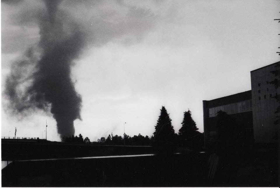
Tornado moving east near Buffalo Ridge Credit: Unknown |
https://noaa.maps.arcgis.com/apps/opsdashboard/index.html#/e6825ef89fd9443a9552c46aa036bf93
Tornadoes:
|
Tornado - Cheyenne, WY
Track Map

**Note: Map above is course and may not be accurate to street level |
The Enhanced Fujita (EF) Scale classifies tornadoes into the following categories:
| EF0 Weak 65-85 mph |
EF1 Moderate 86-110 mph |
EF2 Significant 111-135 mph |
EF3 Severe 136-165 mph |
EF4 Extreme 166-200 mph |
EF5 Catastrophic 200+ mph |
 |
|||||

Path of tornado across northern Cheyenne, WY. Dashed borders along paths indicate areas lacking tornadic surface winds. F1 damage track slightly wider. Numbers represent locations of persons and photographers. Locations of NWS employees affected were: 5 - Mcquate and 6 - Lauze. Times on margins are in GMT. |
Photos & Video:
 |
 |
 |
 |
|
Looking east from I-25 & Central Ave. Credit: Ken Collins & Jerry Geist Wyoming Highway Dept. |
Looking east from I-25 & Central Ave. Credit: Ken Collins & Jerry Geist Wyoming Highway Dept. |
Looking east from I-25 & Central Ave. Credit: Ken Collins & Jerry Geist Wyoming Highway Dept. |
Click for Youtube video of tornado. Photo taken near Cheyenne Airport. Credit: Unknown |
Radar and Personal Stories:
 |
|
Photo taken from "The Cheyenne Tornado of 16 July 1979". A storm assessment from William Parker and Richard Hickey, NWS Cheyenne, WY. Mine Genfile: "I worked in the basement of one of the buildings at WDOT. I was coming across the back parking lot toward our building and noticed the clouds were really close to the ground and were spinning. I reached up trying to touch them as I walked toward the boulding when a lady from our building called me to hurry and come look at the gnats that were spinning by our entry door. They looked like a miniture tornado. We both were surprised and went in to tell the men in the office. When I got to my desk I saw out the back window that two people were walking behind our building and the wind knocked them off their feet and a piece of the roof came off the tall building back there! Then the lights went out and we heard a loud sound and one of the older men commented it sounded like the tornadoes did when he was a kid and his folks would have them get in the potato cellar." Kathy Schenck: "Missed our house in Buffalo Ridge by three houses. We were huddled in the basement with our dog and cat listening to objects hitting our house. Our back yard had a boat in it and was full of hard word flooring from demolished houses after the storm. We also had a piece of wood embedded in the fascia about six inches. Close call indeed. " Sandy Scott: "I worked in the basement at WYDOT at the time. The power went out, so we made our way upstairs (no emergency lights in the basement then). We looked out the front door and saw the tornado approaching the newly constructed Governor's residence. Miraculously, it veered away across the golf course, then toward the National Guard at the airport. After toppling a C-130, it ultimately moved on to Buffalo Ridge where most of the damage occurred. We later learned that the tornado had traveled between WYDOT & the Game & Fish buildings, leaving cars overturned in those parking lots. We had no idea about the danger we had just encountered. That storm is the primary reason Cheyenne implemented an emergency warning system." |
 |
Media use of NWS Web News Stories is encouraged! Please acknowledge the NWS as the source of any news information accessed from this site. |
|


 Weather Story
 Weather Map
 Local Radar