Overview
|
A slow-moving, upper-level disturbance moved from the southwest U.S. into southern Colorado then Nebraska from 8 March through 15 March, 2021. This disturbance strengthened on the weekend of 13-15 March and drew abundant moisture from the Gulf of America which was transported to eastern Wyoming. The deep moisture combined with a strong east wind and instability wrapping around the north side of this disturbance resulted in a unique setup with strong lift occurring along and east of the Laramie Range. This resulted in anomalously high snowfall amounts from southern Johnson and Natrona counties near Casper Mountain, extending southeast along and east of the Laramie range, where this lift was maximized. Snowfall rates of 2 to 3 inches per hour occurred at times Saturday night, 13 March, and continued through midday Sunday, 14 March. Of note, 14 inches fell in a six hour time period from 6 AM MDT, Sunday, 14 March, to noon MDT at the Casper International Airport, and 10 inches of snow fell at NWS Cheyenne in a five hour period from 12am MST, Sunday, 14 March, to 6am MDT. Thundersnow was reported and observed several times across Laramie County during this time frame of the most intense snowfall rates. Snow to liquid water ratios were low on Saturday with values near 7 to 1 before midnight and increased to 12 to 1 after midnight into Sunday. This resulted in heavy, wet snow, followed by drier, more driftable snow. In addition, wind speeds increased to 45 to 55 mph and caused significant drifting. Due to the significant drifting, many area roads were closed for an extended period of time including Interstate 80 between Rawlins and Cheyenne and Interstate 25 between Casper and Cheyenne from Saturday night March 13th through Wednesday morning March 17th. |
Tractors and heavy equipment continue to plow the Interstate 80 Summit around the clock to clear the 5+ foot drifts along the roadway. Credit: Wyoming Department of Transportation |
 |
 |
|
Reports of snow plows getting stuck on Sunday as the heavy wet snow and 50 MPH winds creating snow drifts made snow removal efforts nearly impossible for at time. Credit: Wyoming Department of Transportation |
Heavy equipment being used to clear snow from the Interstate 80 Summit all day Monday & Tuesday after the storm. Credit: Wyoming Department of Transportation |
Cheyenne Snow Pictures
 |
 |
|
Parked cars buried in downtown Cheyenne. Credit: Michael Cummo |
Tractors assisting stuck vehicles out on the roadways the day after the storm. Credit: Michael Cummo |
 |
|
|
Views of drifts along Interstate 80 between Cheyenne and Laramie as crews continue to clear roadways. Credit: Wyoming Department of Transportation |
Webcam view along Interstate 80 east of Cheyenne after the storm passed (top) and crews continuing to clear Interstate routes in the area (bottom). Credit: Wyoming Department of Transportation |
|
|
|
Additional Impacts
 |
 |
|
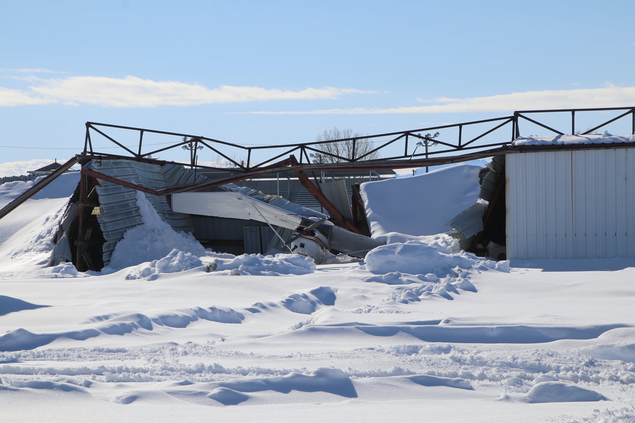
Numerous hangers collapsed due to heavy, wet snow at Phifer Airfield near Wheatland. Credit: Platte County Record-Times |
Cows trying to make a path through the deep snow. Credit: Unknown |
Radar and Satellite
 |
|
|
Regional radar reflectivity image around 1:00 PM MDT on March 14th as snowfall continued over much of the Front Range and Northern Plains. |
Local radar reflectivity image around 4:00 AM MDT on March 14th as heavy bands of snowfall with thundersnow approached Cheyenne. |
|
|
 |
|
GOES-16 Day Cloud Phase RGB imagery around 1:00 PM MDT March 14th. |
GOES-16 Water Vapor imagery around 10:30 AM MDT March 14th |
 |
|
GOES-16 Geocolor image showing the large spatial extent of this storm on the afternoon of March 14, 2021. |
NWS Cheyenne Operations
|
|
|
|
Meteorologist Matt Dewey analyzing ensemble snowfall forecasts (top) and Meteorologists Matthew Brothers and Chris Hammer discuss location of developing low along the Front Range (bottom). Credit: Jared Allen |
Warning Coordination Meteorologist Jared Allen discussing expected impacts from the blizzard during a live interview with WeatherNation. Credit: Angela Allen |
|
|
|
|
Meteorologists Ayesha Wilkinson and Jared Allen measuring snow meltdown to obtain liquid equivalent from snowfall. Credit: Matthew Brothers |
Meteorologist Matthew Brothers measuring snowfall in blizzard conditions (top) and picture of staff members who spend 5 straight days at the office during the blizzard and post-blizzard dig out. Credit: Chris Hammer (top) & Justin Ross (bottom) |
|
|
|
|
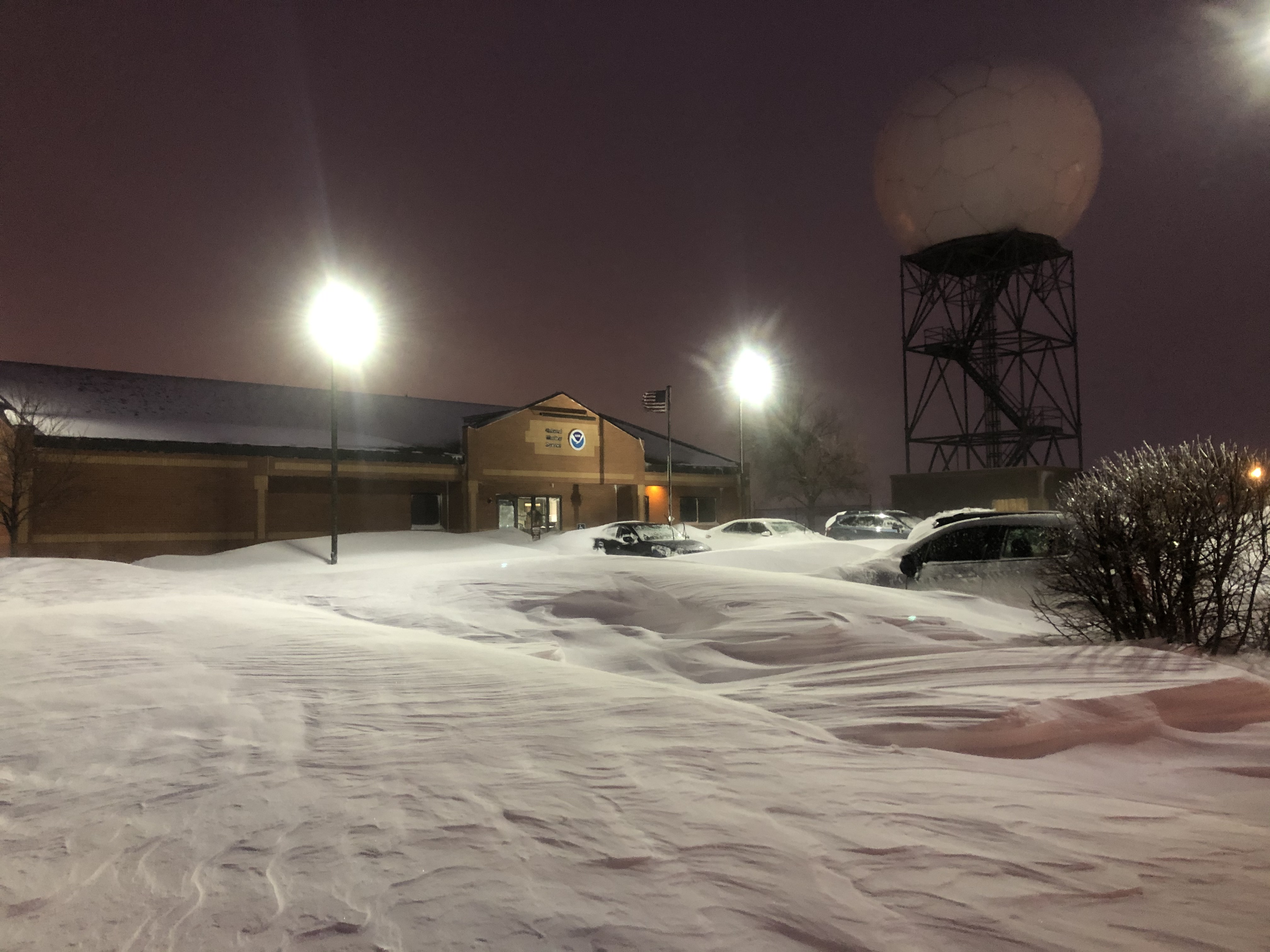
View of cars buried at NWS Cheyenne Parking lot. Credit: Chris Hammer |
Meteorologists Ayesha Wilkinson, Aviva Braun, and Lauren Kubelka braving the snow drifts near the office's parking lot. Credit: Chris Hammer |
|
|
|
Forecast and Storm Reports
NWS WFO Cheyenne Watches and Warnings
 |
 |
| Winter Storm Watch Issued as of Wednesday March 10th. | Blizzard Warnings Issued as of Saturday afternoon March 13th. |
NWS WFO Cheyenne Snowfall Forecasts Shared on Social Media
|
|
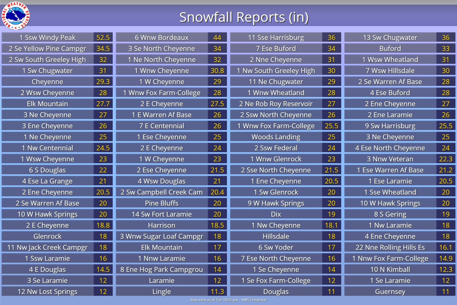
Snowfall and Blizzard Reports
|
|
|
 |
 |
Media use of NWS Web News Stories is encouraged! Please acknowledge the NWS as the source of any news information accessed from this site. |
|


 Weather Story
 Weather Map
 Local Radar