Overview
|
A powerful winter storm impacted a large part of southeast Wyoming and the western Nebraska Panhandle on February 22-24, 2017. The storm originated over eastern Siberia February 15, and intensified as it tracked across the Gulf of Alaska. The numerical models available to forecasters at the time were in remarkable agreement showing this storm impacting parts of the Central Rockies the following week, but failed to lock on to a solution with the track of the storm which would play a key role in the significance of the storm of the local area. This is not uncommon, as limited data over the Pacific Ocean does not allow storms to be adequately sampled until they come ashore. This system moved into the Northwest U.S. February 21, and tracked southeast across Wyoming and Colorado February 22-23 along with the passage of an arctic cold front. This storm continued to pose challenges to forecasters, even 12-24 hours prior to the onset of snow. The track of the low pressure system was still uncertain due to a strong high pressure ridge to the northeast, and environmental conditions were favorable for enhanced precipitation rates due to instability comparable to spring time thunderstorms. The exact location of this area of instability would determine areas which would see the heaviest snow. There were also concerns with dry air wrapping into the system and limiting precipitation amounts along the Interstate 80 corridor. Finally, it was obvious to forecasters that snow amounts would be lower in Laramie, Wyoming, due to easterly downslope winds causing drying on the west side of the Laramie Range, but it was not clear to what extent as models were still showing snowfall amounts in excess of 8 inches. Days preceding the storm were warm and dry, characterized by temperatures in the 60s and lower 70s. As the cold front passed, high temperatures at Alliance, Nebraska, fell from 73 degrees on February 21 to 34 degrees February 23. The snow began for areas west of the Laramie Range on the afternoon of February 22, and spread east of Interstate 25 early in the morning on February 23. Snowfall rates in excess of 2 inches per hour were observed before diminishing in the evening and overnight February 24. A broad swath of 12+ inches of snow was reported, including a 20-mile wide band of 20 to 25 inches extending from near Wheatland, Wyoming, east through Torrington, Wyoming, and Alliance, Nebraska. The dry air shown by the numerical models caused a sharp cutoff in snow amounts to the south, with only 2 to 5 inches along the Interstate 80 corridor from east of Cheyenne, Wyoming, to Sidney, Nebraska. One to three inches of snow fell in and around Laramie. In addition to the snow, gusty northerly winds resulted in considerable blowing and drifting snow, especially across western Carbon County, Wyoming, with blizzard conditions around Muddy Gap. This storm resulted in major impacts to transportation, resulting in numerous road closures across a large part of the region. |
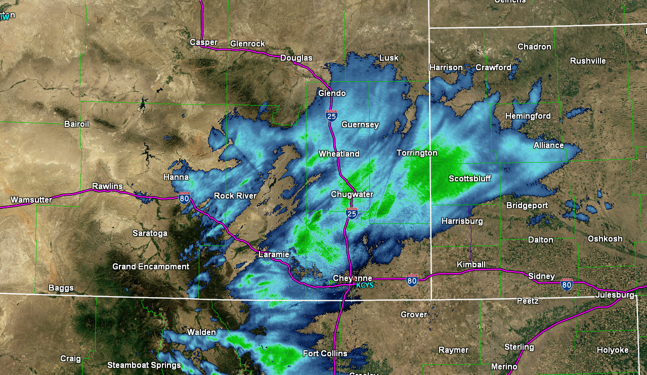
Radar loop from Feb. 22 at 7:00 PM to Feb. 23rd at 1:00 PM, showing snow sitting over southeast Wyoming and western Nebraska. |
 |
 |
|
The preliminary timeline for the winter storm from the National Weather Service in Cheyenne
|
February 23, National Weather Service Weather Story Graphic |
Snow Reports:
 |
 |
Photos & Video:
 |
 |
 |
|
Snowfall in Rolling Hills, WY Credit: Amy Potter |
Snowfall measurement in Lingle, WY Credit: Cory Gilchriest |
Snowfall in Torrington, WY Credit: Eddie Juve |
 |
 |
 |
|
Snowfall in Douglas, WY Credit: Roseanne Vasquez |
Snowfall in Glendo, WY Credit: Travis Gruwell |
Snowfall in Goshen County, WY Credit: Unknown |


 Weather Story
 Weather Map
 Local Radar