Cheyenne, WY
Weather Forecast Office
Overview
The F4 tornado on June 27, 1955 followed torrential rains on June 26 across the Nebraska Panhandle. High temperatures reached about 80 degrees and cumulus clouds began to develop by early afternoon. The situation of this particular day was a rare event that produced the largest and most devastating tornado in western Nebraska. The tornado began along the path from Henry, Nebraska along the Wyoming-Nebraska border, southeast along the North Platte River to about 8 miles east of Scottsbluff, Nebraska. This path was approximately 40 miles when the tornado dissipated.
Track Map:
 |
 |
|
||||||||||
|
Echo from the Weather Bureau radar in Scottsbluff at 3:55 PM. |
Click on the image for a video of the tornado moving through Scottsbluff. |
Enhanced Fujita (EF) Scale classifies tornadoes into the following categories:
| EF0 Weak 65-85 mph |
EF1 Moderate 86-110 mph |
EF2 Significant 111-135 mph |
EF3 Severe 136-165 mph |
EF4 Extreme 166-200 mph |
EF5 Catastrophic 200+ mph |
 |
|||||
Photos & Video:
 |
 |
 |
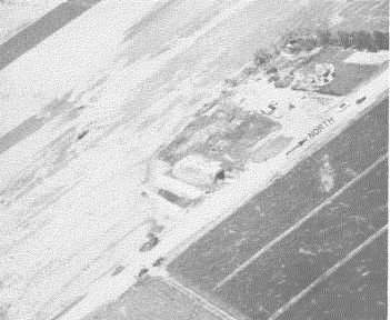
| Tornado as seen from the Weather Bureau office in Scottsbluff. | Tornado as seen from the Weather Bureau office in Scottsbluff, beginning to weaken. | Aerial photo of cultivated field near Scottsbluff showing swirl marks of the tornado's path |
US Dept of Commerce
National Oceanic and Atmospheric Administration
National Weather Service
Cheyenne, WY
1301 Airport Parkway
Cheyenne, WY 82001-1549
307-772-2468
Comments? Questions? Please Contact Us.


 Weather Story
 Weather Map
 Local Radar