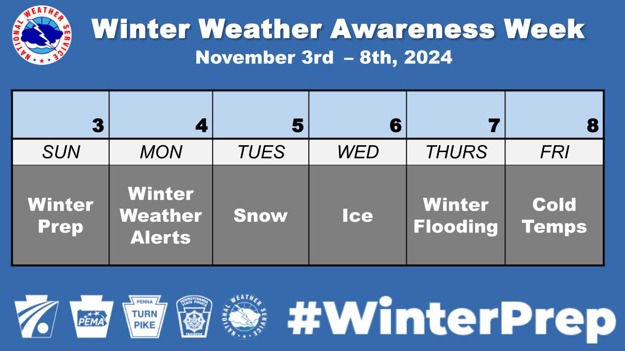
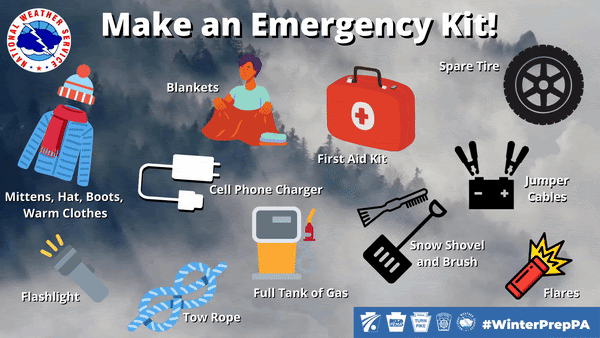
| The week of November 3rd through 8th is Winter Weather Awareness Week in Pennsylvania. |
|
|
|
| Sunday | Monday | Tuesday | Wednesday | Thursday | Friday |
|
|
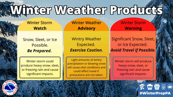
WINTER WEATHER ALERTS
Here are some terms which the national weather service uses to describe winter weather as well as the definitions of watches, warnings and advisories issued for winter weather events. A hazardous weather outlook is issued prior to a winter storm watch. In general a winter storm watch alerts the public to the possibility of heavy snow, heavy freezing rain, or heavy sleet. Winter storm watches are usually issued 24 to 48 hours before the beginning of a winter storm. These events may occur separately or in combination. Since watches are issued well in advance of the storm, there will be times when the storm does not materialize, so they may be canceled. On the other hand, a warning is issued when hazardous winter weather is imminent or has already begun. It is issued for conditions which pose a threat to life and property. The following are the warning headlines issued for winter weather events:
An advisory is issued for less serious weather conditions. Specific advisories will alert you to weather that would have a significant effect on motorists, outdoor activities, or public events. The following are the advisory headlines issued for winter weather events:
If you need timely information, you can get it on NOAA Weather Radio All Hazards. We broadcast twenty four hours a day across all of Pennsylvania. Weather radio monitors are inexpensive and guarantee you the latest weather whenever you have the need. Our broadcasts will help you plan for outdoor activities, get travel information, make business decisions, or decide on the proper clothing to wear. Most importantly, you will be ready when a winter storm strikes. We issue frequent updates during active winter weather, that serve to give you the most up to the minute, and detailed weather information available. In addition, we issue statements that follow up on the issuance of watches, warnings, or advisories.
|
SNOWSNOW SQUALLSThis year is the third year where we will be issuing Snow Squall Warnings throughout the winter. Please take a minute to learn more about snow squalls and how dangerous they are. For more, visit: weather.gov/safety/winter-snow-squall
When a snow squall hits, visibility can drop to almost nothing in an instant. There is no safe place on a highway during a snow squall, but if you do get stuck on the road:
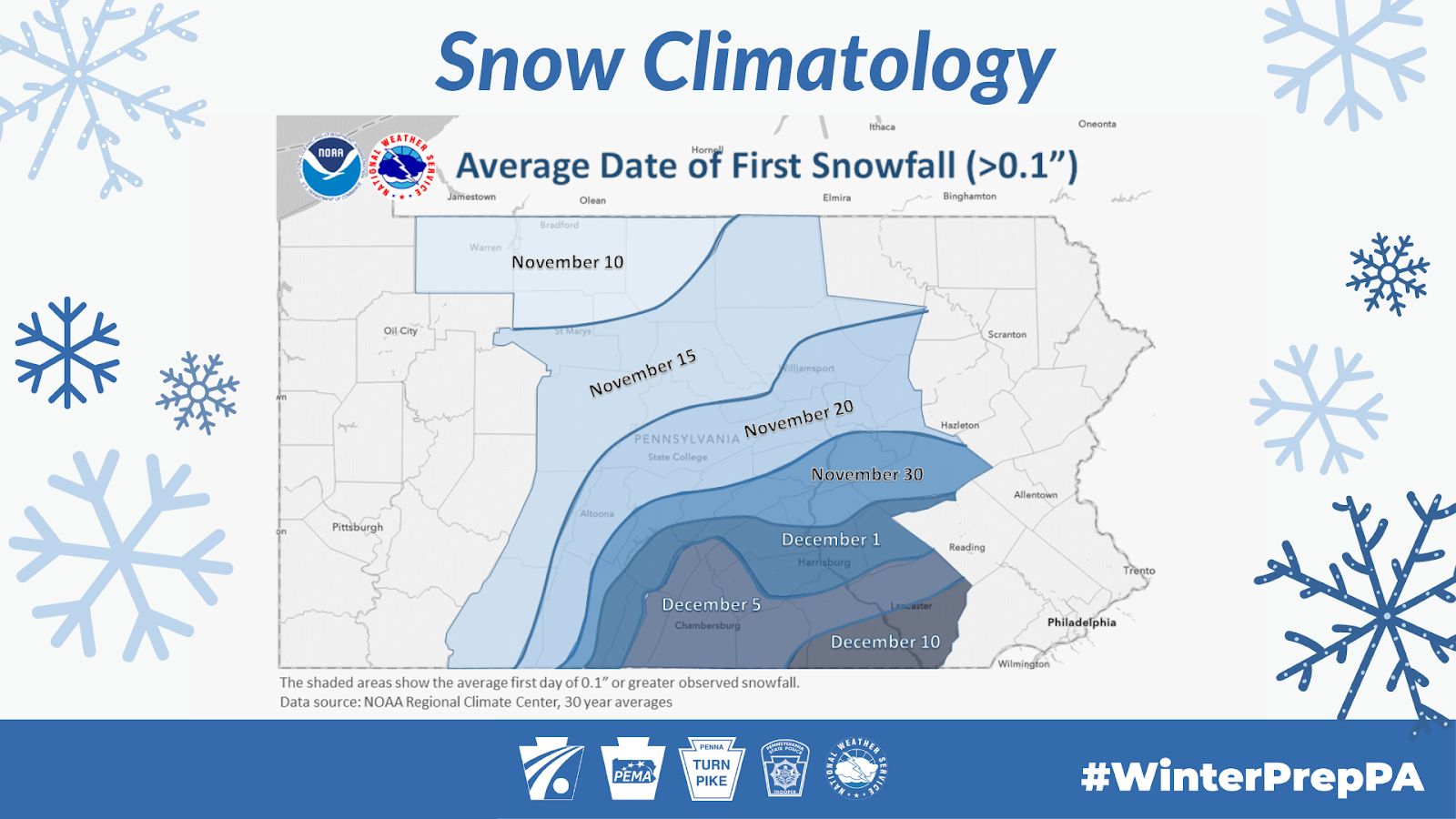
SNOW CLIMATOLOGY
On average, central PA sees the first snow in late November - we’ll see how this year pans out!
TYPES OF HEAVY SNOW EVENTS THAT IMPACT PENNSYLVANIA
https://www.weather.gov/ctp/SnowStormTypes Heavy snow can immobilize a region and paralyze a city, stranding commuters, closing airports, stopping the flow of supplies, and disrupting emergency and medical services. Accumulations of snow can cause roofs to collapse and knock down trees and power lines. Homes and farms may be isolated for days and unprotected livestock may be Heavy snow can be produced by Nor'easters, blizzards and overrunning situations. Lesser amounts of snow are often produced by Alberta Clippers.
Some snow terms which are commonly used include blizzard, blowing snow, snow squalls, snow showers and snow flurries.
|
ICE
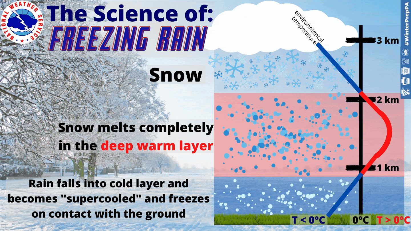
Winter weather forecasting is complex. As we make forecasts throughout the winter, we pay especially close attention to the “warm layer”. It determines whether you’ll see snow, sleet, freezing rain, or rain at your location.
Heavy accumulations of ice can bring down trees and power lines, as well as topple utility poles and communication towers. Ice can disrupt communications and power for days while utility companies repair extensive damage. Even small accumulations of ice can be Freezing rain is the result of precipitation which initially falls as snow, then encounters a layer of warm air which melts the snow changing it to rain. The rain then freezes as it encounters below freezing air at or near the surface creating a film of ice.
Most of the United States receives less than 10 hours of freezing rain annually with the highest frequency in the Saint Lawrence River valley where over 40 hours of freezing rain are observed annually. The National Weather Service issues ice storm warnings for Pennsylvania when significant ice accumulations are expected and winter weather advisories for any ice accretion which also includes freezing drizzle. The Poconos in northeast Pennsylvania are most susceptible to ice storms with the most recent storms occurring in January 2003 and 2005. 511 PA
While ice storms are most common in NE PA, black ice can occur anywhere. Monitor road conditions in real time at https://www.511pa.com
|
WINTER FLOODING
Flooding isn’t just a risk with thunderstorms and rain showers. Melting snow and ice jams increase danger. One of our deadliest winter weather hazards is flooding.
In Pennsylvania one usually associates snow, ice, and biting cold with winter. But sometimes nature throws a curve at us with unseasonable warmth, and with it, rain. A number of different factors work together to produce floods in winter. When unseasonable warmth comes to the region it will often melt much, if not all of the snow on the ground in the lower elevations. The melting snow will saturate the ground and also begin to swell the rivers. Often the warmer air will rise over colder air trapped in the region. As this air rises it results in clouds and rain, which will combine with the melting snow to increase flows in the rivers. When this melting snow combines with heavy rains it can put enough water into the rivers to send them over their banks. Some of our worst winter floods are caused by intense cyclones that track from the Ohio valley northeast up the Saint Lawrence Valley into Canada. These storms bring a lot of warm and moist air into the region from the Gulf of America and the Atlantic, bringing both mild temperatures and heavy rain to the region. In January 1996, unseasonably warm air and heavy rain combined to melt a deep snowpack in Pennsylvania. The combination of melting snow and heavy rain led to the worst flooding in Pennsylvania since hurricane Agnes in 1972. Another winter problem is flooding caused by ice jams on the rivers. As river flows increase, water levels rise. Since ice that covers the rivers is lighter than water it will tend to float. Under the pressure it will often break into huge slabs. These slabs will then move downstream in the current until they run into an obstruction such as a bend, island, or wide shallow area. When this happens the ice will often stop and pile up into a jam. When the flow of the river is blocked by an ice jam, the water can overflow the river banks in less than an hour as it tries to get around the ice. As the water rises, the pressure can break the jam and release a sudden surge of water and ice down the river. While ice jams often form in the same spots year after year it is nearly impossible to predict exactly when or where a jam will form, or when one will break. Sometimes a jam that forms in early winter will stay put most of the winter. Severe flooding of roads and built up areas can also occur when mounds of plowed snow and ice block and plug up the grates and storm drains, so the water from the pavement has nowhere to go. This standing water can cause dangerous black ice if it freezes. HOW YOU CAN HELP
Precipitation type forecasting is one of the most difficult parts of winter weather. That's why we need your help! Let us know if you're getting snow, sleet, rain, freezing rain, or a mix at your location all winter long through the mPING app!
|
COLD WEATHER
Cold weather’s effects can be very dangerous! When it is windy, air speeds up heat loss on our skin by whisking away the warmth. As a result, it feels colder than the actual air temperature!
FROSTBITE AND HYPOTHERMIA
Very cold weather can be a health hazard. However by dressing properly, you can safely spend time outdoors enjoying what the area has to offer in the form of winter recreation, whether it be skiing, snowmobiling, ice skating, or just taking in the winter scenery. Very cold temperatures can rob your body of life sustaining warmth, especially when combined with a strong wind. The combination of cold temperatures and wind is known as the wind chill. The wind chill is based on the rate of heat loss from exposed skin. As the wind speed increases, the rate of heat loss from your body also increases. A temperature of 20 degrees above zero with a wind can feel like a bitter cold 6 degrees when the wind blows at 15 miles an hour. Frostbite can occur when your fingers, cheeks, ears, toes, or even the tip of your nose is exposed to sub-freezing temperatures for a prolonged period of time. If any portion of your body becomes numb due to the cold, go indoors immediately and slowly warm the affected area to avoid tissue or nerve damage. Hypothermia is potentially even more dangerous. This health hazard is defined as the lowering of the body temperature below 95 degrees. Warning signs of hypothermia include uncontrollable shivering, memory loss, slurred speech, and disorientation. If not treated immediately by keeping the person warm and seeking medical help, hypothermia can be fatal. Hypothermia can affect anyone, but the elderly are the most susceptible. Over half the fatalities due to exposure from the cold occur to people over 60 years of age. Young children are also susceptible. Be sure to dress properly for the cold. Always wear several layers of warm, loose fitting clothing. These layers help to retain your body heat better than one heavy layer, and they can be removed to avoid perspiration and subsequent chill. The outer layer of clothes should also be water repellent. Don't forget to wear a hat since a significant loss of body heat occurs through your head. Also, mittens are better than gloves at protecting your fingers from the extreme cold.
|


 Send Us a Report