State College, PA
Weather Forecast Office
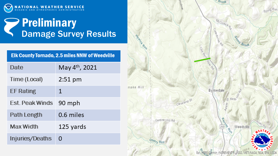
A tornado is confirmed to have touched down in Elk County on Tuesday May 4th just before 3 pm north-northwest of Weedville. Photo evidence shows tree damage concentrated along a narrow area along Old Byrnedale Rd and Route 255. Several trees were uprooted or snapped. This is likely near the end of the damage path based on weakening low level rotation and updraft strength observed by radar.
Video evidence from Weedville shows a rapidly rotating funnel approximately 0.5 miles west-southwest of route 255. A ridge line obstructed the view of the ground beneath the funnel. However, a radar-indicated tornado debris signature supports the idea that the tornado was likely on the ground and lofting debris at the time. That tornado debris signature can be seen below by the low Correlation Coefficient values co-located with the velocity signature on radar.
.png)
The path start and end points, path width and tornado strength are preliminary estimates and will be adjusted as necessary if new evidence of damage is found.
US Dept of Commerce
National Oceanic and Atmospheric Administration
National Weather Service
State College, PA
328 Innovation Blvd, Suite 330
State College, PA 16803
(814)954-6440
Comments? Questions? Please Contact Us.


 Send Us a Report