Tornadoes | Personal Stories | Meteorology | References & Links
Overview
On the evening of May 31st, 1985, a devastating and deadly tornado outbreak struck the Northeastern United States and Canada. 43 tornadoes and numerous damaging thunderstorms tore across Ohio, Pennsylvania, New York, and Ontario. This event was the deadliest tornado outbreak of the 1980's; killing 89 people in total, injuring more than 1,000 others, and racking up more than $600 million in property damage. In fact, since May 31, 1985, only two tornado days have been deadlier in the entire United States.
The storms were the result of high levels of atmospheric instability present in an environment favorable for tornadic thunderstorms, triggered by the passage of a strong late-spring cold front. Quoting the original survey report produced by NOAA in 1985, “perhaps the lesson to be learned from the 1985 outbreak is that under the proper atmospheric conditions, major tornadoes can occur irrespective of the location or terrain”.
This page will focus on the tornadoes that impacted northeastern Ohio, far southwestern New York, and Pennsylvania.
BULLETIN--IMMEDIATE BROADCAST REQUESTED
TORNADO WATCH NUMBER 211
4:25 PM EDT FRI MAY 31 1985
A…THE NATIONAL SEVERE STORMS FORECAST CENTER HAS ISSUED A TORNADO WATCH FOR
PORTIONS OF EASTERN OHIO
PORTIONS OF THE NORTHERN PANHANDLE. W. VA
PORTIONS OF WESTERN PENNSYLVANIA
PARTS OF SOUTHWEST NEW YORK
PORTIONS OF CENTRAL AND EASTERN LAKE ERIE
SOUTHERN LAKE ONTARIO
FROM 500 PM EDT UNTIL 1100 PM THIS FRIDAY AFTERNOON AND EVENING
B…TORNADOES…LARGE HAIL…DANGEROUS LIGHTNING AND DAMAGING THUNDERSTORM WINDS ARE POSSIBLE IN THESE AREAS. THE TORNADO WATCH IS ALONG AND 70 STATUTE MILES SOUTHWEST OF AKRON OHIO TO 20 MILES SOUTH OF ROCHESTER NEW YORK.
REMEMBER…A TORNADO WATCH MEANS CONDITIONS ARE FAVORABLE FOR TORNADOES AND SEVERE THUNDERSTORMS IN AND CLOSE TO THE WATCH AREA.
PERSONS IN THESE AREAS SHOULD BE ON THE LOOKOUT FOR THREATENING WEATHER CONDITIONS AND LISTEN FOR LATER STATEMENTS AND POSSIBLE WARNINGS.
…WEISS
Click on a tornado name in the table below to view more details about each tornado.
| Tornado | F-Rating |
Time |
Path Length (miles) | Path Width (yards) | Number of Injuries | Number of Fatalities |
|---|---|---|---|---|---|---|
| Albion, PA | 4 | 4:59 - 5:17 | 14 | 400 | 82 | 12 |
| Mesopotamia, OH | 3 | 5:05 - 5:20 | 15 | 440 | 30 | 0 |
| Linesville, PA | 2 | 5:10 - 5:15 | 4 | 200 | 0 | 1 |
| Atlantic, PA | 4 | 5:17 - 6:30 | 56 | 350 | 125 | 16 |
| Saegertown, PA | 3 | 5:23 - 5:55 | 23 | 277 | 0 | 0 |
| Corry, PA | 4 | 5:25 - 5:55 | 28 | 440 | 12 | 0 |
| Dorset, OH | 2 | 5:28 - 5:41 | 10 | 220 | 15 | 0 |
| Centerville, PA | 3 | 6:12 - 6:23 | 8 | 427 | 10 | 2 |
| Busti, NY | 3 | 6:25 - 6:45 | 13 | 177 | 10 | 0 |
| Thompson Run, PA | 1 | 6:30 - 6:37 | 5 | 130 | 0 | 0 |
| Tionesta, PA | 4 | 6:30 - 7:10 | 29 | 800 | 30 | 7 |
| Wheatland, PA | 5 | 6:30 - 7:35 | 47 | 450 | 310 | 18 |
| Lamont, PA | 2 | 6:50 - 7:35 | 19 | 300 | 0 | 0 |
| Tidioute, PA | 3 | 7:30 - 7:55 | 17 | 800 | 8 | 0 |
| Middleton, OH | 2 | 7:35 - 7:55 | 15 | 220 | 20 | 0 |
| Moshannon State Forest, PA | 4 | 7:35 - 9:00 | 69 | 3,330 | 1 | 0 |
| Big Bend, PA | 2 | 7:54 - 8:03 | 6 | 150 | 2 | 0 |
| Emlenton, PA | 0 | 7:56 - 8:03 | 5 | 300 | 0 | 0 |
| Kane, PA | 4 | 8:00 - 8:40 | 29 | 1000 | 40 | 4 |
| Big Beaver, PA | 3 | 8:10 - 9:05 | 39 | 243 | 120 | 9 |
| Watsontown, PA | 4 | 9:25 - 10:15 | 19 | 910 | 60 | 6 |
| Penn Run, PA | 0 | 9:53 - 10:02 | 6 | 27 | 0 | 0 |
| Hollenback Township, PA | 1 | 10:45 - 11:00 | 11 | 530 | 0 | 0 |
PERSONAL STORIES
(BACK TO TOP)
This tornado outbreak left a permanent impact on those affected. Here are stories from several individuals who have strong, lasting memories from May 31, 1985. Do you have a story to share? We'd love to hear it! Post it on our Facebook page or on Twitter using #1985Outbreak.
I worked the 4pm-midnight shift on May 31st. I had just been promoted to lead forecaster in March of 1985. This was my first severe weather shift as a lead forecaster.
I arrived at the office about 3:30 PM to a cloudless sky, but warm and humid conditions. I relieved Bill Drzal who was the lead forecaster on the day shift, and Bill briefed me on the tornado potential. He could not understand why no thunderstorms had popped yet. Bill was in the Air Force reserve, and I had been a weather officer in the Air Force between my BS and MS degrees from Penn State. The staff routinely plotted the Pittsburgh RAOB [upper air observations collected via a weather balloon] at 12z and 00z and hung them on the wall at the office. Bill and I were deeply into severe weather analysis with soundings, and Bill said look at this morning's sounding. I have never seen a sounding in Pittsburgh look so bad. Yet here we were at 3:30 in the afternoon and not one shower had popped yet on the radar.
The threat of severe weather was so great that we had actually headlined the possibility in the zone forecasts at 4 AM on the previous midnight shift. The outlook from SELS [now the Storm Prediction Center] was a moderate risk of severe storms and tornadoes.
This was the era of Weather Service Forecast Offices (WSFOs) and satellite Weather Service Offices (WSOs). Pittsburgh had zone forecast responsibility for all of Western Pennsylvania as far east as Potter, Clinton, Centre, Mifflin, Juniata, Huntingdon, and Franklin counties and the NW counties of Erie, Crawford, Warren, and McKean. The Erie WSO was in our zone area, and they had warning responsibility as far south as Venango, Forest, Elk and Cameron Counties. The Youngstown WSO had warning responsibility for Mercer and Lawrence Counties in PA and Trumbull and Mahoning Counties in OH. The Youngstown WSO radar often went down with thunderstorms in the area, and when this occurred, as it did the night of May 31st, Pittsburgh took over warning responsibility for their two Pennsylvania Counties.
The 4:33 PM radar observation indicated that two cells had fired in Ashtabula County, OH, just west of Erie County, PA. Between this scan and the next one at 4:55 PM, the cells had strengthened rapidly. I called the Erie WSO to let them know about the serious strengthening of the storms and he said I have two hook echoes on my radar. So in twenty minutes we went from no echoes on the radars to two tornadoes. The F4 tornado that went through Albion in southeast Erie County first touched down just west of the PA-OH border at 2059z (4:59 PM). The second F4 that went through Corry in Eastern Erie County touched down at 5:25 PM.
At 4:20 PM SELS issued the tornado watch 211, valid at 5pm. The Pittsburgh staff then had to update the 4PM zone issuance to include the Tornado watch.
The cell speed of the storms was from the west at about 50 knots. Each rapidly moving storm laid down a significant outflow boundary and resulted in new cell formation further to the south of the previous storms. This process continued from 4pm to about 8pm resulting in serious tornado activity across the entire Erie WSO warning area. The storms continued to develop southward into the Pittsburgh warning area.
At the Pittsburgh Office, the hours from 5 PM to 8 PM were consumed with issuing tornado warnings for monster storms in Mercer (F5 that went through Wheatland), Beaver (F3 through Big Beaver) and into southern Butler county. One of the strongest storms of the night moved across Clarion and Jefferson Counties. The vertical extent of the storm was astounding as it moved across. There was no verification in Clarion, and the county Emergency Manager indicated that it was very dark but not even rain was falling. The storm was developing aloft and remain aloft across all of Clarion County. Jefferson County also indicated no reports of severe weather until golf ball sized hail was reported in Brookville as the storm rapidly exited Jefferson County and moved into southern Elk County about 7:20 PM. This storm went on to produce a F4 tornado with a track of over 60 miles across portions of Clearfield, Centre, and Clinton counties. As the storm was entering Clinton County, I got a call for a guy named Greg Forbes, who was sitting at the radar console at Penn State. Greg said that a tremendous tornadic storm was pushing into Clinton County. I thanked him for the report and told him I would pass the information onto the Harrisburg WSO who had warning responsibility for Clinton. In the years that followed, I got to spend some time with Greg at various American Meteorological Society conferences, and we often talked about the wild night of May 31st in 1985. At the time of the call, I did not know who Greg was, or that he had been one of the few PhD candidates of Dr Ted Fujita. Gregg did extensive aerial photography of the 1985 tornado event.
The F3 across Big Beaver and into Butler County touched down at about the exact same time as the F4 in Moshannon State Forest around 7:35 PM. After 8 PM, the outflow from the Big Beaver storm initiated a new storm that produced an F1 short track tornado in East Sparta, OH just west of the Pittsburgh WSR-57 radar. This storm was headed directly for our office, but it collapsed and died completely before reaching the PA border with OH. That was the end of the convection for the evening and just as suddenly as the event started, it was over.
The Pittsburgh Office did not hear about any of the fatalities from the storms or the extent of the damage until well after 8 PM. This is not uncommon in very severe outbreaks as communications and widespread power outages disrupt the flow of information. Often the true extent of damage is not known until the disaster survey team can inspect the damage the next day.
In the 28 years I spent at the Pittsburgh office following May 31st until my retirement in 2013, I did not work a single severe weather shift with an F3, F4, or F5 tornado. I used up my entire career severe tornado quota on my first severe weather shift as a lead forecaster. This was truly a once in a career type of event.
My father-in-law lived in Punxsutawney, PA and belonged to the Punxsutawney Hunting Club. They had their hunting camp in Clearfield County near Parker Dam State Park. In 1987 we went on a family picnic with him to Parker Dam and he took me on a little road trip through Moshannon State Park. The tree coverage is very dense in the forest with deep shade even on sunny days. As we travelled along the road, we broke out of the tree cover and came across the Moshannon State Park F4 tornado path that was over one mile wide. Every tree, some with trunk diameters over 3 feet, had been sheared off about 15 feet above the ground. This area is very hilly terrain and the tornado did not skip from one hill to the next, but went right down into the valley and up the other side for a far as the eye could see. Keep in mind that this F4 was on the ground for over 60 miles.
Carolyn issued the Moderate Risk outlook on the midnight shift the morning of May 31st.
“… I do remember that the composite chart of all the "classic" severe weather parameters that we produced for every Outlook forecast showed that things were coming together in a fairly classic Central Plains-like manner. The main issue was the timing and location of the prime ingredients. Depending on how they actually came together, the amount of U.S. "real estate" could either be as was drawn or would be just barely in the States as the lift swept by just north of us. Based on the 00Z LFM run, I, along with SELS Lead Forecaster Larry Wilson, decided that if thunderstorms did develop, that they would go strongly severe across the area...hence the Moderate Risk. After issuing the early Convective Outlook, I went home to bed.
Upon waking up later in the day and hearing the news, I remember being shocked to hear about all of the damage, injuries and fatalities.
On a personal note, my family had some connections to the affected area. I was born on the west side of Cleveland, Ohio and on vacations, my grandfather liked to take us on driving trips to his favorite fishing holes in NW Pennsylvania. So I was familiar with the Allegheny National Forest and some of the small towns in the area. Also, my grandparents harkened from the Finger Lakes region of New York, so I was familiar with many areas of western New York affected by the outbreak.
I was especially saddened to find out that our favorite ice cream stand in Tidioute PA had been destroyed by the tornado that passed through that lovely little town. About 2 or 3 years later, I had occasion to pass through that area again and was amazed to see a lot of tree damage still evident in our favorite stomping grounds!"
I worked the evening shift at "SELS" (the Severe Local Storms Unit of the National Severe Storms Forecast Center, as the Storm Prediction Center (SPC) was known in those days) on Friday, 31 May 1985. I served as assistant forecaster to lead forecaster Rich Anthony (now retired). My primary job, besides helping with the placement and issuance of tornado and severe thunderstorm watches, was to manually log severe weather reports into the SELS database.
Arriving for shift around 3:45 Central Time, departing lead forecaster Steve Weiss (now Chief of the Science Support Branch at the SPC) briefed us that a tornado watch recently had been issued for parts of Ohio, Pennsylvania, and New York. We had been expecting a severe weather outbreak over parts of the Ohio Valley that day; a weaker disturbance preceding the one responsible for the 31 May event had caused two rounds of severe weather in the Kansas City the previous day; one of these sent softball-sized stones through the roof of a co-worker who lived just a mile or so north of where I did around dawn on the morning of the 30th. We were aware that thunderstorms already were occurring in Ontario as we arrived for work on the 31st, although I do not think we knew that they already had produced tornadoes.
At any rate, the first storms associated with the outbreak in the United States formed just before our shift began on the 31st. Compared with today, the radar data available to SELS' was rudimentary. Although we had access to single-site reflectivity data from some locations, there were no regional mosaiced products for us to "see the big picture." We did, however, receive near real-time visible data satellite imagery on the center's (then) fairly new "CSIS" work stations. I recall being impressed by the very rapid development of the individual cumulonimbus clouds along two separate bands --- and the rapid spread of the storm anvils.
The first hour or so of the shift was comparatively quiet; it took awhile before the first damage and injury/death reports made their way through the teletype circuits (the teletype or "Comms" room through which SELS received most damage reports at the time would close later the same year). By about 6 p.m., however, it was pretty clear that a terrible event was unfolding before us. Each severe weather report seemed worse than the one before it. At bit later, storm development southwest of the original tornado watch prompted the issuance of another that included much of the remainder of Ohio; a third watch was issued later in the shift into eastern Pennsylvania. The increasing stream of reports made it difficult to maintain situational awareness of ongoing meteorological developments as the night progressed. Somewhere between logging the onslaught of storm reports, helping issue the new watches, and answer phone calls, we managed to manually analyze the evening's upper air charts --- a first-order task given that the analyses served, along with hourly surface charts, as the primary source of information in the watch decision process.
The outbreak continued east across north central Pennsylvania through late evening. I will never forget seeing the isolated supercell responsible for the Moshannon tornado as it moved steadily east across the Allegheny Plateau, and trying to determine if it would remain north of Centre County and Penn State. We also were concerned for the Williamsport area. We understood at the time that supercell storms behaved differently from ordinary cells. But the physical processes responsible for the deviant motion of supercells relative to the mean flow --- and their sustenance in relatively "hostile" thermodynamic environments such as that present (at least the surface) over north central Pennsylvania --- were not widely known. We pondered these ideas as we briefed the incoming midnight shift. The true enormity of the 31 May event would not, however, become apparent to me until the following day when I awoke to radio news accounts from the devastated region.
In spring 1993 I had the opportunity to drive through the path of the Moshannon tornado with fellow Penn Stater and NWS forecaster Bill Gartner. Eight years after the event, the path of the nearly mile-wide monster storm remained nearly devoid of trees --- in stark contrast to the richly green forest surrounding it
I will never forget the evening of May 31, 1985 and the events that occurred that night and during the next several weeks as the area of northwestern Pennsylvania where I live experienced a severe outbreak of several deadly tornadoes. I was just 30 years old and a newly elected member of the Pennsylvania House of Representatives. I represented the 65th legislative district which included all of Warren and Forest Counties and the northern third of Venango County.
It was in the early evening on that Friday night and I was at a friend’s house when we noticed that the sky had gotten very dark and the wind had increased dramatically. The sky even seemed to have a dark green color to it. Then it started to rain very hard and the Sheffield volunteer fire department’s siren began to blow. The rain and wind continued for another 45 minutes to one hour. We heard on the radio and television that there were tornado warnings for all of northwestern Pennsylvania as tornadoes were spotted in several areas moving from the west toward the east.
During the rain and wind event it suddenly dawned on me that as State Representative, perhaps I had responsibilities and people might expect me to make sure that the state government agencies were doing all they could to assist people and communities. I went to the fire department and they told me that tornadoes had touched down near the communities of Tionesta, Marienville, and Tidioute and one had hit Kane directly. I wanted to travel to Marienville but all the roads were blocked by downed trees and the fireman advised that I should not attempt to get there. I called the Pennsylvania State Police and they gave me an update on the damage that the tornadoes had caused in our area. I requested that I would like to see the damage from the air as soon as possible. They called me back and said that I could meet a helicopter at the Tionesta State Police barracks on Saturday morning for a tour.
I drove to Tionesta on Saturday morning to meet the helicopter. I expected to meet a PSP helicopter but instead an Army or National Guard helicopter arrived. I was escorted to the helicopter, given a helmet so I could communicate with the crew, and given a seat next to a rear door so I had a window. We lifted off and the tornado’s path of destruction was easy to follow from the air. It appeared that one of the tornadoes had touched down north of Tionesta, crossed the Allegheny River, hit the German Hill area, then north of Marienville near the Abraxas Center, and travelled on toward Kane. We flew over Kane which was directly hit.
After leaving Kane we flew westerly over another tornado’s path which hit the Tionesta Scenic and Natural Area and the Hickory Creek Wilderness Area, both of which are located in the Allegheny National Forest. While flying over the Wilderness Area, someone in the helicopter thought they had seen someone flash a signal or wave something. Thinking that someone might need help, we circled over the area for several minutes trying to locate someone but were never able to find anyone. The Allegheny National Forest experienced a large amount of valuable timber loss from these two tornadoes.
That tornado’s path of destruction stopped near Tidioute and we continued flying south following the Allegheny River back to the PSP barracks. The entire trip took approximately 90 minutes and the amount of destruction and loss as viewed from the air was unbelievable.
After we were back on the ground I learned that the Lieutenant Governor of Pennsylvania would be landing in Tionesta shortly and I was invited to meet him there. He landed in a PSP helicopter and we talked about the relief efforts underway. I then rode in the PSP helicopter with him as we toured the areas near Dempseytown in Venango County that were hard hit by a tornado. This might have been the same tornado that struck north of Tionesta but I am not sure. This flight was about an hour long and again the tornado’s path was easy to see from the air.
Later in the day I drove to as many areas as I could to see the destruction first hand and to meet with people and offer comfort and assure them that the state would do all it could to assist them. In the weeks and months that followed, my legislative offices assisted people and communities obtain any state aid that was available.
Unfortunately, the tornadoes that hit Warren, Forest and Venango Counties on that fateful night thirty years ago were very destructive in terms of property and life. A total of thirteen lives were lost and millions of dollars of property damage occurred in those counties alone. The Allegheny National Forest has recovered as the downed trees were harvested and new trees have grown to replace them. The remaining residents have rebuilt their homes and lives and the area remains a beautiful place to live and work. On this thirtieth anniversary date, let us take a moment to remember those that lost their lives and to be thankful that we have better early warning systems today that can warn us of impending harmful weather events.
On May 31, 1985 I was graduate student in meteorology at Penn State, a member of the Penn State Campus Weather Service, and just six days past my debut as weekend meteorologist for the summer on WNEP-TV in Scranton/Wilkes-Barre.
For a couple of days leading up to May 31st there was talk in the Penn State weather station that the weather pattern was taking shape for a severe weather outbreak over Ohio and Pennsylvania. The fact that significant weather occurred did not take anybody by surprise, but the magnitude of what happened was unprecedented.
Once Friday, May 31, 1985 arrived I recall that the weather in State College being cloudy and cool with occasional light rain or drizzle. With the temperature staying in the 60s, it did not feel like a tornado day. Still, the weather pattern appeared prime for severe storms to break out in Ohio/Western Pennsylvania later in the day. Indeed explosive development of storms started over northeast Ohio (not far from where I grew up) in the late afternoon.
May 31, 1985 was a Friday during the period between spring semester and summer session, but many graduate students remained in town working. In fact, a few were throwing a party that night. I remember about 4:00-4:30 in the afternoon a few coming into the Penn State weather station to check on whether the anticipated severe weather outbreak had gotten going. They were deciding whether to hang out at the weather station or go to the party. As storms had not yet developed most opted for the party. I stayed at the weather station – a good decision.
I think it was around 5:00 PM when the Penn State WSR-74C radar starting showing returns (quickly strong ones) from Erie County which was at the edge of the 230-kilometer scan. The storms seemed to just explode in the matter of minutes and the radar returns were much stronger than any I had ever seen at that distance on the Penn State radar. About then the bell started ringing in the teletype room as each new tornado warning was issued. That went on continuously for many hours. There were so many warnings the teletype got backed up a good 10-15 minutes.
The Penn State Campus Weather Service was on top of the outbreak. Summer president Brian Orzel updated all of the CWS’s radio stations with tornado watch information hours before the storms hit. I took a quick dinner break and returned before the storms got into the coverage area of our radio stations. At that point Brian, Heidi Sonen, and I split duties to make sure all radio stations received timely information.
One station I was updating was WKZA in Kane, a daytime only AM station (it no longer exists). As McKean County was put under a tornado warning, I remember broadcasting with more urgency in my voice than ever before that this was not a typical tornado warning. These storms were heading toward Kane and had produced tornadoes that created considerable damage and injuries in western Pennsylvania. Everybody should take cover! My last broadcast on WKZA was just before their sign off at 8:15 PM. At 8:17 PM the clocks in Kane stopped as an F4 tornado plowed through, missing the radio station by a block or two. Tragically, three or four people were killed (I think a man living in mobile home and two teenagers out in the woods), but I was amazed at how many were not hurt after viewing the destruction.
Back in State College, interest focused on tracking a large supercell on radar that was paralleling I-80. It had a textbook hook echo, something I had only seen in textbooks up until that time. Dr. Greg Forbes (then Penn State faculty and my thesis advisor; now Severe Weather Expert for The Weather Channel) was operating the radar and calling in observations to the National Weather Service in Pittsburgh. I remember him saying the question was not whether there was a tornado, but how strong was the tornado? As it turns out that particular tornado, known as the Moshannon tornado, was very strong and large. It was rated F4, traveled more than 60 miles across rough terrain, and at times had a damage path width of around 2 miles. I heard that it felled so many trees that tremors were registered on the Penn State seismograph. Many of us have wondered if the Moshannon tornado reached F5 strength at some point, but it moved only through unpopulated areas (fortunately), so no evidence of F5 damage was found. The storm paralleled I-80, so a track a bit further south would have been a disaster.
Apparently too many came into the small Penn State radar room to witness weather history because the room got so hot that radar overheated and shut down about the time the Moshannon tornado was ending. We were unable to track a subsequent, deadly tornado that roared through the Elimsport/Watsontown areas.
The next day I was at work at WNEP-TV when a viewer called thinking a tornado had crossed his property. Dr. Forbes subsequently investigated and found tornado damage in Hollenback Township, Luzerne County. I think that was the last tornado of the outbreak.
One side story, there was an unusual challenge for us on the Campus Weather Service team that night. As we were running back and forth between the teletype and radar rooms to the telephone to make calls to the radio stations we were dodging carpet cleaning equipment. And I’m sure the carpet cleaning crew wondered why the weather station was so busy on a Friday night in between semesters. They were there to get everything ready for the Penn State Department of Meteorology’s 50th Anniversary Celebration and Reunion just two weeks later.
A few days after the tornado outbreak a group of us toured a part of the path of the Moshannon tornado and the damage in Kane. It brought home just how quickly and tragically a tornado can change lives. Working during the outbreak and witnessing the aftermath helped shape my future career as a broadcast meteorologist. I drew on that experience numerous times in the decades ahead, mostly in storm-prone central Illinois.
Lee was sitting in the Penn State radar room, watching the WSR 77 radar with other Penn State faculty members
...Greg Forbes, myself, Fred [Gadomski], and Paul [Knight] were mesmerized by the radar...and, out of the dead silence, Greg pronounced that "People are dying right now." I never, ever forgot that moment.
Paul drove north from State College to chase the Moshannon State Forest tornado
...I was a grad student at Penn State during the Moshannon tornado outbreak on 31 May 1985. ... I remember driving north into the Moshannon area into a nasty thunderstorm with heavy rain, a lot of lightning, and some wind. I turned around when a lightning bolt struck close to my car. Given the heavy rain, I did not see anything in the way of a wall cloud or tornado. It wasn't until the following day when I surveyed the damage with Greg Forbes and others that I realized that I was probably within about a mile of the giant tornado. Had I not turned around when I did, it is conceivable that I could have eventually seen the tornado and, perhaps, would have gotten caught up in it. We'll never know.
Susan was a resident of New Waterford, Ohio and experienced the Middleton, Ohio tornado. The same supercell dropped another tornado right across the state line in Pennsylvania 15 minutes later and killed 9 people in Big Beaver, Pennsylvania.
As I left work that day, the air was thick and the skies milky. I said to my boss "you never know what's going to happen when it gets like this." When I got home, I sat down for some dinner and to watch a video I had rented for a Friday night movie. It began to hail and I heard my neighbor yell. It was an alarming yell, so I quickly ran to my window and yelled out to see if he was okay. "TORNADO!" Instantly it became very dark; I ran to my bedroom to find a pair of shoes but the power went out at that moment and I couldn't see to find the shoes. I was shaking so bad and didn't know where to go or what to do. I lived in a mobile home park. "If I'm going to die, I'm not going to die alone," I said to myself, and off I ran to my neighbor's home. The tornado was still in the air above my head- things were swirling around. Seconds later the tornado touched down just beyond the house and tore a path to the next town, destroying homes and blowing a train off of the railroad tracks. I'll never forget all the sirens going off as it was hitting. We were spared but others were not so lucky. The local radio had reported inaccurately that my town was "wiped out." My parents were very upset since phone lines were down and they couldn't reach me. Never again will I be caught off-guard. I constantly post weather tips on my FB page and am a certified NWS spotter. May 31, 1985 changed my life forever.
I was 10 years old and in fifth grade at the time. I was much more interested in baseball than weather then, though we recently completed a weather unit in school in which tornadoes were among the topics. I lived in Camp Hill, just west of Harrisburg, so I was too far southeast to experience the storms firsthand. However, I do have a very clear memory of the weather that day. It was relatively cool, humid, and cloudy; Harrisburg was northeast of the surface warm front. That evening while watching television (Superman II to be precise; back in those "old days," the networks aired movies on Friday nights), a crawl ran across the bottom of the screen that listed several counties in the viewing area that were in a tornado watch (these would have been counties in the northern part of the Harrisburg viewing area). This was the first time I'd ever heard/seen the term "tornado watch," and I distinctly recall asking my parents what it meant (I think they gave a decent answer, though some of the details now escape me).
Around 10pm, during one of the top-of-the-hour commercial and news breaks, the top story was that there had been deadly tornadoes earlier that evening in Ohio and Pennsylvania, though details remained sketchy at that point. By the next morning, however, the carnage was widely known throughout the state and country. I recall being fascinated by how the weather could be so interesting yet so deadly. I don't know if this fascination was because of this event happening right after we had just learned about tornadoes in school. At any rate, I immediately decided I wanted to be a meteorologist. [I previously wanted to be an astronomer; I subconsciously was probably already looking for new areas though, because as I learned more about astronomy, it became clear that the days of visual astronomy (i.e., looking through eyepieces and making discoveries) were long gone.]
My mother took me and my brother to the library regularly during the summer. During the summer of 1985, I was drawn to the tornado books, and unavoidably read a lot about general weather as well. One book led to another and another and another, and the rest is history. I attended PSU for a B.S. in meteorology from 1992-1996, and in the summer of 1995, worked at the National Severe Storms Lab and participated in the VORTEX project--at the time, the biggest tornado field project ever. That summer experience exposed me to careers in scientific research; I realized for the first time that I could actually make a living studying tornadoes. After graduating from PSU, I attended the University of Oklahoma for graduate school (1996-2000), where I studied tornadogenesis, and since 2001, I've been back at PSU as a professor now making a living studying tornado formation. It's quite a privilege and honor to be entrusted by the public in this way (my research is primarily sponsored by the National Science Foundation and NOAA, i.e., taxpayer dollars). It's far from clear what I'd be doing right now had it not been for the 5/31/85 tornado outbreak (and also perhaps had we not learned about tornadoes in school just before the outbreak).
I was nine years old at the time of the tornadoes. My hometown was Ravenna, OH and I remember playing ball outside with my sister in our yard and wondering why it was so hot and humid. It just felt unusual to me that day, so much so that I actually noticed it while we were playing catch. I went to bed that night around 8 pm and had no idea what had just happened around me.
My father always listened to the scanner at night and his room was across from mine. He flipped on the scanner and I was listening to it also and hearing him pace back and forth. Then he threw on his shoes and went downstairs (which he never did) so I got up and followed him down. We turned on the TV to our local news and saw the damage pictures pouring in from Newton Falls, a town 15 miles east of Ravenna. They were still looking for survivors in town and also in Niles as well.
I peppered my parents with questions the rest of the night about tornadoes. I was fascinated by the power of the atmosphere. My parents decided to take my sister and I to view the damage two days later to stop the incessant questioning from me, hoping it would sober me up. We returned home that night, and I told my parents that I had made a decision that is still with me today: I wanted to chase tornadoes. The night of May 31, 1985 started a lifelong fascination in me with extreme weather, especially knowing that the F5 tornado had started on the eastern end of my hometown.
Nine years later, I left home to pursue a degree in meteorology from the University of Oklahoma. I have worked for the National Weather Service for 15 years now and still love the power of the atmosphere and probably always will!
On May 31st, 1985 I was a wide eyed 14 year old boy living in Punxsutawney, PA. At that time I was still trying to figure out what I wanted to do when I got out of High School and had to go to college. Although I had a few ideas at that point, nothing really stood out to me as something that I would want to do as a career. That all changed during the afternoon and evening hours of May 31st. That was the day I found my calling. I can vaguely remember the unusual heat and humidity that was around for that time of the year. I also remember hearing about the possible threat for severe weather from the local TV Mets during the day. Not much really happened through the day. However, much changed during the evening hours. I can remember standing out on the front porch of my home as the storms developed and moved into the area. I can also remember all the tornado warnings that were issued for the area as the storms moved in. One thing that does stand out from the day was the greenness of the sky as the storms rolled in. I remember reading later on about the strength of the tornadoes that moved across eastern OH and western PA that night. I was amazed at how that night produced the only F5 tornado to strike PA. That statistic remains so even today.
Even though my immediate area wasn't impacted by a tornado, the power of those storms as they moved through really peaked my interest in weather. From that day on, my career path began to move towards Meteorology. My Senior year in High School, when it came time to apply to colleges, I only applied to ones that offered Meteorology. I was ecstatic when I got my acceptance letter from Penn State University. From 1989 to 1993, I attended Penn State, focusing on a Degree in Meteorology. I graduated in 1993 from the University with my BS in Meteorology, and in August of 1993 I began my National Weather Service career in a small Weather Forecast Office in Wichita Falls, TX. Over the past 21-22 years, I have also worked in Birmingham, AL, Blacksburg, VA, and now as a Lead Forecaster in Columbia, SC. During that time period I have gotten to see plenty of severe weather, both on radar and in person. Most of it has been amazing to witness, while some of it has been somewhat sobering and deadly. During my entire career, I have only worked one weather event that involved a F5 tornado, that being the April 8, 1998 outbreak in Alabama. I can still remember the feelings that I had upon seeing the damage and total destruction that occurred with that event. I can only image the forecasters that surveyed the tornado damage from the May 31st, 1985 outbreak felt the same as I did when they viewed the destruction. Nature can be very, very powerful.
Working for the National Weather Service has been great. It's been a heck of a ride. Looking back, it all started the evening of May 31st 1985.
I grew up in the northwest suburbs of Philadelphia and was in high school in May 1985. I was already deeply interested in weather and hoping to go to college to become a meteorologist. While watching television the night of the storms, I remember seeing a national news report about the tornado outbreak. Very early the next morning (probably around 3-5 AM) , the remnants of the storms moved across southeastern PA. I remember waking up to the thunder and looking out the window. To this day, it is the most vivid lighting display I have ever seen (in person) even after almost 30 years as a meteorologist in the National Weather Service.
I worked at Weather Services Corporation from 1980 until 1988 before starting my own business. I forecast for radio stations all over the United States and Canada with a few in PA. The morning of May 31st featured a great deal of electricity around the office. Stability indices were “off the charts” over the Midwest and that was all headed toward PA. Back in those days meteorologists relied less on technology. We plotted and analyzed surface charts and Skew-Ts by hand on a daily basis. The 12Z soundings showed a strong cap with very unstable air above the cap. The question in our minds was: will the air mass heat enough to break the cap? I remember remarking that this is the same forecast problem they have in Oklahoma. Will we break the cap today? We knew we had winds backing with height from southeast to southwest aloft and increasing with height. We had colder air aloft moving over the western Great Lakes with a jet max rotating around the south side of the approaching trough. There was also plenty of low level moisture coming up the Ohio Valley.
I agreed to stay to help with the extra workload in the event things started to pop. At first all the action was in Ontario. We could see supercells developing north of Lake Erie and racing northeast. We suspected the Canadian storms were bad, but had no way of verifying. I stayed two hours beyond my normal shift, through peak heating, and then went home. Nothing was happening on our side of the lakes. We assumed that this would be a dynamics driven event and the greatest dynamics were located closer to the surface low moving over Sault Saint Marie. I lived 45 minutes away from the office, and it took every bit of that to get back to my farm.
I had been home long enough to change into work clothes and mow between a few rows of Christmas trees before I saw my wife at the time waving to me from the top of the hill. “They want you back in,” she shouted over the mower. She drove the mower back into the garage and I took off in the car. I still had the elastic bands around my pant legs to keep the ticks from climbing up my legs.
My coworker had called at 4 PM. It took until 5 through Friday afternoon rush hour traffic to get back to the our office. It could have been worse. It was Memorial Day weekend and the traffic was lighter than usual for a Friday.
When I walked in, a coworker handed me a tornado warning for Erie and Crawford counties. For the next three hours we called the radio stations we serviced in northwestern PA and went live on the air. Frankly, all we had was a fax with very blurry pictures of perfect hook echoes and the latest severe weather statements and tornado warnings from the National Weather Service. I got much of my information from the disc jockeys themselves before they put me on the air. It was a blur of activity for about three hours and then just as suddenly as it began, it was over. I was real happy it was Friday -- I had been up since 2:30 AM and was as grateful for the chance to catch up on sleep over the weekend.
The pastor of our church, Pastor Samuel Geer, was from Corry, PA and was very grateful that no one in his hometown was killed or injured. There was a great deal of damage north of Corry, but no one was seriously hurt. The conversation in our little church that following Sunday centered around the disaster.
Videos courtesy of Henry Margusity and Jesse Ferrell, Accuweather Meteorologists
There is a day, a week and beyond that had a profound effect on my life and has forever changed me. The day was May 31, 1985. It was extremely hot and muggy. I worked 3-11 shift at the local hospital in Greenville PA. I was not working that day. Later in the afternoon the skies looked very eerie. I never saw such yellow, greenish tint to the sky as I did that day. Then, sirens. Lots and lots and lots of sirens. Phone calls and people saying that tornados were hitting all around us. They were being spotted everywhere and even in Greenville. Reports of touchdowns north, south, east, west. Jamestown, Wheatland, Niles Oh. I heard a rumor. Atlantic was just about totally wiped out. Many casualties. That was my cue to call the hospital. I checked in and was told victims were coming in. Many other hospital workers and I went in, and we opened a floor to take in victims. Admission after admission. People were hurt from flying debris. Pulled from flatten homes. I will never forget the young man who was at his grandparent’s farmhouse with his fiancé (he was to be married the next day). They all fled to the basement, and he was the only survivor. All of us were heartbroken for him. There were deaths but also miraculous tales of survival and many many tales of heroism.
I couldn't not just sit back and do nothing through the next week. I volunteered for the Red Cross, and they sent me to Wheatland. Wheatland was more industrial, residential and had experienced a F5 tornado. I was assigned the task of handing out vouchers. I interviewed many folks and heard story after story after incredible story. Then I was sent to Jamestown and the same thing. However Atlantic burns forever in my mind. Atlantic was thoroughly devastated. I had a police force pass and drove through the only open road. It looked like it was bombed. There was no grass. Every tree was twisted, splintered, and covered with mud. What trees had limbs were covered with debris. Twisted metal, clothes, and other pieces of homes. Cars flipped around every which way. Just about every home was damaged. I was to work from the church. This was about the only structure untouched. The phone booth next to it was not touched and still working!
Those who came to me to be interviewed looked like the walking dead. Still in shock. Not sure how they survived. Tales of being in their homes or yards and having little time to react. Hearing a deafening sound like a train. Grabbing onto something and flying through the air. Ending up in the yard or other places and not knowing how on earth they got there.
As I took in all the devastation, I could not understand how so many actually survived. F5, F4, F3 tornados like no one has ever seen before. More than one. Multiple and on the ground for miles. Some of them 1/2 mile wide. Many reported that they looked like upside-down salad bowls they were so wide. White tornados because they were so full of debris.
With all that transpired, many survived. So many heroes. So many lives affected. Those lost never will be forgotten. That day, that week forever etched in my mind.
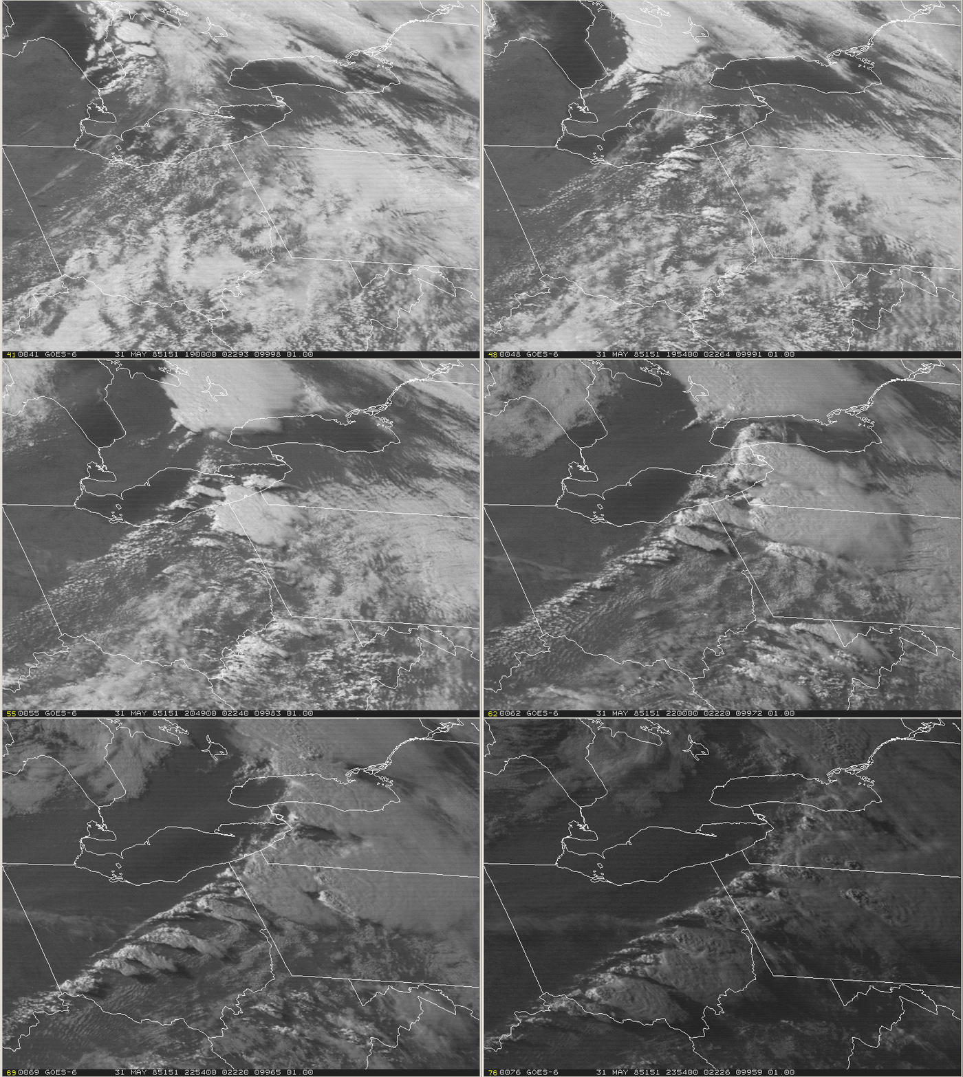
The visible satellite loop above shows the development and explosive growth of thunderstorms across southern Ontario, Ohio, western Pennsylvania and western New York on the afternoon of May 31st.
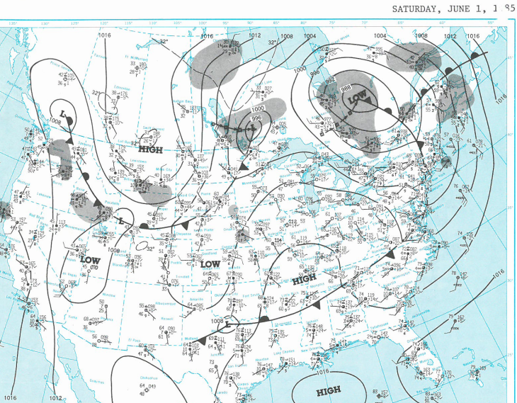
The thunderstorms were supported by a cold front moving east across the northeastern U.S. ahead of a low pressure system moving northeastward through the Great Lakes region. Unseasonably warm and humid air moved northward into Pennsylvania and much of the eastern U.S. ahead of the cold front, setting the stage for strong thunderstorms and tornadoes.
This two day series of Daily Weather Maps (courtesy NOAA/NWS) shows the eastward progression of the cold front; from near Chicago on Friday morning May 31st …

...to along the middle Atlantic Coast then westward through North Carolina by Saturday morning June 1st.
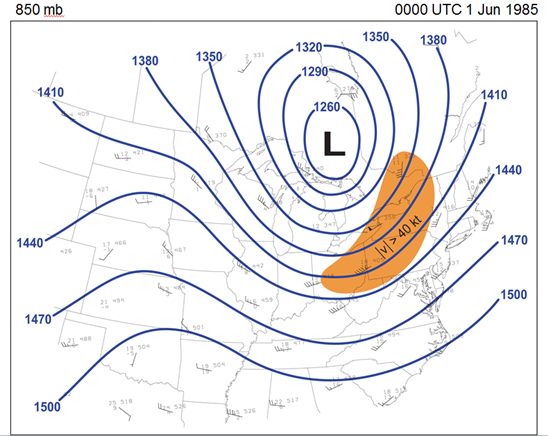
The fast eastward movement of the cold front is an indication of how strong (fast) winds aloft were blowing that day. The orange shading in the following 850 mb chart (from Markowski) shows where winds were greater than 40Kts (46MPH). Note the 50Kt ‘flag’ at Buffalo, NY. The 850mb level is about 5000 feet above the ground. Also note the deep closed low north of the Great Lakes.
The pink shading in the 300 mb chart (also from Markowski) shows where winds were greater than 100Kts (115 MPH). The 300mb level is about 30,000 feet above the ground.
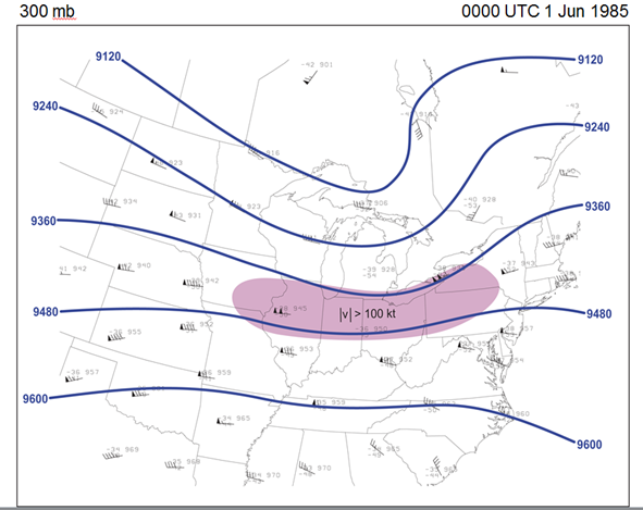
The increasing wind speed with height and change in direction, known as wind shear, is what helps thunderstorms to rotate and be capable of producing significant tornadoes. More on that later.
A closer view of the surface analysis of the warm sector, the area between the cold front and the warm front, at 7PM (23 UTC) Friday evening (courtesy Paul Markowski), shows how warm and especially how moist the airmass ahead of the cold front had become. Temperatures were in the 80s (F) and dewpoint temperatures (a measure of moisture) were in the upper 60s and lower 70s (F). Note the dewpoint temperature of 71 at Bradford, PA!
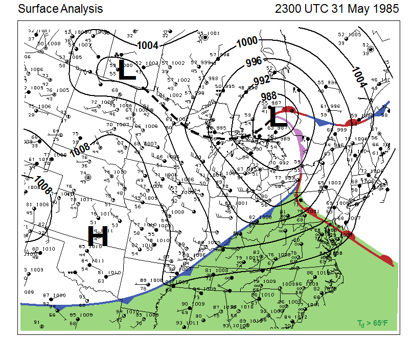
The three ingredients needed for thunderstorms are lift, moisture and instability. The cold front moving east provided the lift as it pushed into the warm sector and the dewpoints into the 70s show the available moisture. The following diagrams, called soundings, show the amount of instability in the atmosphere that afternoon.
Soundings are ‘created’ by plotting the data reported by weather balloons that are launched by the NWS each day all across the country. They are a measure of the conditions (temperature, dewpoints, wind speed and direction) above the surface of the Earth. The pink shading in the following sounding from Pittsburgh, PA at 7PM May 31st [00Z June 1st] (courtesy Paul Markowski) is an estimation of the Convective Available Potential Energy or CAPE in the atmosphere. The larger the number, the more instability is present, with CAPE of 2800 J/Kg , measured Friday evening being a moderate to high value.

Another measure of instability is the Lifted Index (LI). Negative LI values generally indicate unstable atmosphere, positive indicate lesser instability. This composite chart (courtesy Rihaan Gangat, NWS Pittsburgh) shows an expansive area of negative values with a bullseye of the lowest LI’s (most unstable air) over eastern Ohio and southwestern Pennsylvania.

The following sounding is from Dayton, Ohio (DAY) the morning of the 31st. Along the right hand side is a list of many of the parameters calculated from the sounding data, including CAPE and LI, that are used to predict thunderstorm occurrence and potential strength.
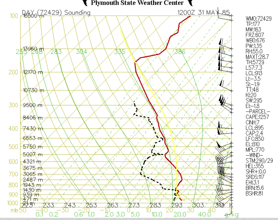
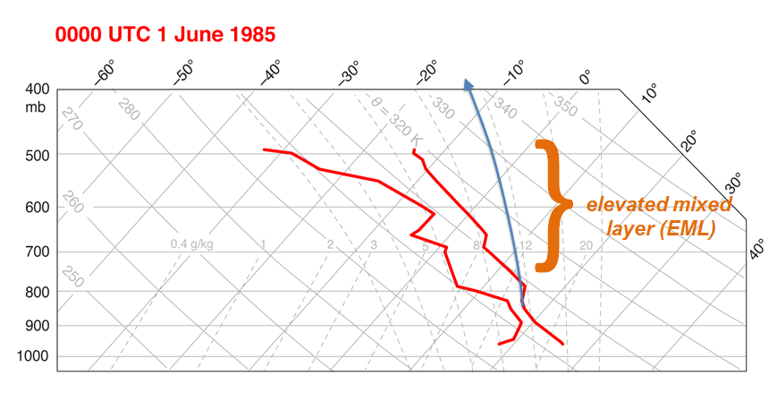
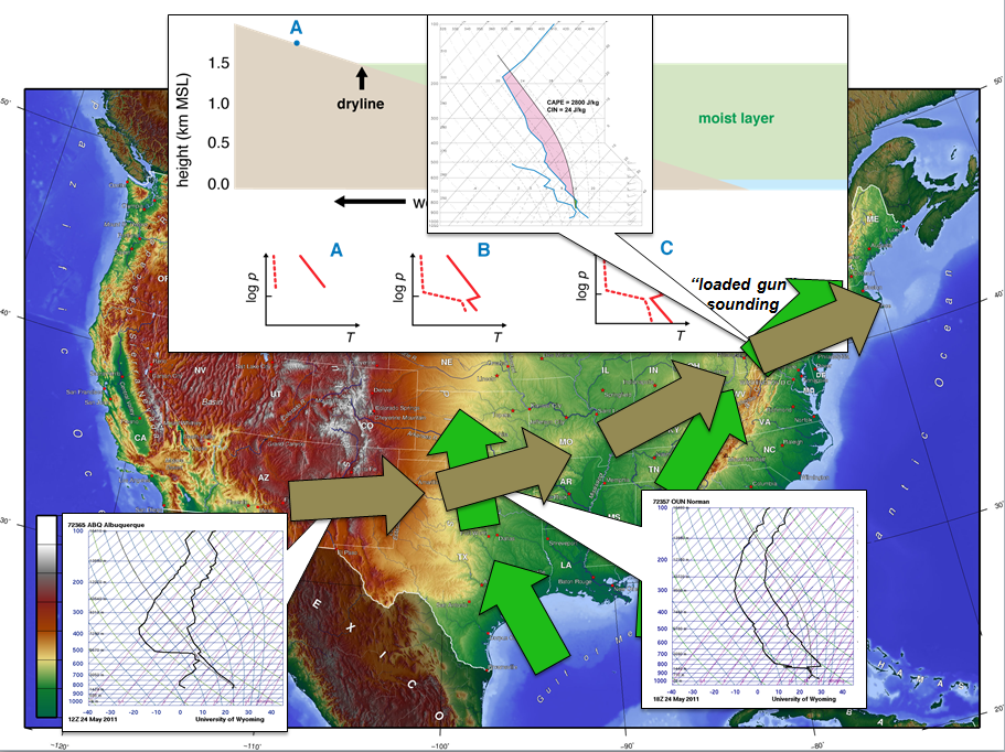
An additional component to the magnitude of the thunderstorms on May 31st was the presence of a significant “elevated mixed layer” (EML) , a common supporting ingredient in severe weather across the northeastern U.S. (Banacos and Ekster). EMLs act as a ‘lid’ in the atmosphere, stopping convection from occurring unless the lid can be removed or sufficient lift is present. The strength of the front and the degree of instability lead to the erosion or breaking of the cap and thunderstorms exploded with violent results.
This following two figures from Markowski show 1, the presence of the EML in the 7pm May 31st Pittsburgh sounding and 2, the formation and subsequent migration of the EML across the United States.
The following hand-analyzed upper air maps (provided by NWS Cleveland) from the morning of the 31st highlight the significant area of dry air (yellow shading) or ‘cap’ coming into play. The forecaster even analyzed a dryline (the bumpy blue line through the central Plains) on the 850mb map, showing the leading edge of the dry air.
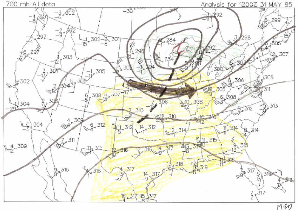
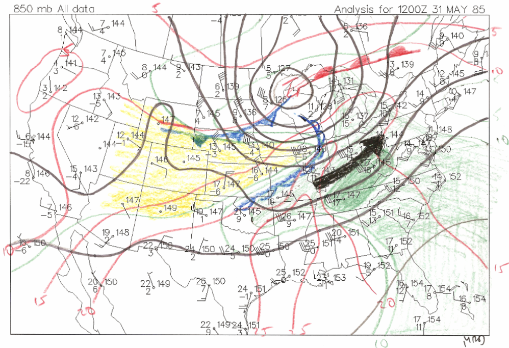
As mentioned earlier, wind shear, or more importantly wind shear of the right magnitude and direction, will cause thunderstorms to rotate, which is a precursor to tornado development. The wind profile captured by the Pittsburgh, PA sounding at 7am (12Z) Friday, May 31, shows a classic veering of winds with height, from southeasterly at the surface turning to southerly to southwesterly then westerly at mid and upper levels.

Conclusion:
The combination of moisture, instability, lift, and wind shear were present across a large area of the northeastern U.S. on May 31st. What happened next is history…historical damage and destruction.
Following are several images of what the thunderstorms looked like to meteorologist on radar. Radar images don’t show the actual tornadoes themselves (see the videos in the next section for that), but instead show structures or signatures within the storms that produce tornadoes. One classic signature is called a “hook echo”. Precipitation looks like a hook on the radar returns; showing rain, hail and sometimes debris caused by the tornado, spiraling inward around the tornado circulation.

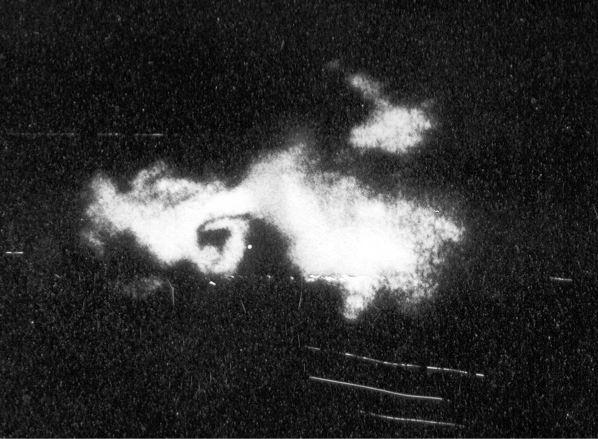
This image, courtesy Greg Forbes via Paul Markowski, is from the radar that was atop the Walker Building, home of Penn State Meteorology Department, around 8pm EST. It shows a pronounced hook echo (center of photo) within the storm moving through Moshannon State Forest about 20 miles north of State College, Centre County.
As noted in several summaries of this outbreak, including the official NWS damage assessment report, (NOAA/NWS October 1985):
“Perhaps the lesson to be learned from the 1985 outbreak is that under the proper atmospheric conditions, major tornadoes can occur irrespective of the location or terrain.”
Sources:
Banacos, Peter and M. Ekster: The Association of the Elevated Mixed Layer with Significant Severe Weather Events in the Northeastern United States. Weather and Forecasting.
Gangat, Rihaan. NWS Pittsburgh. May 31, 1985 Tornado Outbreak. Office severe weather training presentation.
Markowski, Paul: The Tornado Outbreak of May 31, 1985: Looking Back at One of Pennsylvania’s Deadliest Weather Events. PSU Department of Meteorology colloquium presentation; February 25, 2015.
Natural Disaster Survey Report to the Administrator of NOAA. The Ohio-Pennsylvania Tornadoes of May 31, 1985. October 1985. Silver Spring, MD.
References, Additional Links, and Acknowledgements
(BACK TO TOP)
Accuweather 25th Anniversary Blog Post
Beaver County Times - 10th Anniversary
Beaver County Times - Collection of 30th Anniversary Articles
Cleveland Plain Dealer - 25th Anniversary
Erie Times News - June 1, 1985
Erie Times News - June 2, 1985
Erie Times News - 20th Anniversary
Erie Times News - 30th Anniversary
Meadville Tribune - Photo Gallery
Pittsburgh Post Gazette - June 1, 1985
Pittsburgh Post Gazette - 20th Anniversary
Pittsburgh Press - June 2, 1985
Weather Nation May 31 Blog Post
Tornado Watch Number 211 by John G. Fuller, Published September 1st 1987 by William Morrow & Company
The Trib Today - 30th Anniversary
Youngstown Vindicator - Tornado Victims Remembered
NWS State College - 25th Anniversary
Supplemental Presentation by Nick Sleptzoff, former Erie County EMA director
NWS Storm Prediction Center Weather Report Archive
National Weather Service Assessment
NWS/NOAA Employees/Retirees Stephen Corfidi, Bob Davis, Bill Drazl, Thomas Dunham, Priscilla Farrar, Rihaan Gangat, Paul Head, Carolyn Kloth, Christopher Liscinsky, Bill Modzelewski, Paul Nieman, Rob Radzanowski, and Teresa Rossi for their recollections, images, and data
Tom Atkins, WJET/Fox 66 for images and video
Henry Margusity, Accuweather for video footage and images
Dr. Paul Markowski and Lee Grenci, Penn State University for images, information, and recollections
Curtis Bowley, Susan Lucas Kazenas, and Ed Kieser for their recollections
Elyse Hagner and William Gartner, NWS State College, PA
Zachary Sefcovic, NWS Cleveland, OH