
Unseasonably warm temperatures continue through the weekend across the Southwest and southern U.S., with more than 100 record or near record maximum temperatures forecast through the rest of the week and over the weekend. Elevated to critical fire weather conditions will persist across the Plains and Southeast U.S. this weekend. Read More >

Overview | Meteorological Background | Flooding | Resident Accounts
During the first week of September in 2011, heavy rain from the remnants of Tropical Storm Lee, led to historic flooding in the Mid-Atlantic Region and especially Central Pennsylvania. The flooding was exacerbated by the saturated soil from previous heavy rain, just a week earlier from Hurricane Irene. The extensive damage caused by the flooding had not been seen since Hurricane Agnes devastated the area back in 1972. Rivers overflowed their banks, towns flooded, bridges washed away. A total of 15 people lost their lives as a result of the flooding, including 7 from Pennsylvania. The majority of these people were in vehicles trying to cross flooded roadways and were swept away. In Pennsylvania, over 16,000 homes and businesses received at least minor damage, including over 1,000 homes and businesses that were completely destroyed. Total estimated damage costs from Tropical Storm Lee are over $2 billion.
Extremely saturated ground augmented the flooding from the remnants of Tropical Storm Lee. Pennsylvania had already received heavy rains during the month of August, and most areas were above average for the month. Then, during the final week of August, Hurricane Irene brought additional heavy rain and flooding to Central and Eastern Pennsylvania, where some locations picked up to 6 inches. In this saturated condition, the rainfall associated with Lee couldn't be absorbed into the soil and immediately ran off. This led to rapidly rising streams, which quickly endangered people and property.

Total August precipitation by county (top number), departure from average August precipitation (bottom number), and color denotes percentage above or below normal.

Total rainfall from Hurricane Irene just two weeks before Tropical Storm Lee flooded the area.
Tropical Storm Lee formed in the Gulf of America on September 2nd about 220 miles southwest of the mouth of the Mississippi River. Lee reached its maximum intensity on September 3rd, with 60 mph sustained winds and a central pressure of 986 millibars. Also on the 3rd, Lee began to merge with an upper level low and took on some subtropical characteristics. Lee made landfall on the morning of September 4th, along the coast of Southern Louisiana. After making landfall, Lee remained nearly stationary over Louisiana for the remainder of the 4th. On September 5th, Lee merged with an unseasonably strong cold front and became extratropical.

The 3 types of cyclones. Cyclones can transition from one type to another.
Meanwhile in Central Pennsylvania, the record flood event began with frontal precipitation beginning on the 4th. The unseasonably strong cold front surged moisture northward from the Gulf of America as it stalled over the Appalachian Mountains. The frontal rain continued into September 6th, as well as the beginning of September 7th. Widespread 2-4 inches of rain fell September 4th and 5th.
Satellite view of the formation of Tropical Storm Lee, and its progression up the East Coast.
On September 6th the west-east orientated frontal rain bands declined. These were replaced by south to north orientated rain bands associated with the remains of Tropical Storm Lee, which had tracked into the southern Appalachians at this time. Lee's location enabled an anomalously strong southerly flow over Virginia and Pennsylvania to form, and transport even more Gulf of America moisture northward. This flow combined with the lifting over the northern Chesapeake Bay due to the stalled frontal boundary, set the stage for extreme rainfall to take place. An additional 2-5 inches fell on September 6th across a large area of central Pennsylvania. On September 7th the rain bands became more isolated and trained over the same areas leading to 6-9 inches of rain falling over parts of the Susquehanna valley. The rain finally trailed off on September 8th as the front and the remnants of Lee moved across the Delmarva and over the Atlantic Ocean.
Radar of the remnants of Tropical Storm Lee, and associated cold front.
Precipitation totals from September 4th to the 8th over the Susquehanna valley topped 10 inches in many locations, with a large swath of central Pennsylvania receiving over 6 inches. All of this water had to go somewhere and this led to some record breaking flooding.
Minor river flooding began late on September 6th, and quickly escalated on the 7th. Moderate to major rises were forecasted at this point, leading to widespread river flood warnings. These initial forecasts proved to be too low, as it was unknown that over the next 24 hours many locations in the Susquehanna Valley would receive over 8 additional inches of rain. During the deluge, river forecasts adjusted to the large amounts of water that were filling the basins, and began forecasting major to record flooding. By the evening of September 7th smaller streams like the Swatara Creek and the Loyalsock Creek were experiencing record flooding. By the morning of the 8th, the flooding had spread to both the West Branch and the main stem of the Susquehanna River.
The Swatara creek is a 72 mile tributary of the Susquehanna River which runs to the north of Hershey. From September 5th to the 8th, Hershey received 12.18 inches of rain from the remnants of Tropical Storm Lee, including 6.98 inches on the 7th. Minor flooding began the morning of September 7th, when the Swatara Creek began to overflow. The creek reached moderate flood stage by the afternoon and quickly jumped to major flood stage within 3 hours. At this point numerous homes adjacent to the creek were affected by flood water, and Route 39 began to cover with water. The Swatara creek broke its record stage of 16.12 feet a few hours after this, and kept rising. It crested at 26.80 feet (over 10 feet above its record stage!) around 24 hours later, in the evening on September 8th. Areas in and around Hersheypark were under feet of water. Many area roads were impassable due to flooding, and numerous homes and businesses were flooded.

The Swatara creek basin.
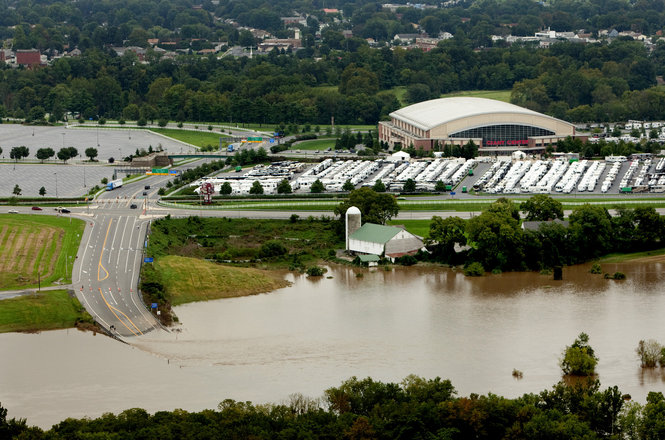
Flooding on Rt. 39 in Hershey leading to the Giant Center. Image courtesy of Sean Simmers, The Patriot News.
Flooding north of Middletown along the Swatara creek, completely isolating this house.
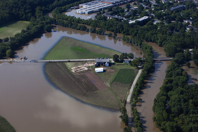
Loyalsock Creek is a 64 mile tributary of the West Branch of the Susquehanna River. The creek runs through Loyalsockville before entering the Susquehanna in Lycoming County. Loyalsockville received 9.70 inches between September 4th and 8th including 5.09 inches on September 7th. The creek quickly responded to this heavy rainfall, rising almost 15 feet in just over 12 hours, on its way to breaking its record stage (the exact crest stage is missing because the gage stopped reporting). Major flooding occurred along the creek in Montoursville where many properties were inundated. North of town, in Loyalsockville, the PA 973 bridge over the creek was washed out, while the Green Bridge and nearby railroad bridge were damaged, but survived. Further upstream at World's End State Park, the creek destroyed a bridge that led to the campground. Campers were evacuated from the area before significant flooding isolated the area. Parts of PA 154, the only major travel route, were underwater and suffered structural damage.
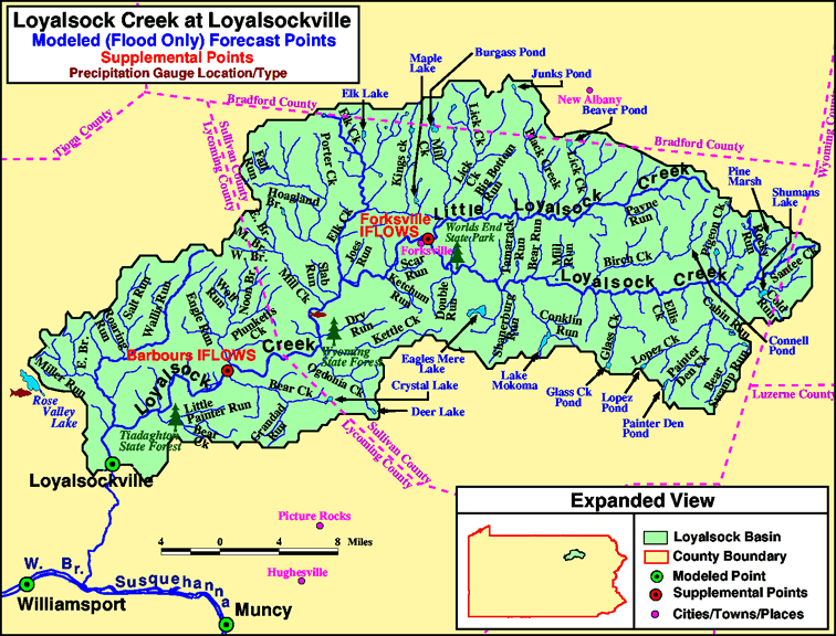
Loyalsock Creek basin.

The washed out PA 973 bridge over Loyalsock Creek near Loyalsockville. Image courtesy PA State Police.
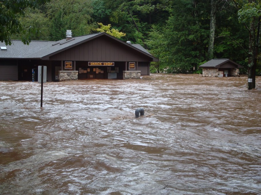
World's End State Park Campgrounds. Image courtesy PA State Parks.
The Susquehanna River flows 444 miles on its way to the Chesapeake Bay and passes through the town of Bloomsburg. Fishing creek also flows just north and west of town on its way to the Susquehanna River. Flooding began on the 7th, when the creek started overflowing its banks. Roads began to flood in town, and water began to enter some homes. The flooding intensified on the 8th, when roads turned to rivers, and people began to evacuate their flooded homes. The Fernville Bridge, over Fishing Creek, was partially underwater at this point and turned out to be heavily damaged. The Bloomsburg fair grounds were overrun by the flood waters, as was over a quarter of the town of Bloomsburg. The Susquehanna River crested at its second highest level on record, at 32.75 feet.

The Upper main stem Susquehanna River basin. Also note Fishing Creek, which runs and north and west of Bloomsburg.

Flooding in downtown Bloomsburg. Image courtesy of BloomUtoday.com
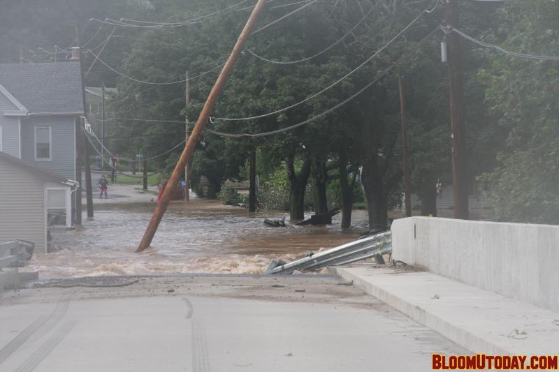
Flooding at the Fernville Bridge over Fishing Creek. Image courtesy of BloomUtoday.com
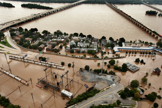
The Susquehanna River also flows through the center of the Harrisburg metro area. River flooding began on the 8th when rising water began impacting homes and businesses along the river banks, and also on City Island. By the 9th, City Island was covered by over 7 feet of water, and the waterfront neighborhood of Shipoke was completely submerged. Many waterfront properties became flooded to their second story in Harrisburg, and across the river in New Cumberland.

Lower stem Susquehanna River basin.
Flooding in the Shipoke neighborhood bordering the Susquehanna. Image courtesy Sean Simmers, The Patriot News.

The muddy Metro Bank Park field on City Island after the waters receded. Image courtesy Sean Simmers, The Patriot News
"I was nervous going over(the flooded bridge), until some guy drove over it earlier and I said, oh we can probably make it across, we've been going all the way around, 5 miles up that way. We had some horses that were stuck in the run-in over here. We let them out earlier and then took them up onto higher ground and fed them." (WNEP)
"This was worse than '72, no doubt about it, and due to the fact that it just happened so quickly and people weren't prepared." (WNEP)
"We have been very fortunate in getting early warnings so we usually take things out of the basement, especially the freezer. This time we went to bed and we were sure there was going to be time in the morning and when we woke up in the morning it was all flooded out." (WNEP)
"At four o'clock in the morning the police came to our doors, told us to move our cars. At 6:30 in the morning, we had a mandatory evacuation." (WNEP)
"It came quick, it came real quick. They knocked on my door probably about 10 minutes before the water came down to evacuate, that's what we had, that moment." (WNEP)
"It's horrible man, can't stay here, got to go live with other people it's crowded, it stinks. In '72 it didn't flood here, so we didn't have to have (flood insurance), we didn't think anything of it." (WNEP)
"Just to watch it all disappear, like I said within 200 yards of either side of my house, two houses are missing, two garages are missing and an entire business is gone." (WNEP)
"It's cool. The whole community coming together, people from high school, middle school and members of the community, just to help out our town in a communitive effort." (WNEP)
"It hit them in a blink of an eye. We were rescuing people on the way to rescuing people. There was no time for introductions or salutations. We were dispatched every 90 seconds for hours." (Patriot News)
"We've always had Christmas and Thanksgiving here. This was our home. We made a lot of memories here." (Patriot News)
"If we'd have waited 15 minutes, I don't think we would have gotten out. We survived. Everything else can be replaced." (Intelligencer Journal/Lancaster New Era)
"My husband's been pumping water from the basement, but it keeps coming in through the walls. What could we have done? Just watch and panic. I feel fortunate because we only lost a few things." (Intelligencer Journal/Lancaster New Era)
In Pennsylvania, the flooding from Lee rivaled Agnes in terms of magnitude and scope. Some of the hardest hit areas will remember Lee for producing record flooding, as well as flooding places that didn't flood during Agnes. The preceding heavy rain from Hurricane Irene also played an important role in the severity of the flood. The combination of heavy rainfall and the saturated ground led many creeks to quickly rise over a short period of time. Residents were unprepared for the rising water, and had to make fast decisions to ensure their safety. After the storm, communities came together to clean up, rebuild, and prepare for the next flood.

Surface analysis from August 25th to September 9th, showing the development and progression of Hurricane Irene, Tropical Storm Lee, and the cold front that absorbed Lee.
Videos
Flooding in Glen Rock, York County
Flooding in Hummelstown/Hershey, Dauphin County
Flooding in Lykens Glen, Dauphin County
Flooding in Bloomsburg, Columbia County
Flooding at Knoebels Amusement Park, Northumberland County
Pictures
Flooding in the Susquehanna Valley
Flooding in World's End State Park
Brown, Daniel P.: Tropical Cyclone Report. Tropical Storm Lee. National Hurricane Center. December 2011.
Grumm, Richard H.: Heavy rainfall associated frontal interactions with Tropical Storm Lee. National Weather Service State College, PA. September 2011.
Articles
Chan, C.C.: Extratropical Cyclone vs. Tropical Cyclone. Hong Kong Observatory.
https://www.hko.gov.hk/education/edu01met/01met_tropical_cyclones/ele_typhoon3_e.htm
Kemeny, Matthew: Floodwaters recede, but Death Toll Continues to Rise. The Patriot News. September 2011.
https://www.pennlive.com/midstate/index.ssf/2011/09/flood_waters_recede_but_death.html
Hamill, Jim: Unprecedented Flooding Devastates Parts of Lycoming County. WNEP. September 2011.
Hartman, Trish: Levee Breach in Danville. WNEP. September 2011.
Komenda, Ed: Middletown Residents Affected by Flooding Wonder if They'll Live in Their Homes Again. The Patriot News. September 2011.
https://www.pennlive.com/midstate/index.ssf/2011/09/post_245.html
Lange, Stacey: Cleanup in Shamokin and Coal Township. WNEP. September 2011.
Lee, Peggy: Lewisburg Cleans Up After Flood Waters Recede. WNEP. September 2011.
Lee, Peggy: Muncy Creek Floods Hughesville Area. WNEP. September 2011.
Lee, Peggy: Roads Flooded in Columbia County. WNEP. September 2011.
Murse, Tom: As Cleanup Begins, Tales of Survival in Manheim. Lancaster Online. September 2011.
Page compiled by Shane Kearns NWS State College


 Send Us a Report