|

"It was Spring Break for Penn State in 1993..." is how some of our office staff start their favorite recollections of the "Storm of the Century." It's tough to forget 2 to 3 feet of snow, nor the resulting massive piles of snow in the parking lots on campus that lasted into April that year. An epic snow of 27.5" fell in State College (Walker Building on PSU campus) from the pre-dawn hours of Saturday the 13th into the morning of Sunday the 14th. Travel was disrupted for days following the storm all along the eastern third of the country. Many students were not able to return from their vacation destinations for the anticipated start of classes on Monday. |
|
The storm affected over 100 million people and caused billions of dollars in damage. The heaviest snow fell from the southern Appalachians to the Canadian border with some locations reporting over 40 inches. The storm has been classified as a Category 5 (Extreme) on the Northeast Snowfall Impact Scale (NESIS) rating system. The Northeast Snowfall Impact Scale (NESIS) developed by Paul Kocin and Louis Uccellini of the National Weather Service (Kocin and Uccellini, 2004) characterizes and ranks high-impact Northeast snowstorms. As of this writing, March 2023, this "Storm of the Century" is ranked as number 1 on the NESIS list, well ahead of second place Jan 6th-8th Blizzard in 1996. This storm produced a myriad of weather as it rolled up the East Coast in Mid-March: Severe thunderstorms and tornadoes in the south, and huge snowfalls over the Appalachian Mountains. In Florida the storm packed hurricane conditions with a massive storm surge that swept houses out to sea and produced over 27 tornadoes. (Kocin and Uccellini) Even New York City and Philadelphia picked up around a foot of snow. https://www.ncei.noaa.gov/news/1993-snow-storm-of-the-century |
|
Storm Total Snowfall Map March 12-14, 1993 |
 |
Satellite Images

Visible Satellite Image from GOES 7, 1800Z 3 March 1993

Meteosat Infrared Satellite Image, 1200Z 13 March 1993
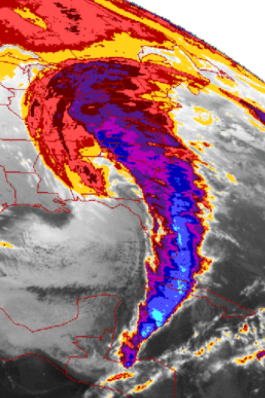
IR Satellite Image 13 March 1993

(NOAA Archives)
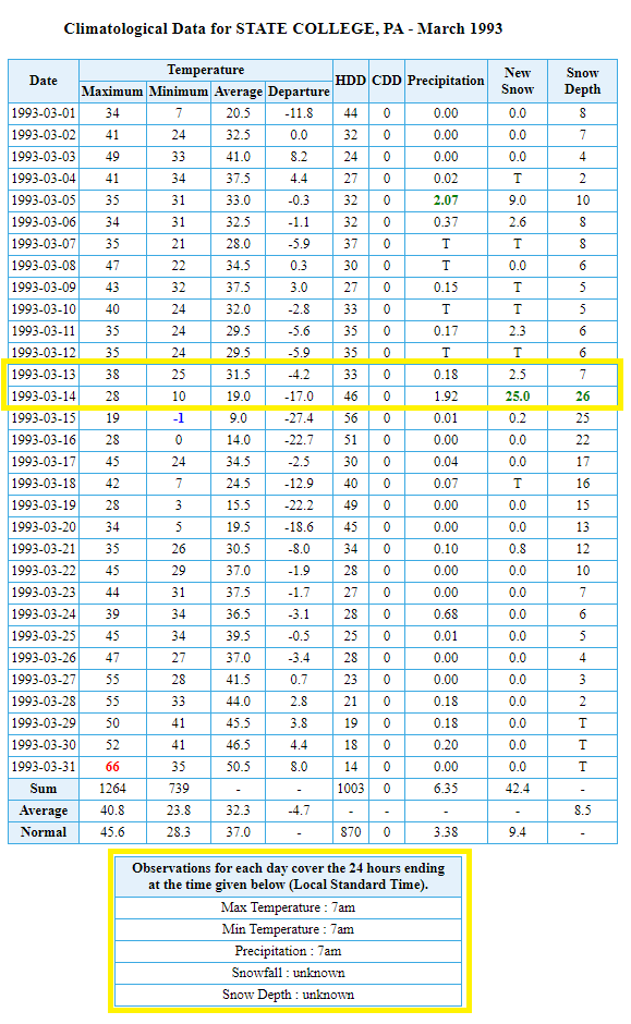
March 1993 PSU Walker Building observations (taken once per day at 7AM for the past 24 hrs)


 Send Us a Report