|
|
|
|
|
National Weather Service State College, Pennsylvania |
Spring 2000 |
|
Flood Climatology of Pennsylvania
Tornado Climatology of Pennsylvania
|
New Computers Served Up a Fast One
Spotter Reports Still Essential
|
|
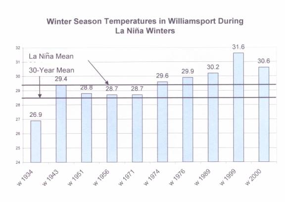
La Ni�a, the cool waters off the west coast of the Americas, remained strong through the winter of 2000.� Low pressure storms took a persistent track east from the Pacific Northwest to the Great Plains and northeast.� This meant few events had access to a good supply of Gulf or Atlantic moisture.� It also minimized chances for outbreaks of Canadian cold air.� The result:� temperatures were above normal and snowfall below normal across our entire central Pennsylvania area.� At Harrisburg, the winter ended 2.6� above normal at 34.1�, compared to a mean of 31.5�.� Winter temperatures for Williamsport are shown in the graph below.
|
|
Most recent information from different computer forecasts indicate a weakening of the cold waters back to near normal temperatures through the summer months, or even return to a warm episode rather rapidly.� Current equatorial easterly winds tend to point to a slow transition.� What does this mean for our summer?� Long range predictions are for above normal temperatures and below normal precipitation through the early part of summer.
One of the latest programs gaining speed in the weather service and emergency management community is termed StormReady Accreditation.� Developed to recognize those communities or counties that have excellent communications systems, multiple access to weather warning information, effective spotter networks, and a means of alerting their populations, StormReady went nationwide this spring after introduction in Oklahoma in the late 1990s. Pennsylvania has one of the best emergency management organizations in the nation, and many counties should meet criteria for accreditation with only minimal changes in their preparedness plans and activities.� Spotter programs, public awareness drills, and training are an integral part of the StormReady program.� Weather service offices will be providing added details to the counties in the months ahead.� Certainly, those counties with active SKYWARN programs will be at the head of the list for certification.
|
|
Like virtually everyone else, the National Weather Service managed to survive the great Y2K scare with little, if any, problems.� Never had so many spent so much to accomplish so little, just to tell what day it was. Some of our SKYWARN people spent the evening at emergency centers ready to provide emergency communications should power or phone systems fail.� In the end, we all let out a sigh of relief that computer systems, that are absolutely essential to our day-to-day lives as well as for weather forecasts and warnings, performed flawlessly.� Y2K had positive benefits, since it made people think of what they would do in an emergency.
|
|
For the past 3 years, the National Weather Service in Pennsylvania has been providing a series of hazardous weather and flood preparedness courses to people in the emergency management community.� Much more detailed then the SKYWARN program, the training actually lasts for 2-1/2 days, and includes a mock tabletop exercise of a tornado event striking a major city in the state.
It's a program sponsored by PEMA and open to members of the emergency management community.� If you are active in the SKYWARN program, but work in some part of emergency management, you might find the course of interest.� It is generally scheduled once in the late winter and once in late fall.
|
|
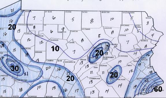
Flood Climatology of Pennsylvania Pennsylvania ranks among the top states in the nation in flooding.� Texas is number one in flood fatalities (thanks in large part to the state's huge area).� Pennsylvania ranks number six. If size were taken into consideration, the top three states for flood fatalities would be West Virginia, Virginia, and Pennsylvania, in that order.� These Middle Atlantic states are all within the Appalachian chain of mountains, and they all have access to two major sources of water.� West of the mountains, moisture feeds in from the Gulf of America.� Eastern sections of these three states see high levels of moisture from the Atlantic Ocean.� All are also open to remnants of tropical storms from the Atlantic and the Gulf.
The map below relates floods per 500 square miles, an area about the size of Adams or Sullivan County.� Do you think urbanization has an effect on flooding?
|
|
Tornado Climatology of Pennsylvania Although Pennsylvania is not considered to be a tornado prone area, in an average year nearly a dozen such storms are expected across the state.� 1999 was below average with just 9 tornadoes reported.� That compares with 1998 when 60 were documented, 40 in the matter of 3 days.
This map, like the flood map, rates the number of tornadoes per 500 square miles since 1950.� Tornado data is kept by county, but some counties are twice as big as others.� Using 500 square miles (about the size of Adams or Sullivan County) makes all areas equal, for better comparison.� This tends to even out the distribution of storms, although several areas stand out. Western PA, from Johnstown and Somerset north to the New York border, is an active area.� The lower Susquehanna Valley, from Gettysburg and Harrisburg east to Philadelphia, is also a high frequency area.� The central mountains from border to border show fewer storms than anywhere else.
|
|
New Computers Served Up A Fast One Maybe it was a bit early, but within days of the announcement of the installation of the new IBM super computer, Mother Nature served up a real spring training curveball.� The new systems increased computation speeds to 690 billion times per second and, by September, will be upgraded to 2.5 trillion calculations per second.� As if to confirm that she still has a few surprises in store, and maybe a humble reminder, Mother Nature launched the January 25th storm, fooling a lot of people, some of our best forecasters, and of course our best computer.� Surprise is not a new word in the weather vocabulary, but there is absolutely no question that faster and better computers have made our forecasts and our warnings far superior to those of just a decade ago.� With time, and maybe some tweaking, the new computers will also improve our products.
|
|
In March, we had a chance to visit the Sunbury Flood Control Project where EMWIN was recently installed.� EMWIN is a direct satellite receiving virtually all weather service forecasts and warnings from anywhere in the U.S.� That day, tornado warnings rolled in from Ohio where spring drills were taking place.� The system sells for less than $1,500, including receiving dish, converter equipment, and software to process the data. Software is also available for less than $100 for pulling the same data off the internet.� If you are interested in EMWIN, there are a number of internet pages available.� Just do a search on EMWIN and you will find several links.
|
|
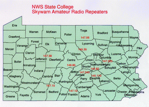
Each spring, I like to review the frequencies that we monitor to talk to central PA hams.� The map below shows the locations and frequencies we listen to during severe weather.
|
|
Speaking of monitoring ham radio frequencies, we now have a new amateur on station.� Dave Ondrejik (K3NWS), our Service Hydrologist (he's also a meteorologist), passed the technician exam and will soon be operating our station along with me and the volunteers from the State College area.� It will be nice to have an extra hand to operate when storms pop up in the early afternoon when it's hard to find a volunteer.� We hope to have the station running more frequently this season.
|
|
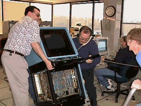
The final step in our modernization process was completed this spring with the commissioning of our Automated Weather Information Processing System, or AWIPS.� The new computer systems mean huge changes in the way we issue tornado, flash flood, and severe thunderstorm warnings.
Don Shaffer, Mike Dangelo, and Paul Head (on the phone) remove the 1980's vintage AFOS equipment.� Paul was so eager to see the old system go that he didn't even get off the phone.� We all agree that the new systems are far superior. No longer do we manually type information about storms and their tracks.� Now, with a few clicks of a mouse, AWIPS computes the track, calculates time to a town, and composes the warning ready for transmission.� It saves precious minutes off composition times to issue warnings and cuts down on errors.
|
|
Spotter Reports Still Essential Even with the best and fastest computers, there is still a crucial need for eyewitness reports.� Radars can identify rotation in storms, but because they sample thunderstorms well off the surface of the earth, radar cannot tell us that a tornado has touched down or if, in fact, flooding has begun.� Hail, damage to trees and buildings, and rainfall amounts can only be verified through visual reports.
Information to Report
|
|
I'm on the road again for SKYWARN training, and hope to be at a hall near you soon.� Training is listed on our homepage:� http://bookend.met.psu.edu, or call your emergency management office for details.� Thanks for your help!
N2KBI Tom Dunham
|
This page created by:
Administrative Assistant
National Weather Service
State College, Pennsylvania


 Send Us a Report