
A Pacific storm system will continue to bring low elevation rain and mountain snow to much of the West through Wednesday, with heavy mountain snow expected in the higher elevations of the Sierra Nevada. This system will also bring strong winds to the Intermountain West, Rockies, and Plains, which will create Critical fire weather conditions for the High Plains. Read More >
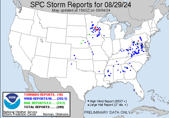
Severe Weather
(One Tornado and areas of Wind Damage)
Occurred on August 29th, 2024
Tornado Details:
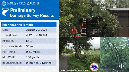
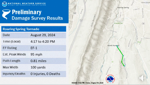
Public Information Statement National Weather Service State College PA 856 PM EDT Fri Aug 30 2024 ...NWS Damage Survey for 08/29/24 Tornado Event in Roaring Spring PA... .Roaring Spring Tornado... Rating: EF1 Estimated Peak Wind: 95 mph Path Length /statute/: 0.81 miles Path Width /maximum/: 100 yards Fatalities: 0 Injuries: 0 Start Date: 08/29/2024 Start Time: 04:17 PM EDT Start Location: 1 SSW Roaring Spring / Blair County / PA Start Lat/Lon: 40.3169 / -78.4082 End Date: 08/29/2024 End Time: 04:20 PM EDT End Location: 2 S Roaring Spring / Blair County / PA End Lat/Lon: 40.3066 / -78.4033 Survey Summary: A severe thunderstorm over southern Blair County spawned a tornado late in the afternoon on Thursday, August 29th. The tornado was on the ground for about 3 minutes, with a track length of just under a mile. The tornado path started in Roaring Spring Township, just east of State Route 867 and near a motorcycle repair shop. One to two dozen trees were either snapped or uprooted in this vicinity, with one of the trees landing on the garage of the repair shop and heavily damaging the roof. This is the point where the tornado peaked in intensity, producing maximum winds near 95 mph, which is in the EF-1 category. The tornado then moved south-southeast, roughly paralleling Dick Schoolhouse Road, producing sporadic areas of tree damage, with winds mostly between 65 and 85 mph. Near the end of the path length, just east of Dick Schoolhouse Road, about halfway between Orchard Road and Packing Shed Lane, the tornado flattened a narrow swath of crops in a cornfield. Shortly thereafter, the tornado dissipated. && EF Scale: The Enhanced Fujita Scale classifies tornadoes into the following categories: EF0.....65 to 85 mph EF1.....86 to 110 mph EF2.....111 to 135 mph EF3.....136 to 165 mph EF4.....166 to 200 mph EF5.....>200 mph NOTE: The information in this statement is preliminary and subject to change pending final review of the event and publication in NWS Storm Data. $$ |
Additional damage from thunderstorm wind gusts
occurred in Mill Hall, PA (Clinton County) and
Mifflintown, PA (Juniata County) that day.
Mill Hall Damage:
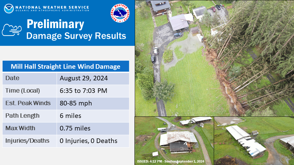
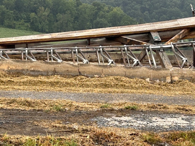
Public Information Statement National Weather Service State College PA 1136 AM EDT Sun Sep 1 2024 ...NWS Damage Survey Confirms 08/29/2024 Thunderstorm Wind Event in Clinton County... .Mill Hall Thunderstorm Wind Damage... Peak Wind /Est/: 80-85 mph Path Length /statute/: 6 miles Path Width /maximum/: 0.75 mile Fatalities: 0 Injuries: 0 Start Date: Aug 29, 2024 Start Time: 6:35 PM EDT Start Location: 4 SSE of Glen Union in Clinton Co, PA Start Lat/Lon: 41.18307/-77.55283 End Date: Aug 29, 2024 End Time: 7:03 PM EDT End Location: 1 NW Mill Hall in Clinton Co, PA End Lat/Lon: 41.11640/-77.50278 Survey Summary: Between 6:35 PM and 7:03 PM Thursday, Aug 29, 2024, a supercell thunderstorm produced straight line wind damage within its forward flank downdraft over a portion of Clinton County near Mill Hall. Most of the damage occurred in an area measuring 6 miles long and up to 0.75 miles wide, with estimated maximum winds of 80-85 mph. Numerous trees were pushed down in a southerly direction in the valleys from the West Branch Susquehanna down through Shade Hollow and then into Bald Eagle Creek. Sporadic damage was also found outside of this area, in a larger area measuring up to 3 miles wide. The National Weather Service conducted a storm survey in Clinton County on Friday, Aug 30. Tree damage was observed on both sides of Renovo Rd (Rt 120) just south of Eagleton Rd. It is estimated that this damage occurred at about 6:35 PM on Thursday, Aug 29. As the thunderstorm moved towards the southeast, it produced damage along Sugar Run Rd near Shade Hollow Rd, ripping pieces of roof off of two barns, and knocking down a few trees. The property owner took a video of golf ball sized hail falling at 6:52 PM. A few more trees were downed along Shade Hollow Rd farther to the southeast. Some of the most notable damage occurred off Creek Rd between Cottage Ln and Daisy Ln, including a row of 20+ pine trees that came down on one property at around 7:00 PM Thursday. Winds in this area were estimated near 85 mph. A partially connected root system and very wet soils likely made it easier for the trees to come down. Some of the trees fell onto a house. A utility pole with a transformer and wires also fell. Sporadic wind damage also occurred in the towns of Flemington and Lock Haven. A fence fell onto a car in Flemington, resulting in the entrapment of 1 person who was uninjured. A tree also fell across the road on the 300 block of West Water St in Lock Haven. We would like to thank the Clinton County Department of Emergency Services for their time and assistance in this storm survey. && NOTE: The information in this statement is preliminary and subject to change pending final review of the event and publication in NWS Storm Data. $$ |
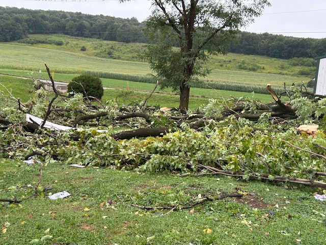
Mifflintown Damage Pictures:
 |
 |
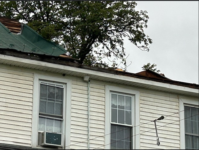 |
Public Information Statement
National Weather Service State College PA
437 PM EDT Tue Sep 3 2024

...NWS Damage Survey for 08/29/24 Thunderstorm Wind Event...

.Mifflintown Thunderstorm Wind Damage...

Peak Wind /Est/:        85-95 mph
Path Length /statute/:  2 miles
Path Width /maximum/:   0.6 mile
Fatalities:             0
Injuries:               0

Start Date:             Aug 29, 2024
Start Time:             9:47 PM EDT
Start Location:         3 SSW Mcalisterville
Start Lat/Lon:          40.59/-77.30

End Date:               Aug 29, 2024
End Time:               10:06 PM EDT
End Location:           4 WSW Thompsontown
End Lat/Lon:            40.55/-77.30

Survey Summary:
Between 9:47 PM and 10:06 PM on Thursday, August 29, 2024,
a supercell thunderstorm produced straight line wind damage
east of Mifflintown. The most extensive damage was to a couple
of residences along Cedar Springs Road, with additional damage
extending two miles south to just south of U.S. Highway 322 along
William Penn Highway. The damage was about 0.6 miles wide with peak
estimated wind speeds of 85-95 mph.

The roofs of two residences along Cedar Springs Road were heavily
damaged as portions of them were blown off to the south and southeast.
Additionally, the side of a large open barn was blown over. Here and to
the south, multiple trees either had their trunks snapped off or were
blown over. This led to downed wires and subsequently multiple road
closures. The southern extent of the brunt of the damage was found along
William Penn Highway where a large tree was blown down and blocked the
highway.

The National Weather Service in State College would like to thank the
Juniata County Department of Emergency Services for their time and
assistance with this damage survey.


&&

NOTE:
The information in this statement is preliminary and subject to
change pending final review of the event and publication in NWS
Storm Data.

$$
 |
Preliminary Local Storm Report...Summary
National Weather Service State College PA
924 PM EDT Fri Aug 30 2024

..TIME...   ...EVENT...      ...CITY LOCATION...     ...LAT.LON...
..DATE...   ....MAG....      ..COUNTY LOCATION..ST.. ...SOURCE....
            ..REMARKS..

0417 PM     Tornado          1 SSW Roaring Spring    40.32N 78.41W
08/29/2024                   Blair              PA   NWS Storm Survey

            An EF1 Tornado was confirmed south-southwest
            of Roaring Spring. Estimated maximum wind
            speed 95 mph with a path length of 0.81
            miles. Width estimated to be 100 yards.

0652 PM     Hail             3 NW Mill Hall          41.14N 77.53W
08/29/2024  M1.75 Inch       Clinton            PA   Emergency Mngr

            reported via EMA video.

0417 PM     Tstm Wnd Dmg     1 SSW Roaring Spring    40.31N 78.40W
08/29/2024                   Blair              PA   911 Call Center

            Multiple trees down along Dick Schoolhouse
            Road with some near the intersection of
            Orchard Road.

0417 PM     Tstm Wnd Dmg     1 S Roaring Spring      40.32N 78.39W
08/29/2024                   Blair              PA   911 Call Center

            Multiple trees and wires down along Cabbage
            Creek Road and Woodbury Pike with some
            blocking roadways.

0425 PM     Hail             Berlin                  39.92N 78.95W
08/29/2024  M1.25 Inch       Somerset           PA   Emergency Mngr


0430 PM     Hail             3 E Claysburg           40.29N 78.39W
08/29/2024  M1.00 Inch       Blair              PA   Public

            Reported with a picture on social media,
            hail continued for 5 to 10 minutes.

0442 PM     Tstm Wnd Dmg     2 ENE Claysburg         40.30N 78.42W
08/29/2024                   Blair              PA   Public

            Multiple trees and wires down blocking
            Bloomfield Road between the intersections of
            Main Street and Cross Cove Road.

0454 PM     Tstm Wnd Dmg     3 NNW Woodbury          40.27N 78.38W
08/29/2024                   Bedford            PA   Public

            Numerous trees down along and on Frosty
            Hollow Road.

0508 PM     Flash Flood      Johnstown               40.33N 78.92W
08/29/2024                   Cambria            PA   911 Call Center

            Multiple vehicles in water with water
            rescues. Multiple flooded roadways in and
            around Johnstown.

0514 PM     Hail             1 S Carlisle            40.19N 77.20W
08/29/2024  M0.88 Inch       Cumberland         PA   Trained Spotter


0516 PM     Tstm Wnd Dmg     1 WSW Carlisle          40.20N 77.22W
08/29/2024                   Cumberland         PA   911 Call Center

            Reports of two trees down in Carlisle.

0549 PM     Flash Flood      1 SSE Indian Lake       40.03N 78.85W
08/29/2024                   Somerset           PA   911 Call Center

            One foot of water on Huckleberry Highway and
            Cherry Lane Road. One lane of South Shore
            Trail also washed out.

0639 PM     Tstm Wnd Dmg     4 NW Lock Haven         41.18N 77.51W
08/29/2024                   Clinton            PA   911 Call Center

            Multiple trees and wires down blocking both
            lanes of traffic in Colebrook Township.

0654 PM     Tstm Wnd Dmg     1 WSW Lock Haven        41.13N 77.47W
08/29/2024                   Clinton            PA   911 Call Center

            Fence knocked down onto a car with
            entrapment of one person. No injuries
            reported.

0655 PM     Tstm Wnd Dmg     Lock Haven              41.14N 77.45W
08/29/2024                   Clinton            PA   911 Call Center

            Tree down blocking the roadway near the 300
            block of West Water Street.

0740 PM     Flood            Lock Haven              41.14N 77.45W
08/29/2024                   Clinton            PA   911 Call Center

            Multiple roadways in Lock Haven with water
            on the roadways. Some roadways throughout
            town closed.

0817 PM     Tstm Wnd Dmg     Millheim                40.89N 77.48W
08/29/2024                   Centre             PA   911 Call Center

            Tree and wires down along the roadway on Elk
            Street.

0823 PM     Flash Flood      Lock Haven              41.13N 77.45W
08/29/2024                   Clinton            PA   Amateur Radio

            Two feet of water on Bellefonte Avenue in
            Lock Haven with a car stuck on East Park
            Street.

0945 PM     Tstm Wnd Dmg     4 W Thompsontown        40.56N 77.31W
08/29/2024                   Juniata            PA   911 Call Center

            Trees and wires down blocking Texas Hollow
            Road between Center Road and Private Ridge
            Road.

0947 PM     Tstm Wnd Dmg     3 SSW Mcalisterville    40.59N 77.30W
08/29/2024                   Juniata            PA   911 Call Center

            Roof blown off of a residence with multiple
            wires down. Car trapped between two live
            wires on the roadway.

0953 PM     Tstm Wnd Dmg     3 W Thompsontown        40.56N 77.29W
08/29/2024                   Juniata            PA   911 Call Center

            Multiple wires down onto roadways in the
            vicinity of Country Legend Drive.

1006 PM     Tstm Wnd Dmg     4 WSW Thompsontown      40.55N 77.30W
08/29/2024                   Juniata            PA   911 Call Center

            Large tree on blocking portions of William
            Penn Highway.

1010 PM     Flash Flood      1 NNE Mcalisterville    40.64N 77.27W
08/29/2024                   Juniata            PA   911 Call Center

            Basement collapse and flooding with basement
            walls collapsing.

1010 PM     Flash Flood      2 NW Mcalisterville     40.65N 77.30W
08/29/2024                   Juniata            PA   911 Call Center

            Basement collapse and multiple barn animals
            trapped.

1032 PM     Flash Flood      2 WSW Thompsontown      40.56N 77.27W
08/29/2024                   Juniata            PA   911 Call Center

            Three feet of water along Locust Run at
            William Penn Highway.

1035 PM     Flash Flood      4 ESE Mifflintown       40.56N 77.33W
08/29/2024                   Juniata            PA   911 Call Center

            Basement collapse due to heavy rainfall.

1047 PM     Flash Flood      1 ENE Port Royal        40.54N 77.38W
08/29/2024                   Juniata            PA   911 Call Center

            Water into the first floor of a residence.

1106 PM     Flash Flood      3 ENE Port Royal        40.56N 77.33W
08/29/2024                   Juniata            PA   911 Call Center

            Reports of basements filling rapidly with
            water, beginning to fill up.

1120 PM     Flood            3 ESE Ickesburg         40.47N 77.23W
08/29/2024                   Perry              PA   Public

            Reports of flooding.

1130 PM     Flash Flood      3 ESE Mifflintown       40.56N 77.34W
08/29/2024                   Juniata            PA   911 Call Center

            Multiple residences along Miller Hill Road
            with water rapidly rising in basements.

1220 AM     Tstm Wnd Dmg     3 WSW Thompsontown      40.56N 77.29W
08/30/2024                   Juniata            PA   Dept of Highways

            Multiple reports of trees on wires and
            closed roads in Walker Township including
            Doe Run Rd, Center Rd, Locust Run Rd, and
            Freed Rd.

1220 AM     Flash Flood      4 S Ickesburg           40.44N 77.29W
08/30/2024                   Perry              PA   911 Call Center

            Water completely over roadways in and around
            Eschol Ridge Road.

1230 AM     Flash Flood      1 NE Ickesburg          40.50N 77.28W
08/30/2024                   Perry              PA   911 Call Center

            Car completely submerged on Dever Hollow
            Road.


&&

$$
|


 Send Us a Report