|
|
|
|
A Dandy Summer
The summer of 2000 was a mild summer, with adequate rain, and only a few occasions of oppressive heat. July was one of the mildest mid-summer months in recent memory.� Many areas, including Williamsport and Harrisburg had average high temperatures for July of nearly 3-1/2 degrees below normal.
La Nina, marked by cool waters in the Pacific Ocean, was pretty much out of business by early summer.� Storms tended to continue a fast track from the Pacific northwest, east across the northern U.S. into our region, providing fairly frequent delivery of fresh air into our area from central and eastern Canada.
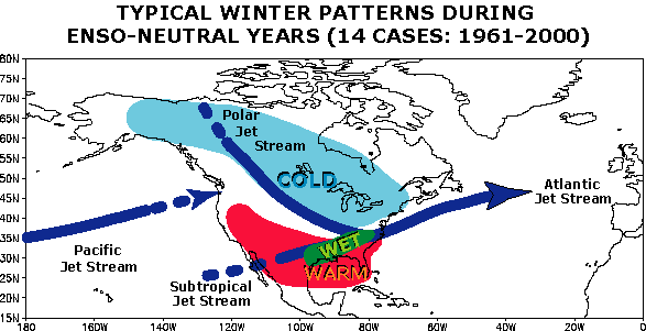
The above illustration shows a typical winter weather pattern associated with neutral years, or years with no significant El Nino or La Nina.� An active polar jet competes with the subtropical jet for dominance across the eastern U.S.� It reflects a pattern of the past season, dominated by frequent outbreaks of cool air from Canada, and ample wet weather across our region.
In the absence of either of the strong oceanic influences, most people are looking for a return to a more normal winter in this part of the country.� That means a considerably colder, snowier winter than either of the past two.� Of course, that would be true even if temperatures and snowfall are close to what is considered an average winter here.
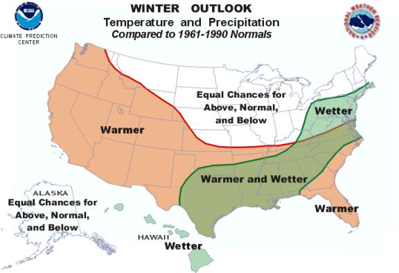
Above, a new long-range prediction map compares temperatures and precipitation to normals from 1961-1990.� Warmer than normal temperatures are expected from the Pacific Coast, east across the southern plains to the south Atlantic coast.� Across the northern U.S., temperatures are up for grabs, with the best bet being near normal.
Precipitation is predicted to be wetter than normal for our region.� This seems to indicate a fairly active winter for us, and certainly more typical of mid-latitude winters than we have experienced in the past two years.� For most people, even a normal winter will seem harsh in comparison to the past two mild winters we�ve had in central Pennsylvania.
What follows are some of the significant events NWS State College has documented since 1993.� With almost 34 years in the business, I�ve seen some pretty impressive weather, much of it in the past 7 years.� Pennsylvania gets an incredible amount of hazardous weather.� I�ve had enough!
Pond Bank Tornado
Franklin County � April 30, 1994
An F2 tornado destroyed this mobile home near Chambersburg.� Two occupants survived, but were seriously injured.� It was the first rotating thunderstorm tracked by the State College Doppler Radar.
Kantz Tornado
Snyder County � June 6, 1994
A tornado and downburst winds damaged 37 homes, 22 farm structures, and a Pepsi bottling plant southwest of Selinsgrove.� Damages totaled $2.5 million.

Millersville Tornado
Lancaster County � May 29, 1995
A small tornado lifted a tobacco shed off its foundation, and dropped it on a car.� The driver and her two children remarkably escaped injury when a beam fell down the middle of the vehicle.

Harrisburg, Dauphin County � January 12, 1996
Two major snowstorms in less than a week�s time piled snow up to 3 feet deep in Harrisburg and much of the rest of the state, setting the stage for the great January meltdown.

Photo by Suzanne Yenchko, 1996
January 19, 1996 Flood
Strong winds, warm temperatures, and rainfall of 1 to 3 inches combined to melt the deep snowpack and create the worst flooding since Hurricane Agnes.

Harrisburg Tornado � May 11, 1996
A small tornado touched down on the north side of Harrisburg on Cameron Street, damaging apartments and a factory.� This photo shows the wall cloud with the tornado obscured by the houses.
The same storms that rolled through Harrisburg continued east into Schuylkill County, taking down trees and damaging homes and mobile homes in Mary-D and Tuscarora, east of Pottsville.
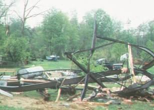
Mary-D Tornado
Schuylkill County � May 11, 1996
A mobile home in Mary-D was completely destroyed when a tree hit it lengthwise.
4-Wheel Drive Good for Snow, Not Tornadoes

Colver Tornado
Cambria County � July 19, 1996
The Colver tornado was the second of two tornadoes to cross Cambria County and one of nine to cross the state on the 19th of July, 1996.
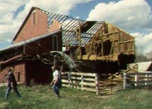
Table Rock Tornado, Near Biglerville
A small tornado took out a chicken coop, a number of trees, and pretty much cleaned out the above barn north of Gettysburg in early May of 1998.
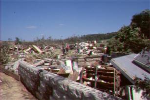
Somerset County � May 31, 1998
One of some 40 tornadoes to cross Pennsylvania in 3 days, from May 31 to June 2, 1998, this F3 tornado completely destroyed a barn and farmhouse in Pocahontas.� Just two days after the above storm struck Salisbury, another round hit the state.� Two more strong tornadoes crossed just north and east of Salisbury.� Another hit just south of Bradford, and one moved through Irish Valley near Shamokin.
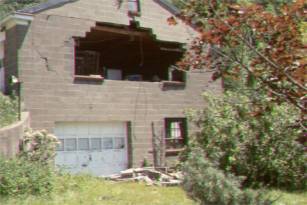
Custer Tornado, Near Bradford
The Custer tornado literally pulled the windows out of this west facing side of a concrete block garage.� Strong southerly winds flowing across the structure probably created the forces that sucked the windows and blocks out of the building.

Downburst, Near Garland
Warren County � July 9, 1999
This parked car, near Garland, was crushed by a tree as thunderstorms crossed the area.� A second tree fell nearby on another vehicle, killing one occupant and critically injuring two others.� Hundreds of trees were blown down across parts of Warren County with the storms.

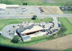
Peach Size Hail � Seven Valleys
York County � July 30, 1999
Hail collected from the Seven Valleys storm measured up to 2-1/2 inches and, except for the color, looked very much like the peaches grown in the area.

Photo from Tom Hess, EM Union Co.
Hurricane Dennis Comes to Lewisburg � September 7, 1999
Sunrise on September 7th brought the above scene in Lewisburg.� Water reached the tops of parking meters as cars floated down the streets.� Hundreds of homes were damaged, along with bridges, businesses, and Bucknell University.� Montgomery residents compared the flooding from Dennis to Agnes.� Rainfall amounts of 6 to nearly 8 inches fell overnight across the area.
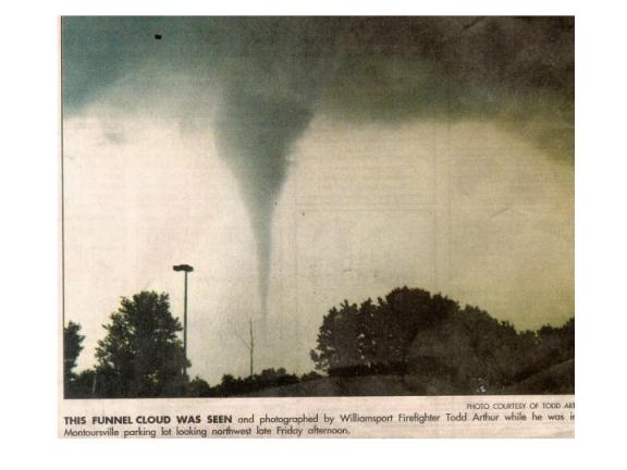
Farragut Tornado, Near Montoursville
Lycoming County � June 16, 2000
A volunteer fireman took this photo of a tornado that caused minor damage in Lycoming County.
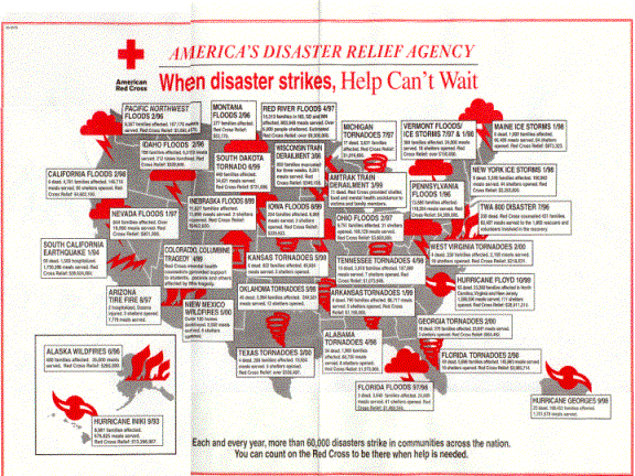
The disaster decade of the 90�s is shown above in the Red Cross Map of the country.� An apt national summary of events since we opened our doors in State College, and a fitting close to the disasters documented here, it�s also a great organization to remember with your donations.
Since 1993, our dedicated staff, along with state, county, and local emergency management, law enforcement and communications people, SKYWARN, and the Red Cross, have helped our state through some pretty impressive weather.
January 1, 2001, I take off my editor�s hat and lay down my analyst�s pencil.� Despite the world�s best technology, the job of forecasting the weather and warning for tornadoes and floods is a young man�s business, requiring split second decisions, a good memory, and maybe even nerves of steel.
I want to personally thank you all for helping us.� From early efforts to build our office into a modern forecast and warning center, through the worst floods since Agnes and the most damaging tornadoes since 1985, you made our warnings better.
Thanks for being part of our warning programs, and thanks for being so generous and friendly to me.� I�ll miss the SkyWarn training sessions and my journeys through some of the prettiest parts of Pennsylvania.� Best wishes to all; 73�s to the Hams.

Tom Dunham N2KBI


 Send Us a Report