Overview
|
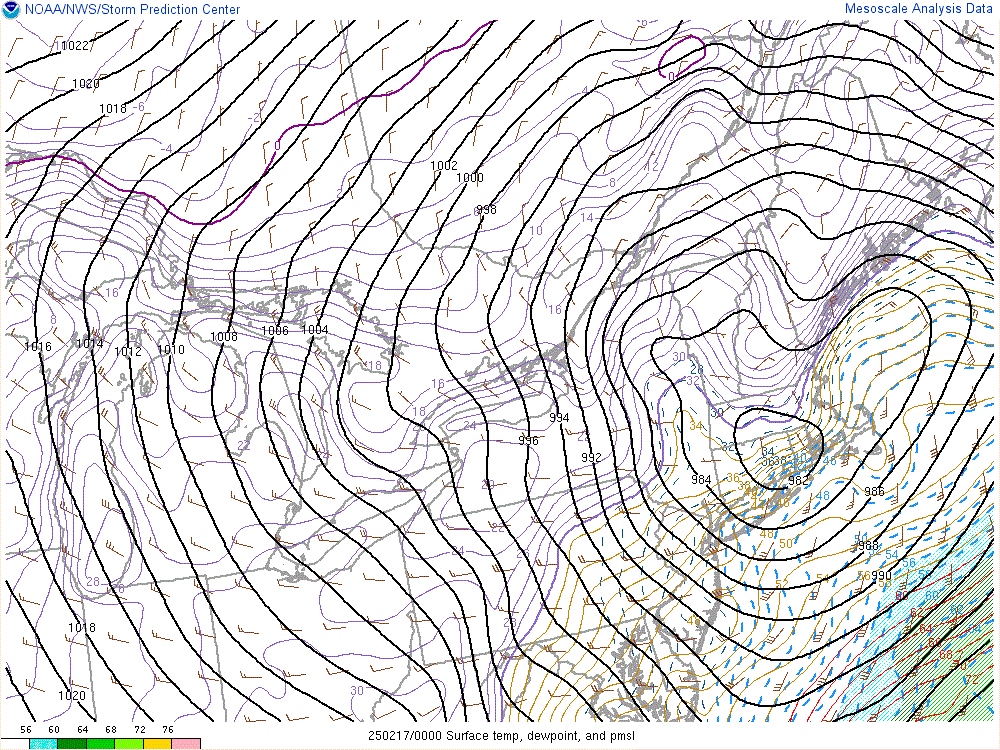
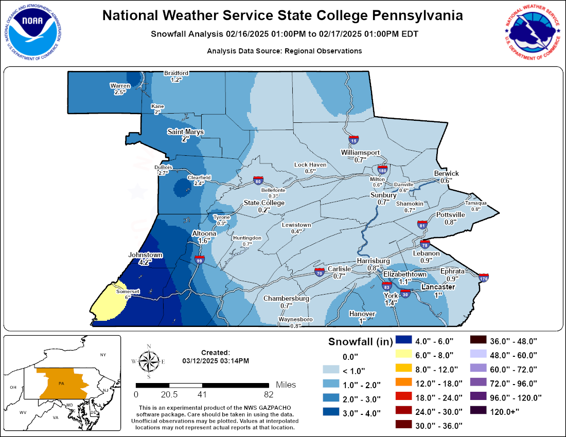
On the morning and afternoon of February 15th A digging upper trough over the east slopes of the Rockies spawned a strengthening surface low over the Southern Plains. Over time this low lifted northeast across the eastern Great Lakes from Saturday the 15th into Sunday afternoon of the 16th. As the center of low pressure propagated eastward, a lead shortwave and an associated plume of Pacific and Gulf moisture overran retreating cold air over PA, which provided ample moisture to spread snow across much of the forecast area by midday Saturday. The initial period of snow was followed by a transition to mixed precipitation during Saturday afternoon and evening. During this transition period, freezing rain and sleet fell on top of already present snow, and the combination of snow/sleet/ice made for hazardous travel conditions across all of central Pennsylvania. An eventual change to rain occurred Saturday night as the warm front lifted north into Pennsylvania, bringing the area into the warm sector under a southerly flow regime. On the backside of this system, a tight isallobaric couplet brought an additional hazard of non-thunderstorm wind gusts which warranted a high wind warning in anticipation of gusts greater than 58 mph. In total central Pennsylvania saw snow amounts between 0.5 inches across the east to near 6.0 inches in the Laurel highlands, ice amounts of between 0.01 inch to 0.40 inch across the area, and wind gusts reaching as high as 64 mph. |
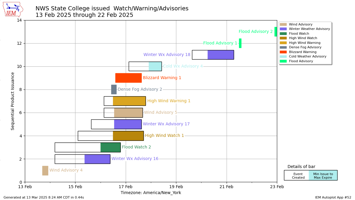 A timeline of watch/warning/advisory products issued by WFO CTP during this winter storm event. |
 |
 |
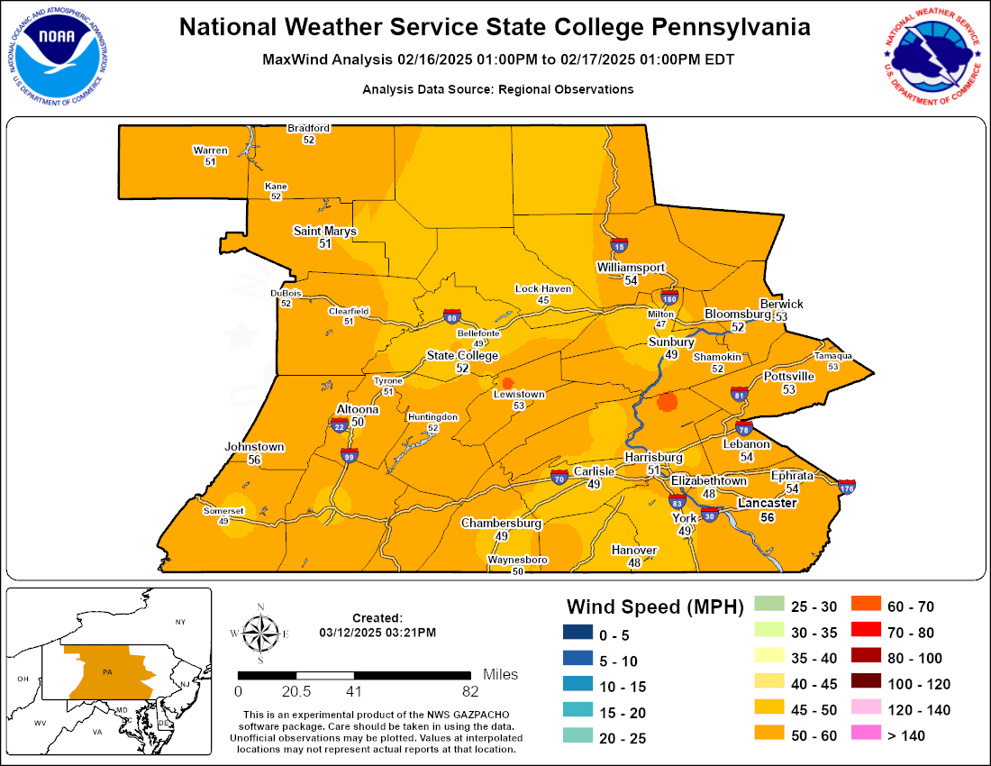 |
| SPC Mesoanalysis of surface temperature, dewpoints, winds, and mean sea level pressure valid 00z Feb 17, 2025 | CTP snowfall analysis valid from 1:00PM EST Feb 16, 2025 through 1:00PM EST Feb 17, 2025 | CTP high wind analysis valid from 1:00PM EST Feb 16, 2025 through 1:00PM EST Feb 17, 2025 |
Storm Reports
Public Information Statement
National Weather Service State College PA
1126 AM EST Mon Feb 17 2025

...HIGHEST WIND REPORTS...

Location                     Speed     Time/Date       Provider

...Pennsylvania...

...Adams County...
Cashtown 1 S                 51 MPH    0700 AM 02/17   COOP

...Bedford County...
Bedford Airport              47 MPH    0515 AM 02/17   AWOS

...Blair County...
Altoona-Blair County Airport 59 MPH    0502 PM 02/16   AWOS
Blair Helibase               48 MPH    0116 AM 02/17   RAWS

...Cambria County...
Johnstown Airport            58 MPH    0420 PM 02/16   ASOS
1 E Cresson                  50 MPH    1125 PM 02/16   PADOT

...Centre County...
PSU Beaver Stadium WxSTEM    55 MPH    0620 PM 02/16   MESOWEST
University Park Airport      49 MPH    1053 AM 02/17   AWOS
PSU Golf Course WxSTEM       47 MPH    0610 PM 02/16   MESOWEST
1 NE Port Matilda            47 MPH    0625 PM 02/16   PADOT
Zion                         45 MPH    0638 PM 02/16   CWOP

...Clearfield County...
Clearfield Airport           51 MPH    0559 PM 02/16   ASOS

...Clinton County...
Lock Haven Airport           45 MPH    0645 PM 02/16   AWOS
Coffin Rock                  45 MPH    1016 AM 02/17   RAWS

...Cumberland County...
6 SSE Bloserville            47 MPH    0725 AM 02/17   PADOT

...Dauphin County...
ELIZABETHVILLE               63 MPH    0714 PM 02/16   CWOP
Harrisburg                   56 MPH    0400 PM 02/16   MESOWEST
Harrisburg Intl Airport      53 MPH    0601 PM 02/16   ASOS
Hummelstown                  48 MPH    0706 PM 02/16   CWOP
Reach Cyber CharSch WxSTEM   45 MPH    0720 PM 02/16   MESOWEST

...Franklin County...
1 NNW Marion                 49 MPH    0625 PM 02/16   PADOT

...Fulton County...
2 S Crystal Springs          54 MPH    0945 PM 02/16   PADOT

...Juniata County...
3 S Alfarata                 57 MPH    0650 PM 02/16   PADOT

...Lancaster County...
Lancaster Airport            58 MPH    0740 PM 02/16   ASOS
Lititz                       58 MPH    0824 PM 02/16   ASOS
Manheim                      55 MPH    0745 PM 02/16   CWOP
1 E Rothsville               52 MPH    0641 PM 02/16   Public
Elizabethtown                48 MPH    0836 PM 02/16   CWOP

...Lebanon County...
2 ENE Harper Tavern          58 MPH    0630 PM 02/16   Trained Spotter
Muir Airfield Ft. Indiantown 53 MPH    0917 AM 02/17   AWOS

...Lycoming County...
Williamsport Airport         55 MPH    0123 AM 02/17   ASOS

...McKean County...
Bradford Airport             53 MPH    0307 AM 02/17   ASOS

...Mifflin County...
Mifflin County Airport-RVL   64 MPH    0355 AM 02/17   AWOS
Lewistown                    53 MPH    0411 PM 02/16   Dept of Highways
Chestnut Springs             46 MPH    0451 PM 02/16   RAWS

...Perry County...
Newport                      49 MPH    0651 PM 02/16   Dept of Highways
2 ENE Newport                49 MPH    0725 PM 02/16   PADOT

...Schuylkill County...
Joe Zerbey Airport           51 MPH    0735 PM 02/16   AWOS

...Snyder County...
Selinsgrove                  48 MPH    1047 PM 02/16   ASOS

...Somerset County...
Somerset                     52 MPH    0600 PM 02/16   CWOP
Ogletown                     52 MPH    0610 PM 02/16   PADOT
Somerset Airport             48 MPH    0355 PM 02/16   AWOS

...Union County...
LEWISBURG                    46 MPH    0322 AM 02/17   CWOP

...York County...
Capitol City Airport         49 MPH    0916 AM 02/17   ASOS
York Airport                 47 MPH    0429 PM 02/16   ASOS
Dover                        47 MPH    0445 PM 02/16   CWOP
&&
...SNOW/SLEET REPORTS IN THE PAST 24 HOURS...

Location                     Amount    Time/Date       Provider

...Pennsylvania...

...Adams County...
Cashtown                     2.2 in    0312 PM 02/15   Broadcast Media
Abbottstown                  1.5 in    1227 PM 02/15
New Oxford 0.8 SE            1.5 in    0730 AM 02/16   COCORAHS
Abbottstown 2.4 N            1.2 in    0800 AM 02/16   COCORAHS

...Bedford County...
2 SSE Osterburg              3.0 in    1200 PM 02/15   Public
Everett 3.4 SW               2.0 in    0658 AM 02/16   COCORAHS

...Blair County...
Tyrone 1.0 NNW               3.0 in    0700 AM 02/16   COCORAHS
Altoona 2                    2.0 in    0800 AM 02/16   COOP
3 N Ski Gap                  1.7 in    1200 PM 02/15   Public

...Cambria County...
Geistown                     3.5 in    0700 AM 02/16   COCORAHS

...Centre County...
Port Matilda 2.2 ESE         1.6 in    0700 AM 02/16   COCORAHS
Boalsburg 1.2 ENE            1.0 in    0700 AM 02/16   COCORAHS
State College                0.9 in    0700 AM 02/16   COOP
2 ENE State College          0.7 in    0243 PM 02/15   Trained Spotter
State College 1.3 SW         0.6 in    0700 AM 02/16   COCORAHS
Philipsburg                  0.5 in    0700 AM 02/16   COOP

...Clearfield County...
Grampian                     2.5 in    0600 AM 02/16   COOP

...Clinton County...
Renovo                       1.0 in    0700 AM 02/16   COOP

...Cumberland County...
4 SSW Colonel Denning State  2.2 in    0152 PM 02/15
Carlisle                     1.5 in    0700 AM 02/16   COOP
Carlisle 3.3 WSW             0.6 in    0700 AM 02/16   COCORAHS
Mechanicsburg 1.0 NNW        0.5 in    0742 AM 02/16   COCORAHS

...Dauphin County...
2 NNE Highspire              1.5 in    0216 PM 02/15
Middletown                   1.5 in    0500 PM 02/15   Official NWS Obs
Middletown 2.9 NW            1.5 in    0800 AM 02/16   COCORAHS
Hummelstown                  1.2 in    0220 PM 02/15   Broadcast Media
Hershey 2.1 NW               1.2 in    0740 AM 02/16   COCORAHS

...Elk County...
Ridgway                      1.0 in    0700 AM 02/16   COOP

...Franklin County...
Greencastle                  2.6 in    0615 PM 02/15   Trained Spotter
4 ESE Mercersburg            2.5 in    1200 PM 02/15   Trained Spotter
1 NNW Rouzerville            2.5 in    1226 PM 02/15
Upper Strasburg              2.0 in    0832 PM 02/15   Trained Spotter
2 WNW Rouzerville            1.8 in    1254 PM 02/15   Public
Waynesboro                   1.0 in    1223 PM 02/15

...Huntingdon County...
Huntingdon 1.3 N             1.8 in    0700 AM 02/16   COCORAHS

...Lancaster County...
3 NW New Holland             2.6 in    0330 PM 02/15   Public
Ephrata                      2.5 in    0245 PM 02/15   Trained Spotter
2 SW Manheim                 2.0 in    0231 PM 02/15
Maytown                      1.9 in    0220 PM 02/15
Bainbridge                   1.8 in    0405 PM 02/15   Public
Landisville 1.2 ESE          1.7 in    0700 AM 02/16   COCORAHS
1 E Lancaster                1.5 in    0238 PM 02/15
1 WSW Akron                  1.5 in    0257 PM 02/15
Lititz 0.3 WNW               1.5 in    0800 AM 02/16   COCORAHS
Millersville                 1.4 in    0752 PM 02/15   Trained Spotter

...Lebanon County...
Lebanon                      2.0 in    0234 PM 02/15   Trained Spotter
Lebanon 1.3 SW               1.2 in    0700 AM 02/16   COCORAHS
Lebanon 4.8 N                1.2 in    0700 AM 02/16   COCORAHS

...Lycoming County...
Montoursville                0.7 in    0500 PM 02/15   ASOS
Jersey Shore                 0.3 in    0315 PM 02/15   Public
Jersey Shore 0.7 WSW         0.2 in    0700 AM 02/16   COCORAHS

...Perry County...
Liverpool                    1.0 in    0200 PM 02/15   Amateur Radio
Newport                      0.8 in    0200 PM 02/15   Amateur Radio
New Bloomfield               0.7 in    0322 PM 02/15   Amateur Radio

...Potter County...
Roulette 1.8 NNE             1.5 in    0700 AM 02/16   COCORAHS
0.6 E Galeton                1.5 in    0800 AM 02/16   COOP

...Schuylkill County...
Tremont 0.3 NNW              1.2 in    0800 AM 02/16   COCORAHS
3 NE Tremont                 1.1 in    0302 PM 02/15
1.4 N Mahanoy City           0.9 in    0700 AM 02/16   COOP
Valley View 0.5 W            0.5 in    0600 AM 02/16   COCORAHS

...Somerset County...
Somerset                     5.2 in    0800 AM 02/16   COOP
1 NW Central City            5.0 in    1130 AM 02/15   Public
Friedens                     2.8 in    0200 PM 02/15   Public
Hidden Valley                2.5 in    0800 AM 02/16   COOP
Rockwood 4.3 W               2.0 in    0819 AM 02/16   COCORAHS
Laurel Summit                1.3 in    0700 AM 02/16   COOP

...Sullivan County...
Laporte                      2.5 in    0740 AM 02/16   COOP
Dushore                      1.3 in    0837 PM 02/15   Trained Spotter

...Tioga County...
Covington 2 WSW              2.5 in    0700 AM 02/16   COOP
Cowanesque Dam               2.5 in    0700 AM 02/16   COOP

...Union County...
Lewisburg                    0.5 in    0700 AM 02/16   COOP

...Warren County...
Russell 0.7 S                0.7 in    0800 AM 02/16   COCORAHS

...York County...
1 NNW Manchester             2.1 in    0318 PM 02/15
2 SW Spring Grove            2.0 in    0200 PM 02/15   Broadcast Media
1 SE New Salem               2.0 in    0324 PM 02/15   Trained Spotter
Mount Wolf 1.0 SE            2.0 in    0800 AM 02/16   COCORAHS
Dover 4.2 WSW                2.0 in    0850 AM 02/16   COCORAHS
2 NW Stonybrook              1.8 in    0200 PM 02/15   Emergency Mngr
Valley Green 0.8 ENE         1.7 in    0700 AM 02/16   COCORAHS
3 NW Emigsville              1.6 in    0145 PM 02/15   Trained Spotter
Glen Rock                    1.5 in    0120 PM 02/15   Public
East Berlin 3.4 ESE          1.5 in    0700 AM 02/16   COCORAHS
Loganville                   1.0 in    1251 PM 02/15   Trained Spotter
Hanover 1.3 SSE              1.0 in    0426 AM 02/16   COCORAHS
Mechanicsburg 6.9 SE         1.0 in    0700 AM 02/16   COCORAHS
Stewartstown 0.5 S           1.0 in    0746 AM 02/16   COCORAHS

...FREEZING RAIN REPORTS IN THE PAST 24 HOURS...

Location                     Amount    Time/Date       Provider

...Pennsylvania...

...Blair County...
Altoona-Blair County Airport 0.31 in   0903 AM 02/16   ASOS
1 SW Hollidaysburg           0.08 in   0913 PM 02/15   Public

...Cambria County...
Johnstown Airport            0.38 in   0854 AM 02/16   ASOS

...Centre County...
2 ESE Port Matilda           0.14 in   0834 AM 02/16   Public

...Clearfield County...
Clearfield Airport           0.42 in   0905 AM 02/16   ASOS

...Columbia County...
3 WNW Bloomsburg             0.15 in   0958 PM 02/15   Public

...Dauphin County...
Harrisburg Intl Airport       T in     0856 AM 02/16   ASOS

...Lancaster County...
3 NW New Holland              T in     0330 PM 02/15   Public

...Lycoming County...
Williamsport Airport         0.17 in   0854 AM 02/16   ASOS

...McKean County...
Bradford Airport             0.23 in   0753 AM 02/16   ASOS

...Schuylkill County...
1 NW Tamaqua                 0.10 in   1100 PM 02/15   Public

...Snyder County...
Selinsgrove                  0.05 in   0853 AM 02/16   ASOS

...York County...
Red Lion                     0.10 in   1018 PM 02/15   Public
Capitol City Airport         0.08 in   0856 AM 02/16   ASOS
York Airport                  T in     0905 AM 02/16   ASOS

&&
$$
 |
Media use of NWS Web News Stories is encouraged! Please acknowledge the NWS as the source of any news information accessed from this site. |
|


 Send Us a Report