Overview
| A progressive upper level shortwave trough brought a period of mixed wintry precipitation to central Pennsylvania during the early morning hours on February 6, 2025. Cold air damming east of the Allegheny Front to the south of a retreating 1030mb high pressure system was reinforced by evaporative cooling effects as precipitation expanded into a low dewpoint airmass. However, the air above the boundary layer did warm quickly, with a sharp nose of warm air advection within the 850-650mb layer. Some areas briefly saw snow, but the dominant precipitation types were sleet and freezing rain. Travel conditions were at their worst during the predawn hours and early morning commute. Snow and sleet accumulations ranged from a coating to 1 inch. Ice accretion of 0.20 to 0.40 inch was observed in portions of Cambria and Lancaster Counties. | 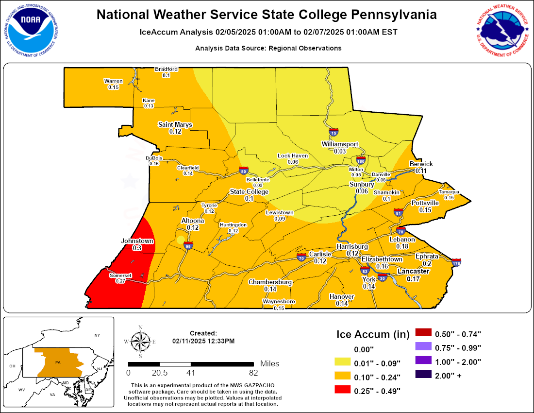 Analysis of ice accretion reports on Feb 6, 2025. |
 |
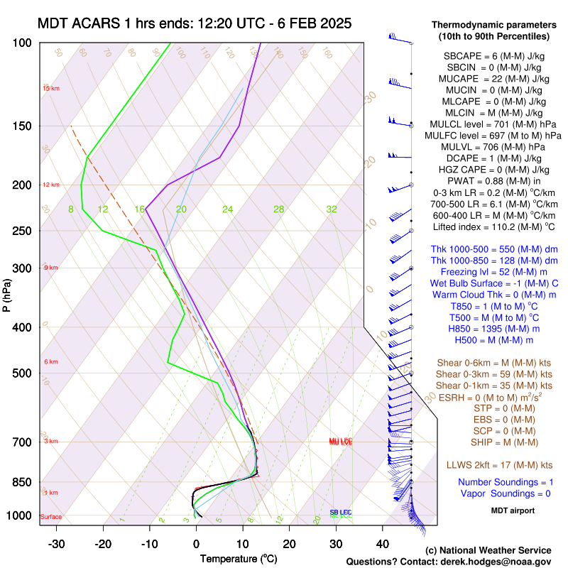 |
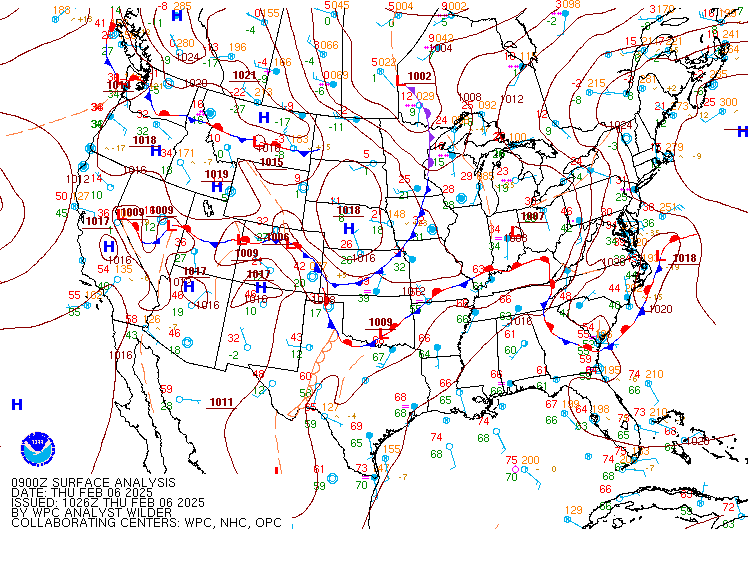
| WPC Surface Analysis valid 09z Feb 6, 2025. | ACARS sounding at Harrisburg International Airport at 1220z Feb 6, 2025. A mix of rain and sleet was observed at the time of the sounding. |
Storm Reports
Public Information Statement
National Weather Service State College PA
1227 PM EST Thu Feb 6 2025

...SNOWFALL/SLEET REPORTS FOR FEBRUARY 6, 2025...

Location                     Amount    Time/Date       Provider

...Pennsylvania...

...Adams County...
Biglerville                  1.0 in    0700 AM 02/06   COOP
Abbottstown 2.4 N            0.2 in    0800 AM 02/06   COCORAHS

...Bedford County...
Everett 3.4 SW               0.7 in    0646 AM 02/06   COCORAHS

...Blair County...
3 N Ski Gap                  0.9 in    0740 AM 02/06   Trained Spotter
Tyrone 1.0 NNW               0.2 in    0800 AM 02/06   COCORAHS
Tyrone                        T in     0647 AM 02/06   COOP
Williamsburg                  T in     0715 AM 02/06   COOP

...Centre County...
Port Matilda 2.2 ESE         0.5 in    0700 AM 02/06   COCORAHS
State College 1.3 SW         0.5 in    0700 AM 02/06   COCORAHS
Philipsburg                  0.4 in    0700 AM 02/06   COOP
State College                0.4 in    0700 AM 02/06   COOP
State College 2.4 ENE        0.4 in    0900 AM 02/06   COCORAHS

...Clearfield County...
Grampian                     1.0 in    0600 AM 02/06   COOP
DuBois 2.7 S                 0.6 in    0800 AM 02/06   COCORAHS

...Clinton County...
Renovo                       1.0 in    0700 AM 02/06   COOP
Mill Hall 1.6 N              0.3 in    0743 AM 02/06   COCORAHS

...Columbia County...
Orangeville                  0.3 in    0630 AM 02/06   Public

...Cumberland County...
Carlisle                      T in     0700 AM 02/06   COOP

...Dauphin County...
Dauphin 2.6 NNE              0.2 in    0800 AM 02/06   COCORAHS
Middletown 2.9 NW            0.2 in    0800 AM 02/06   COCORAHS
Hershey 2.1 NW                T in     0700 AM 02/06   COCORAHS

...Elk County...
Ridgway                      0.5 in    0700 AM 02/06   COOP

...Huntingdon County...
Huntingdon 1.3 N             0.5 in    0700 AM 02/06   COCORAHS
Tyrone 4.7 ENE               0.5 in    0700 AM 02/06   COCORAHS

...Lancaster County...
1 E Lancaster                0.3 in    0801 AM 02/06   Public
Lititz 0.3 WNW               0.2 in    0800 AM 02/06   COCORAHS
Ephrata 0.9 E                 T in     0730 AM 02/06   COCORAHS
Salunga-Landisville 1.1 SSE   T in     0900 AM 02/06   COCORAHS

...Lebanon County...
Palmyra 2.1 S                0.4 in    0700 AM 02/06   COCORAHS
Lebanon 1.3 SW               0.2 in    0700 AM 02/06   COCORAHS

...Lycoming County...
Williamsport 2.0 NE          0.5 in    0800 AM 02/06   COCORAHS
Jersey Shore 0.9 S           0.2 in    0700 AM 02/06   COCORAHS
Jersey Shore 0.7 WSW          T in     0700 AM 02/06   COCORAHS

...McKean County...
Bradford 5SW                 1.0 in    0800 AM 02/06   COOP
Kane                         0.5 in    0700 AM 02/06   COOP

...Mifflin County...
Lewistown                    0.2 in    0600 AM 02/06   COOP

...Perry County...
Liverpool                    0.5 in    0730 AM 02/06   Public

...Potter County...
5 NNE Denton Hill State Park 0.8 in    0800 AM 02/06   Trained Spotter
0.6 E Galeton                0.5 in    0800 AM 02/06   COOP
Roulette 1.8 NNE             0.5 in    0700 AM 02/06   COCORAHS

...Schuylkill County...
Valley View 0.5 W            0.5 in    0600 AM 02/06   COCORAHS
Tremont 0.3 NNW              0.4 in    0800 AM 02/06   COCORAHS

...Snyder County...
Selinsgrove 2.6 WNW          0.3 in    0730 AM 02/06   COCORAHS

...Somerset County...
Hidden Valley                0.2 in    0800 AM 02/06   COOP
Rockwood 4.3 W               0.2 in    0742 AM 02/06   COCORAHS
Somerset                      T in     0800 AM 02/06   COOP

...Sullivan County...
Laporte                       T in     0518 AM 02/06   COOP

...Union County...
Lewisburg                    0.2 in    0700 AM 02/06   COOP

...Warren County...
Russell 0.7 S                0.2 in    0800 AM 02/06   COCORAHS
Russell 4.7 W                 T in     0800 AM 02/06   COCORAHS

...York County...
Dover 4.2 WSW                0.7 in    0730 AM 02/06   COCORAHS
Mount Wolf 1.0 SE            0.2 in    0830 AM 02/06   COCORAHS
Valley Green 0.8 ENE         0.2 in    0700 AM 02/06   COCORAHS
York Haven 2.3 WNW            T in     0800 AM 02/06   COCORAHS

...FREEZING RAIN REPORTS FOR FEBRUARY 6, 2025...

Location                     Amount    Time/Date       Provider

...Pennsylvania...

...Blair County...
Altoona-Blair County Airport 0.17 in   1104 AM 02/06   AWOS
3 N Ski Gap                   T in     0740 AM 02/06   Trained Spotter

...Cambria County...
Johnstown Airport            0.38 in   1128 AM 02/06   ASOS
4 W Vinco                    0.35 in   1105 AM 02/06   Trained Spotter
1 SSE Geistown               0.25 in   1000 AM 02/06   Trained Spotter

...Centre County...
2 ESE Port Matilda           0.10 in   0800 AM 02/06   Trained Spotter

...Clearfield County...
Clearfield Airport           0.14 in   1102 AM 02/06   ASOS

...Columbia County...
Orangeville                  0.10 in   0630 AM 02/06   Public

...Dauphin County...
Harrisburg Intl Airport      0.17 in   1145 AM 02/06   ASOS

...Lancaster County...
Lancaster Airport            0.30 in   1120 AM 02/06   ASOS
4 E Wakefield                0.20 in   0451 AM 02/06   Public
1 E Lancaster                0.10 in   0809 AM 02/06   Public

...Lycoming County...
Williamsport Airport         0.01 in   1128 AM 02/06   ASOS

...McKean County...
Bradford Airport             0.09 in   1141 AM 02/06   ASOS

...Snyder County...
Selinsgrove                  0.03 in   1125 AM 02/06   ASOS

...York County...
York Airport                 0.16 in   1138 AM 02/06   ASOS
Capitol City Airport         0.11 in   1056 AM 02/06   ASOS
Red Lion                     0.10 in   0526 AM 02/06   Public
&&

**METADATA**
:2/06/2025,0800 AM, PA, Adams, Abbottstown 2.4 N, , , 39.9192, -76.9894, SNOW_24, 0.2, Inch, COCORAHS, 24 hour snowfall,
:2/06/2025,0700 AM, PA, Adams, Biglerville, , , 39.9347, -77.2546, SNOW_24, 1, Inch, COOP, 24 hour snowfall,
:2/06/2025,0646 AM, PA, Bedford, Everett 3.4 SW, , , 39.9757, -78.4087, SNOW_24, 0.7, Inch, COCORAHS, 24 hour snowfall,
:2/06/2025,0740 AM, PA, Blair, 3 N Ski Gap, , , 40.3632901, -78.5154676, FREEZING_RAIN, 0.001, Inch, Trained Spotter, Storm total freezing rain,
:2/06/2025,0647 AM, PA, Blair, Tyrone, , , 40.6667, -78.2333, SNOW_24, 0.001, Inch, COOP, 24 hour snowfall,
:2/06/2025,0715 AM, PA, Blair, Williamsburg, , , 40.4667, -78.2, SNOW_24, 0.001, Inch, COOP, 24 hour snowfall,
:2/06/2025,1104 AM, PA, Blair, Altoona-Blair County Airport, , , 40.2999, -78.3168, FREEZING_RAIN_24, 0.17, Inch, AWOS, 24 hour freezing rain,
:2/06/2025,0800 AM, PA, Blair, Tyrone 1.0 NNW, , , 40.6901, -78.2541, SNOW_24, 0.2, Inch, COCORAHS, 24 hour snowfall,
:2/06/2025,0740 AM, PA, Blair, 3 N Ski Gap, , , 40.3632901, -78.5154676, SNOW_24, 0.9, Inch, Trained Spotter, 24 hour snowfall,
:2/06/2025,1000 AM, PA, Cambria, 1 SSE Geistown, , , 40.27686, -78.86639, FREEZING_RAIN, 0.25, Inch, Trained Spotter, Storm total freezing rain,
:2/06/2025,1105 AM, PA, Cambria, 4 W Vinco, , , 40.41271, -78.91879, FREEZING_RAIN, 0.35, Inch, Trained Spotter, Storm total freezing rain,
:2/06/2025,1128 AM, PA, Cambria, Johnstown Airport, , , 40.3167, -78.8333, FREEZING_RAIN_24, 0.38, Inch, ASOS, 24 hour freezing rain,
:2/06/2025,0800 AM, PA, Centre, 2 ESE Port Matilda, , , 40.790888, -78.0159489, FREEZING_RAIN, 0.1, Inch, Trained Spotter, Storm total freezing rain,
:2/06/2025,0700 AM, PA, Centre, Philipsburg, , , 40.8722, -78.2153, SNOW_24, 0.4, Inch, COOP, 24 hour snowfall,
:2/06/2025,0700 AM, PA, Centre, State College, , , 40.7935, -77.8672, SNOW_24, 0.4, Inch, COOP, 24 hour snowfall,
:2/06/2025,0900 AM, PA, Centre, State College 2.4 ENE, , , 40.8067, -77.8167, SNOW_24, 0.4, Inch, COCORAHS, 24 hour snowfall,
:2/06/2025,0700 AM, PA, Centre, Port Matilda 2.2 ESE, , , 40.7912, -78.0118, SNOW_24, 0.5, Inch, COCORAHS, 24 hour snowfall,
:2/06/2025,0700 AM, PA, Centre, State College 1.3 SW, , , 40.7801, -77.8783, SNOW_24, 0.5, Inch, COCORAHS, 24 hour snowfall,
:2/06/2025,1102 AM, PA, Clearfield, Clearfield Airport, , , 41.05, -78.4167, FREEZING_RAIN_24, 0.14, Inch, ASOS, 24 hour freezing rain,
:2/06/2025,0800 AM, PA, Clearfield, DuBois 2.7 S, , , 41.0842, -78.7467, SNOW_24, 0.6, Inch, COCORAHS, 24 hour snowfall,
:2/06/2025,0600 AM, PA, Clearfield, Grampian, , , 40.9666, -78.5871, SNOW_24, 1, Inch, COOP, 24 hour snowfall,
:2/06/2025,0743 AM, PA, Clinton, Mill Hall 1.6 N, , , 41.1276, -77.4854, SNOW_24, 0.3, Inch, COCORAHS, 24 hour snowfall,
:2/06/2025,0700 AM, PA, Clinton, Renovo, , , 41.3333, -77.7333, SNOW_24, 1, Inch, COOP, 24 hour snowfall,
:2/06/2025,0630 AM, PA, Columbia, Orangeville, , , 41.0766, -76.4131, FREEZING_RAIN, 0.1, Inch, Public, Storm total freezing rain,
:2/06/2025,0630 AM, PA, Columbia, Orangeville, , , 41.0766, -76.4131, SNOW_24, 0.3, Inch, Public, 24 hour snowfall,
:2/06/2025,0700 AM, PA, Cumberland, Carlisle, , , 40.2258, -77.1894, SNOW_24, 0.001, Inch, COOP, 24 hour snowfall,
:2/06/2025,0700 AM, PA, Dauphin, Hershey 2.1 NW, , , 40.3022, -76.6745, SNOW_24, 0.001, Inch, COCORAHS, 24 hour snowfall,
:2/06/2025,1145 AM, PA, Dauphin, Harrisburg Intl Airport, , , 40.2, -76.7667, FREEZING_RAIN_24, 0.17, Inch, ASOS, 24 hour freezing rain,
:2/06/2025,0800 AM, PA, Dauphin, Dauphin 2.6 NNE, , , 40.405, -76.9149, SNOW_24, 0.2, Inch, COCORAHS, 24 hour snowfall,
:2/06/2025,0800 AM, PA, Dauphin, Middletown 2.9 NW, , , 40.2349, -76.7617, SNOW_24, 0.2, Inch, COCORAHS, 24 hour snowfall,
:2/06/2025,0700 AM, PA, Elk, Ridgway, , , 41.4167, -78.75, SNOW_24, 0.5, Inch, COOP, 24 hour snowfall,
:2/06/2025,0700 AM, PA, Huntingdon, Huntingdon 1.3 N, , , 40.5152, -78.0151, SNOW_24, 0.5, Inch, COCORAHS, 24 hour snowfall,
:2/06/2025,0700 AM, PA, Huntingdon, Tyrone 4.7 ENE, , , 40.6946, -78.1592, SNOW_24, 0.5, Inch, COCORAHS, 24 hour snowfall,
:2/06/2025,0730 AM, PA, Lancaster, Ephrata 0.9 E, , , 40.1829, -76.167, SNOW_24, 0.001, Inch, COCORAHS, 24 hour snowfall,
:2/06/2025,0900 AM, PA, Lancaster, Salunga-Landisville 1.1 SSE, , , 40.077, -76.4117, SNOW_24, 0.001, Inch, COCORAHS, 24 hour snowfall,
:2/06/2025,0809 AM, PA, Lancaster, 1 E Lancaster, , , 40.0422, -76.2818, FREEZING_RAIN, 0.10, Inch, Public, Storm total freezing rain,
:2/06/2025,0451 AM, PA, Lancaster, 4 E Wakefield, , , 39.7577, -76.0999, FREEZING_RAIN, 0.20, Inch, Public, Storm total freezing rain,
:2/06/2025,0800 AM, PA, Lancaster, Lititz 0.3 WNW, , , 40.1556, -76.3095, SNOW_24, 0.2, Inch, COCORAHS, 24 hour snowfall,
:2/06/2025,0801 AM, PA, Lancaster, 1 E Lancaster, , , 40.0422, -76.2818, SNOW_24, 0.3, Inch, Public, 24 hour snowfall,
:2/06/2025,1120 AM, PA, Lancaster, Lancaster Airport, , , 40.1167, -76.3, FREEZING_RAIN_24, 0.3, Inch, ASOS, 24 hour freezing rain,
:2/06/2025,0700 AM, PA, Lebanon, Lebanon 1.3 SW, , , 40.3297, -76.4416, SNOW_24, 0.2, Inch, COCORAHS, 24 hour snowfall,
:2/06/2025,0700 AM, PA, Lebanon, Palmyra 2.1 S, , , 40.2798, -76.5992, SNOW_24, 0.4, Inch, COCORAHS, 24 hour snowfall,
:2/06/2025,0700 AM, PA, Lycoming, Jersey Shore 0.7 WSW, , , 41.1954, -77.2792, SNOW_24, 0.001, Inch, COCORAHS, 24 hour snowfall,
:2/06/2025,1128 AM, PA, Lycoming, Williamsport Airport, , , 41.25, -76.9167, FREEZING_RAIN_24, 0.01, Inch, ASOS, 24 hour freezing rain,
:2/06/2025,0700 AM, PA, Lycoming, Jersey Shore 0.9 S, , , 41.1871, -77.2657, SNOW_24, 0.2, Inch, COCORAHS, 24 hour snowfall,
:2/06/2025,0800 AM, PA, Lycoming, Williamsport 2.0 NE, , , 41.2571, -77.0085, SNOW_24, 0.5, Inch, COCORAHS, 24 hour snowfall,
:2/06/2025,1141 AM, PA, McKean, Bradford Airport, , , 41.8, -78.6333, FREEZING_RAIN_24, 0.09, Inch, ASOS, 24 hour freezing rain,
:2/06/2025,0700 AM, PA, McKean, Kane, , , 41.6833, -78.8, SNOW_24, 0.5, Inch, COOP, 24 hour snowfall,
:2/06/2025,0800 AM, PA, McKean, Bradford 5SW, , , 41.898, -78.7143, SNOW_24, 1, Inch, COOP, 24 hour snowfall,
:2/06/2025,0600 AM, PA, Mifflin, Lewistown, , , 40.5833, -77.5667, SNOW_24, 0.2, Inch, COOP, 24 hour snowfall,
:2/06/2025,0730 AM, PA, Perry, Liverpool, , , 40.5724, -76.9928, SNOW_24, 0.5, Inch, Public, 24 hour snowfall,
:2/06/2025,0800 AM, PA, Potter, 0.6 E Galeton, , , 41.7333, -77.6333, SNOW_24, 0.5, Inch, COOP, 24 hour snowfall,
:2/06/2025,0700 AM, PA, Potter, Roulette 1.8 NNE, , , 41.8076, -78.1414, SNOW_24, 0.5, Inch, COCORAHS, 24 hour snowfall,
:2/06/2025,0800 AM, PA, Potter, 5 NNE Denton Hill State Park, , , 41.8285, -77.7985, SNOW_24, 0.75, Inch, Trained Spotter, 24 hour snowfall,
:2/06/2025,0800 AM, PA, Schuylkill, Tremont 0.3 NNW, , , 40.6338, -76.3937, SNOW_24, 0.4, Inch, COCORAHS, 24 hour snowfall,
:2/06/2025,0600 AM, PA, Schuylkill, Valley View 0.5 W, , , 40.6437, -76.5485, SNOW_24, 0.5, Inch, COCORAHS, 24 hour snowfall,
:2/06/2025,1125 AM, PA, Snyder, Selinsgrove, , , 40.8167, -76.8667, FREEZING_RAIN_24, 0.03, Inch, ASOS, 24 hour freezing rain,
:2/06/2025,0730 AM, PA, Snyder, Selinsgrove 2.6 WNW, , , 40.8173, -76.9097, SNOW_24, 0.3, Inch, COCORAHS, 24 hour snowfall,
:2/06/2025,0800 AM, PA, Somerset, Somerset, , , 40, -79.0833, SNOW_24, 0.001, Inch, COOP, 24 hour snowfall,
:2/06/2025,0800 AM, PA, Somerset, Hidden Valley, , , 40.042, -79.2566, SNOW_24, 0.2, Inch, COOP, 24 hour snowfall,
:2/06/2025,0742 AM, PA, Somerset, Rockwood 4.3 W, , , 39.9215, -79.2377, SNOW_24, 0.2, Inch, COCORAHS, 24 hour snowfall,
:2/06/2025,0518 AM, PA, Sullivan, Laporte, , , 41.4247, -76.4925, SNOW_24, 0.001, Inch, COOP, 24 hour snowfall,
:2/06/2025,0700 AM, PA, Union, Lewisburg, , , 40.9486, -76.8783, SNOW_24, 0.2, Inch, COOP, 24 hour snowfall,
:2/06/2025,0800 AM, PA, Warren, Russell 4.7 W, , , 41.942, -79.0494, SNOW_24, 0.001, Inch, COCORAHS, 24 hour snowfall,
:2/06/2025,0800 AM, PA, Warren, Russell 0.7 S, , , 41.9313, -79.138, SNOW_24, 0.2, Inch, COCORAHS, 24 hour snowfall,
:2/06/2025,0800 AM, PA, York, York Haven 2.3 WNW, , , 40.1184, -76.7581, SNOW_24, 0.001, Inch, COCORAHS, 24 hour snowfall,
:2/06/2025,0526 AM, PA, York, Red Lion, , , 39.901, -76.606, FREEZING_RAIN, 0.10, Inch, Public, Storm total freezing rain,
:2/06/2025,1056 AM, PA, York, Capitol City Airport, , , 40.2167, -76.85, FREEZING_RAIN_24, 0.11, Inch, ASOS, 24 hour freezing rain,
:2/06/2025,1138 AM, PA, York, York Airport, , , 39.9167, -76.8833, FREEZING_RAIN_24, 0.16, Inch, ASOS, 24 hour freezing rain,
:2/06/2025,0830 AM, PA, York, Mount Wolf 1.0 SE, , , 40.0488, -76.6948, SNOW_24, 0.2, Inch, COCORAHS, 24 hour snowfall,
:2/06/2025,0700 AM, PA, York, Valley Green 0.8 ENE, , , 40.1612, -76.7791, SNOW_24, 0.2, Inch, COCORAHS, 24 hour snowfall,
:2/06/2025,0730 AM, PA, York, Dover 4.2 WSW, , , 39.9734, -76.9178, SNOW_24, 0.7, Inch, COCORAHS, 24 hour snowfall,

Observations are collected from a variety of sources with varying
equipment and exposures. We thank all volunteer weather observers
for their dedication. Not all data listed are considered official.

$$
NPB/MRS
 |
Media use of NWS Web News Stories is encouraged! Please acknowledge the NWS as the source of any news information accessed from this site. |
|


 Send Us a Report