
Showers and thunderstorms will continue along and ahead of a cold front for the eastern third of the country. The rainfall for the Great Lakes region could prolong the ongoing flooding. Much cooler weather will filter in behind this cold front along and east of the Rockies. Where the rain is needed, the Southern High Plains, critical fire weather concerns through this weekend. Read More >
Overview
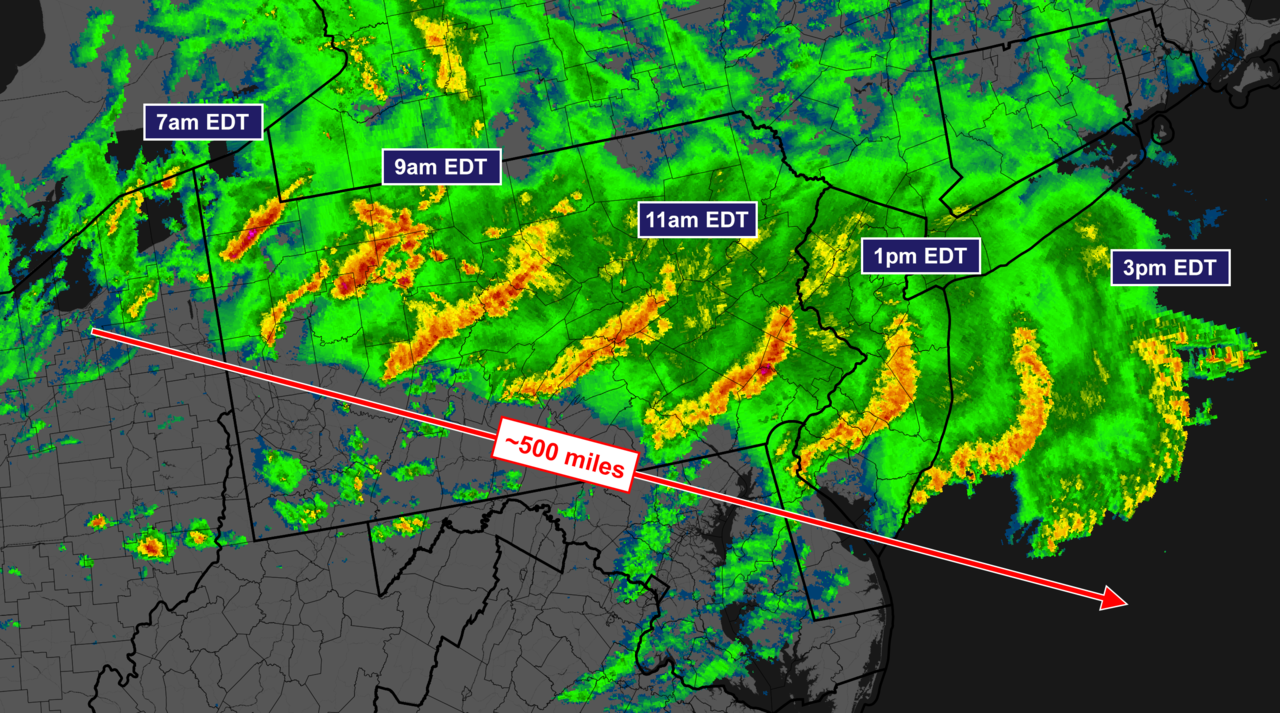
On the morning of June 3, 2020, a Mesoscale Convective System developed just south of Lake Erie. Later that morning the squall line made its way across PA and was met with an area of increasingly unstable air. This development led to even stronger damaging winds and over 250 reports of wind damage, enabling the storm to be classified as a derecho. Unfortunately, this event claimed 4 lives and left 575,000 people without power.
 |
 |
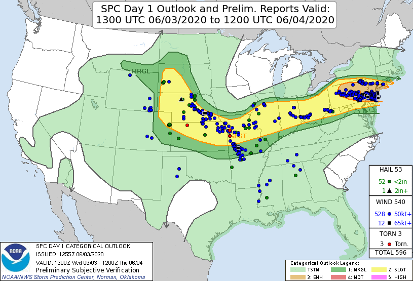 |
| Radar Mosaic of Derecho 7am EDT - 3pm EDT | Downed tree branch and damaged power lines caused by the derecho in Hatboro, PA | SPC Outlook & Confirmed Reports |
Area Forecast Discussion
Area Forecast Discussion
578
FXUS61 KCTP 030858
AFDCTP
Area Forecast Discussion
National Weather Service State College PA
458 AM EDT Wed Jun 3 2020
.SYNOPSIS...
Potentially strong thunderstorms are expected today and into
the evening as a frontal boundary slides southward through the
state. It will remain unsettled Thursday into Friday, and
possibly right into the weekend. High pressure and dry air take
hold Sunday and lasts into Tuesday.
&&
.NEAR TERM /UNTIL 6 PM THIS EVENING/...
Earlier strong/severe storms have dropped into the lower Susq
valley and continue southward. While they have weakened, some of
the cells are still potent. They continue to move into less-
favorable air, esp at the sfc. This convection seems to be more
aloft than sfc-based. They should continue to weaken.
Eyes turn to the large storms moving over LE from Lower ONT.
These are on track to reach Warren Co around 6 AM. Will see what
the lake water/temps and dewpoints do to them. This convection
is a little faster than what model solutions have going. This
would have repercussions on the going fcst, perhaps resulting
in the storms being less potent if the heating of the day does
not have as much time to occur before the storms reach the
NC/NErn counties. However, the latest HRRR does develop a new
batch of storms back to the west of this stuff, and moves it
across in the current timing of the forecast. This is in line
with the most notable short wave trough we see in this fast WNW
flow. So, will hold the line for the time being on all timing,
but add in the mention of stronger storms arriving a little
quicker in the NW.
Storm attributes/mode appear to be supercellular at first, but
then would morph into clusters/bowing segments. Bulk shear is
50-60kts with the mid-levels holding 60kt westerly winds which,
on a uni-direction shear day like today, will efficiently mix
down and producing long-lived bow echoes. Lingering boundaries
from overnight convection will make plenty of places to generate
storms. The early-day timing across the north is a slight
detriment to severe potential.
Some sunshine and heating is expected in the SW, and the main
boundary for storms to focus upon will create locations in the
central and SWrn counties for development this aftn. The
coverage over the Lower Susq and S-Central mtns is expected to
be lower, but the atmos is still potent there. There may be
CAPEs in the 2000 range in the SE, but high cloud coverage from
upstream convection could knock that down. Shear is also around
40KTs there, lower than inn the north. It is only a couple of
times a year that Central PA is placed into a ENH risk, so we
need to be attentive to any cells that develop.
Temps will be a function of the clearing we get and how early
the storms occur in the north. Maxes should get into the 80s in
the south, but only the lower 70s along the NY border. Wind will
probably be gusting into the 20s over the SW/SC before the
storms flare up there.
&&
.SHORT TERM /6 PM THIS EVENING THROUGH 6 PM THURSDAY/...
Storms should still be going early this evening in the southern
third of the area, but clearing should be starting across the
north. This clearing may self-destruct and turn to some fog, but
if the clearing occurs earlier in the aftn, it could dry out
well enough to keep fog patchy. Low clouds are also possible
where the wind is an upslope (Alleghenies). Storms/showers will
diminish for everyone but the SW around or shortly after
midnight. Sticky air will keep the temps from falling out of the
mid 60s for about half of the area. With some clearing, the nrn
mtns could get into the 50s.
The old boundary will likely be along the srn border Thurs
morning, the sfc wind will be light and SWrly. Upper flow
flattens to a W-E direction, and lingering moisture and daytime
heat will lead to showers and storms in the aftn. The shear will
be lacking, but CAPEs could reach 1000 or better across the
south. So, a few of the storms could go severe, but most likely,
without the shear, many will be sub-severe. SPC MRGL risk is
enough to keep a close eye on them. Maxes Thurs will be just as
warm across the north than the south, thanks to more sun up
north. The coolest place will be the Laurels where clouds and a
higher chc of showers exist.
&&
.LONG TERM /THURSDAY NIGHT THROUGH TUESDAY/...
The old front will stall near the PA-MD border on Thu, keeping
a chance of rain showers and maybe a few PM tstms through Fri.
Generally a quarter to half an inch of rain is expected across
the southern counties Thu-Fri, with locally higher amounts in
storms. Lesser amounts north.
The stationary front is progged to move offshore Fri night, with
slightly drier air moving in for Sat. Another cold front and
shortwave trough may touch off isolated showers/storms Sat, but
drier air will be a limiting factor. Cooler, drier air will move
in behind this front for Sun-Mon. We will see a warming trend
into the middle of next week as the remnants of TS Cristobal
moving up the MS valley help build an upper ridge over the
eastern US.
&&
.AVIATION /08Z WEDNESDAY THROUGH SUNDAY/...
Multiple rounds of showers and t-storms will move across parts
of the airspace from early this morning through early tonight.
Confidence in exact timing/details is still somewhat uncertain,
but the general storm evolution seemed to be handled reasonably
well by the hires models. The first cluster of storms will
continue to slide southeast and impact airfields near and east
of a line from KOYM/KUNV/KMDT. The second round of storms should
be associated with t-storm complex currently moving across srn
MI which is fcst to translate downstream through srn Ontario and
across Lake Erie later this morning. Model guidance tracks this
feature which /may be accompanied by severe wind gusts/ east-
southeast across north central PA into eastern PA btwn 13-19Z.
The third and final round of t-storms should form along a
southeastward advancing cold front and impact the south central
airspace later this afternoon into early tonight. Outside of
t-storms, expect mainly VFR conditions to prevail during the
03/06Z TAF period.
Outlook...
Thu...Showers/t-storms likely especially srn 1/2.
Fri-Sat...Chance of showers/t-storms.
Sun...VFR/no sig wx.
&&
.CTP WATCHES/WARNINGS/ADVISORIES...
None.
&&
$$
SYNOPSIS...Dangelo/Evanego
NEAR TERM...Dangelo
SHORT TERM...Dangelo/Evanego
LONG TERM...Gartner/Colbert
AVIATION...Steinbugl
Storm Reports
523
NOUS41 KPHI 031851
PNSPHI
DEZ001>004-MDZ008-012-015-019-020-NJZ001-007>010-012>027-PAZ054-055-060>062-
070-071-101>106-040651-
Public Information Statement
National Weather Service Mount Holly NJ
251 PM EDT Wed Jun 3 2020
...HIGHEST THUNDERSTORM WIND GUST REPORTS...
Location Speed Time/Date Provider
...New Jersey...
...Burlington County...
2 SE Jacksonville 67 MPH 1240 PM 06/03 Mesonet
1 NW Rancocas 65 MPH 1230 PM 06/03 NWS Employee
2 SW Rancocas 65 MPH 1235 PM 06/03 Mesonet
1 ESE Lumberton Twp 61 MPH 1240 PM 06/03 Mesonet
1 SE Lumberton 60 MPH 1240 PM 06/03 Trained Spotter
...Camden County...
1 SSW Palmyra 59 MPH 1230 PM 06/03 Mesonet
...Mercer County...
Trenton Mercer Airport (KTTN 58 MPH 1232 PM 06/03 ASOS
...Monmouth County...
1 ESE Brielle 76 MPH 0114 PM 06/03 Public
...Ocean County...
2 SW Beach Haven 89 MPH 0115 PM 06/03 Mesonet
Brick 87 MPH 0114 PM 06/03 Mesonet
Harvey Cedars 70 MPH 0115 PM 06/03 Mesonet
4 SE Mystic Island 68 MPH 0118 PM 06/03 Mesonet
5 SE Mystic Island 68 MPH 0118 PM 06/03 Mesonet
Berkeley Twp 67 MPH 0105 PM 06/03 Mesonet
Lakehurst Maxfield Field Air 66 MPH 1258 PM 06/03 AWOS
4 SE Mystic Island 66 MPH 0110 PM 06/03 Mesonet
Seaside Park 63 MPH 0108 PM 06/03 Mesonet
2 SSW Seaside Park 63 MPH 0115 PM 06/03 Public
3 W Jackson 59 MPH 0100 PM 06/03 Mesonet
Ocean County Airport (KMJX) 59 MPH 0102 PM 06/03 AWOS
1 ENE Lanoka Harbor 59 MPH 0112 PM 06/03 Mesonet
1 NNE Surf City 59 MPH 0115 PM 06/03 Public
...Pennsylvania...
...Berks County...
Reading Regional Airport (KR 83 MPH 1135 AM 06/03 ASOS
Reading Regional Airport (KR 67 MPH 1134 AM 06/03 ASOS
1 SSW Ruscombmanor Twp 60 MPH 1145 AM 06/03 Mesonet
...Bucks County...
1 SSW Bristol 64 MPH 1230 PM 06/03 Mesonet
...Chester County...
Malvern 75 MPH 1215 PM 06/03 Public
North Coventry Twp 67 MPH 1156 AM 06/03 Trained Spotter
...Delaware County...
1 W Philadelphia Intl 59 MPH 1229 PM 06/03 Other Federal
...Montgomery County...
Pottstown 76 MPH 1159 AM 06/03 Trained Spotter
1 SSE Fort Washington 66 MPH 1225 PM 06/03 Mesonet
...Philadelphia County...
1 E Holmesburg 71 MPH 1230 PM 06/03 Mesonet
Northeast Philadelphia Airpo 68 MPH 1225 PM 06/03 ASOS
Philadelphia International A 61 MPH 1228 PM 06/03 ASOS
...New Jersey...
...Maritime Stations...
2 E Waretown 72 MPH 0113 PM 06/03 Mesonet
1 E Barnegat Light 69 MPH 0114 PM 06/03 Mesonet
2 WSW Ship Bottom 68 MPH 0115 PM 06/03 Mesonet
2 SSW Seaside Park 66 MPH 0113 PM 06/03 Mesonet
Barnegat Light 60 MPH 0118 PM 06/03 Mesonet
&&
Environment
Upper-level maps
 |
 |
| 250-mb Analysis 6/3/20 12Z | 500-mb Analysis 6/3/20 12Z |
Surface Maps
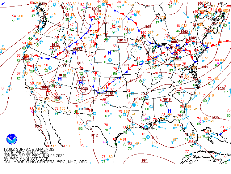 |
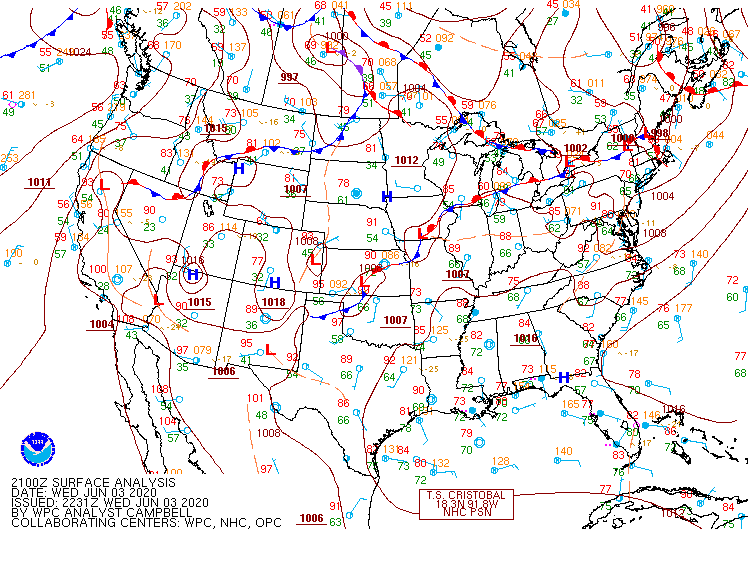 |
| Surface Map 6/3/20 12Z | Surface Map 6/3/20 21Z |
Sounding Data
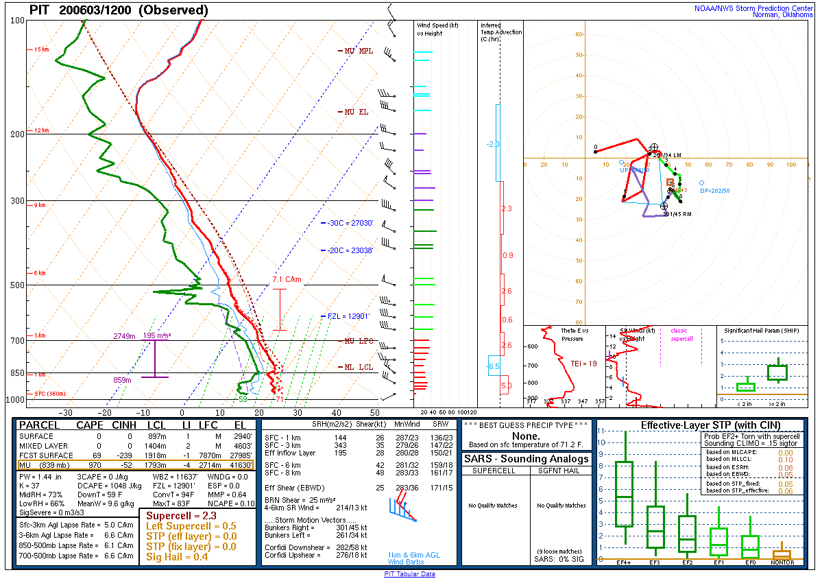 |
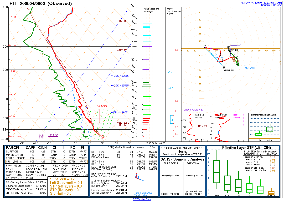 |
| 12Z Pittsburgh, PA Sounding | 0Z PIttsburgh, PA Sounding |
SPC Data
 |
|
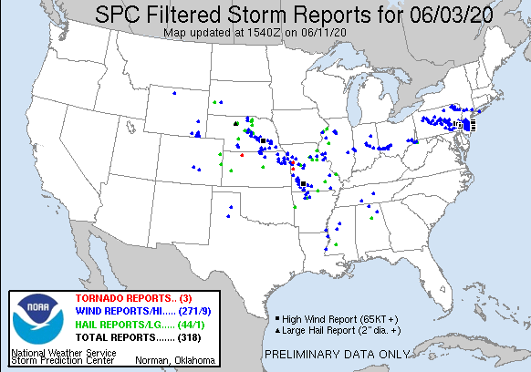
| SPC Filtered Reports for 06/30/2020 | SPC Day 1 Outlook and Preliminary Reports 06/30/2020 |
 |
Media use of NWS Web News Stories is encouraged! Please acknowledge the NWS as the source of any news information accessed from this site. |
|


 Send Us a Report