|
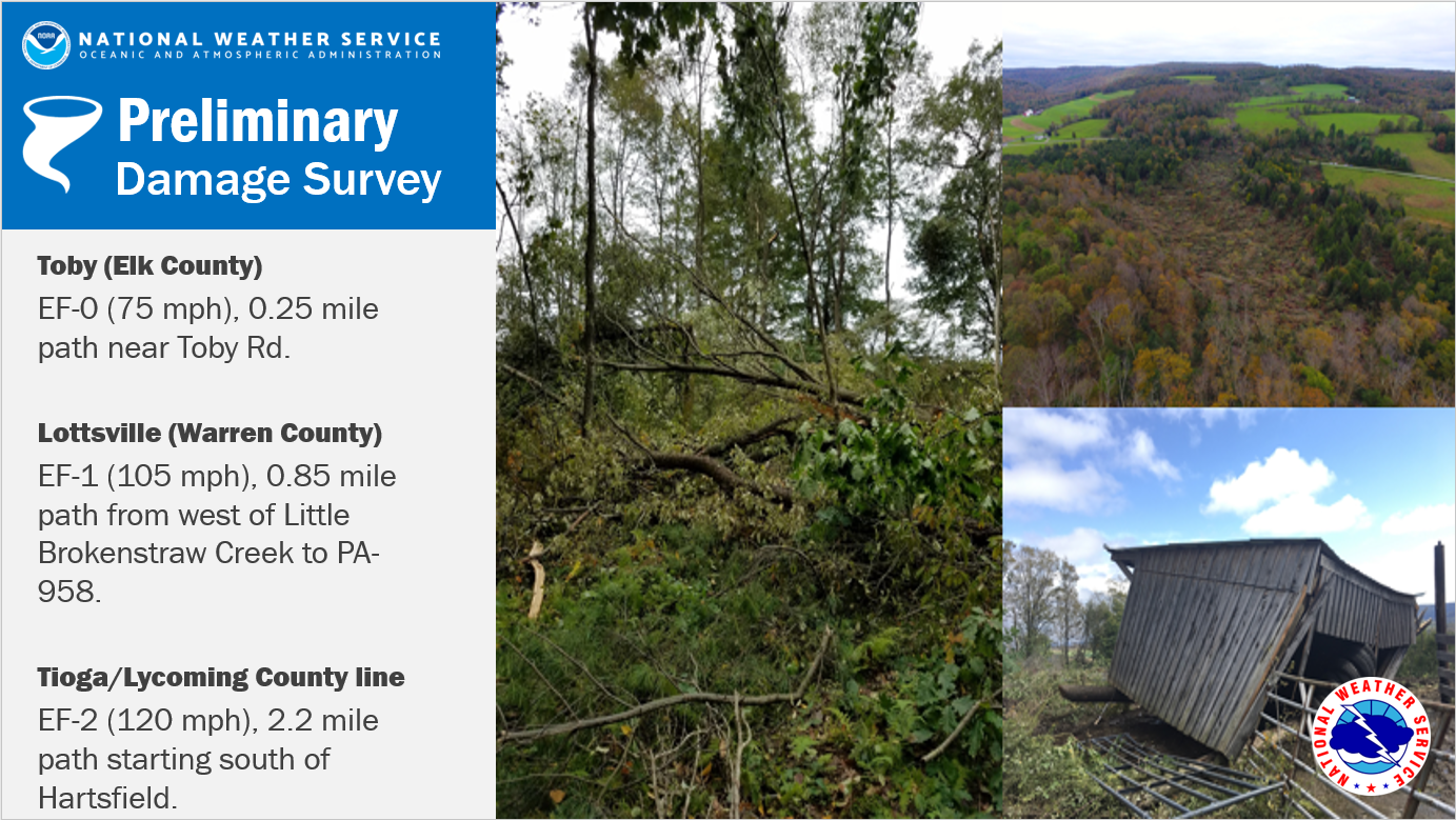
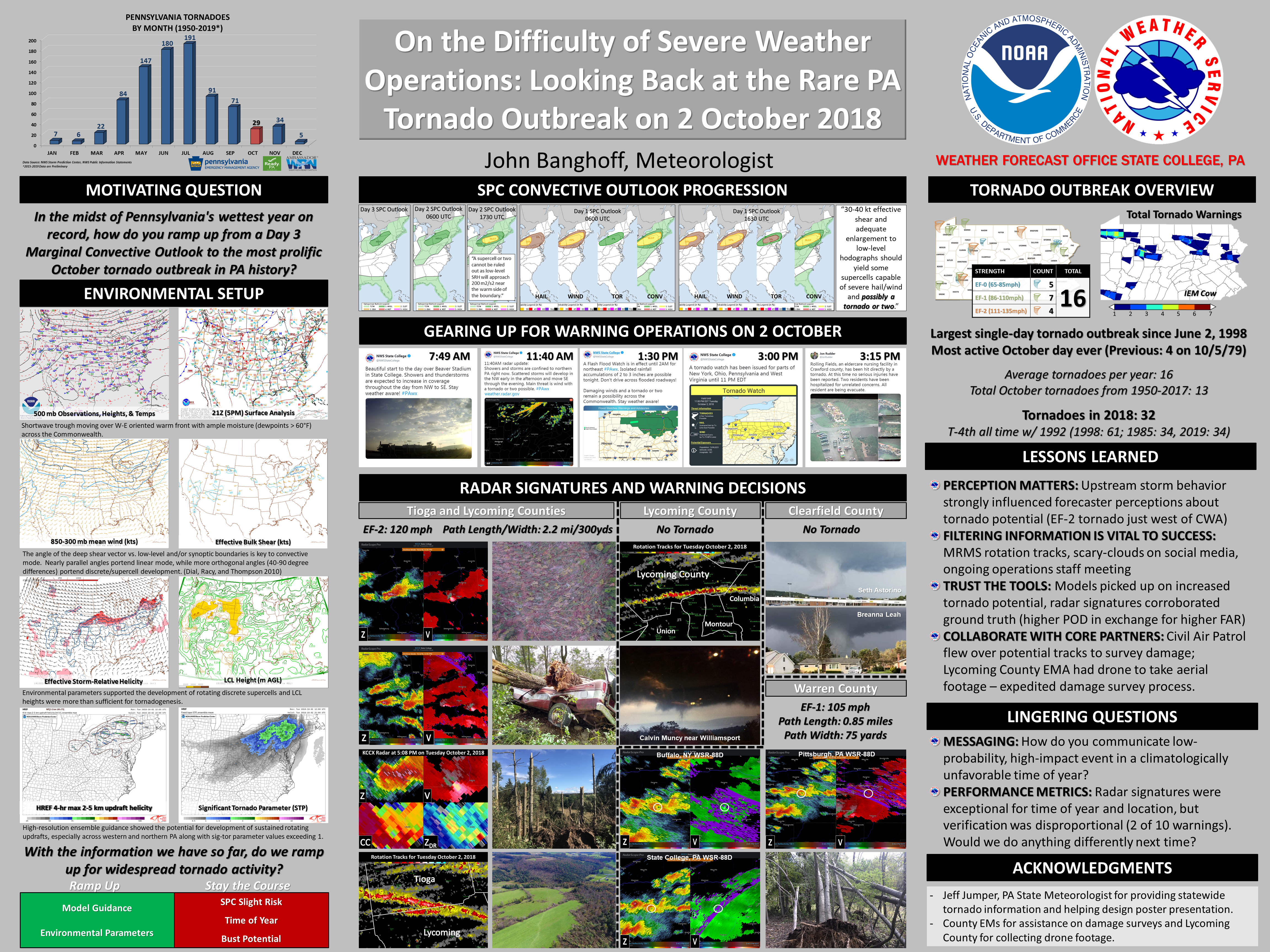
The most active day for tornadoes in october in history for pennsylvania. |
 |
|
Below you can find more information from each damage survey conducted in central PA: |
|
Tioga/Lycoming County Line EF-2 Tornado
Lottsville EF-1 Tornado (Warren County)
Toby EF-0 Tornado (Elk County)
Public Information Statement
National Weather Service State College PA
248 PM EDT Thu Oct 4 2018

...EF-2 TORNADO CONFIRMED IN TIOGA/LYCOMING COUNTY...

Location...Southwest of Liberty along the Tioga/Lycoming County
border Pennsylvania
Date...October 2, 2018
Estimated Start Time...5:03 PM EDT
Estimated End Time...5:08 PM EDT
Beginning Lat/Lon...41.5450N / -77.1782W
Ending Lat/Lon...41.5361N / -77.1380W
Maximum EF-Scale Rating...EF-2
Estimated Maximum Wind Speed...115-120 MPH
Maximum Path Width...300 yards
Path Length...2.2 miles
* Fatalities...0
* Injuries...0

* The information in this statement is preliminary and subject to
change pending final review of the event(s) and publication in
NWS Storm Data.

...Summary...
The National Weather Service in State College PA has confirmed a
tornado southwest of Liberty along the Lycoming/Tioga County
border in Pennsylvania on October 2, 2018.

Hundreds of trees were felled along the Tioga/Lycoming County
border. The damage is characteristic of winds of 115-120 mph
(EF-2 tornado strength). Although the most significant damage was
observed in Lycoming County, some damage from the tornado occurred
in extreme southern Tioga County as well.

To be clear, there was only one confirmed tornado in Tioga/Lycoming
County on October 2, 2018. We apologize for any confusion caused by
previous Public Information Statements.

This information can also be found on our website at
weather.gov/StateCollege.

For reference: the Enhanced Fujita Scale classifies tornadoes
into the following categories:

EF0...Wind speeds 65 to 85 mph
EF1...Wind speeds 86 to 110 mph
EF2...Wind speeds 111 to 135 mph
EF3...Wind speeds 136 to 165 mph
EF4...Wind speeds 166 to 200 mph
EF5...Wind speeds greater than 200 mph

$$
Public Information Statement
National Weather Service State College PA
204 PM EDT Fri Oct 5 2018

...EF-1 TORNADO CONFIRMED IN WARREN COUNTY...

Location...Lottsville in Warren County Pennsylvania
Date...October 2, 2018
Estimated Start Time...3:43 PM EDT
Estimated End Time...3:45 PM EDT
Beginning Lat/Lon...41.9347 / -79.4407
Ending Lat/Lon...41.9367 / -79.4246
Maximum EF-Scale Rating...EF-1
Estimated Maximum Wind Speed...95-105 MPH
Maximum Path Width...75 yards
Path Length...0.85 mile
* Fatalities...0
* Injuries...0

* The information in this statement is preliminary and subject to
change pending final review of the event(s) and publication in
NWS Storm Data.

...Summary...
The National Weather Service in State College PA has confirmed a
tornado near Lottsville in Warren County Pennsylvania on October
2, 2018.

The tornado track began just west of Little Brokenstraw Creek in
Freehold Township. Heavily forested areas were damaged, with dozens
of trees either uprooted or snapped along the path. A concrete chimney
attached to a home was blown over. The tornado crossed from west to
east over PA-958 before dissipating.

This information can also be found on our website at
weather.gov/StateCollege.

For reference: the Enhanced Fujita Scale classifies tornadoes
into the following categories:

EF0...Wind speeds 65 to 85 mph
EF1...Wind speeds 86 to 110 mph
EF2...Wind speeds 111 to 135 mph
EF3...Wind speeds 136 to 165 mph
EF4...Wind speeds 166 to 200 mph
EF5...Wind speeds greater than 200 mph

$$

Colbert
Public Information Statement National Weather Service State College PA 632 PM EDT Sat Oct 13 2018 ...EF-0 TORNADO CONFIRMED IN ELK COUNTY... Location...Toby in Elk County Pennsylvania Date...October 2, 2018 Estimated Start Time...5:05 PM EDT Estimated End Time...5:06 PM EDT Beginning Lat/Lon...41.3300 / -78.6298 Ending Lat/Lon...41.3295 / -78.6265 Maximum EF-Scale Rating...EF-0 Estimated Maximum Wind Speed...65-75 MPH Maximum Path Width...20 yards Path Length...0.25 miles * Fatalities...0 * Injuries...0 * The information in this statement is preliminary and subject to change pending final review of the event(s) and publication in NWS Storm Data. ...Summary... The National Weather Service in State College PA has confirmed a tornado near Toby in Elk County Pennsylvania on October 2, 2018. The tornado brought down several trees in a convergent pattern along a small path near Toby Rd in Toby, PA. Additional damage may have occurred further east along the path, but the area was inaccessible due to rugged terrain. Time is estimated based on radar. Winds are estimated on the lower bound of expected winds for downed trees due to wet soils. This information can also be found on our website at weather.gov/StateCollege. For reference: the Enhanced Fujita Scale classifies tornadoes into the following categories: EF0...Wind speeds 65 to 85 mph EF1...Wind speeds 86 to 110 mph EF2...Wind speeds 111 to 135 mph EF3...Wind speeds 136 to 165 mph EF4...Wind speeds 166 to 200 mph EF5...Wind speeds greater than 200 mph $$ MRC/BMW |
