Overview
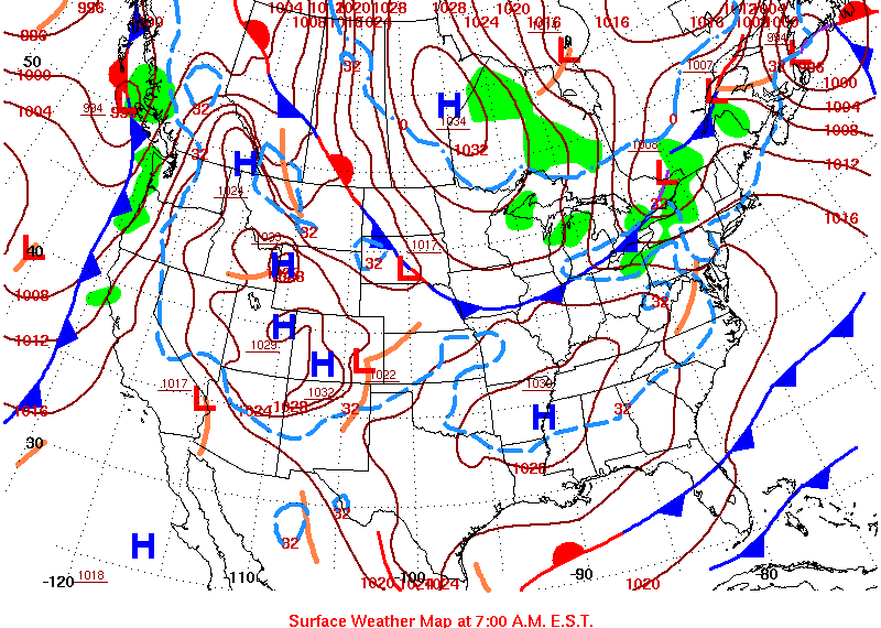
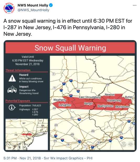
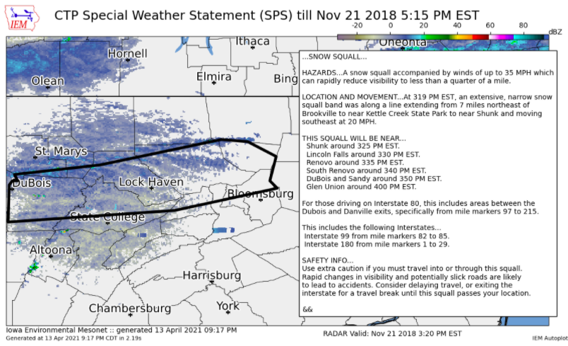
On the day before Thanksgiving 2018, an arctic front moved southward into central PA, bringing with it snow showers and dangerous snow squall conditions that impacted roads on the busiest travel day of the year.Maps
 |
 |
 |
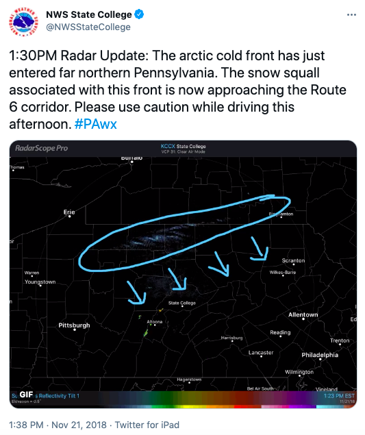 |
| Surface Map at 7:00 AM EST | NWS Snow Squall Warning for I-287, I-476, and I-280 | CTP Special Weather Statement | NWS Snow Squall Update |
Photos & Video
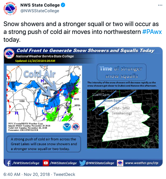 |
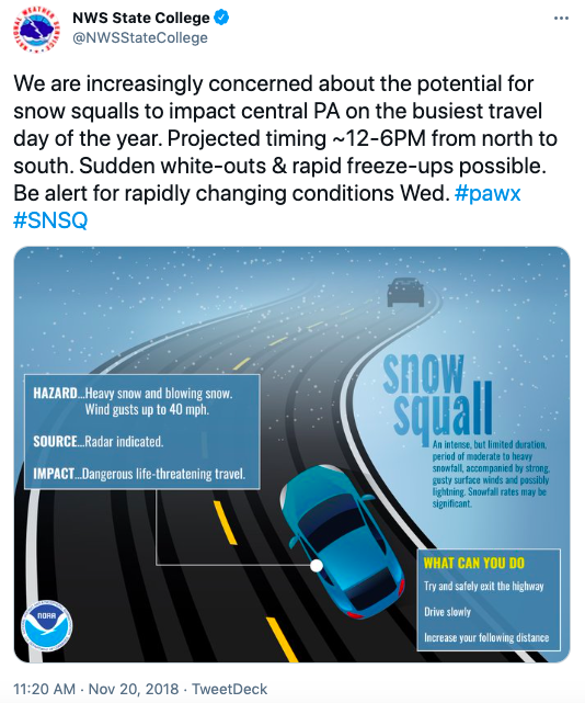 |
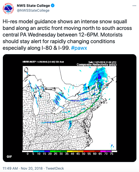 |
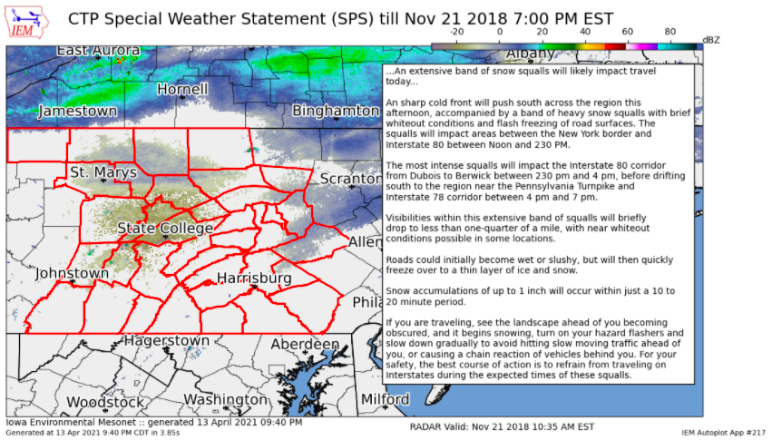 |
| NWS Update Tweet | NWS Snow Squall Awareness Tweet | NWS Snow Squall Update Tweet | CTP Special Weather Statement |
Storm Reports
437
FXUS61 KCTP 210944
AFDCTP
Area Forecast Discussion
National Weather Service State College PA
444 AM EST Wed Nov 21 2018
.SYNOPSIS...
An arctic cold front will push through the area today ushering
in fair weather, but also near-record cold temperatures for
Thanksgiving Day and Friday morning. Temperatures will moderate
over the holiday weekend with a new storm system likely to move
into the region for Saturday into Sunday.
&&
.NEAR TERM /UNTIL 6 PM THIS EVENING/...
Wind already gusty over the west even before the front. The wind
will get a little stronger through the day with sustained
10-20mph and gusts near or above 30mph, esp on the ridges and
along the front/in squalls. 09Z radar mosaic shows a batch of
light returns over wrn PA much like yesterday. The clouds from
this patch of lift will pass rather quickly, unlike yesterday
where the lift was broader and lasted longer. This trough aloft
is moving quickly and is rather small. Therefore, there could be
some better sfc heating/llvl instability with those higher
clouds moving out of the way. The 8H temps drop even further
today, with the -8C contour corresponding to about when the
front is expected to pass. Interestingly, the snow squall
parameter is not as strong as it was yesterday with this 06Z run
of the NAM. This could be an indication that the ferocity of
the expected squalls will not be as bad as previously thought.
However, it is not enough to back off the mentions of sct SQSN.
The most likely timing is still pretty solid with the front
going thru BFD around 17-18Z and FIG/UNV/IPT around 20-21Z. The
west wind ahead of the front will be a negative for the stronger
snow showers/squalls making it into the Lower Susq Valley. Many
hi-res models/HREF members drop all QPF and any CAPE by around
the time the front gets to an AOO-SEG line. As with yesterday,
the moisture is meager, and it even drier with dewpoints about
5F lower than matching times from Tues, and mixed layer not as
tall/deep today. However, the models do hold onto the
indications of precip farther to the south on the whole. The
lift from the Laurels should keep the stronger/gusty snow
showers going into the early evening.
Since SPSs for snow squalls and perhaps even an SQW is possible
today, we will not issue the all-day type SPS at this point.
Will continue to mention the possibility of squalls in the HWO,
since SQWs are possible today.
Maxes in the downslope could get in the m-u40s in Lanc/York cos.
The rest of the area will range from near freezing in the
highest elevs to the lower 40s. These >32F temps could cause
problems if the roads are above freezing as a strong squall and
the front were to move through, and rapid cooling/snow accum
was to then take place.
&&
.SHORT TERM /6 PM THIS EVENING THROUGH THURSDAY NIGHT/...
Any SH/SQSN should be all but done by sunset, as CAPE will be
gone, and the lift from the front will be balanced by the
downslope SE of Blue Mtn. There could be a few SHSN survive over
the Laurels through 00Z, but the flow then becomes NNW, and
yields a fetch off LM. This could produce a brief period of a
few hours where there could be 1-2" accumulate on the west-
facing slopes of the Laurels. Otherwise, the cross-lake fetch is
very short to make any appreciable snow in the nrn mtns. The
fetch off LO could actually push a few LES bands into the far NE
(Tioga/Sullivan Cos) later tonight. The cold and very dry air
mass, lowering subsidence inversion, and non-favorable fetch
will kill off the SHSN later tonight. Mins will be very much
below normal for this date, and could make record mins. The
more-likely places to set records would be the nrn half of the
area in protected valleys. The wind never really quits, so the
mixing could keep temps just above record lows. Wind chills do
drop below zero on the hills late tonight and in the morning.
The sunshine promised for Thanksgiving Day these past few days
is still on tap for the SE, but the sun will at first be hidden
by a few clouds in the NErn counties. Then, a patch of lift
aloft will spread some higher clouds over the west/north through
the day. Overall, mostly sunny will be a good call. Maxes could
stay down below guidance if the clouds do get thick. But, the
going maxes look fine. See the climo section below for a listing
of record temps. The coldest period and most likely to drop some
records might actually be Friday morning. The sky should be
mainly clear and widespread single digits are expected across
the nrn half of the area. It is not out of the question to see a
0F min or two in the nrn mtns, esp the NE where the wind should
be calm most of the night.
&&
.LONG TERM /FRIDAY THROUGH TUESDAY/...
Friday looks cold and mainly sunny. High pressure overhead in
the morning will slide east, and a southeast flow will start up.
Temps should be in the black compared to Thurs, though, rising
some 5-10F higher in the aftn.
Expect precipitation to return to the area on Saturday. The
retreating cold airmass sets up the potential for precipitation
to start as snow or a wintry mix before transitioning to rain.
Any wintry precip would be a high impact given the holiday
weekend and increased travel. Rainfall could reach an inch in
many places across the southern half of the region. This system
should pull out early Saturday night with only a brief respite
until the next system arrives by next Monday. Colder air
wrapping in behind this system should eventually lead to snow
showers downwind of lake Erie with accumulation possible in the
favored snowbelts and upslope locations.
&&
.AVIATION /09Z WEDNESDAY THROUGH SUNDAY/...
06Z TAFS sent.
Main change was to edge winds up overnight.
MVFR to VFR conditions will continue overnight, with the
best conditions across the east and south.
Main push of colder air will be after sunset today. Gusty
winds will prevail today into this evening.
Models hinting at potential for a stronger snow band dropping
southward across the mountains, impacting the northern mountains
late morning/midday and slipping toward I-80 in the afternoon
before washing out over the central mountains. Placed a general
MVFR reduction in visibility in snow timed with the arctic front
Wed. afternoon. The cold air push will be accompanied by wind
gusts that could reach 25-35kts on the ridges and 15-25kts in
the valleys.
Widespread VFR conditions develop for Thu/Fri with high
pressure in control.
.Outlook...
Thu-Fri...No sig wx expected.
Sat...Wintry mix poss early, then restrictions in mainly rain.
Sun...Restrictions likely in rain showers.
&&
.CLIMATE...
Record-challenging cold is forecast for Thanksgiving Day. Both
record low-maximum (daytime) and record low minimum (nighttime)
temperatures are in jeopardy. *State College COOP records for
STCP1 taken between 7am-7am and coordinated with PSU Meteo
Dept.
Record low-min (11/22)
-------------------------
Williamsport: 13 in 2014
Harrisburg: 16 in 1964
Altoona: 13 in 1964
State College: 10 in 1984*
Bradford: 6 in 2008
Record low-max (11/22)
-------------------------
Williamsport: 30 in 2000
Harrisburg: 31 in 1989
Altoona: 27 in 2008
State College: 25 in 1956
Bradford: 20 in 2008
Record low-min (11/23)
-------------------------
Williamsport: 14 in 1964
Harrisburg: 14 in 1964
Altoona: 12 in 2000
State College: 12 in 1984
Bradford: -1 in 1971
&&
.CTP WATCHES/WARNINGS/ADVISORIES...
None.
&&
$$
SYNOPSIS...Dangelo
NEAR TERM...Dangelo
SHORT TERM...Dangelo
LONG TERM...Steinbugl
AVIATION...Martin/RXR/Tyburski
CLIMATE...
 |
Media use of NWS Web News Stories is encouraged! Please acknowledge the NWS as the source of any news information accessed from this site. |
 |