Overview
On July 24-25th, 2018, a slow-moving frontal boundary moved through Pennsylvania, bringing heavy showers and thunderstorms and causing widespread flooding across the state. Rainfall totals across the state over the 4-day period (nearing a foot in some locations) were so high that multiple cities achieved their wettest July on record.

Muddy brown floodwaters in Spring Creek flow beneath the Skyrush roller coaster, painted yellow, and the Comet roller coaster at Hershey Park in Hershey, Pa. The park closed Monday and Wednesday this week. (The Wyse Choice/Associated Press) Source: https://www.washingtonpost.com/news/capital-weather-gang/wp/2018/07/25/major-flooding-is-occurring-in-parts-of-pennsylvania-and-rivers-continue-to-rise-in-the-mid-atlantic/
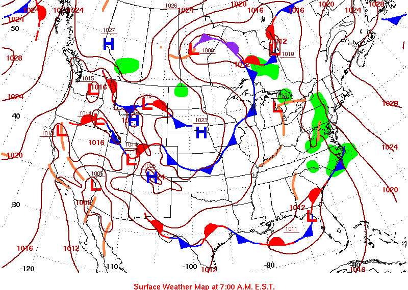 |
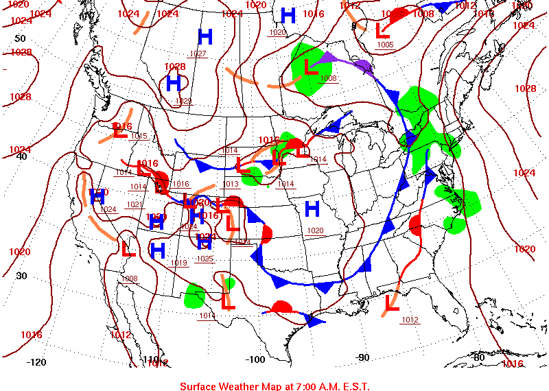 |
| Tuesday, July 24, 2018 Daily Weather Map | Wednesday, July 25, 2018 Daily Weather Map |
MARFC Flood Statistics
July 25, 2018 7-Day Observed Precipitation
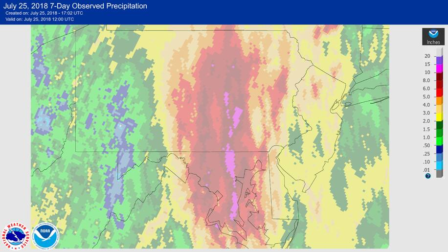
Forecasted & Estimated Precipitation
Forecasted & Estimatd Precipitation
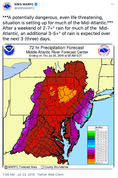 |
 |
 |
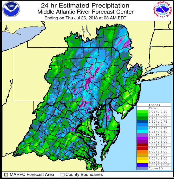 |
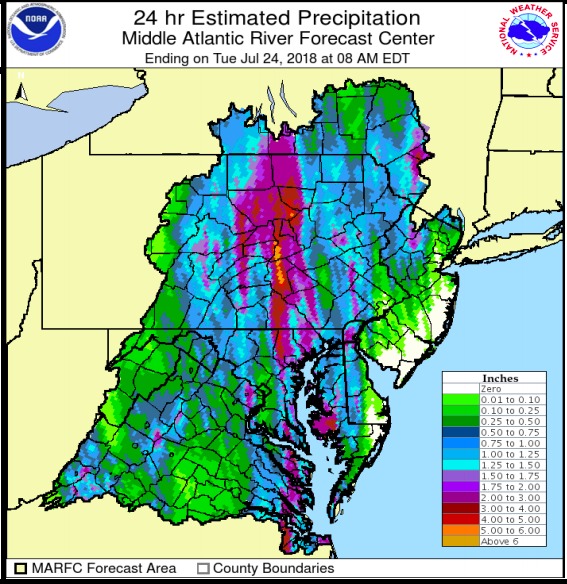
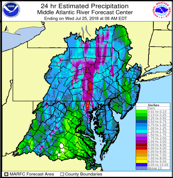
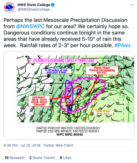
| Tweet regarding precipitation amounts | 24 hr ending on Tue July 24, 2018 | 24 hr ending on Wed July 25, 2018 | 24 hr ending on Thur July 26, 2018 |
Precipitation Products
 |
 |
 |
 |
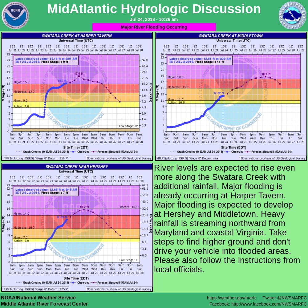
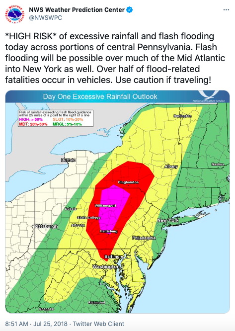
| Flash Flood Mesoscale Discussion #1 | Mid-Atlantic Hydrologic Discussion | Excessive Rainfall Risk | Flash Flood Mesoscale Discussion #2 |
Record Events
 |
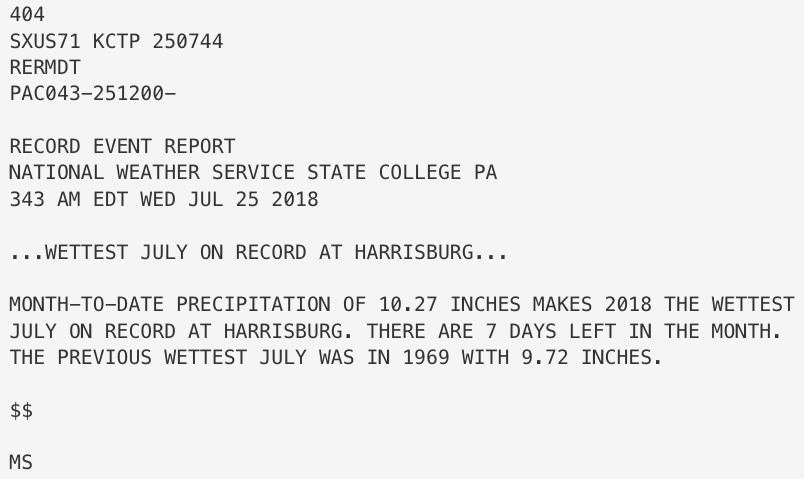 |
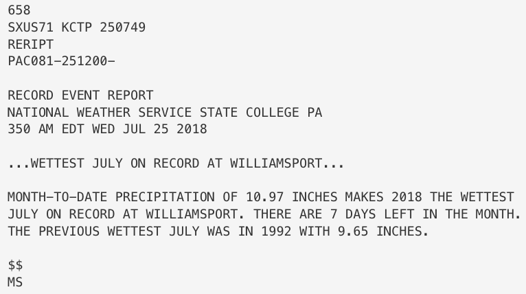
| Wettest July Williamsport Record | Wettest July Harrisburg Record |
Storm Reports
Public Information Statement (PNS)
429
NOUS41 KCTP 261708
PNSCTP
PAZ004>005-010>012-017>019-024>028-033>034-037-041>042-045>046-
049>053-056>059-063-065>066-270508-
Public Information Statement
Spotter Reports
National Weather Service State College PA
108 PM EDT Thu Jul 26 2018
Observations are collected from a variety of sources with varying
equipment and exposure. Not all data listed are considered official.
This summary is also available on our home page at
weather.gov/statecollege
********************STORM TOTAL RAINFALL********************
LOCATION STORM TOTAL TIME/DATE COMMENTS
RAINFALL OF
/INCHES/ MEASUREMENT
PENNSYLVANIA
...Adams County...
1 NNW Fairfield 11.96 600 AM 7/26 CoCoRaHS
9 NE Fayetteville 10.80 715 AM 7/26 Co-Op Observer
Cashtown 1s 10.43 700 AM 7/26 Co-Op Observer
2 WNW Cashtown 10.09 1130 AM 7/25 CoCoRaHS
1 ESE Arendtsville 8.75 700 AM 7/26 CoCoRaHS
Arendtsville 8.51 700 AM 7/26 CoCoRaHS
York Springs 8.02 700 AM 7/26 CoCoRaHS
4 WNW Cashtown 7.85 700 AM 7/26 CoCoRaHS
4 E Fairfield 7.30 700 AM 7/26 CoCoRaHS
1 NNE Harney 7.04 700 AM 7/26 CoCoRaHS
Hanover 6.80 800 AM 7/26 Co-Op Observer
1 ESE Germantown 6.77 700 AM 7/26 CoCoRaHS
1 SE New Oxford 6.45 730 AM 7/25 CoCoRaHS
1 SSW East Berlin 6.27 700 AM 7/26 CoCoRaHS
WSW New Oxford 6.15 800 AM 7/25 CoCoRaHS
1 E Mcsherrystown 5.92 700 AM 7/24 CoCoRaHS
Biglerville 5.87 800 AM 7/23 CoCoRaHS
...Centre County...
1 ENE Boalsburg 6.51 700 AM 7/26 CoCoRaHS
Boalsburg 6.46 700 AM 7/26 CoCoRaHS
Nittany Mall 6.04 700 AM 7/26 NWS Employee
2 ENE State College 5.59 900 AM 7/26 CoCoRaHS
1 W Zion 5.38 800 AM 7/26 CoCoRaHS
State College 5.04 800 AM 7/26 Co-Op Observer
...Clinton County...
Lock Haven 6.12 700 AM 7/25 Co-Op Observer
...Columbia County...
2 NW Natalie 11.09 1200 AM 7/26 Co-Op Observer
2 SW Almedia 7.09 700 AM 7/26 CoCoRaHS
...Cumberland County...
Carlisle 8.50 715 PM 7/25 Co-Op Observer
Pine Grove Furnace 7.03 800 AM 7/26 Co-Op Observer
1 SSW Marysville 6.66 700 AM 7/26 CoCoRaHS
...Dauphin County...
1 SSW Grantville 14.64 800 AM 7/26 CoCoRaHS
Dehart Dam 13.57 706 AM 7/25 Co-Op Observer
2 NE Highspire 10.16 800 AM 7/26 CoCoRaHS
Linglestown 9.76 700 AM 7/26 CoCoRaHS
1 NE Harrisburg 9.09 700 AM 7/26 Co-Op Observer
1 N Elizabethville 6.40 115 PM 7/24 Co-Op Observer
1 NNE Harrisburg 5.55 707 AM 7/26 CoCoRaHS
...Franklin County...
South Mountain 6.59 735 AM 7/26 Co-Op Observer
2 W Waynesboro 6.14 700 AM 7/25 CoCoRaHS
...Fulton County...
Mcconnelsburg 5.50 130 PM 7/25 Co-Op Observer
...Huntingdon County...
Three Springs 7.70 745 AM 7/26 Co-Op Observer
2 S Broad Top City 6.10 1000 PM 7/25 CoCoRaHS
Mount Union 5.30 715 PM 7/25 Co-Op Observer
...Juniata County...
Perulack 6.50 730 PM 7/25 Co-Op Observer
...Lancaster County...
Mountville 8.83 700 AM 7/26 CoCoRaHS
Safe Harbor Dam 7.73 800 AM 7/26 Co-Op Observer
2 ENE Lancaster 7.41 800 AM 7/26 Co-Op Observer
Holtwood 6.56 800 AM 7/26 Co-Op Observer
Millersville 6.23 800 AM 7/26 Co-Op Observer
2 SSE Landisville 6.00 700 AM 7/26 CoCoRaHS
1 SSE Landisville 5.73 900 AM 7/25 CoCoRaHS
...Lebanon County...
2 W Lebanon 12.24 1200 AM 7/26 Co-Op Observer
4 SSW Newmanstown 6.32 700 AM 7/26 CoCoRaHS
...Lycoming County...
3 NW Unityville 6.70 745 PM 7/25 Co-Op Observer
Slate Run 5.50 745 AM 7/26 Co-Op Observer
...Mifflin County...
1 SSE Lewistown 5.81 700 AM 7/26 Co-Op Observer
Milroy 5.30 730 AM 7/26 Co-Op Observer
...Northumberland County...
1 W Mount Carmel 13.26 600 AM 7/26 CoCoRaHS
Sunbury 10.82 735 AM 7/26 Co-Op Observer
2 N Turbotville 10.27 700 AM 7/26 CoCoRaHS
...Potter County...
Cherry Springs 5.70 715 AM 7/26 Co-Op Observer
...Schuylkill County...
1 SW Valley View 11.47 600 AM 7/26 CoCoRaHS
4 N Tamaqua 8.39 745 AM 7/26 Co-Op Observer
2 N Mahanoy City 6.75 700 AM 7/25 Co-Op Observer
...Snyder County...
2 S Selinsgrove 11.88 700 AM 7/26 Co-Op Observer
...Sullivan County...
Laporte 7.48 724 AM 7/26 Co-Op Observer
Dushore 5.97 800 AM 7/25 Co-Op Observer
...Tioga County...
Covington 2wsw 7.02 300 AM 7/26 Co-Op Observer
4 SW Wellsboro 6.03 700 AM 7/26 Co-Op Observer
Crooked Creek 5.77 1100 AM 7/26 Co-Op Observer
Cowanesque Dam 5.29 1100 AM 7/26 Co-Op Observer
...Union County...
Lewisburg 8.43 700 AM 7/26 Co-Op Observer
1 WNW Mifflinburg 7.71 700 AM 7/26 CoCoRaHS
...York County...
1 ESE Manchester 11.89 700 AM 7/26 CoCoRaHS
1 NE Weigelstown 10.35 500 AM 7/26 CoCoRaHS
3 W Manchester 9.84 600 AM 7/26 CoCoRaHS
Parkville 9.50 517 AM 7/26 CoCoRaHS
Valley Green 9.40 600 AM 7/26 CoCoRaHS
1 WSW Emigsville 8.16 700 AM 7/26 CoCoRaHS
Manchester 7.45 700 AM 7/25 CoCoRaHS
&&
*****METADATA*****
:7/26/2018, 600 AM, PA, Adams, Fairfield, 1, NNW, 39.81342, -77.37639, RAIN, 11.96, Inch, CoCoRaHS,
:7/26/2018, 715 AM, PA, Adams, Fayetteville, 9, NE, 39.98330, -77.40000, RAIN, 10.80, Inch, Co-Op Observer,
:7/26/2018, 700 AM, PA, Adams, Cashtown 1s, , , 39.87000, -77.35860, RAIN, 10.43, Inch, Co-Op Observer,
:7/25/2018, 1130 AM, PA, Adams, Cashtown, 2, WNW, 39.88960, -77.37560, RAIN, 10.09, Inch, CoCoRaHS,
:7/26/2018, 700 AM, PA, Adams, Arendtsville, 1, ESE, 39.91471, -77.27928, RAIN, 8.75, Inch, CoCoRaHS,
:7/26/2018, 700 AM, PA, Adams, Arendtsville, , , 39.91978, -77.30131, RAIN, 8.51, Inch, CoCoRaHS,
:7/26/2018, 700 AM, PA, Adams, York Springs, , , 40.00139, -77.10889, RAIN, 8.02, Inch, CoCoRaHS,
:7/26/2018, 700 AM, PA, Adams, Cashtown, 4, WNW, 39.92090, -77.40310, RAIN, 7.85, Inch, CoCoRaHS,
:7/26/2018, 700 AM, PA, Adams, Fairfield, 4, E, 39.77394, -77.29035, RAIN, 7.30, Inch, CoCoRaHS,
:7/26/2018, 700 AM, PA, Adams, Harney, 1, NNE, 39.73050, -77.20280, RAIN, 7.04, Inch, CoCoRaHS,
:7/26/2018, 800 AM, PA, Adams, Hanover, , , 39.77090, -77.03320, RAIN, 6.80, Inch, Co-Op Observer,
:7/26/2018, 700 AM, PA, Adams, Germantown, 1, ESE, 39.75826, -77.13058, RAIN, 6.77, Inch, CoCoRaHS,
:7/25/2018, 730 AM, PA, Adams, New Oxford, 1, SE, 39.84630, -77.04370, RAIN, 6.45, Inch, CoCoRaHS,
:7/26/2018, 700 AM, PA, Adams, East Berlin, 1, SSW, 39.91918, -76.98942, RAIN, 6.27, Inch, CoCoRaHS,
:7/25/2018, 800 AM, PA, Adams, New Oxford, , WSW, 39.86080, -77.06181, RAIN, 6.15, Inch, CoCoRaHS,
:7/24/2018, 700 AM, PA, Adams, Mcsherrystown, 1, E, 39.80066, -77.00083, RAIN, 5.92, Inch, CoCoRaHS,
:7/23/2018, 800 AM, PA, Adams, Biglerville, , , 39.92608, -77.24788, RAIN, 5.87, Inch, CoCoRaHS,
:7/26/2018, 700 AM, PA, Centre, Boalsburg, 1, ENE, 40.78139, -77.77068, RAIN, 6.51, Inch, CoCoRaHS,
:7/26/2018, 700 AM, PA, Centre, Boalsburg, , , 40.77361, -77.78471, RAIN, 6.46, Inch, CoCoRaHS,
:7/26/2018, 700 AM, PA, Centre, Nittany Mall, , , 40.82545, -77.81436, RAIN, 6.04, Inch, NWS Employee,
:7/26/2018, 900 AM, PA, Centre, State College, 2, ENE, 40.80670, -77.81670, RAIN, 5.59, Inch, CoCoRaHS,
:7/26/2018, 800 AM, PA, Centre, Zion, 1, W, 40.92491, -77.68687, RAIN, 5.38, Inch, CoCoRaHS,
:7/26/2018, 800 AM, PA, Centre, State College, , , 40.80000, -77.86670, RAIN, 5.04, Inch, Co-Op Observer,
:7/25/2018, 700 AM, PA, Clinton, Lock Haven, , , 41.11670, -77.45000, RAIN, 6.12, Inch, Co-Op Observer,
:7/26/2018, 1200 AM, PA, Columbia, Natalie, 2, NW, 40.83330, -76.50000, RAIN, 11.09, Inch, Co-Op Observer,
:7/26/2018, 700 AM, PA, Columbia, Almedia, 2, SW, 40.99289, -76.41503, RAIN, 7.09, Inch, CoCoRaHS,
:7/25/2018, 715 PM, PA, Cumberland, Carlisle, , , 40.22580, -77.18940, RAIN, 8.50, Inch, Co-Op Observer,
:7/26/2018, 800 AM, PA, Cumberland, Pine Grove Furnace, , , 40.03330, -77.30000, RAIN, 7.03, Inch, Co-Op Observer,
:7/26/2018, 700 AM, PA, Cumberland, Marysville, 1, SSW, 40.31330, -76.93860, RAIN, 6.66, Inch, CoCoRaHS,
:7/26/2018, 800 AM, PA, Dauphin, Grantville, 1, SSW, 40.38649, -76.66210, RAIN, 14.64, Inch, CoCoRaHS,
:7/25/2018, 706 AM, PA, Dauphin, Dehart Dam, , , 40.46000, -76.74890, RAIN, 13.57, Inch, Co-Op Observer,
:7/26/2018, 800 AM, PA, Dauphin, Highspire, 2, NE, 40.23486, -76.76168, RAIN, 10.16, Inch, CoCoRaHS,
:7/26/2018, 700 AM, PA, Dauphin, Linglestown, , , 40.33190, -76.79993, RAIN, 9.76, Inch, CoCoRaHS,
:7/26/2018, 700 AM, PA, Dauphin, Harrisburg, 1, NE, 40.28170, -76.87030, RAIN, 9.09, Inch, Co-Op Observer,
:7/24/2018, 115 PM, PA, Dauphin, Elizabethville, 1, N, 40.56670, -76.81670, RAIN, 6.40, Inch, Co-Op Observer,
:7/26/2018, 707 AM, PA, Dauphin, Harrisburg, 1, NNE, 40.29633, -76.87095, RAIN, 5.55, Inch, CoCoRaHS,
:7/26/2018, 735 AM, PA, Franklin, South Mountain, , , 39.85000, -77.50000, RAIN, 6.59, Inch, Co-Op Observer,
:7/25/2018, 700 AM, PA, Franklin, Waynesboro, 2, W, 39.74446, -77.62960, RAIN, 6.14, Inch, CoCoRaHS,
:7/25/2018, 130 PM, PA, Fulton, Mcconnelsburg, , , 39.93330, -78.00000, RAIN, 5.50, Inch, Co-Op Observer,
:7/26/2018, 745 AM, PA, Huntingdon, Three Springs, , , 40.20000, -78.00000, RAIN, 7.70, Inch, Co-Op Observer,
:7/25/2018, 1000 PM, PA, Huntingdon, Broad Top City, 2, S, 40.16754, -78.13631, RAIN, 6.10, Inch, CoCoRaHS,
:7/25/2018, 715 PM, PA, Huntingdon, Mount Union, , , 40.38500, -77.87890, RAIN, 5.30, Inch, Co-Op Observer,
:7/25/2018, 730 PM, PA, Juniata, Perulack, , , 40.36670, -77.65000, RAIN, 6.50, Inch, Co-Op Observer,
:7/26/2018, 700 AM, PA, Lancaster, Mountville, , , 40.04617, -76.44075, RAIN, 8.83, Inch, CoCoRaHS,
:7/26/2018, 800 AM, PA, Lancaster, Safe Harbor Dam, , , 39.92440, -76.39110, RAIN, 7.73, Inch, Co-Op Observer,
:7/26/2018, 800 AM, PA, Lancaster, Lancaster, 2, ENE, 40.05000, -76.28330, RAIN, 7.41, Inch, Co-Op Observer,
:7/26/2018, 800 AM, PA, Lancaster, Holtwood, , , 39.83330, -76.33330, RAIN, 6.56, Inch, Co-Op Observer,
:7/26/2018, 800 AM, PA, Lancaster, Millersville, , , 39.99600, -76.35110, RAIN, 6.23, Inch, Co-Op Observer,
:7/26/2018, 700 AM, PA, Lancaster, Landisville, 2, SSE, 40.06340, -76.40720, RAIN, 6.00, Inch, CoCoRaHS,
:7/25/2018, 900 AM, PA, Lancaster, Landisville, 1, SSE, 40.07696, -76.41174, RAIN, 5.73, Inch, CoCoRaHS,
:7/26/2018, 1200 AM, PA, Lebanon, Lebanon, 2, W, 40.31670, -76.46670, RAIN, 12.24, Inch, Co-Op Observer,
:7/26/2018, 700 AM, PA, Lebanon, Newmanstown, 4, SSW, 40.29997, -76.25669, RAIN, 6.32, Inch, CoCoRaHS,
:7/25/2018, 745 PM, PA, Lycoming, Unityville, 3, NW, 41.28330, -76.53330, RAIN, 6.70, Inch, Co-Op Observer,
:7/26/2018, 745 AM, PA, Lycoming, Slate Run, , , 41.46860, -77.56810, RAIN, 5.50, Inch, Co-Op Observer,
:7/26/2018, 700 AM, PA, Mifflin, Lewistown, 1, SSE, 40.58330, -77.56670, RAIN, 5.81, Inch, Co-Op Observer,
:7/26/2018, 730 AM, PA, Mifflin, Milroy, , , 40.73330, -77.63330, RAIN, 5.30, Inch, Co-Op Observer,
:7/26/2018, 600 AM, PA, Northumberland, Mount Carmel, 1, W, 40.79898, -76.43217, RAIN, 13.26, Inch, CoCoRaHS,
:7/26/2018, 735 AM, PA, Northumberland, Sunbury, , , 40.85440, -76.79250, RAIN, 10.82, Inch, Co-Op Observer,
:7/26/2018, 700 AM, PA, Northumberland, Turbotville, 2, N, 41.13611, -76.76509, RAIN, 10.27, Inch, CoCoRaHS,
:7/26/2018, 715 AM, PA, Potter, Cherry Springs, , , 41.66670, -77.81670, RAIN, 5.70, Inch, Co-Op Observer,
:7/26/2018, 600 AM, PA, Schuylkill, Valley View, 1, SW, 40.64370, -76.54848, RAIN, 11.47, Inch, CoCoRaHS,
:7/26/2018, 745 AM, PA, Schuylkill, Tamaqua, 4, N, 40.85000, -75.98330, RAIN, 8.39, Inch, Co-Op Observer,
:7/25/2018, 700 AM, PA, Schuylkill, Mahanoy City, 2, N, 40.83330, -76.13330, RAIN, 6.75, Inch, Co-Op Observer,
:7/26/2018, 700 AM, PA, Snyder, Selinsgrove, 2, S, 40.78310, -76.86110, RAIN, 11.88, Inch, Co-Op Observer,
:7/26/2018, 724 AM, PA, Sullivan, Laporte, , , 41.42470, -76.49250, RAIN, 7.48, Inch, Co-Op Observer,
:7/25/2018, 800 AM, PA, Sullivan, Dushore, , , 41.52160, -76.40430, RAIN, 5.97, Inch, Co-Op Observer,
:7/26/2018, 300 AM, PA, Tioga, Covington 2wsw, , , 41.73330, -77.11670, RAIN, 7.02, Inch, Co-Op Observer,
:7/26/2018, 700 AM, PA, Tioga, Wellsboro, 4, SW, 41.70030, -77.38940, RAIN, 6.03, Inch, Co-Op Observer,
:7/26/2018, 1100 AM, PA, Tioga, Crooked Creek, , , 41.85000, -77.28330, RAIN, 5.77, Inch, Co-Op Observer,
:7/26/2018, 1100 AM, PA, Tioga, Cowanesque Dam, , , 41.98330, -77.16670, RAIN, 5.29, Inch, Co-Op Observer,
:7/26/2018, 700 AM, PA, Union, Lewisburg, , , 40.94860, -76.87830, RAIN, 8.43, Inch, Co-Op Observer,
:7/26/2018, 700 AM, PA, Union, Mifflinburg, 1, WNW, 40.93000, -77.07000, RAIN, 7.71, Inch, CoCoRaHS,
:7/26/2018, 700 AM, PA, York, Manchester, 1, ESE, 40.04881, -76.69478, RAIN, 11.89, Inch, CoCoRaHS,
:7/26/2018, 500 AM, PA, York, Weigelstown, 1, NE, 40.00200, -76.80800, RAIN, 10.35, Inch, CoCoRaHS,
:7/26/2018, 600 AM, PA, York, Manchester, 3, W, 40.05739, -76.78860, RAIN, 9.84, Inch, CoCoRaHS,
:7/26/2018, 517 AM, PA, York, Parkville, , , 39.79539, -76.97133, RAIN, 9.50, Inch, CoCoRaHS,
:7/26/2018, 600 AM, PA, York, Valley Green, , , 40.16119, -76.77910, RAIN, 9.40, Inch, CoCoRaHS,
:7/26/2018, 700 AM, PA, York, Emigsville, 1, WSW, 39.99646, -76.75330, RAIN, 8.16, Inch, CoCoRaHS,
:7/25/2018, 700 AM, PA, York, Manchester, , , 40.07129, -76.72305, RAIN, 7.45, Inch, CoCoRaHS,
$$
JRB
 |
Media use of NWS Web News Stories is encouraged! Please acknowledge the NWS as the source of any news information accessed from this site. |
 |