Overview
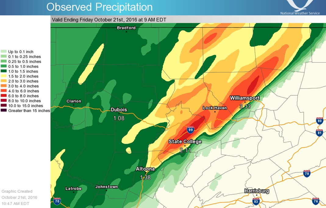
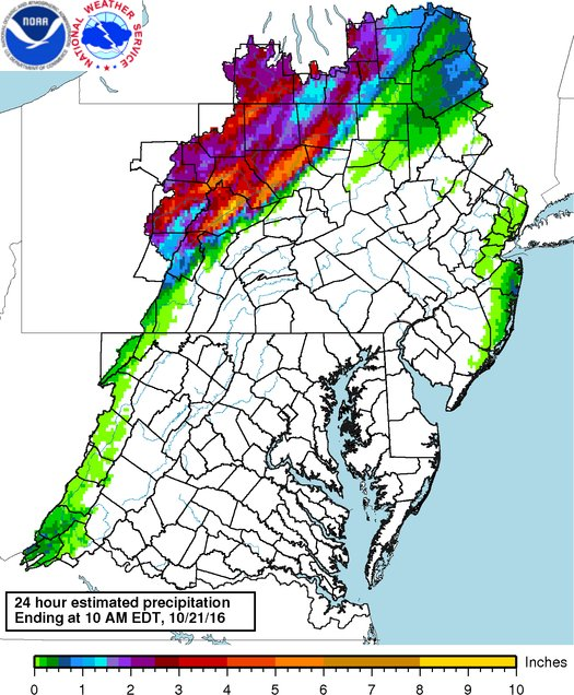
Thunderstorms produced from 3 to as much as 7 inches of rain on the overnight hours of October 20, 2016 in parts of central PA. The heavy rainfall led to flooding in Lycoming, Centre, and Sullivan Counties, and the Centre County Commissioners declared a disaster emergency. As a result of this event, one person was killed, several homes and businesses were damaged, and 100 residents had to be rescued from their homes.
 |
 |
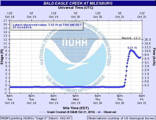 |
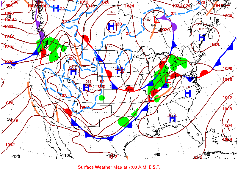
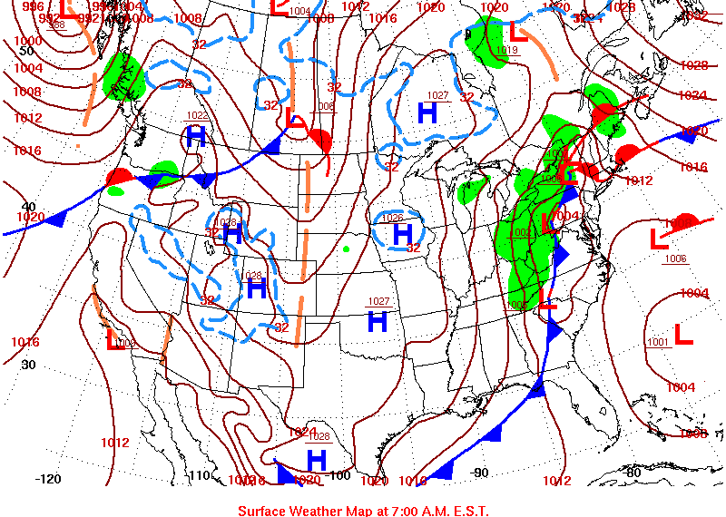
| WPC Daily Weather Map 10/20/16 | WPC Daily Weather Map 10/21/16 | 9.21ft = 3rd highest crest on Bald Eagle Creek in Milesburg; The top 2 crests were with Ivan (12.15ft) in 2004 and Agnes (11.67ft) in 1972. |
Flooding
Maps
 |
 |
 |
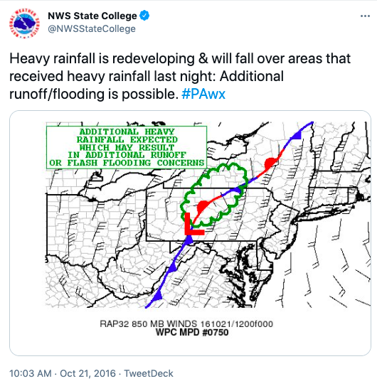 |
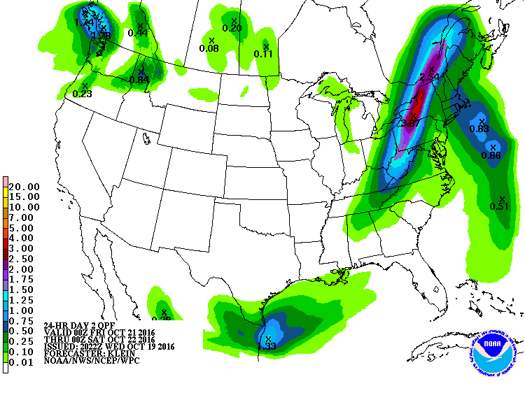
| 24-Hour QPF 00Z October 21 - 00Z October 22, 2016 | Observed Precipitation Ending Friday October 21st, 2016 at 9AM EDT | 24-Hour Estimated Precipitation Ending at 10AM EDT, 10/21/16 | NWS State College Tweet |
Associated Warnings
 |
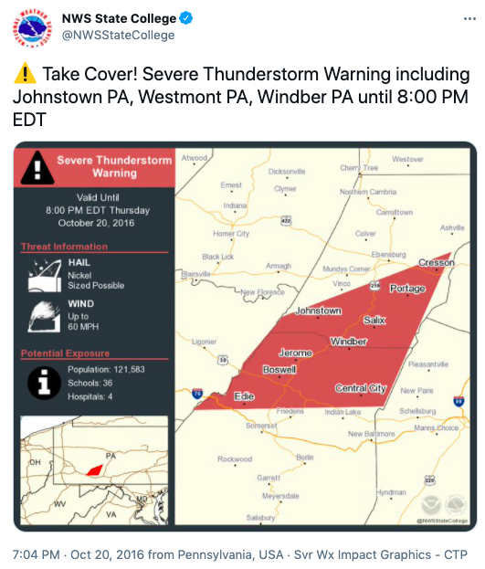 |
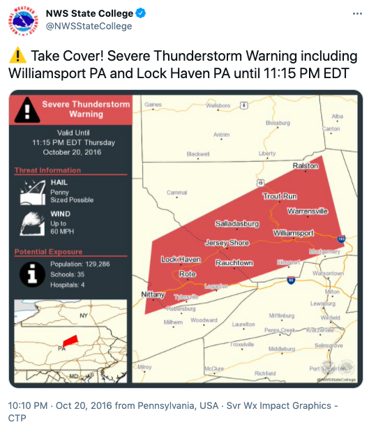 |
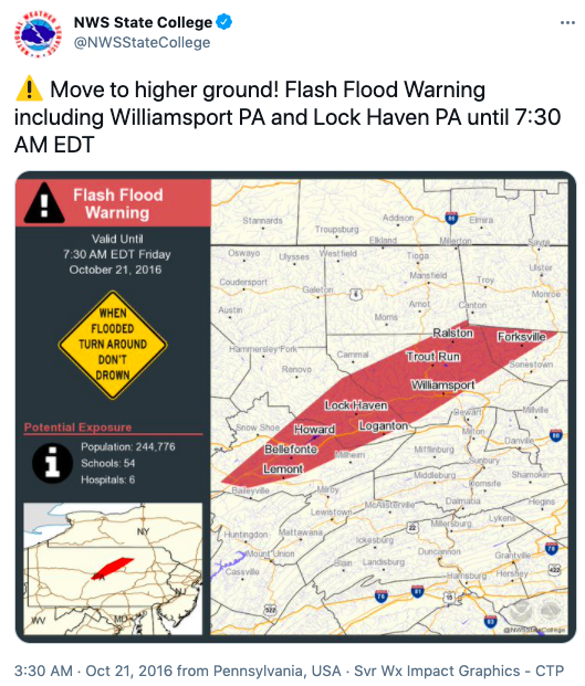 |
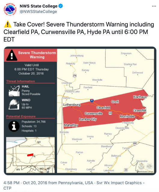
| Severe Thunderstorm Warning including Clearfield, Curwensville, and Hyde PA | Severe Thunderstorm Warning including Johnstown, Westmont, and Windber PA | Severe Thunderstorm Warning including Williamsport and Lock Haven PA | Flash Flood Warning including Williamsport and Lock Haven PA |
Storm Reports
Public Information Statement
National Weather Service State College PA
954 AM EDT Fri Oct 21 2016
...24 Hour Rainfall Reports 1.50 inches or greater...
Location Amount Time/Date Provider
...Blair County...
Tyrone 3.90 in 0734 AM 10/21 COOP
Tyrone 3.26 in 0937 AM 10/21 CWOP
...Cambria County...
3 S Coalport 2.11 in 0931 AM 10/21 CWOP
Belmont 1.50 in 0800 AM 10/21 COCORAHS
...Cameron County...
2 ESE Stevenson Dam 2.10 in 0900 AM 10/21 COOP
1 ESE Emporium 1.73 in 0916 AM 10/21 CWOP
...Centre County...
2 W Park Forest 7.20 in 0943 AM 10/21 CWOP
2 SE Unionville 7.11 in 0933 AM 10/21 CWOP
3 WNW Park Forest 6.75 in 0934 AM 10/21 CWOP
1 WSW Bellefonte 6.72 in 0721 AM 10/21 COCORAHS
2 SW Beech Creek 5.68 in 0931 AM 10/21 HADS
Park Forest 5.24 in 0936 AM 10/21 CWOP
2 ESE Port Matilda 5.01 in 0938 AM 10/21 CWOP
2 E Port Matilda 5.01 in 0943 AM 10/21 CWOP
State College 2.6 NW 4.91 in 0700 AM 10/21 COCORAHS
2 E Port Matilda 4.80 in 0700 AM 10/21 COCORAHS
Stormstown 4.43 in 0900 AM 10/21 SPOTTER
1 W Zion 2.53 in 0800 AM 10/21 COCORAHS
Clarence 1.76 in 0600 AM 10/21 COOP
State College 1.70 in 0945 AM 10/21 CWOP
3 ENE State College 1.69 in 0943 AM 10/21 CWOP
2 S Philipsburg 1.67 in 0800 AM 10/21 COOP
State College 1.54 in 0800 AM 10/21 COOP
...Clearfield County...
Piper 4.00 in 0730 AM 10/21 COOP
Kennedy Preserve 3.05 in 0908 AM 10/21 RAWS
1 N Dubois 3.00 in 0935 AM 10/21 CWOP
Clearfield Airport 2.23 in 0754 AM 10/21 ASOS
...Clinton County...
1 NW Mill Hall 5.34 in 0932 AM 10/21 CWOP
5 S Renovo 3.70 in 0730 AM 10/21 COOP
Lock Haven 3.22 in 0700 AM 10/21 COOP
Coffin Rock 3.08 in 0916 AM 10/21 RAWS
1 E Kettle Creek State Park 2.73 in 0900 AM 10/21 HADS
...Elk County...
E. Branch Clarion Lake 2.38 in 0915 AM 10/21 GOES
3 NW Saint Marys 2.21 in 0934 AM 10/21 CWOP
Glen Hazel 1.85 in 0700 AM 10/21 COOP
1 SE Saint Marys 1.78 in 0700 AM 10/21 COCORAHS
...Lycoming County...
1 NNE Williamsport 4.64 in 0700 AM 10/21 COCORAHS
Loyalsockville 3.63 in 0946 AM 10/21 HADS
Slate Run 3.60 in 0830 AM 10/21 COOP
Cedar Run 2.91 in 0915 AM 10/21 HADS
2 SSE English Center 2.69 in 0940 AM 10/21 CWOP
Duboistown 1.90 in 0944 AM 10/21 CWOP
...McKean County...
2 ENE Eldred 2.83 in 0930 AM 10/21 GOES
2 SSE Kinzua Bridge State Pa 2.39 in 0910 AM 10/21 CWOP
Port Allegany 2.15 in 0845 AM 10/21 HADS
4 W Bradford 1.90 in 0800 AM 10/21 COOP
1 SSE Rew 1.83 in 0939 AM 10/21 CWOP
Bradford Airport 1.62 in 0753 AM 10/21 ASOS
...Potter County...
5 SSW Galeton 3.02 in 0944 AM 10/21 CWOP
Coudersport 7se 2.58 in 0700 AM 10/21 COOP
1 N Shinglehouse 2.49 in 0845 AM 10/21 GOES
Cherry Springs 2.40 in 0800 AM 10/21 COOP
2 ENE Sizerville 2.40 in 0800 AM 10/21 HADS
3 ESE Coudersport 2.39 in 0942 AM 10/21 CWOP
Coudersport 1 SW 2.17 in 0700 AM 10/21 COOP
1 NE Oswayo 1.80 in 0800 AM 10/21 COOP
2 NNE Roulette 1.75 in 0700 AM 10/21 COCORAHS
5 SE Coudersport 1.63 in 1100 PM 10/20 COCORAHS
...Somerset County...
Seven Springs 1.61 in 0939 AM 10/21 CWOP
...Tioga County...
Old Mountain 2.76 in 0916 AM 10/21 RAWS
Mansfield 2.53 in 0931 AM 10/21 GOES
Covington 2wsw 2.50 in 0800 AM 10/21 COOP
3 SW Osceola 2.40 in 0700 AM 10/21 COOP
Cowanesque Dam 2.07 in 0700 AM 10/21 COOP
Wellsboro 4 SW 2.06 in 0700 AM 10/21 COOP
Cowanesque Dam 2.05 in 0900 AM 10/21 COOP
Tioga 1.58 in 0700 AM 10/21 COOP
Crooked Creek 1.54 in 0900 AM 10/21 COOP
...Warren County...
Warren 1.69 in 0700 AM 10/21 COOP
&&
 |
Media use of NWS Web News Stories is encouraged! Please acknowledge the NWS as the source of any news information accessed from this site. |
 |