Overview
|
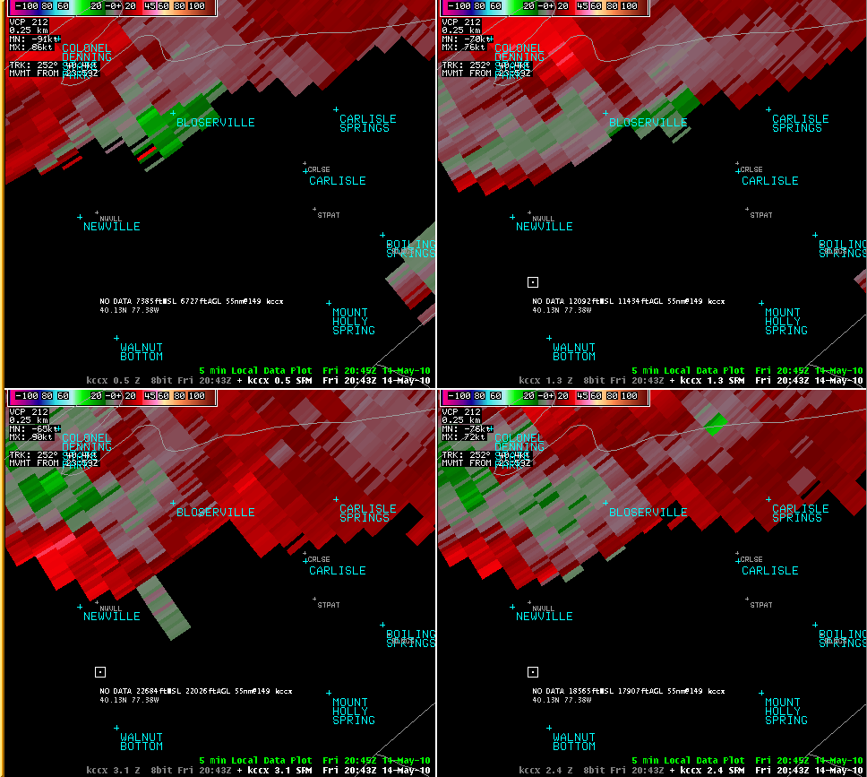
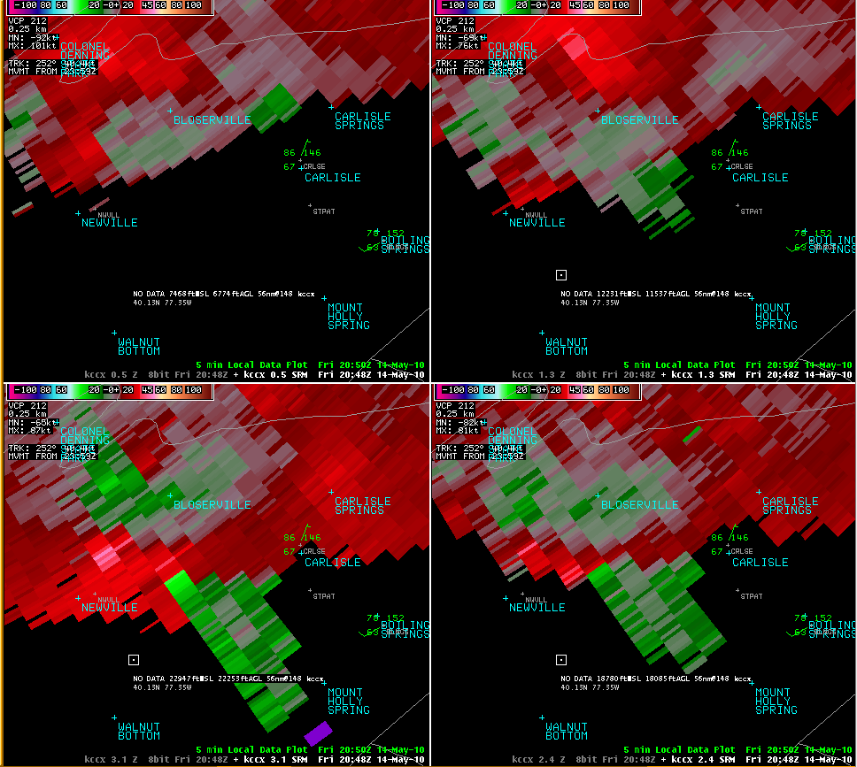
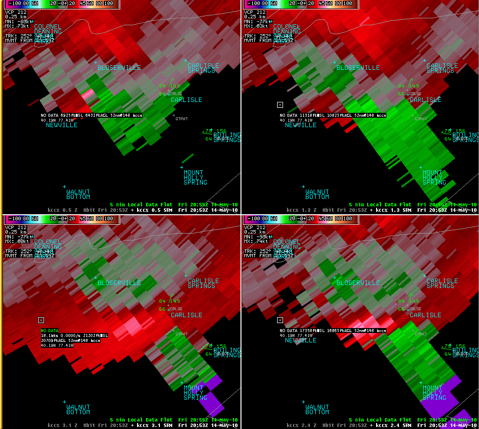
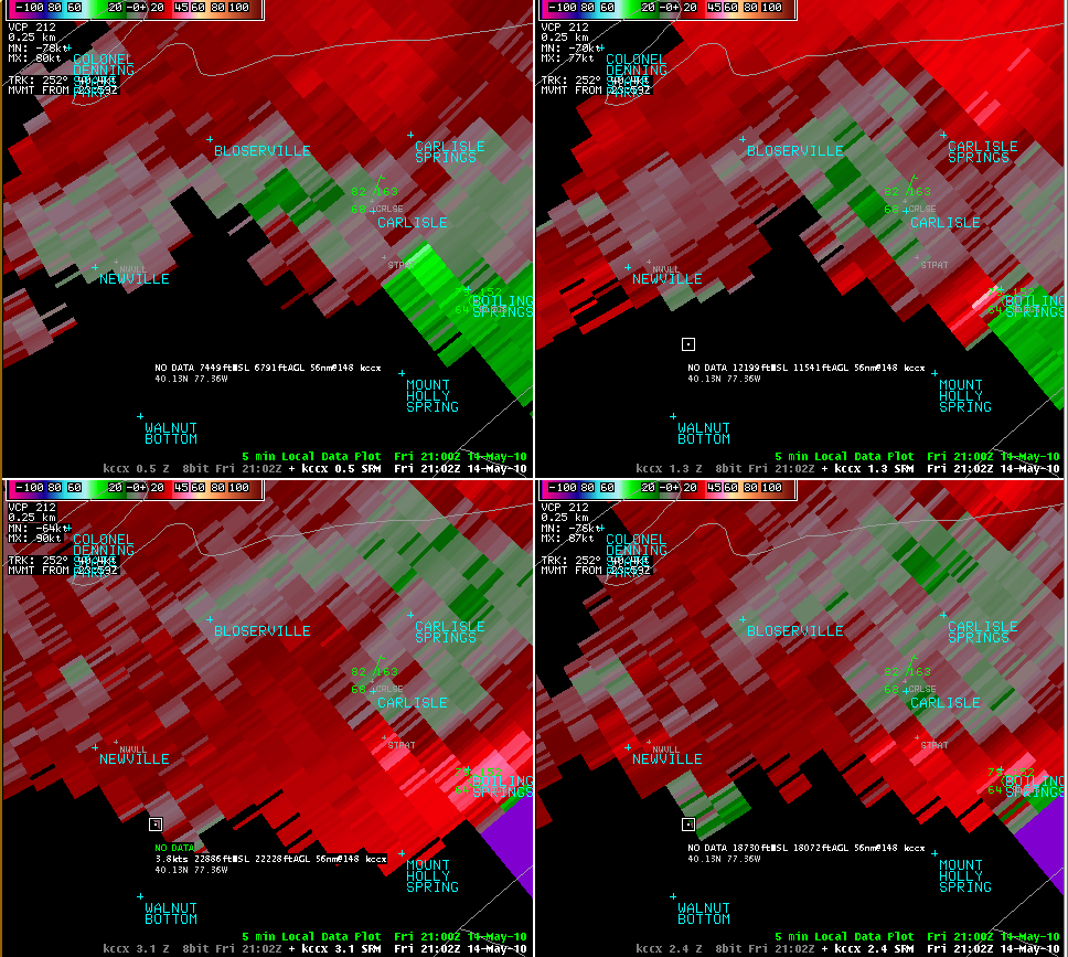
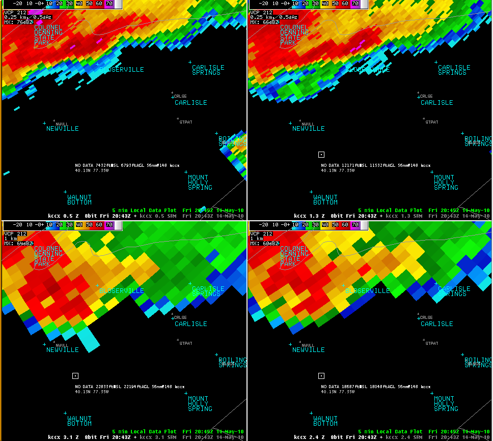
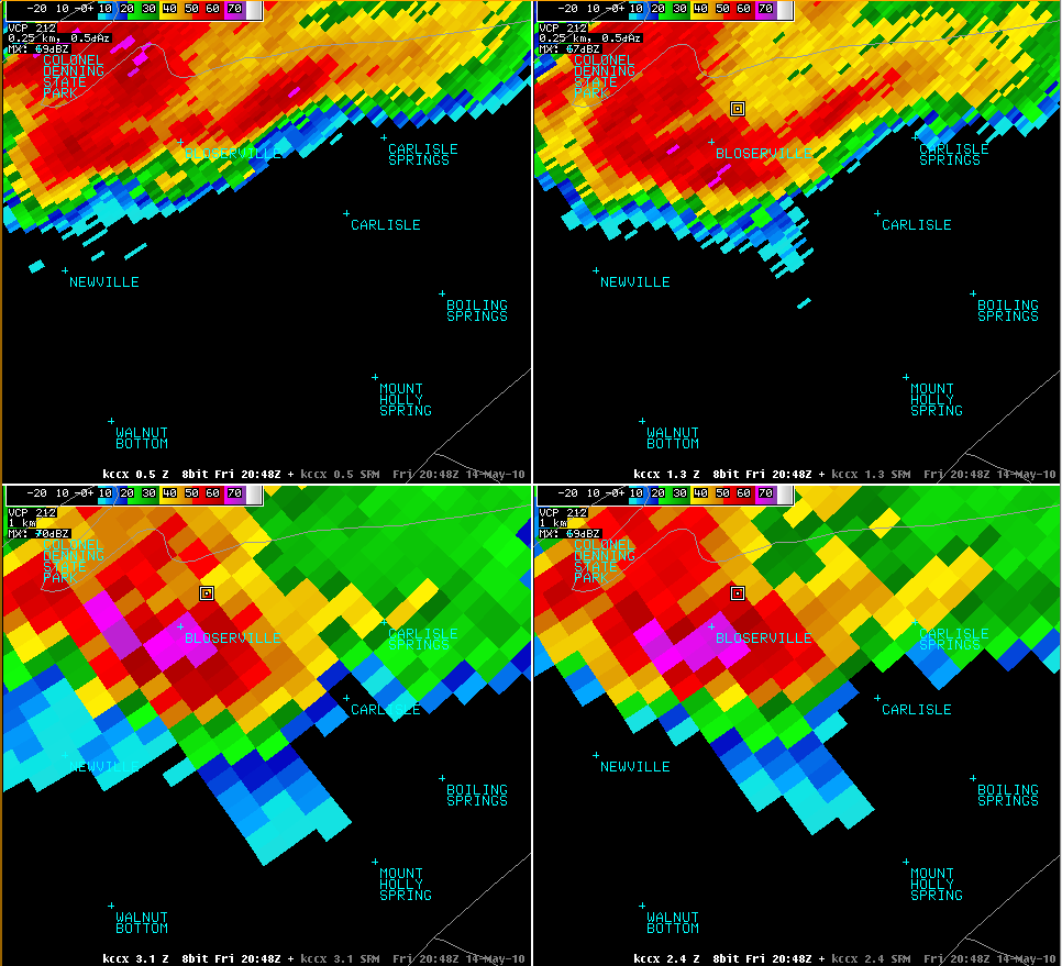
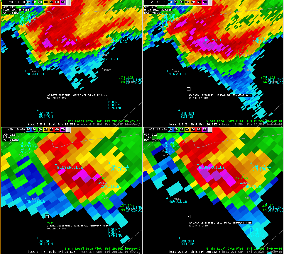
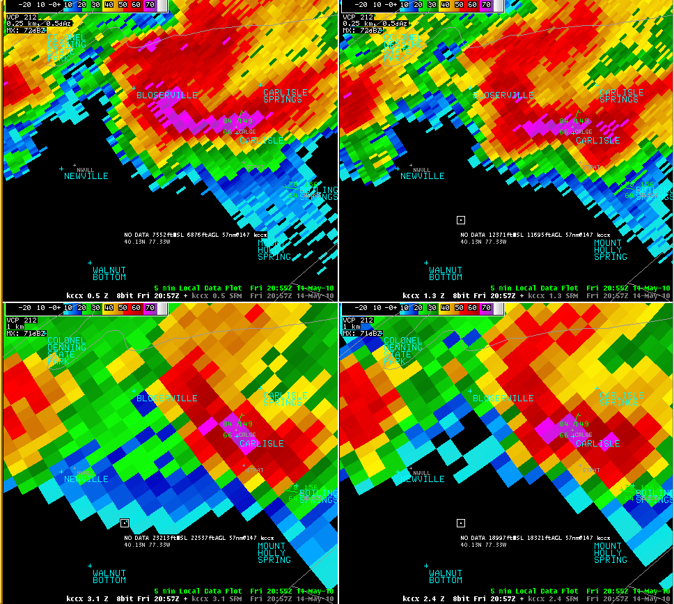
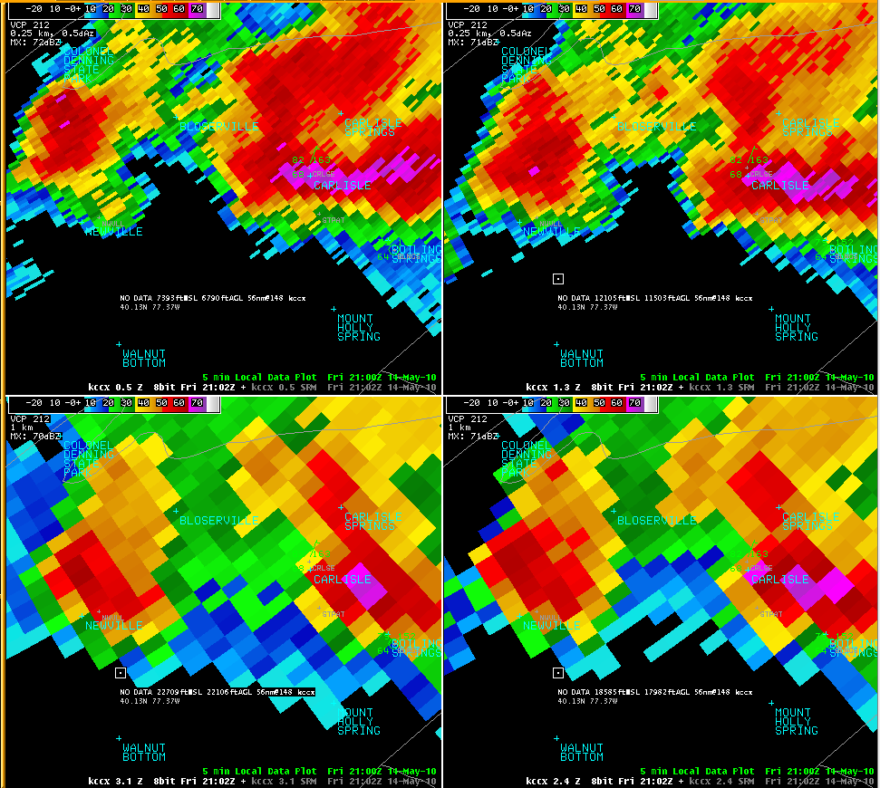
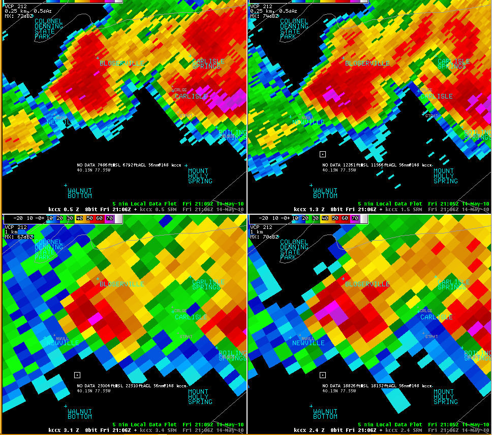
The storms produced lots of large hail and some wind damage. Most of the severe weather happened along and south of Route 22 between 3 PM and 8 PM. The storms fried up along a pre-frontal surface trough that had developed ahead of a cold front which was moving southward through PA during the afternoon and evening. Many of the storms exhibited low-level rotation, and had strong storm-top divergance - indicating strong updrafts and mesocyclones. Storm tops on this day over PA reached up to 50 kft at times, with most up to 40 kft. Steep mid-level lapse rates (the rate of cooling as you move up in elevation) and a freezing level around 11 kft provided a good set up for large hail. The worst storm of the bunch was a rotating supercell over Cumberland County. The storm moved through Carlisle about 5 PM, producing very large hail and some wind damge. The low-level rotation was so strong that a tornado warning was issued for central Cumberland County. See the reflectivity and storm-relative motion images from the KCCX 88D below. Inferring the storm structure from the reflectivity panels below, there is a (bounded) weak-echo region (BWER) over and just to the south of Bloserville. This is coincident with the best low to mid-level rotation on the SRM pics. These signatures pair up to indicate a strong, rotating updraft holding lots of water aloft. The area in the storm where the large hail is falling is most likely between Bloserville and Carlisle at 2053 UTC (453 PM EDT). There is a weak hook echo on the SW edge of the storm, which is most likely the base of the mesocyclone (the rotating updraft). A very noticable three-body scatter spike (hail flare) is visible extending SE out of the storm (away from the radar). This signature is another strong indication of a storm with lots of hail being held aloft. There is so much power reflected back to the radar in those radials that the radar has trouble specifying a distance and azimuth of the strong returns due to the hail stones themselves bouncing the radar energy around inside the storm core before returning it to the radar site. Hail of up to 2 inches was reported from this storm as it continued to move SE through northern York County and the western edge of Lancaster County. |
|
Radar
 |
 |
 |
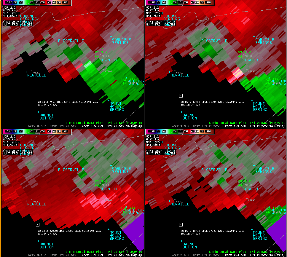 |
| Velocity 2043Z | Velocity 2048Z | Velocity 2053Z | Velocity 2057Z |
 |
 |
 |
 |
| Velocity 2102Z | Reflectivity 2043Z | Reflectivity 2048Z | Reflectivity 2053Z |
 |
 |
 |
| Reflectivity 2057Z | Reflectivity 2102Z | Reflectivity 2106Z |
Storm Reports
..TIME...   ...EVENT...      ...CITY LOCATION...     ...LAT.LON...
..DATE...   ....MAG....      ..COUNTY LOCATION..ST.. ...SOURCE....
            ..REMARKS..

0320 PM     TSTM WND DMG     5 SW ALTOONA            40.46N 78.47W
05/14/2010                   BLAIR              PA   COUNTY OFFICIAL

            911 CENTER REPORTED TREES DOWN AND POWER OUTAGES.

0345 PM     HAIL             GEISTOWN                40.29N 78.87W
05/14/2010  E1.75 INCH       CAMBRIA            PA   TRAINED SPOTTER

0347 PM     TSTM WND DMG     JOHNSTOWN               40.33N 78.92W
05/14/2010                   CAMBRIA            PA   NEWSPAPER

            TREES...LARGE LIMBS AND WIRES DOWN.

0355 PM     HAIL             ROARING SPRING          40.33N 78.40W
05/14/2010  M0.75 INCH       BLAIR              PA   TRAINED SPOTTER

0355 PM     TSTM WND DMG     1 N MARTINSBURG         40.32N 78.32W
05/14/2010                   BLAIR              PA   LAW ENFORCEMENT

            ROOF OFF HOUSE ON PINEY CR RD

0405 PM     TSTM WND GST     5 SW HUNTINGDON         40.45N 78.08W
05/14/2010  M85.00 MPH       HUNTINGDON         PA   PUBLIC

            WIND GUST RECORDED AT SEVEN POINTS VISITORS CENTER IN
            HESSTON.

0440 PM     HAIL             3 SW BOSWELL            40.13N 79.07W
05/14/2010  E0.75 INCH       SOMERSET           PA   TRAINED SPOTTER

            SPOTTER REPORTED PENNY SIZE HAIL COVERING GROUND.

0448 PM     HAIL             ELIZABETHVILLE          40.55N 76.82W
05/14/2010  M0.75 INCH       DAUPHIN            PA   TRAINED SPOTTER

0455 PM     HAIL             CARLISLE                40.20N 77.20W
05/14/2010  E1.00 INCH       CUMBERLAND         PA   PUBLIC

0456 PM     HAIL             CARLISLE                40.20N 77.20W
05/14/2010  E1.25 INCH       CUMBERLAND         PA   PUBLIC

0503 PM     HAIL             CARLISLE                40.20N 77.20W
05/14/2010  E1.25 INCH       CUMBERLAND         PA   PUBLIC

0504 PM     HAIL             CARLISLE                40.20N 77.20W
05/14/2010  E1.25 INCH       CUMBERLAND         PA   PUBLIC

0509 PM     HAIL             CARLISLE                40.20N 77.20W
05/14/2010  E1.75 INCH       CUMBERLAND         PA   PUBLIC

0510 PM     TSTM WND DMG     CARLISLE                40.20N 77.20W
05/14/2010                   CUMBERLAND         PA   PUBLIC

            TREES DOWN. POSSIBLE TORNADO - TRAIN-LIKE ROAR HEARD.

0510 PM     HAIL             MECHANICSBURG           40.21N 77.01W
05/14/2010  M1.75 INCH       CUMBERLAND         PA   TRAINED SPOTTER

0519 PM     HAIL             MECHANICSBURG           40.21N 77.01W
05/14/2010  E1.75 INCH       CUMBERLAND         PA   PUBLIC

0520 PM     HAIL             7 WSW CARLISLE          40.16N 77.33W
05/14/2010  E2.00 INCH       CUMBERLAND         PA   PUBLIC

            MOST OF THE HAIL WAS GOLF BALL SIZE WITH A FEW IN EXCESS
            OF 2 INCHES AT PLAINFIELD.

0540 PM     HAIL             2 WSW YORK HAVEN        40.10N 76.75W
05/14/2010  M1.00 INCH       YORK               PA   TRAINED SPOTTER

            SPOTTER REPORTED QUARTER SIZE HAIL AT STRINESTOWN.

0545 PM     HAIL             2 E MANCHESTER          40.06N 76.68W
05/14/2010  E2.00 INCH       YORK               PA   PUBLIC

            PUBLIC REPORT FROM MOUNT WOLF.

0545 PM     TSTM WND DMG     MANCHESTER              40.06N 76.72W
05/14/2010                   YORK               PA   NWS EMPLOYEE

            TREES AND WIRES DOWN 2 MILES WEST OF MOUNT WOLF.

0545 PM     HAIL             MANCHESTER              40.06N 76.72W
05/14/2010  E2.00 INCH       YORK               PA   PUBLIC

            REPORT FROM PEMA EMPLOYEE

0545 PM     HAIL             BAINBRIDGE              40.09N 76.67W
05/14/2010  M1.00 INCH       LANCASTER          PA   TRAINED SPOTTER

0550 PM     HAIL             MARIETTA                40.06N 76.55W
05/14/2010  M1.25 INCH       LANCASTER          PA   TRAINED SPOTTER

            GROUND COVERED BY QUARTER SIZE HAIL.

0552 PM     HAIL             WRIGHTSVILLE            40.02N 76.53W
05/14/2010  M1.75 INCH       YORK               PA   EMERGENCY MNGR

0555 PM     HAIL             WRIGHTSVILLE            40.02N 76.53W
05/14/2010  M1.00 INCH       YORK               PA   TRAINED SPOTTER

0557 PM     HAIL             MARIETTA                40.06N 76.55W
05/14/2010  M1.50 INCH       LANCASTER          PA   TRAINED SPOTTER

0600 PM     HAIL             COLUMBIA                40.03N 76.50W
05/14/2010  E0.88 INCH       LANCASTER          PA   PUBLIC

0600 PM     HAIL             5 N YORK                40.04N 76.73W
05/14/2010  M1.00 INCH       YORK               PA   TRAINED SPOTTER

0600 PM     TSTM WND GST     4 W CASHTOWN            39.88N 77.42W
05/14/2010  E60.00 MPH       ADAMS              PA   TRAINED SPOTTER

            PEA SIZE HAIL AND HEAVY RAINFALL.

0602 PM     HAIL             BAINBRIDGE              40.09N 76.67W
05/14/2010  M1.25 INCH       LANCASTER          PA   TRAINED SPOTTER

0605 PM     HAIL             MOUNTVILLE              40.04N 76.43W
05/14/2010  M1.00 INCH       LANCASTER          PA   TRAINED SPOTTER

0615 PM     HAIL             HALLAM                  40.00N 76.60W
05/14/2010  M1.75 INCH       YORK               PA   TRAINED SPOTTER

            CAR WINDSHEILD SMASHED.

0615 PM     HAIL             2 W LANCASTER           40.04N 76.34W
05/14/2010  M0.88 INCH       LANCASTER          PA   TRAINED SPOTTER

0615 PM     HAIL             2 NW ST. THOMAS         39.96N 77.77W
05/14/2010  M0.75 INCH       FRANKLIN           PA   TRAINED SPOTTER

            ESTIMATED 45 MPH WIND GUST.

0615 PM     HAIL             MILLERSVILLE            40.00N 76.35W
05/14/2010  M1.00 INCH       LANCASTER          PA   TRAINED SPOTTER

0615 PM     HAIL             SPRY                    39.91N 76.69W
05/14/2010  M0.88 INCH       YORK               PA   TRAINED SPOTTER

0620 PM     HAIL             DALLASTOWN              39.90N 76.64W
05/14/2010  M1.00 INCH       YORK               PA   TRAINED SPOTTER

            QUARTER SIZE HAIL AT HIGH SCHOOL.

0620 PM     HAIL             5 SE YORK               39.91N 76.67W
05/14/2010  M1.25 INCH       YORK               PA   TRAINED SPOTTER

0622 PM     HAIL             WINDSOR                 39.92N 76.58W
05/14/2010  E1.00 INCH       YORK               PA   TRAINED SPOTTER

0630 PM     HAIL             HANOVER                 39.81N 76.98W
05/14/2010  M0.88 INCH       YORK               PA   TRAINED SPOTTER

0645 PM     TSTM WND DMG     WAKEFIELD               39.76N 76.17W
05/14/2010                   LANCASTER          PA   EMERGENCY MNGR

            TREES AND WIRES DOWN. WIDESPREAD DAMAGE BETWEEN
            QUARRYVILLE AND WAKEFIELD.

0700 PM     HAIL             NEW FREEDOM             39.74N 76.70W
05/14/2010  M1.25 INCH       YORK               PA   TRAINED SPOTTER

0742 PM     HAIL             TYRONE                  40.68N 78.25W
05/14/2010  E1.25 INCH       BLAIR              PA   PUBLIC

0815 PM     TSTM WND DMG     PINE GROVE MILLS        40.74N 77.87W
05/14/2010                   CENTRE             PA   PUBLIC

            TREE 4 FEET IN DIAMETER DOWN. SHINGLES AND SIDING ON
            HOUSE DAMAGED. PEA SIZE HAIL. SEVERAL INCHES OF WATER ON
            ROADS.


&&
 |
Media use of NWS Web News Stories is encouraged! Please acknowledge the NWS as the source of any news information accessed from this site. |
 |