
Tropical moisture from Isaias and Rachel will impact portions of the Southeast and Southwest this weekend. Flash flooding, strong winds and even a threat for severe thunderstorms and tornadoes are possible. Meanwhile, strong winds and dry fuels are raising fire weather concerns across the central Great Basin and western High Plains. Across the northern Rockies, first winter storm of the season. Read More >
Overview
A cold front pushed through northwestern PA during the morning hours of Monday the 16th of August. The cold front reached Blue Mountain and the Middle Susquehanna Valley early in the afternoon. While very little rain fell over areas to the northwest of Harrisburg, thunderstorms developed and rapidly became severe during the afternoon hours.
The thunderstorms produced mainly wind damage, but some hail occurred as well. Flash Flooding occurred later that night, when the thunderstorms slowed and did not exit southern York and Lancaster Counties until after Midnight. Most of the residents of Central PA were able to see the tops of the thunderstorms that were producing the flooding, as the air behind the front was very dry -- allowing many to see the 100+ miles to the southeast. The tops of the thunderstorms and the lightning of them made quite a spectacular show. Residents of Central PA are not usually able to see for such long distances due to the haze (which gives Blue Mountain it's name) which usually hangs over the state.
A damage survey was conducted by the NWS and local Emergency Managers to investigate the possibility that a tornado caused damage in Central Lebanon County. Many residents and NWS-trained SkyWarnTM Spotters witnessed funnel clouds forming at the base of the thunderstorm that produced the damage. See the conclusions of the survey below.
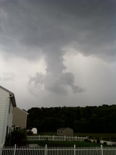 |
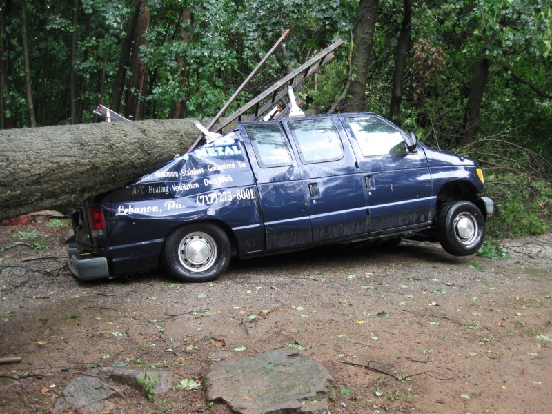 |
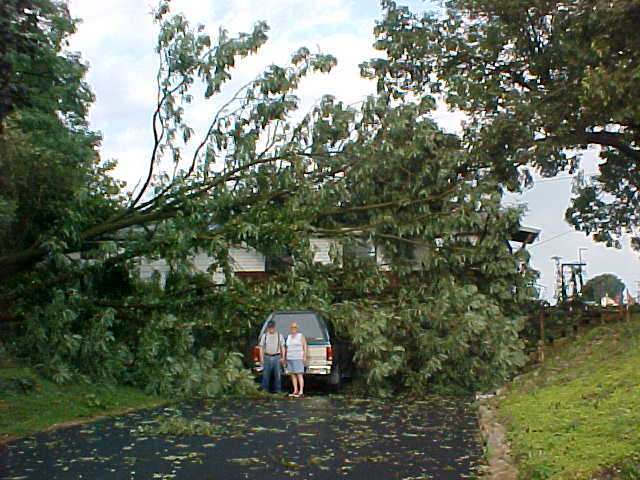 |
| Public photo of storm | Damage of crushed vehicle | Trees blown across driveway and homes |
Storm Damage Survey
PNSCTP
PAZ056>059-063>066-190030-
PUBLIC INFORMATION STATEMENT
NATIONAL WEATHER SERVICE STATE COLLEGE PA
429 PM EDT WED AUG 18 2010

...MICROBURST /STRAIGHT LINE WIND DAMAGE/ CONFIRMED NEAR
5 N LEBANON IN LEBANON COUNTY PENNSYLVANIA...

LOCATION...5 N LEBANON IN LEBANON COUNTY PENNSYLVANIA
DATE...08 16 2010
ESTIMATED TIME...420 PM EDT
ESTIMATED MAXIMUM WIND SPEED...70 MPH
MAXIMUM PATH WIDTH...400 YARDS
PATH LENGTH...1 MILE
BEGINNING LAT/LON...40.40974N/76.51742W
ENDING LAT/LON...40.39637N/76.41438W
* FATALITIES...0
* INJURIES...0

* THE INFORMATION IN THIS STATEMENT IS PRELIMINARY AND SUBJECT TO
CHANGE PENDING FINAL REVIEW OF THE EVENT(S) AND PUBLICATION IN NWS
STORM DATA.

...SUMMARY...
THE NATIONAL WEATHER SERVICE IN STATE COLLEGE PA HAS CONFIRMED A
MICROBURST /STRAIGHT LINE WIND DAMAGE/ JUST TO THE NORTH OF THE
CITY OF LEBANON AND SOUTH OF FREDERICKSBURG IN LEBANON COUNTY
PENNSYLVANIA ON AUGUST 16TH 2010.
A LONG BUT SPORADIC AREA OF TREE DAMAGE WAS SURVEYED BY NATIONAL
WEATHER SERVICE AND LEBANON COUNTY EMERGENCY MANAGEMENT PERSONNEL
TODAY.

THE MOST CONCENTRATED AREA OF DAMAGE WAS IN AND AROUND THE
FREEPORT MILLS GOLF COURSE...ALONG GOLF ROAD ABOUT 5 MILES NORTH
OF THE CITY OF LEBANON.

20 TO 30 TREES WERE EITHER UPROOTED OR SNAPPED. LOTS OF MINOR TREE
LIMB DAMAGE OCCURRED ACROSS A WIDER AREA WITH DAMAGE TO TREES
VISIBLE ALONG A PATH OF ABOUT 1 MILE. SOME MINOR CROP DAMAGE WAS
ALSO VISIBLE ALONG GOLF ROAD. THE OFFICE OF THE GOLF COURSE ALSO
HAD TWO STORM WINDOWS BLOW OFF AND LAND ACROSS THE ROAD. ONE TREE
LANDED ON A HOUSE ALONG FREEPORT ROAD AS WELL...BUT PRODUCED VERY
MINOR DAMAGE TO THE HOUSE.

EYEWITNESSES AT THE GOLF COURSE AND RESIDENTS ALONG ROAD VERIFIED
THE TIME OF OCCUR RANCE AROUND 420 PM.

AS MANY AS 5 RELIABLE WITNESSES...ALL OF THEM WERE TRAINED
SKYWARN SPOTTERS OR EMERGENCY RESPONDERS...VIEWED FUNNEL CLOUDS
DESCEND FROM THIS STORM. HOWEVER...NONE OF THESE WITNESSES WERE ABLE
TO SEE THE FUNNEL CLOUDS TOUCH THE GROUND. NO STORM DAMAGE IN THE
AREA COULD BE DEFINITIVELY ATTRIBUTABLE TO A TORNADO.
THIS INFORMATION CAN ALSO BE FOUND ON OUR WEBSITE AT
WEATHER.GOV/CTP.

FOR REFERENCE...
A MICROBURST IS A CONVECTIVE DOWNDRAFT WITH AN AFFECTED OUTFLOW AREA
OF LESS THAN 2 1/2 MILES WIDE AND PEAK WINDS LASTING LESS THAN
5 MINUTES. MICROBURSTS MAY INDUCE DANGEROUS HORIZONTAL/VERTICAL
WIND SHEARS...WHICH CAN ADVERSELY AFFECT AIRCRAFT PERFORMANCE AND
CAUSE PROPERTY DAMAGE. STRAIGHT-LINE WINDS ARE GENERALLY ANY WIND
THAT IS NOT ASSOCIATED WITH ROTATION...USED MAINLY TO DIFFERENTIATE
THEM FROM TORNADIC WINDS.

SAFETY MESSAGE...
REMEMBER THAT SEVERE THUNDERSTORMS PRODUCE DAMAGE. THE SAFEST
PLACE TO BE DURING A THUNDERSTORM IS INSIDE A STRONG BUILDING AWAY
FROM WINDOWS.
$$
Radar
 |
 |
 |
 |
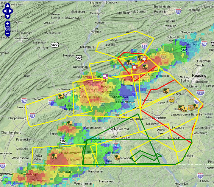
| 415 PM EDT Composite Reflectivity and all warnings overlaid The storm over Lebanon County was producing damage (reports at icons) |
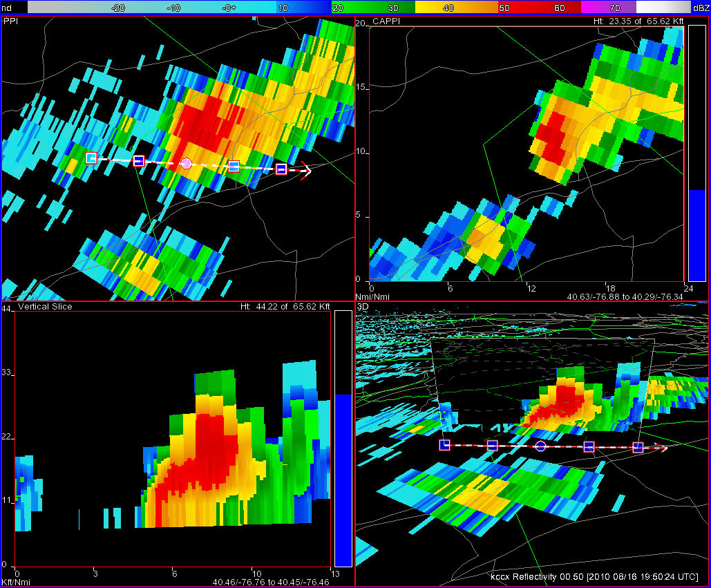
Four-panel view of storm over Northern Lebanon County at 350 PM EDT (top-left panel is 0.5deg reflectivity and location of cross section, bottom left is the reflectivity cross-section, top-right is reflectivity core at appx 24kft AGL, bottom-right is cross section overlaid onto 0.5deg reflectivity.) |
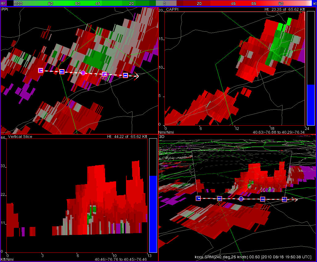
Four-panel Storm-Relative Motion view of storm over Northern Lebanon County at 350 PM EDT (Panels ordered as in above four-panel figure, showing Storm-Relative Motion output). |
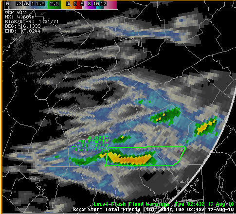
Storm Total Precipitation estimate from KCCX Radar Max amounts (over southern York County) were in excess of 4 inches |
Storm Reports
| Preliminary Damage Reports: |
LSRCTP

PRELIMINARY LOCAL STORM REPORT...CORRECTED
NATIONAL WEATHER SERVICE STATE COLLEGE PA
655 PM EDT TUE AUG 17 2010

..TIME...   ...EVENT...      ...CITY LOCATION...     ...LAT.LON...
..DATE...   ....MAG....      ..COUNTY LOCATION..ST.. ...SOURCE....
            ..REMARKS..

0345 PM     TSTM WND DMG     CARLISLE                40.20N 77.20W
08/16/2010                   CUMBERLAND         PA   EMERGENCY MNGR
            TREES AND WIRES DOWN NEAR CARLISLE.

0355 PM     TSTM WND DMG     1 ENE LICKDALE          40.47N 76.47W
08/16/2010                   LEBANON            PA   EMERGENCY MNGR
            1000 POUND PROPANE TANK AT A CHURCH CAMP ON MOUNTAIN
            DRIVE BLOWN OFF SUPPORTS AND DAMAGED/DISCHARGED. FIRE
            DEPARTMENT RESPONDED TO RESULTANT LEAK.

0405 PM     FUNNEL CLOUD     2 WSW JONESTOWN         40.40N 76.52W
08/16/2010                   LEBANON            PA   TRAINED SPOTTER
            FUNNEL CLOUD REPORTED JUST NORTHEAST OF ONO.

0405 PM     TSTM WND DMG     4 SSW GETTYSBURG        39.78N 77.26W
08/16/2010                   ADAMS              PA   EMERGENCY MNGR
            TREES AND WIRES DOWN IN GREENMOUNT.

0410 PM     FUNNEL CLOUD     FREDERICKSBURG          40.46N 76.43W
08/16/2010                   LEBANON            PA   TRAINED SPOTTER
            FUNNEL CLOUD OVER FREDRICKSBURG

0420 PM     TSTM WND DMG     5 N LEBANON             40.41N 76.42W
08/16/2010                   LEBANON            PA   PUBLIC
            30+ TREES UPROOTED/DOWNED AT FREEPORT MILLS GOLF COURSE.
            ALSO DAMAGE TO BARN AND TREES DOWN ON GOLF RD.

0430 PM     HAIL             LINGLESTOWN             40.34N 76.79W
08/16/2010  E1.00 INCH       DAUPHIN            PA   TRAINED SPOTTER
            QUARTER SIZE HAIL FELL NEAR LINGLESTOWN.

0510 PM     TSTM WND DMG     3 ENE BRICKERVILLE      40.24N 76.23W
08/16/2010                   LANCASTER          PA   EMERGENCY MNGR
            TREES AND WIRES DOWN IN CLAY TOWNSHIP.

0520 PM     TSTM WND GST     EPHRATA                 40.18N 76.18W
08/16/2010  M67.00 MPH       LANCASTER          PA   PUBLIC

0549 PM     TSTM WND DMG     1 N NEW HOLLAND         40.12N 76.09W
08/16/2010                   LANCASTER          PA   TRAINED SPOTTER
            LARGE TREES DOWN NEAR ROUTE 322 NORTH OF NEW HOLLAND.

0555 PM     TSTM WND DMG     2 ENE NEW HOLLAND       40.11N 76.06W
08/16/2010                   LANCASTER          PA   TRAINED SPOTTER
            PORTION OF ROOF BLOWN OFF A BUILDING INTO PARKING LOT AT
            THE INTERSECTION OF ROUTE 322 AND EWELL ROAD IN EAST EARL
            TOWNSHIP.

0555 PM     NON-TSTM WND DMG 3 WSW CHURCHTOWN        40.12N 76.00W
08/16/2010                   LANCASTER          PA   TRAINED SPOTTER
            TREES DOWN

0600 PM     TSTM WND DMG     1 SSW CHURCHTOWN        40.13N 75.96W
08/16/2010                   LANCASTER          PA   BROADCAST MEDIA
            NUMEROUS TREES AND WIRES DOWN AT THE INTERSECTION OF
            SOUTH POOL FORGE ROAD AND NARVON ROAD.

0755 PM     TSTM WND DMG     YORK SPRINGS            40.01N 77.12W
08/16/2010                   ADAMS              PA   EMERGENCY MNGR
            TREES AND WIRES DOWN IN YORK SPRINGS.

0930 PM     TSTM WND DMG     SHREWSBURY              39.77N 76.68W
08/16/2010                   YORK               PA   EMERGENCY MNGR
            LARGE TREES DOWN IN SHREWSBURY.
|
 |
Media use of NWS Web News Stories is encouraged! Please acknowledge the NWS as the source of any news information accessed from this site. |
|



 Radar
Radar Current Weather
 Rivers & Lakes
 Satellite
 Forecast Maps
 Hour by Hour Forecast
 Tropical Weather
 Graphical Hazards
 Weather Hazards Briefing
 Fire Weather
 Text Forecasts and Statements
 Forecaster's Discussion
 Send Us a Report
 KCCX Local Radar (Hi-Res)
 Drought
 Winter
 Follow us on X
 Follow us on Facebook
 CTP RSS Feed