Overview
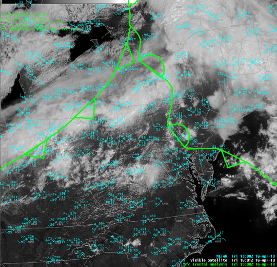
Central PA had it's second severe weather episode of the season (See the map of warnings and reports). The set up for the day was kind of obvious with a cold front coming down from the northwest in mid-April. But, this event also had a very dary airmass to run into. The biggest threat of the day was damaging straight-line wind gusts, and this did play out as the thunderstorms developed and moved very fast/quickly - to the east.
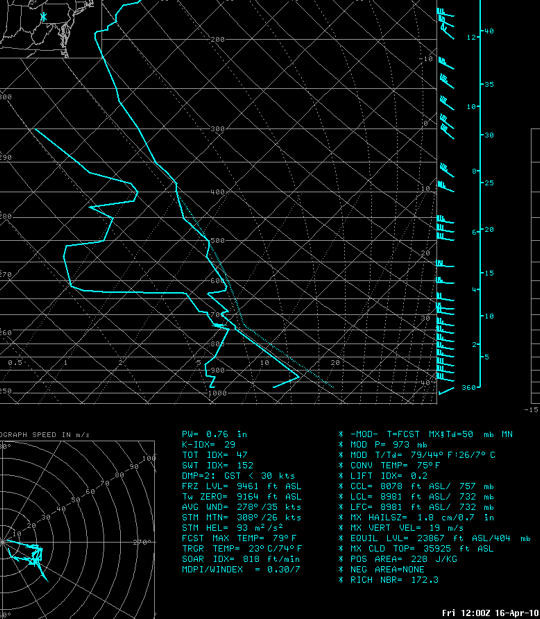
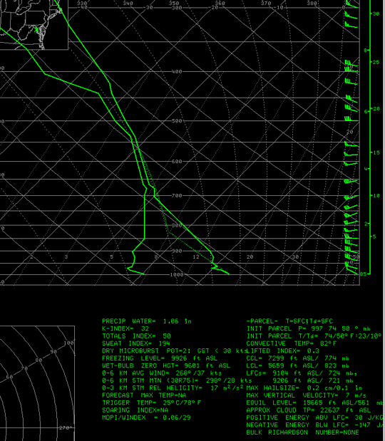
Winds Aloft were 45 to 50 Knots (50-60 MPH), as seen on the morning balloon sounding from Pittsburgh. The dry air at the surface is visible in the large temperature and dewpoint spread (lines far apart at the bottom of this plot (A Skew-T, Log P Diagram aka a SkewT). As the day went on, the temperatures warmed up further, and the moisture at the surface rose slightly ahead of the cold front. With the atmosphere becoming well-mixed (similar dewpoints but a steep change in temperature from the surface to the cloud base) the threat for damaging winds became larger - a situation commonly seen the Western U.S. The balloon sounding below is referred to as an "inverted V" sounding. These conditions make it very easy to bring the strong winds aloft down to the surface, and produce gust speeds similar in magnitude to the wind speed seen at the "peak" of the upside-down V. This is not a normal mode of the atmosphere in the Eastern States, since we usually have much more moisture in the low levels, and lower cloud bases than what we saw on the 16th.
The winds at 5 and 10 thousand feet on the 16th were between 50 and 60 MPH. So, as the thunderstorms got taller and taller, they developed stronger updrafts, and what goes up usually comes down (downdraft), it made it easier and easier for those winds to get to the surface.
The thunderstorms developed just after noon, and formed into small bow-echoes. The steering-level flow (aloft) moved them due west to east at 50 to 60 MPH. The gusts from those stroms made gusts as advertised, and produced lots of damage. Many reports of severe wind gusts were received during the late afternoon and early evening, with at least three ASOS (Automated Surface Observing Sites) reporting wind gusts over 60 MPH.
 |
 |
 |
| Surface Fronts and Visible Satellite with observations at 15Z (11AM EST) 16April2010 | Pittsburgh, PA Upper Air (balloon) Sounding from 12Z (8AM EST) 16April2010 | Washington, DC Upper Air (balloon) Sounding from 00Z 17April2010 (8PM EST 16April2010) |
 |
Media use of NWS Web News Stories is encouraged! Please acknowledge the NWS as the source of any news information accessed from this site. |
 |