Overview
|
Heavy rain fell across portions of south central Pennsylvania during the late afternoon and early evening hours of July 23, 2009. Slow moving thunderstorms moved across Cumberland and northern York counties dropping heavy rain. NWS State College storm total precipitation estimates from radar indicate that around 5.7 inches of rain fell around Bloserville and Carlisle Springs and 5.8 inches fell near Siddonsburg. |
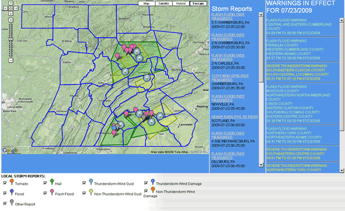 Storm Reports for July 23, 2009 |
Maps
 |
 |
 |
 |
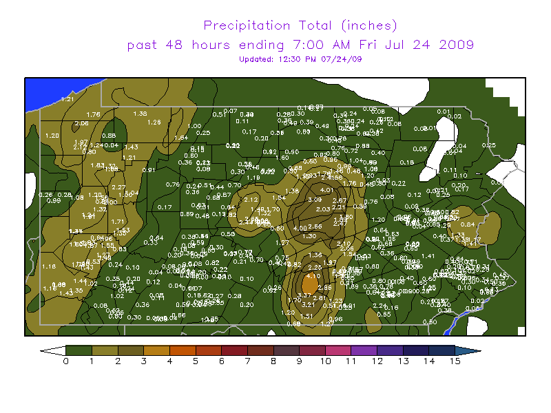
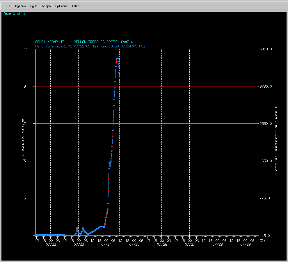
| COOP 2-Day precipitation amounts | Yellow Breeches Creek at Camp Hill river stage (Flood stage is 9 feet) |
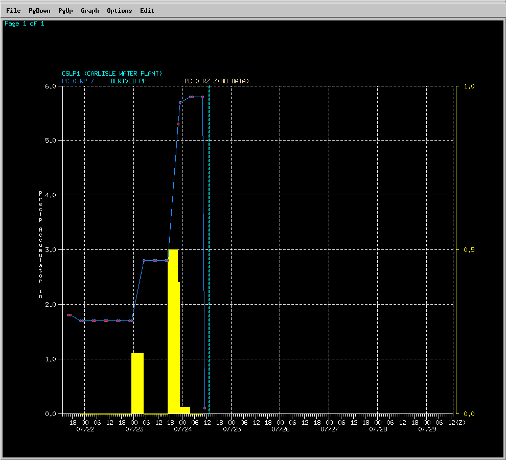
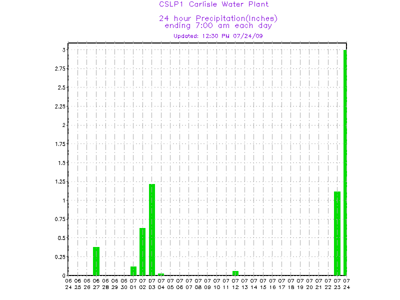
Carlisle Water Plant precipitation accumulation measuring around 4 inches of rain accumulation (starting at 1.8 inches to 5.8 inches) during the day | Carlise Water Plant rain gage readings for the past 30 days |
Radar
 |
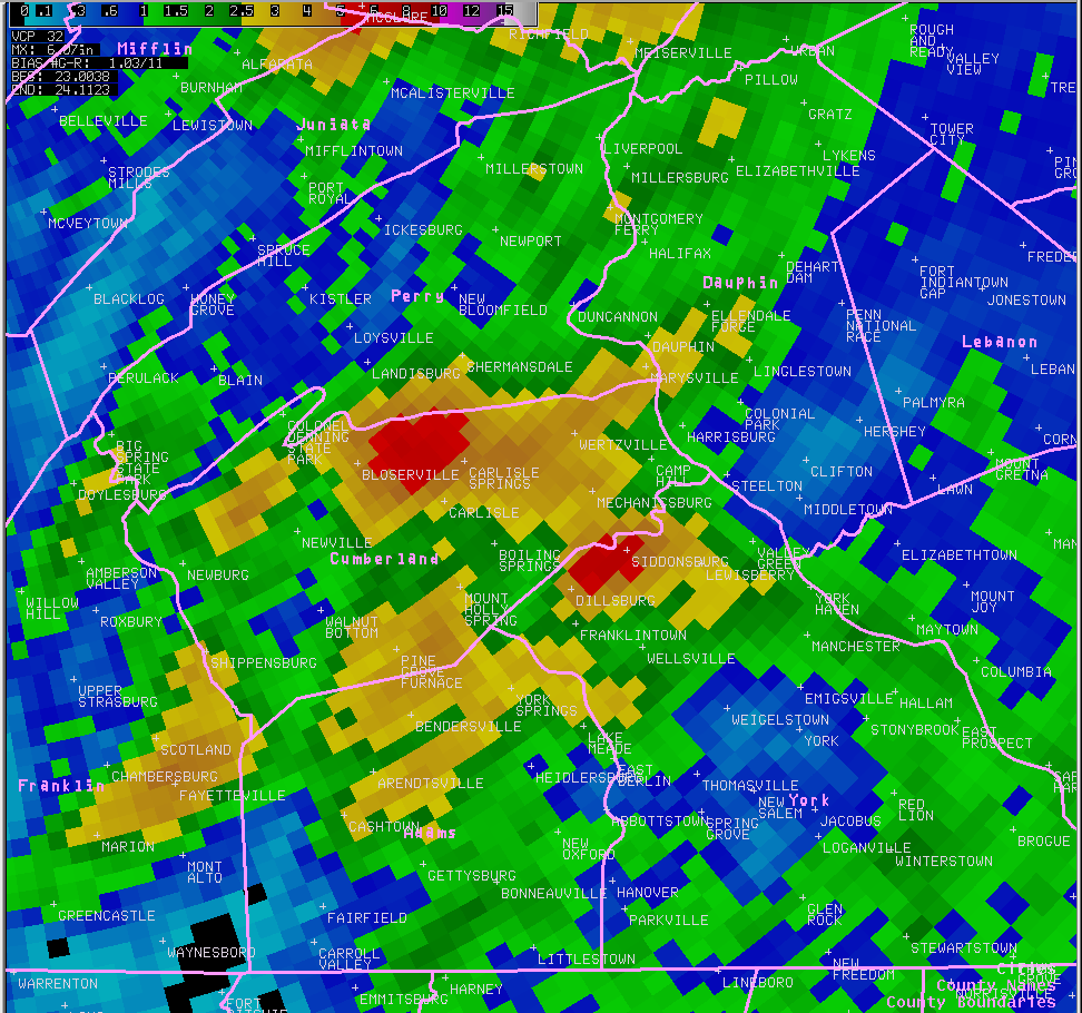 |
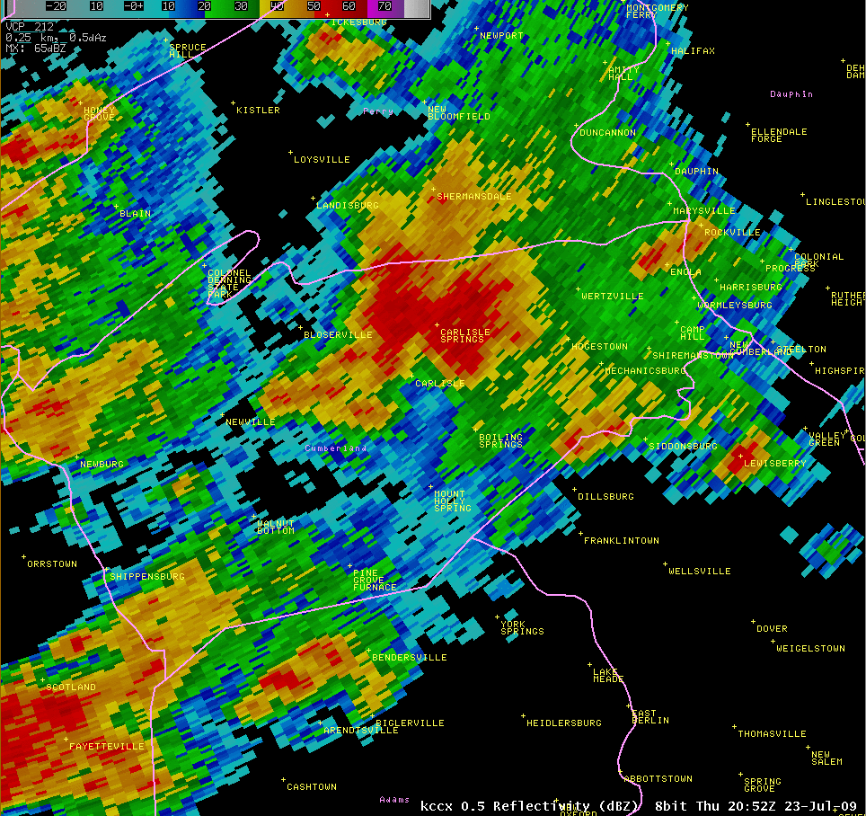
| KCCX Radar at 4:52 pm showing strong storms over northern Cumberland county | Storm Total Precipitation estimates showing heavy rain across Cumberland and northern York counties |
Storm Reports
PRELIMINARY LOCAL STORM REPORT...SUMMARY
NATIONAL WEATHER SERVICE STATE COLLEGE PA
1049 PM EDT THU JUL 23 2009

..TIME...   ...EVENT...      ...CITY LOCATION...     ...LAT.LON...
..DATE...   ....MAG....      ..COUNTY LOCATION..ST.. ...SOURCE....
            ..REMARKS..

0522 PM     FLASH FLOOD      5 S CHAMBERSBURG        39.86N 77.66W
07/23/2009                   FRANKLIN           PA   TRAINED SPOTTER

            FLOODING ON I-81 FROM MILE MARKER 10 TO MILE MARKER 13.
            ABOUT 4 INCHES OF WATER ON ROADWAY CAUSED TRAFFIC
            PROBLEMS.

0530 PM     FLASH FLOOD      2 N CARLISLE            40.23N 77.20W
07/23/2009                   CUMBERLAND         PA   TRAINED SPOTTER

            3 TO 5 FEET OF WATER AT SEVERAL DWELLINGS ON ECHO ROAD IN
            NORTH MIDDLETON TOWNSHIP. WATER OVER MAILBOXES.

0535 PM     TSTM WND DMG     CHAMBERSBURG            39.93N 77.66W
07/23/2009                   FRANKLIN           PA   TRAINED SPOTTER

            TREES AND POWER LINES DOWN IN AND AROUND CHAMBERSBURG.

0545 PM     FLASH FLOOD      NEWVILLE                40.17N 77.40W
07/23/2009                   CUMBERLAND         PA   TRAINED SPOTTER

            FLOODING ON I-76 /PA TURNPIKE/.

0600 PM     HEAVY RAIN       SCOTLAND                39.96N 77.59W
07/23/2009  M4.70 INCH       FRANKLIN           PA   TRAINED SPOTTER

            4.7 INCHES OF RAIN FELL BETWEEN 330 PM AND 6 PM.

0625 PM     FLASH FLOOD      4 SSE MECHANICSBURG     40.16N 76.98W
07/23/2009                   CUMBERLAND         PA   TRAINED SPOTTER

            SEVERAL RESIDENTS IN UPPER ALLEN TOWNSHIP NEEDED TO BE
            RESCUED FROM FLOODED HOMES.

0645 PM     FLASH FLOOD      2 NE DILLSBURG          40.13N 77.01W
07/23/2009                   YORK               PA   EMERGENCY MNGR

            WATER RESCUE AT GETTYSBURG PIKE AT CHESTNUT. WATER OVER
            HOOD OF CAR.

0645 PM     FLASH FLOOD      DILLSBURG               40.11N 77.03W
07/23/2009                   YORK               PA   EMERGENCY MNGR

            ROADS COVERED WITH WATER...MANY REPORTS BEGINNING AROUND
            645 PM. ADDITIONAL REPORTS FROM SIDDONSBURG AND
            SURROUNDING AREAS. MANY ROADS CLOSED.

0715 PM     FLASH FLOOD      AVIS                    41.19N 77.32W
07/23/2009                   CLINTON            PA   EMERGENCY MNGR

            MUD SLIDE ACROSS ROAD

0715 PM     FLASH FLOOD      7 N LOCK HAVEN          41.24N 77.45W
07/23/2009                   CLINTON            PA   EMERGENCY MNGR

            ROADWAY WASHING AWAY AT MIDDLE HILL ROAD AND COUDERSPORT
            PIKE.

0715 PM     FLASH FLOOD      4 W AVIS                41.19N 77.39W
07/23/2009                   CLINTON            PA   EMERGENCY MNGR

            CHATHAM RUN OUT OF ITS BANKS AT GRAVEL HILL RD

0715 PM     FLASH FLOOD      2 N BEECH CREEK         41.10N 77.59W
07/23/2009                   CLINTON            PA   EMERGENCY MNGR

            ROADS FLOODED

0720 PM     FLASH FLOOD      4 NNE JERSEY SHORE      41.25N 77.24W
07/23/2009                   LYCOMING           PA   EMERGENCY MNGR

            ROCK SLIDE ONTO ROUTE 973.

0720 PM     FLASH FLOOD      3 NNW JERSEY SHORE      41.24N 77.29W
07/23/2009                   LYCOMING           PA   EMERGENCY MNGR

            ROUTE 44 WASHED OUT.

0817 PM     HEAVY RAIN       DILLSBURG               40.11N 77.03W
07/23/2009  M3.64 INCH       YORK               PA   TRAINED SPOTTER

            RAIN SO FAR TODAY.

1040 PM     FLASH FLOOD      5 ENE SIDDONSBURG       40.18N 76.87W
07/23/2009                   YORK               PA   LAW ENFORCEMENT

            NEWLY FLOODED AND CLOSED ROADS IN FAIRVIEW TOWNSHIP.
            FLOODING ONGOING AS WELL.
 |
Media use of NWS Web News Stories is encouraged! Please acknowledge the NWS as the source of any news information accessed from this site. |
|


 Send Us a Report