State College, PA
Weather Forecast Office
Overview
|
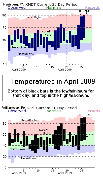
A mid-summer-like pattern allowed temperatures to soar for the last few days (April 25-27), and the unusually hot weather could linger one more day. The temperatures reached Record Highs at both Central PA First-Order Climatological Sites (Harrisburg and Williamsport) on Monday (the 27th). Harrisburg tied it's record maximum for the day at 92 degrees, which was last set in 1957. Williamsport broke the previous record of 92 (set in 1990) with a 94 degree reading. The 3 straight days of 90+ temperatures in Williamsport met the generally accepted definition of a "Heat Wave" in Central PA. Many locations across the Southern and Eastern portions of the State hit 90 degrees each of the last 3 days. While a cold front will push into the State from the northwest with showers and some thunderstorms on Tuesday, the morning and much of the afternoon on Tuesday will be rain-free to the south and east of State College (including Williamsport and Harrisburg). A general increase in moisture and cloud cover should keep the high temperatures on Tuesday in the 80s. But, some locations - especially in the Southeast - could touch 90 again. The Records and Normals for Central PA (including plots like the ones below) can be found on our Climate Page. |
 Caption |
 |
Media use of NWS Web News Stories is encouraged! Please acknowledge the NWS as the source of any news information accessed from this site. |
 |
US Dept of Commerce
National Oceanic and Atmospheric Administration
National Weather Service
State College, PA
328 Innovation Blvd, Suite 330
State College, PA 16803
(814)954-6440
Comments? Questions? Please Contact Us.


 Send Us a Report