
A Pacific storm system will continue to bring low elevation rain and mountain snow to much of the West through Wednesday, with heavy mountain snow expected in the higher elevations of the Sierra Nevada. This system will also bring strong winds to the Intermountain West, Rockies, and Plains, which will create Critical fire weather conditions for the High Plains. Read More >
Overview
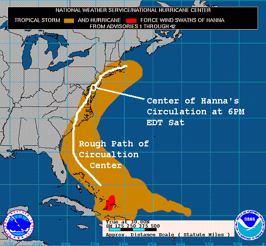
The remnants of once-Hurricane Hanna (which was a Tropical Storm for most of its life) moved up the Eastern Seaboard late Friday into Saturday (Sept 5-6), and produced rainfall over Southeastern Pennsylvania on Saturday, September 6th. While the rain reached almost 5 inches in spots, very little flooding occurred, and no river points in the NWS Central Pennsylvania Office's Hydrologic Service Area went even close to flood stage. The rainfall was mainly a constant, light to moderate rain over places along and to the Southeast of I- 83. The rain tapered off very quickly from east to west, with little or no rain occurring to the north or west of State College. (See Map of rainfall estimates below) The lack of flooding due to these seemingly high rain totals was mostly due to the fact that it had been very dry for the past few weeks, allowing the ground to soak up much of the rain, and keep run-off into the streams and waterways to a minimum.

Multi-Sensor Precipitation Estimate of Rainfall from Hanna
Wind Swath
Storm Reports
PUBLIC INFORMATION STATEMENT
SPOTTER REPORTS
NATIONAL WEATHER SERVICE STATE COLLEGE PA
1150 AM EDT SUN SEP 07 2008

THE FOLLOWING ARE UNOFFICIAL TWO-DAY STORM TOTAL RAINFALL
ACCUMULATIONS FROM THE REMNANTS OF TROPICAL STORM HANNA. THANKS TO
THE PUBLIC...COOP SPOTTERS AND EMERGENCY MANAGERS FOR THESE REPORTS.
THIS SUMMARY CAN ALSO BE FOUND ON OUR HOME PAGE AT
HTTP://WWW.NWS.NOAA.GOV/CTP

********************STORM TOTAL RAINFALL********************

LOCATION          STORM TOTAL    TIME/DATE    COMMENTS
                     RAINFALL       OF
                     (INCHES)   MEASUREMENT


PENNSYLVANIA

...ADAMS COUNTY...
   HANOVER               4.26   700 AM  9/7 COOP REPORT
   ABBOTTSTOWN 2N        3.59   700 AM  9/7 COCORAHS
   YORK SPRINGS 1SE      2.21   700 AM  9/7 COCORAHS

...DAUPHIN COUNTY...
   HERSHEY               2.88   700 AM  9/7 COOP REPORT
   HARRISBURG            2.61   700 AM  9/7 ASOS REPORT
   HARRISBURG 1NE        1.84   700 AM  9/7 COOP REPORT
   DEHART DAM            1.57   700 AM  9/7 COOP REPORT

...FRANKLIN COUNTY...
   SOUTH MOUNTAIN        1.70   700 AM  9/7 COOP REPORT
   GREENCASTLE           1.44   730 AM  9/7 COCORAHS
   UPPPER STRASBURG      1.00   700 AM  9/7 COOP REPORT

...HARFORD COUNTY...
   CONOWINGO DAM         3.38   700 AM  9/7 COOP REPORT

...LANCASTER COUNTY...
   SAFE HARBOR           4.54   700 AM  9/7 COOP REPORT
   TRUCE                 4.02   700 PM  9/6 COOP REPORT
   ELIZABETHTOWN 5WSW    3.50   800 AM  9/7 SPOTTER RPT
   LANCASTER             3.40   700 PM  9/6 PUBLIC RPT
   HOLTWOOD              3.29   700 AM  9/7 COOP REPORT
   COLUMBIA              3.16   600 PM  9/6 COOP REPORT
   GLEN MOORE            3.02   700 AM  9/7 COOP REPORT
   QUARRYVILLE           3.00   500 PM  9/6 PUBLIC RPT
   MOUNT JOY             2.40   700 PM  9/6 PUBLIC RPT
   NEW HOLLAND           2.18   700 AM  9/7 COOP REPORT

...LEBANON COUNTY...
   LEBANON 1S            2.13   700 AM  9/7 COCORAHS

...LYCOMING COUNTY...
   WILLIAMSPORT          1.06   700 AM  9/7 COOP REPORT

...MIFFLIN COUNTY...
   LEWISTOWN             1.08   700 AM  9/7 COOP REPORT

...PERRY COUNTY...
   MARYSVILLE 5WSW       1.59   700 AM  9/7 COCORAHS

...SCHUYLKILL COUNTY...
   KEFFERS               2.40   700 PM  9/6 PUBLIC RPT
   PINE GROVE            1.89   700 AM  9/7 COOP REPORT
   MAHANOY CITY          1.72   700 AM  9/7 COOP REPORT

...SNYDER COUNTY...
   SELINSGROVE           1.21   700 AM  9/7 COOP REPORT

...YORK COUNTY...
   SPRING GROVE          5.01  1100 PM  9/6 PUBLIC RPT
   LOGANVILLE            3.70   600 PM  9/6 PUBLIC RPT
   YORK AIRPORT          3.64   800 PM  9/6 ASOS REPORT
   BLOOMING GROVE        3.49   600 PM  9/6 COOP REPORT
   INDIAN ROCK DAM       3.17   600 PM  9/6 COOP REPORT
   YORK HAVEN            3.11   700 AM  9/7 COOP REPORT
   DILLSBURG             2.15   700 PM  9/6 PUBLIC RPT

$$
 |
Media use of NWS Web News Stories is encouraged! Please acknowledge the NWS as the source of any news information accessed from this site. |
|


 Send Us a Report