
A storm system near the Hawaiian Islands is expected to bring periods of heavy rainfall, strong winds, and isolated strong to severe thunderstorms through Friday. Several rounds of severe thunderstorms are forecast to impact parts of the Great Plains into the Midwest this weekend into next week. Moderate to heavy rainfall and high elevation snow is expected this weekend over California and Oregon. Read More >
Overview
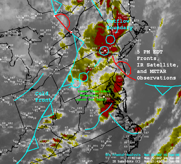
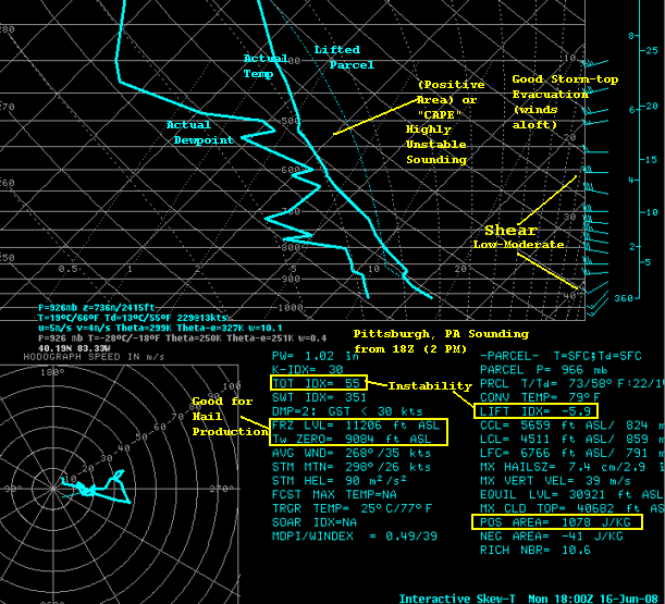
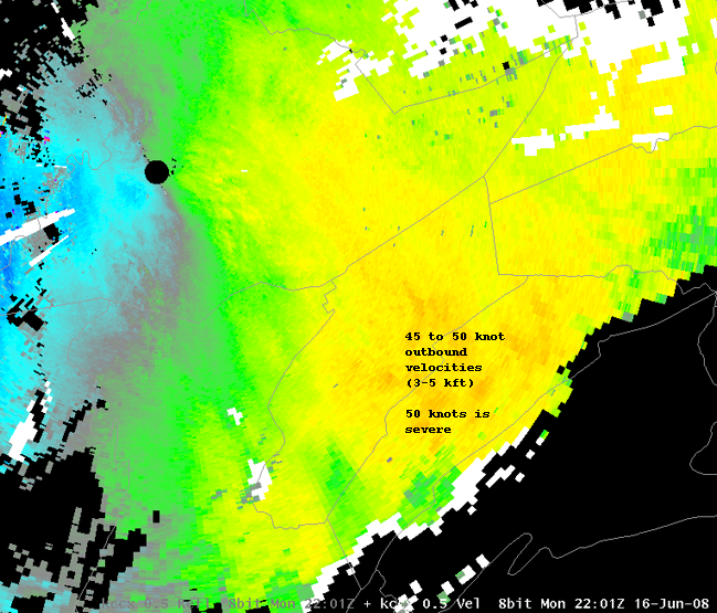
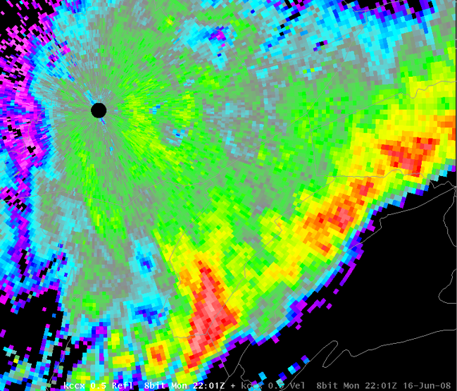
Strong June sunshine and a strong cold front combined to create showers and thunderstroms on Monday, June 16th, 2008. The conditions were favorable for hail and wind gusts. A few supercell storms formed, and most of those produced large hail. A few wind damage reports have been received, with the most from a long-duration bow echo that moved southeastward through Mifflin and Juniata counties. Many locations received two or three thunderstorms during the afternoon and evening. The cold front was the leading edge of much cooler and drier air that was a significant pattern change from the abnormally warm (hot) first half of June.
 |
 |
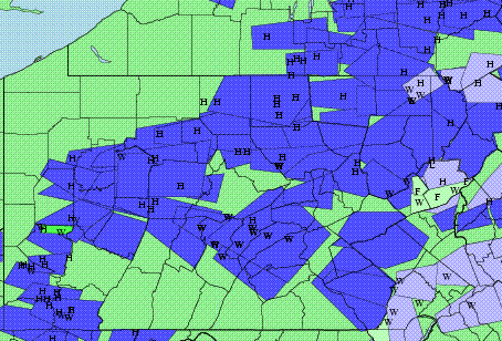 |
| Satellite, Fronts, and Observations at 5 PM EDT | Pittsburgh Special 18Z (2 PM) Balloon Sounding | Preliminary plot of warnings and storm reports for June 16th, 2008 |
 |
||
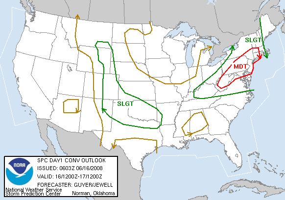
| There was a Moderate Risk of Severe Thunderstorms on June 16th, 2008 |
Radar
 |
 |
 |
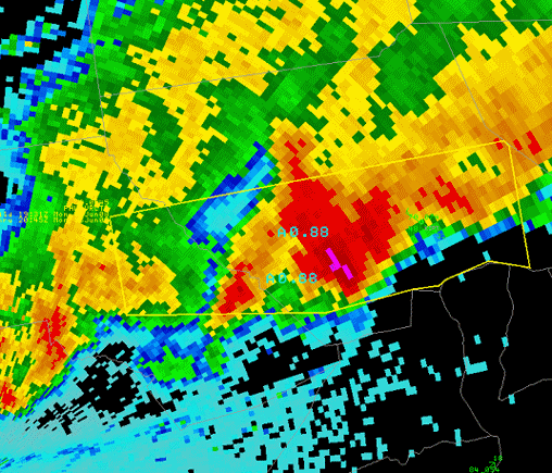 |
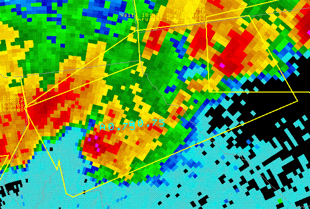
| Bow echo (base velocity) in central mountains | Bow echo (base reflectivity) in central mountains | Storm that produced hail in Renovo area around 3 PM. | Storm that did damage and produced hail in Jersey Shore and Williamsport area around 4 PM. |
Storm Reports
LSRCTP
PRELIMINARY LOCAL STORM REPORT...SUMMARY
NATIONAL WEATHER SERVICE STATE COLLEGE PA
601 AM EDT TUE JUN 17 2008
..TIME...   ...EVENT...      ...CITY LOCATION...     ...LAT.LON...
..DATE...   ....MAG....      ..COUNTY LOCATION..ST.. ...SOURCE....
            ..REMARKS..
0149 PM     HAIL             WELLSBORO               41.75N 77.30W
06/16/2008  U1.00 INCH       TIOGA              PA   PUBLIC
            1.00 INCH HAIL IN WELLSBORO
0204 PM     HAIL             4 N WELLSBORO           41.80N 77.30W
06/16/2008  E0.88 INCH       TIOGA              PA   PUBLIC
            NICKEL SIZE HAIL SOUTH OF MIDDLEBURY CENTER
0205 PM     HAIL             7 S WILCOX              41.48N 78.68W
06/16/2008  E1.00 INCH       ELK                PA   PUBLIC
            1.00 INCH HAIL IN GLEN HAZEL
0208 PM     HAIL             10 S BLOSSBURG          41.54N 77.07W
06/16/2008  E0.88 INCH       LYCOMING           PA   EMERGENCY MNGR
            NICKEL SIZE HAIL IN LIBERTY
0234 PM     HAIL             MORRIS                  41.65N 77.27W
06/16/2008  E0.88 INCH       TIOGA              PA   PUBLIC
            NICKEL SIZE HAIL IN MORRIS
0245 PM     HAIL             MANSFIELD               41.81N 77.08W
06/16/2008  E1.00 INCH       TIOGA              PA   PUBLIC
            1.00 INCH HAIL IN MANSFIELD
0310 PM     HAIL             RENOVO                  41.33N 77.75W
06/16/2008  M0.75 INCH       CLINTON            PA   EMERGENCY MNGR
            PENNY SIZE HAIL COVERING GROUND IN RENOVO
0311 PM     HAIL             5 E RENOVO              41.33N 77.65W
06/16/2008  E0.75 INCH       CLINTON            PA   PUBLIC
            HAIL AT NORTH BEND.
0350 PM     HAIL             SALLADASBURG            41.28N 77.23W
06/16/2008  E0.88 INCH       LYCOMING           PA   EMERGENCY MNGR
0355 PM     TSTM WND DMG     JERSEY SHORE            41.20N 77.27W
06/16/2008                   LYCOMING           PA   EMERGENCY MNGR
            EMA REPORTED TREES AND WIRES DOWN.
0400 PM     HAIL             JERSEY SHORE            41.20N 77.27W
06/16/2008  M0.88 INCH       LYCOMING           PA   TRAINED SPOTTER
0405 PM     HAIL             BURNSIDE                40.81N 78.79W
06/16/2008  E0.75 INCH       CLEARFIELD         PA   PUBLIC
            HAIL ACCUMULATION OF 2 INCHES ON GROUND.
0405 PM     HAIL             CLEARFIELD              41.02N 78.44W
06/16/2008  M1.00 INCH       CLEARFIELD         PA   TRAINED SPOTTER
0423 PM     HAIL             MAHAFFEY                40.88N 78.73W
06/16/2008  E0.75 INCH       CLEARFIELD         PA   PUBLIC
0435 PM     HAIL             3 NE BENTON             41.23N 76.34W
06/16/2008  M0.75 INCH       COLUMBIA           PA   CO-OP OBSERVER
0441 PM     HAIL             STILLWATER              41.15N 76.37W
06/16/2008  E0.88 INCH       COLUMBIA           PA   PUBLIC
0457 PM     TSTM WND DMG     4 SE TYRONE             40.64N 78.19W
06/16/2008                   BLAIR              PA   COUNTY OFFICIAL
            911 CENTER REPORTED WIRES DOWN IN BIRMINGHAM.
0510 PM     TSTM WND DMG     PINE GROVE MILLS        40.74N 77.87W
06/16/2008                   CENTRE             PA   COUNTY OFFICIAL
            911 CENTER REPORTED TREES AND WIRES DOWN.
0530 PM     TSTM WND DMG     YEAGERTOWN              40.64N 77.58W
06/16/2008                   MIFFLIN            PA   COUNTY OFFICIAL
            911 CENTER REPORTED TREE DOWN.
0530 PM     TSTM WND DMG     MCVEYTOWN               40.50N 77.74W
06/16/2008                   MIFFLIN            PA   COUNTY OFFICIAL
            911 CENTER REPORTED TREE DOWN IN OLIVER TOWNSHIP.
0530 PM     HAIL             MILROY                  40.71N 77.59W
06/16/2008  E0.75 INCH       MIFFLIN            PA   COUNTY OFFICIAL
            911 CENTER REPORTED LARGE HAIL.
0530 PM     TSTM WND DMG     LEWISTOWN               40.60N 77.57W
06/16/2008                   MIFFLIN            PA   COUNTY OFFICIAL
            911 CENTER REPORTED TREE DOWN ON ROUTE 322.
0540 PM     TSTM WND DMG     1 W HUNTINGDON          40.50N 78.03W
06/16/2008                   HUNTINGDON         PA   COUNTY OFFICIAL
            911 CENTER REPORTED TREE DOWN ON ROADWAY.
0540 PM     HAIL             ROULETTE                41.77N 78.16W
06/16/2008  M1.00 INCH       POTTER             PA   EMERGENCY MNGR
            LARGE HAIL FELL FOR 8 TO 10 MINUTES.
0545 PM     HAIL             COUDERSPORT             41.77N 78.01W
06/16/2008  M0.88 INCH       POTTER             PA   EMERGENCY MNGR
0545 PM     TSTM WND DMG     MILLERSTOWN             40.55N 77.15W
06/16/2008                   PERRY              PA   COUNTY OFFICIAL
            911 CENTER REPORTED TREES AND WIRES DOWN.
0545 PM     TSTM WND DMG     MIFFLIN                 40.57N 77.40W
06/16/2008                   JUNIATA            PA   COUNTY OFFICIAL
            911 CENTER REPORTED POWER POLE AND WIRES DOWN.
0555 PM     HAIL             EMPORIUM                41.51N 78.24W
06/16/2008  M0.75 INCH       CAMERON            PA   TRAINED SPOTTER
0600 PM     HAIL             LAWRENCEVILLE           42.00N 77.13W
06/16/2008  E0.88 INCH       TIOGA              PA   COUNTY OFFICIAL
            911 CENTER REPORTED LARGE HAIL.
0600 PM     TSTM WND DMG     MAPLETON                40.39N 77.94W
06/16/2008                   HUNTINGDON         PA   COUNTY OFFICIAL
            911 CENTER REPORTED TREE DOWN ON ROADWAY.
0625 PM     HAIL             BROCKPORT               41.27N 78.73W
06/16/2008  E1.00 INCH       ELK                PA   PUBLIC
0703 PM     HAIL             LEWISBERRY              40.14N 76.86W
06/16/2008  E0.75 INCH       YORK               PA   PUBLIC

&&
$$
 |
Media use of NWS Web News Stories is encouraged! Please acknowledge the NWS as the source of any news information accessed from this site. |
 |