
Widespread life-threatening flash and urban flooding continues in south-central Texas, with considerable flooding impacts possible across central Texas. Wildfire smoke is impacting air quality across much of the Great Lakes region into southern New England and the Mid-Atlantic. Monsoonal thunderstorms may produce isolated to scattered flash flooding across the Southwest into the Great Basin. Read More >
State College, PA
Weather Forecast Office
Overview
|
Showers and thunderstorms rolled across Central PA during the afternoon and evening of Tuesday May 27th, as a cold front moved through from north to south. The storms were generally weak, but one storm managed to make some wind damage in Lebanon County. See the radar picture around the time of the tree damage report below. If no more severe weather occurs before the end of the day this Saturday (5/31), this will be the only severe storm in Central PA during all of the month of May 2008. It is very unusual to have just one severe event in any May. |
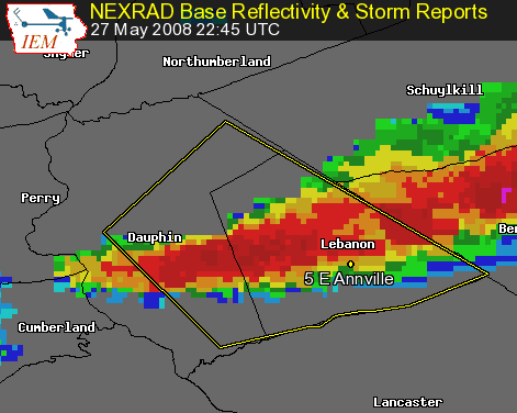 Base Reflectivity around the time of tree damage in Lebanon County 5/27/08 |
 |
Media use of NWS Web News Stories is encouraged! Please acknowledge the NWS as the source of any news information accessed from this site. |
|
US Dept of Commerce
National Oceanic and Atmospheric Administration
National Weather Service
State College, PA
328 Innovation Blvd, Suite 330
State College, PA 16803
(814)954-6440
Comments? Questions? Please Contact Us.


 Send Us a Report