
These storm systems will bring late season snow, sleet and ice for portions of the northern Plains, upper Midwest and Great Lakes region. Meanwhile, where temperatures are warmer, severe thunderstorms are expected for areas of the Mississippi Valley into the southern Plains. Furthermore, combination of windy and dry conditions will raise fire weather concerns for the southern High Plains. Read More >
Overview
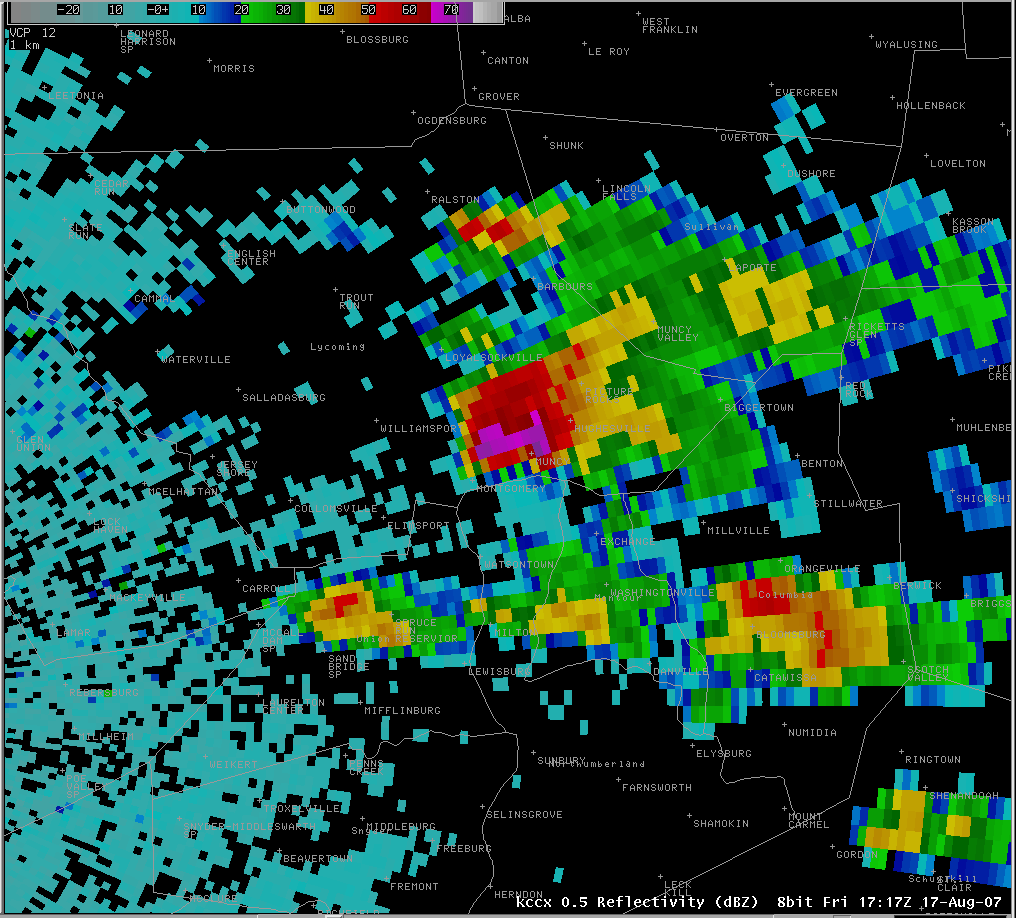
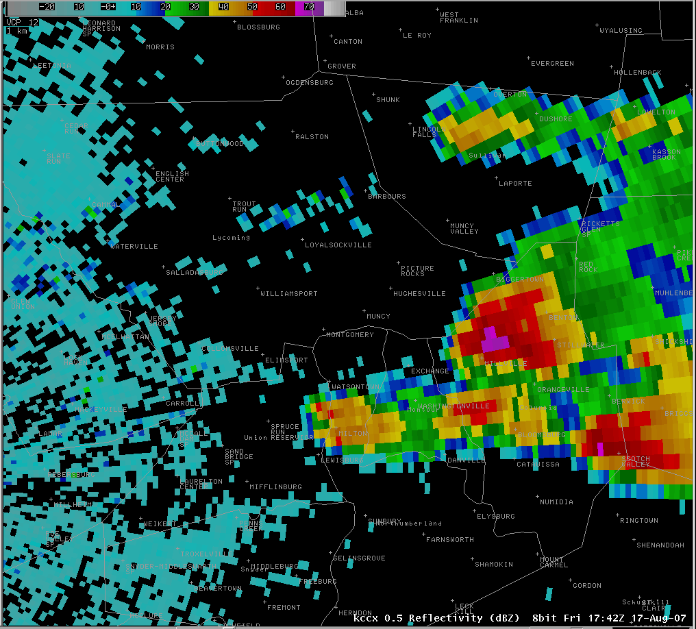
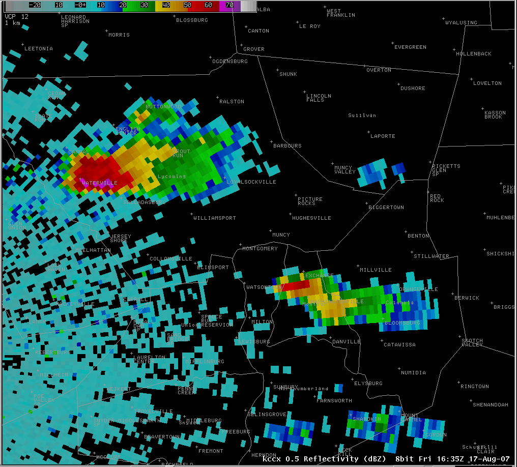
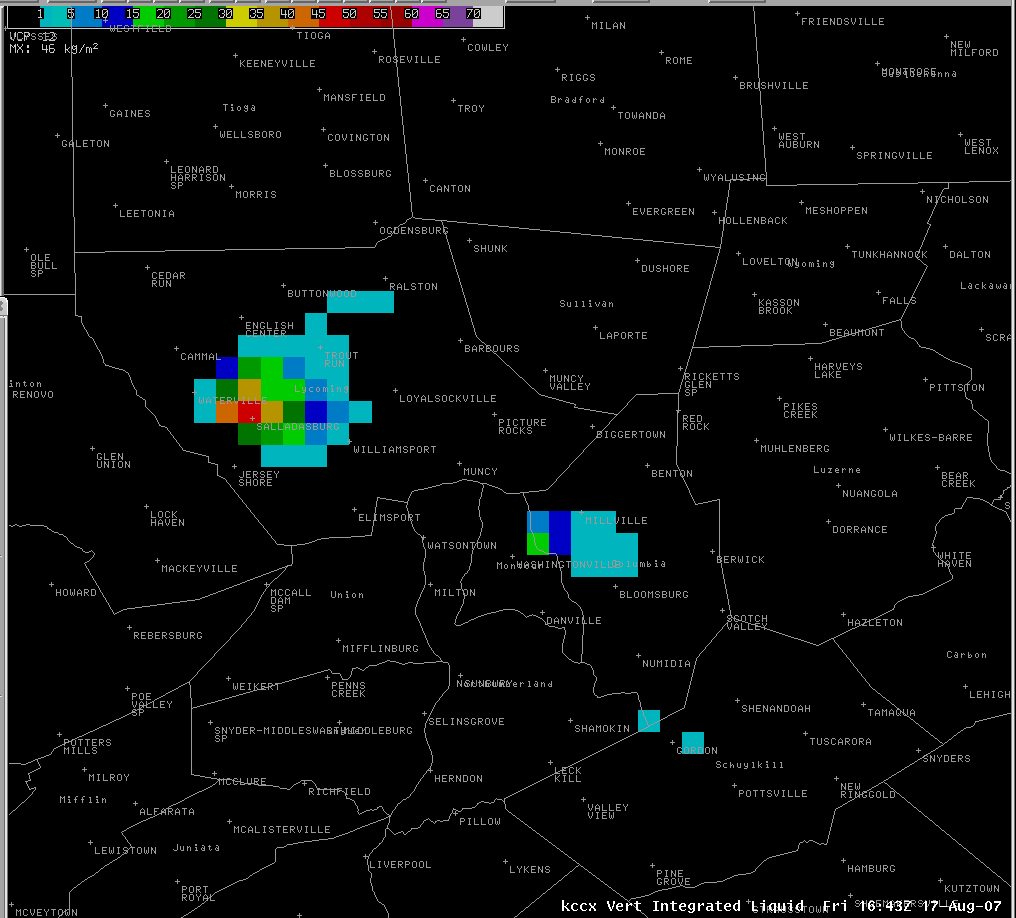
A significant hailstorm moved through Lycoming, Northumberland, and Columbia counties on August 17th, 2007 producing hail stones as large as 1.75 inches in diameter in Muncy. Golfball to baseball sized hail fell during the afternoon as a severe thunderstorm moved southeast across southern Lycoming county toward Columbia county from about 12:30 pm until 2:00 pm.
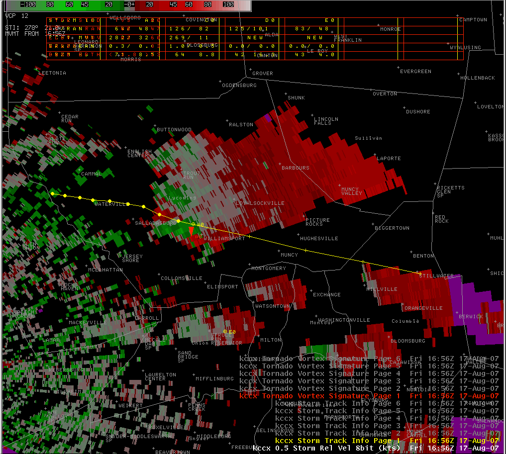
The storm was strong enough to produce rotation in the mid and upper levels of the atmosphere prompting a tornado warning for Lycoming county at 12:56 pm. Although there were some unconfirmed funnels reported by the public, an NWS State College survey team concluded there was no evidence of a tornado touching down.
In Muncy the storm's large hail shattered windows and damaged windshields. Strong straight-line winds also blew down large trees in Millville in northwest Columbia county disrupting power to about 800 PPL customers.
 |
 |
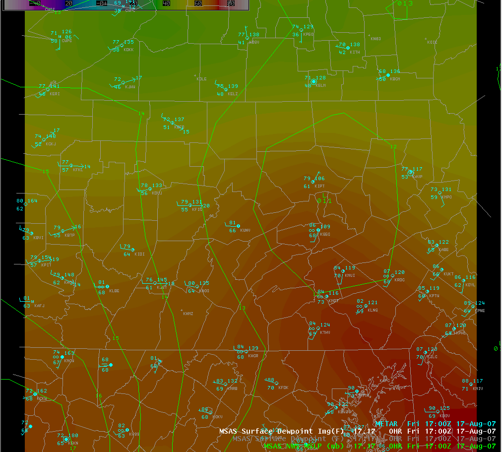 |
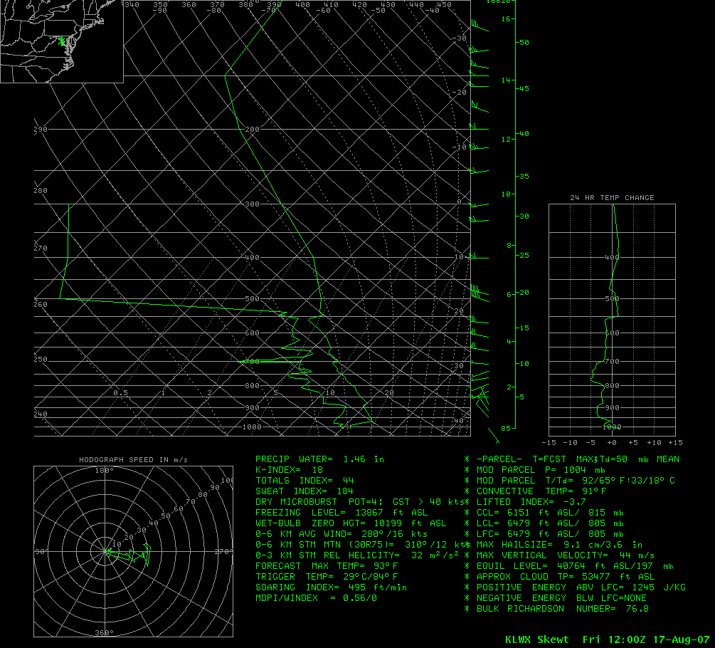
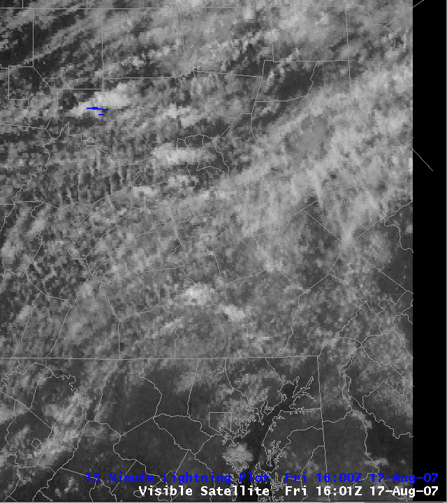
| Sterling, VA upper air sounding showing 1245 J/Kg of CAPE Friday morning | Visible Satellite loop from 12:00 to 2:30 pm | Surface analysis 1:00 pm showing low pressure and high dewpoints over the area |
Radar
 |
 |
 |
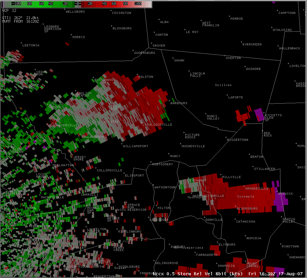 |
| KCCX Radar reflectivity showing storm over Muncy at 1:17 pm | KCCX Radar reflectivity showing storm over Millville at 1:42 pm | KCCX Radar showing rotation, Tornado Vortex Signature, and forecast Storm Track at 12:56 pm | KCCX Storm Relative Velocity loop 12:39 to 1:55 pm |
 |
 |
||
| KCCX Radar Reflectivity loop from 12:35 to 1:51 pm | KCCX Vertical Integrated Liquid loop from 12:43 to 1:42 pm |
Storm Reports
NWUS51 KCTP 200226
LSRCTP

PRELIMINARY LOCAL STORM REPORT...SUMMARY
NATIONAL WEATHER SERVICE STATE COLLEGE PA
1026 PM EDT SUN AUG 19 2007

..TIME...   ...EVENT...      ...CITY LOCATION...     ...LAT.LON...
..DATE...   ....MAG....      ..COUNTY LOCATION..ST.. ...SOURCE....
            ..REMARKS..

0100 PM     HAIL             1 W WILLIAMSPORT        41.24N 77.04W
08/17/2007  M0.88 INCH       LYCOMING           PA   TRAINED SPOTTER

            NICKEL SIZED HAIL AND 40-50 MPH WINDS

0100 PM     HAIL             WILLIAMSPORT            41.24N 77.02W
08/17/2007  M1.00 INCH       LYCOMING           PA   TRAINED SPOTTER

0104 PM     HAIL             LOYALSOCKVILLE          41.32N 76.92W
08/17/2007  E0.88 INCH       LYCOMING           PA   PUBLIC

0108 PM     HAIL             MONTGOMERY              41.17N 76.88W
08/17/2007  E1.50 INCH       LYCOMING           PA   TRAINED SPOTTER

0117 PM     HAIL             LANDISVILLE             40.09N 76.42W
08/17/2007  E0.88 INCH       LANCASTER          PA   PUBLIC

0120 PM     HAIL             1 N MUNCY               41.22N 76.79W
08/17/2007  M0.88 INCH       LYCOMING           PA   PUBLIC

            HAIL COVERS GROUND IN PENNSDALE.

0122 PM     HAIL             MUNCY                   41.20N 76.79W
08/17/2007  E1.75 INCH       LYCOMING           PA   PUBLIC

            GOLFBALL TO BASEBALL SIZED HAIL RELAYED THROUGH STORM
            SPOTTER.

0125 PM     HAIL             TURBOTVILLE             41.10N 76.77W
08/17/2007  E1.25 INCH       NORTHUMBERLAND     PA   PUBLIC

0130 PM     HAIL             LANCASTER               40.04N 76.30W
08/17/2007  E0.88 INCH       LANCASTER          PA   EMERGENCY MNGR

0130 PM     HAIL             1 ENE EXCHANGE          41.12N 76.67W
08/17/2007  M1.50 INCH       MONTOUR            PA   PUBLIC

            HAIL MEASURED AT HOME ON THE MONTOUR SIDE OF THE COUNTY
            LINE. HAIL HAS BEEN ON GROUND FOR OVER HALF HOUR BEFORE
            MEASUREMENT.

0135 PM     TSTM WND DMG     LANCASTER               40.04N 76.30W
08/17/2007                   LANCASTER          PA   EMERGENCY MNGR

            TREES DOWN IN COUNTY PARK. ROCKFORD AND WILLIAMSON ROADS
            CLOSED.

0140 PM     TSTM WND DMG     2 W MILLVILLE           41.12N 76.57W
08/17/2007                   COLUMBIA           PA   EMERGENCY MNGR

            MULTIPLE TREES AND WIRES DOWN ON ROD AND GUN CLUB ROAD.

0143 PM     HAIL             MILLVILLE               41.12N 76.53W
08/17/2007  M0.88 INCH       COLUMBIA           PA   TRAINED SPOTTER

0200 PM     TSTM WND DMG     RINGTOWN                40.86N 76.24W
08/17/2007                   SCHUYLKILL         PA   PUBLIC

            ROOF BLOWN OFF SHED.

0205 PM     HAIL             MCADOO                  40.90N 75.99W
08/17/2007  E1.75 INCH       SCHUYLKILL         PA   LAW ENFORCEMENT

0216 PM     HAIL             BLOOMSBURG              41.00N 76.46W
08/17/2007  M1.00 INCH       COLUMBIA           PA   PUBLIC

0235 PM     HAIL             MCADOO                  40.90N 75.99W
08/17/2007  E1.75 INCH       SCHUYLKILL         PA   LAW ENFORCEMENT

            SECOND ROUND OF GOLFBALL SIZED HAIL AFTER A 15 TO 20
            MINUTE BREAK


&&
CHANGED SEVERAL EVENT TIMES BASED ON RADAR DATA. FINAL VERSION.
$$

STEINBUGL
 |
Media use of NWS Web News Stories is encouraged! Please acknowledge the NWS as the source of any news information accessed from this site. |
|


 Send Us a Report