
Scattered strong to severe storms capable of sporadic large hail and severe winds are expected this afternoon and evening across portions of western Texas. Widespread showers and thunderstorms may produce isolated flash flooding across the Ozarks today and the Southeast into next week. Read More >
Overview
Thunderstorms fired up in the afternoon of Wednesday the 27th, as near-record heat over Central PA combined with ample moisture to initiate and continue the thunderstorms.
None of the storms were particilarly long-lived, as they were moving only slowly and would stifle themselves as they rained onto the hot spot that initially help them each fire up.
A Record High of 97 degrees occurred at Williamsport, PA (KIPT) Wednesday afternoon. This high temperature broke the previous record for the 27th of June, which was 95 degrees, from 1963.
 |
 |
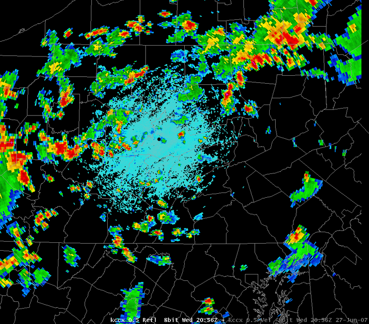 |
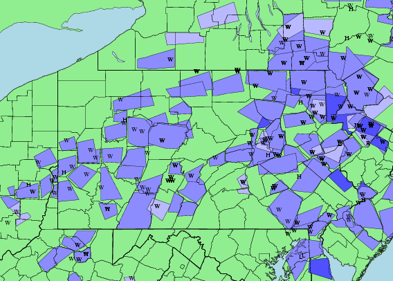
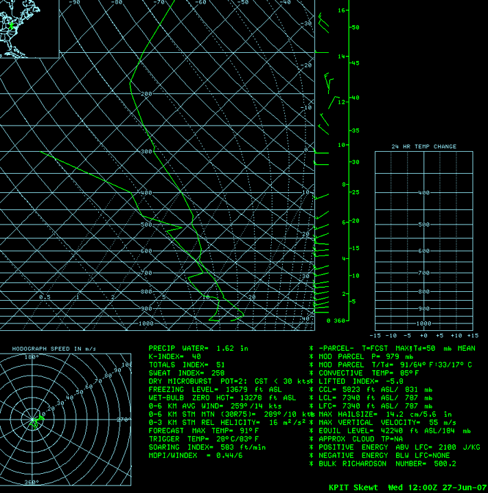
| Graphical Plot of Severe Weather Warnings Issued and Reports | Pittsburgh Upper Air Sounding | Radar Plan View of Reflectivity around 2100Z (5PM EDT) |
Storm Reports
LSRCTP

PRELIMINARY LOCAL STORM REPORT
NATIONAL WEATHER SERVICE STATE COLLEGE PA
859 PM EDT THU JUN 28 2007

..TIME...   ...EVENT...      ...CITY LOCATION...     ...LAT.LON...
..DATE...   ....MAG....      ..COUNTY LOCATION..ST.. ...SOURCE....
            ..REMARKS..

0130 PM     TSTM WND DMG     3 W BERWICK             41.06N 76.31W
06/27/2007                   COLUMBIA           PA   EMERGENCY MNGR

            NUMEROUS LARGE TREES DOWN ON THE WEST SIDE OF BERWICK

0300 PM     TSTM WND DMG     DUNCANNON               40.40N 77.03W
06/27/2007                   PERRY              PA   EMERGENCY MNGR

            NUMEROUS LARGE TREES AND WIRES DOWN IN DUNCANNON

0324 PM     TSTM WND DMG     GENESEE                 41.98N 77.90W
06/27/2007                   POTTER             PA   LAW ENFORCEMENT

            TREES AND LIMBS DOWN IN GENESEE TWP

0400 PM     TSTM WND DMG     1 S LAWRENCEVILLE       41.98N 77.13W
06/27/2007                   TIOGA              PA   EMERGENCY MNGR

            TREES DOWN ON ROUTE 15

0405 PM     TSTM WND DMG     2 SW LEBANON            40.32N 76.45W
06/27/2007                   LEBANON            PA   EMERGENCY MNGR

            TREES ACROSS ROAD

0405 PM     TSTM WND DMG     LEBANON                 40.34N 76.42W
06/27/2007                   LEBANON            PA   EMERGENCY MNGR

            NUMEROUS LARGE TREES AND WIRES DOWN

0415 PM     TSTM WND DMG     LAWRENCEVILLE           42.00N 77.13W
06/27/2007                   TIOGA              PA   EMERGENCY MNGR

            LARGE TREE DOWN ON AN ELDERLY CARE HOME IN LAWRENCEVILLE

0530 PM     TSTM WND DMG     3 NW CURWENSVILLE       41.00N 78.56W
06/27/2007                   CLEARFIELD         PA   EMERGENCY MNGR

            TREES AND WIRES DOWN ACROSS GREENVILLE PIKE

0535 PM     TSTM WND DMG     HUNTINGDON              40.50N 78.01W
06/27/2007                   HUNTINGDON         PA   CO-OP OBSERVER

            NUMEROUS TREES AND POWERS LINES DOWN IN HUNTINGDON.

0539 PM     TSTM WND DMG     WATSONTOWN              41.08N 76.86W
06/27/2007                   NORTHUMBERLAND     PA   EMERGENCY MNGR

            PORTIONS OF A ROOF BLOWN OFF A LARGE WAREHOUSE

0540 PM     TSTM WND DMG     LEWISBURG               40.96N 76.89W
06/27/2007                   UNION              PA   EMERGENCY MNGR

            LARGE LIMBS AND SMALL TREES DOWN IN AND AROUND LEWISBURG

0615 PM     TSTM WND DMG     3 N DANVILLE            41.00N 76.61W
06/27/2007                   MONTOUR            PA   DEPT OF HIGHWAYS

            NUMEROUS TREES DOWN COUNTY WIDE

0620 PM     TSTM WND DMG     HOLLIDAYSBURG           40.43N 78.39W
06/27/2007                   BLAIR              PA   LAW ENFORCEMENT

            TREES AND WIRES DOWN

0620 PM     TSTM WND DMG     DUNCANSVILLE            40.43N 78.43W
06/27/2007                   BLAIR              PA   LAW ENFORCEMENT

            TREES AND WIRES DOWN

0620 PM     TSTM WND DMG     LAKEMONT                40.47N 78.38W
06/27/2007                   BLAIR              PA   LAW ENFORCEMENT

            TREES AND WIRES DOWN

0620 PM     TSTM WND DMG     5 ESE WASHINGTONVILLE   41.02N 76.59W
06/27/2007                   MONTOUR            PA   LAW ENFORCEMENT

            NURMEROUS TREES DOWN IN WEST HEMLOCK TWP.

0623 PM     TSTM WND DMG     TIPTON                  40.64N 78.30W
06/27/2007                   BLAIR              PA   LAW ENFORCEMENT

            TREES AND WIRES DOWN

0625 PM     TSTM WND DMG     3 NW BLOOMSBURG         41.03N 76.50W
06/27/2007                   COLUMBIA           PA   DEPT OF HIGHWAYS

            NUMEROUS TREES DOWN COUNTY WIDE

0640 PM     TSTM WND DMG     3 NE MILROY             40.75N 77.55W
06/27/2007                   MIFFLIN            PA   EMERGENCY MNGR

            NUMEROUS LARGE TREES DOWN.

0649 PM     TSTM WND DMG     WINDBER                 40.23N 78.83W
06/27/2007                   SOMERSET           PA   LAW ENFORCEMENT

            MULTIPLE TREES DOWN.

0650 PM     TSTM WND DMG     3 E GEISTOWN            40.29N 78.81W
06/27/2007                   CAMBRIA            PA   EMERGENCY MNGR

            NUMEROUS LARGE TREES DOWN

0655 PM     TSTM WND DMG     2 E HOLLIDAYSBURG       40.43N 78.36W
06/27/2007                   BLAIR              PA   LAW ENFORCEMENT

            TREES DOWN

0705 PM     TSTM WND DMG     MOUNT CARMEL            40.80N 76.41W
06/27/2007                   NORTHUMBERLAND     PA   EMERGENCY MNGR

            TREES DOWN ON WIRES ACROSS MT. UNION.

0715 PM     TSTM WND DMG     SELINSGROVE             40.80N 76.87W
06/27/2007                   SNYDER             PA   LAW ENFORCEMENT

            MULTIPLE TREES DOWN IN PENN AND FRANKLIN TWPS.

0725 PM     TSTM WND DMG     JOHNSTOWN               40.33N 78.92W
06/27/2007                   CAMBRIA            PA   LAW ENFORCEMENT

            6 TREES REPORTED DOWN IN CITY OF JOHNSTOWN.

0726 PM     TSTM WND DMG     ASHLAND                 40.78N 76.35W
06/27/2007                   SCHUYLKILL         PA   EMERGENCY MNGR

            NUMEROUS LARGE TREES DOWN IN ASHLAND

0750 PM     HAIL             SHAMOKIN                40.79N 76.55W
06/27/2007  E0.75 INCH       NORTHUMBERLAND     PA   TRAINED SPOTTER

            PENNY SIZE HAIL ALONG WITH A WIND GUST TO 69 MPH IN
            SHAMOKIN.

0755 PM     TSTM WND DMG     HUNTINGDON              40.50N 78.01W
06/27/2007                   HUNTINGDON         PA   EMERGENCY MNGR

            TREES AND WIRES DOWN ACROSS HUNTINGDON BOROUGH

0805 PM     TSTM WND DMG     2 W DANVILLE            40.96N 76.65W
06/27/2007                   MONTOUR            PA   EMERGENCY MNGR

            NUMEROUS LARGE TREES DOWN

0807 PM     TSTM WND DMG     ASHLAND                 40.78N 76.35W
06/27/2007                   SCHUYLKILL         PA   LAW ENFORCEMENT

            REPORT OF SPORADIC TREE DAMAGE IN BARRY, BUTLER, CLINE,
            AND MAHANOY TWPS FROM SECOND LINE OF STORMS.

0820 PM     TSTM WND DMG     1 NW BETHEL             39.83N 76.17W
06/27/2007                   LANCASTER          PA   EMERGENCY MNGR

            REPORT OF WIRES AND TREES DOWN AT RESIDENCE IN DRUMORE.

1000 PM     TSTM WND DMG     MILLERSVILLE            40.00N 76.35W
06/27/2007                   LANCASTER          PA   BROADCAST MEDIA

            TREES AND POWER LINES DOWN IN MANOR TWP NEAR
            MILLERSVILLE.


&&

$$

PAH
 |
Media use of NWS Web News Stories is encouraged! Please acknowledge the NWS as the source of any news information accessed from this site. |
|


 Send Us a Report