Overview
|
June 22nd was a highly unstable day, and became the busiest and most widespread severe weather day of the year so far. A thunderstorm wind gust/squall estimated at 60 mph occurred at the NWS Office in State College. This squall lasted almost 2 minutes, and was accompanied by pea size hail at the office. Numerous large hail reports also came in from many locations in and around the rest of State College. Many trees were downed, as the storms were mainly bow echoes, with occasional rotation present. Numerous reports of large hail also came in from across Central PA. |
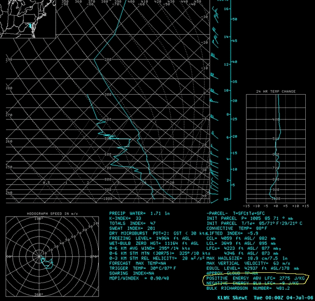 Balloon Sounding from KLWX (Washington DC). See the Positive Area (a.k.a. "B+" or "CAPE") is almost 2800 J/kg! That is Highly Unstable. |
Radar
 |
 |
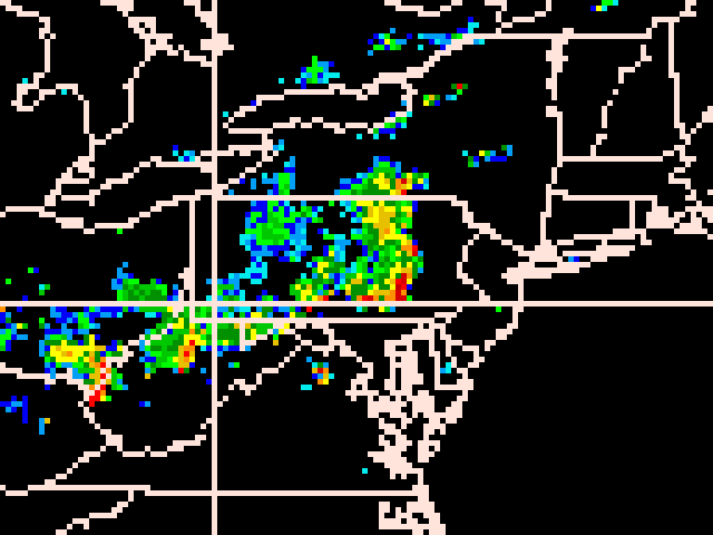 |
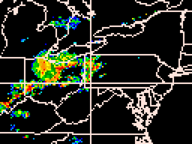
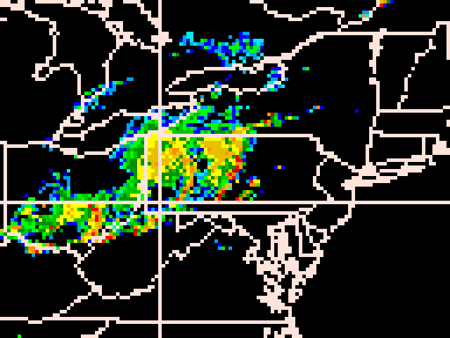
| Regional Radar Mosaic from 21z 6/22/06 (5pm EDT 6/22). | Regional Radar Mosaic from 00z 6/23/06 (8pm EDT 6/22). | Regional Radar Mosaic from 02z 6/23/06 (10pm EDT 6/22). |
Storm Reports
NWUS51 KCTP 230333
LSRCTP
PRELIMINARY LOCAL STORM REPORT...SUMMARY
NATIONAL WEATHER SERVICE STATE COLLEGE PA
1132 PM EDT THU JUN 22 2006
..TIME... ...EVENT... ...CITY LOCATION... ...LAT.LON...
..DATE... ....MAG.... ..COUNTY LOCATION..ST.. ...SOURCE....
..REMARKS..
0540 PM TSTM WND DMG WARREN 41.84N 79.14W
06/22/2006 WARREN PA NWS EMPLOYEE
TREES DOWN ON POWER LINES
0543 PM HAIL DUBOIS 41.12N 78.76W
06/22/2006 E0.75 INCH CLEARFIELD PA PUBLIC
0548 PM TSTM WND GST WARREN 41.84N 79.14W
06/22/2006 E65.00 MPH WARREN PA TRAINED SPOTTER
PEA SIZED HAIL EXPERIENCED WITH THUNDERSTORM WINDS
0625 PM TSTM WND DMG DUBOIS 41.12N 78.76W
06/22/2006 CLEARFIELD PA LAW ENFORCEMENT
TREES AND WIRES DOWN
0632 PM TSTM WND DMG ST. MARYS 41.43N 78.56W
06/22/2006 ELK PA LAW ENFORCEMENT
TREES DOWN
0640 PM TSTM WND DMG JOHNSTOWN 40.33N 78.92W
06/22/2006 CAMBRIA PA EMERGENCY MNGR
TREES AND WIRES DOWN
0645 PM TSTM WND DMG CARROLLTOWN 40.60N 78.71W
06/22/2006 CAMBRIA PA EMERGENCY MNGR
TRAILER ROOF BLOWN OFF AND TREES/WIRES DOWN
0650 PM TSTM WND DMG EBENSBURG 40.49N 78.73W
06/22/2006 CAMBRIA PA EMERGENCY MNGR
UTILITY POLE FELL ON TRACTOR TRAILER
0655 PM TSTM WND DMG CLEARFIELD 41.02N 78.44W
06/22/2006 CLEARFIELD PA LAW ENFORCEMENT
TREES DOWN
0705 PM TSTM WND DMG 2 SE DRIFTWOOD 41.32N 78.11W
06/22/2006 CAMERON PA LAW ENFORCEMENT
TREES DOWN ON ROUTE 872
0745 PM HAIL STATE COLLEGE 40.79N 77.86W
06/22/2006 E1.00 INCH CENTRE PA PUBLIC
0745 PM HAIL 5 W STATE COLLEGE 40.79N 77.95W
06/22/2006 E0.50 INCH CENTRE PA NWS EMPLOYEE
0745 PM HAIL STATE COLLEGE 40.79N 77.86W
06/22/2006 E0.75 INCH CENTRE PA TRAINED SPOTTER
0745 PM TSTM WND GST STATE COLLEGE 40.79N 77.86W
06/22/2006 E60.00 MPH CENTRE PA NWS EMPLOYEE
PEA SIZED HAIL ACCOMPANIED WINDS.
0810 PM TSTM WND DMG SHADE GAP 40.18N 77.87W
06/22/2006 HUNTINGDON PA NWS EMPLOYEE
TWO TREES DOWN ON ROUTE 522
0820 PM TSTM WND DMG MIFFLINBURG 40.92N 77.05W
06/22/2006 UNION PA LAW ENFORCEMENT
TREES DOWN
0820 PM TSTM WND DMG HARTLETON 40.90N 77.16W
06/22/2006 UNION PA LAW ENFORCEMENT
TREES DOWN
0826 PM TSTM WND GST LOCK HAVEN 41.14N 77.45W
06/22/2006 E60.00 MPH CLINTON PA AIRPLANE PILOT
WILLIAMSPORT FLIGHT SERVICE RELAY PILOT REPORT OF 60MPH
WINDS AND SIGHTING OF FUNNEL CLOUD
0830 PM TSTM WND DMG 5 W MONTOURSVILLE 41.24N 77.02W
06/22/2006 LYCOMING PA TRAINED SPOTTER
LARGE MAPLE TREE DOWN
0830 PM TSTM WND DMG WILLIAMSPORT 41.24N 77.02W
06/22/2006 LYCOMING PA LAW ENFORCEMENT
TREES AND WIRES DOWN
0835 PM TSTM WND GST WILLIAMSPORT 41.24N 77.02W
06/22/2006 M59.00 MPH LYCOMING PA OFFICIAL NWS OBS
0840 PM TSTM WND DMG SHERMANSDALE 40.35N 77.18W
06/22/2006 PERRY PA LAW ENFORCEMENT
LARGE TREES DOWN
0840 PM TSTM WND DMG NEWPORT 40.48N 77.13W
06/22/2006 PERRY PA LAW ENFORCEMENT
LARGE TREES DOWN
0840 PM TSTM WND DMG LIVERPOOL 40.57N 76.99W
06/22/2006 PERRY PA LAW ENFORCEMENT
LARGE TREES DOWN
0840 PM TSTM WND DMG MONTOURSVILLE 41.25N 76.92W
06/22/2006 LYCOMING PA LAW ENFORCEMENT
TREES AND WIRES DOWN
0842 PM TSTM WND DMG LOYALSOCKVILLE 41.32N 76.92W
06/22/2006 LYCOMING PA LAW ENFORCEMENT
TREES AND WIRES DOWN
0846 PM TSTM WND DMG SUNBURY 40.86N 76.79W
06/22/2006 NORTHUMBERLAND PA LAW ENFORCEMENT
NUMEROUS TREES DOWN
0900 PM TSTM WND DMG 3 S BLOOMSBURG 40.86N 76.79W
06/22/2006 NORTHUMBERLAND PA TRAINED SPOTTER
TREES AND WIRES DOWN
0900 PM TSTM WND DMG SHAMOKIN 40.79N 76.55W
06/22/2006 NORTHUMBERLAND PA TRAINED SPOTTER
TREES AND WIRES DOWN
0910 PM TSTM WND DMG LYKENS 40.56N 76.70W
06/22/2006 DAUPHIN PA LAW ENFORCEMENT
TREES AND WIRES DOWN
0910 PM TSTM WND DMG 3 S BLOOMSBURG 40.95N 76.46W
06/22/2006 COLUMBIA PA TRAINED SPOTTER
TREES AND WIRES DOWN
0911 PM TSTM WND DMG SHAMOKIN 40.79N 76.55W
06/22/2006 NORTHUMBERLAND PA LAW ENFORCEMENT
TREES DOWN
0911 PM TSTM WND DMG SELINSGROVE 40.80N 76.87W
06/22/2006 SNYDER PA LAW ENFORCEMENT
SEVERAL TREES DOWN
0915 PM TSTM WND DMG 5 NE CARLISLE 40.25N 77.14W
06/22/2006 CUMBERLAND PA LAW ENFORCEMENT
TREES DOWN IN MIDDLESEX TOWNSHIP AND POWER OUTAGES IN
VARIOUS PARTS OF COUNTY
0927 PM TSTM WND DMG HARPER TAVERN 40.41N 76.57W
06/22/2006 LEBANON PA LAW ENFORCEMENT
TREES DOWN
0927 PM TSTM WND DMG GORDON 40.75N 76.34W
06/22/2006 SCHUYLKILL PA LAW ENFORCEMENT
TREES DOWN
0940 PM TSTM WND DMG LEBANON 40.34N 76.42W
06/22/2006 LEBANON PA LAW ENFORCEMENT
TREES DOWN
0945 PM TSTM WND DMG EPHRATA 40.18N 76.18W
06/22/2006 LANCASTER PA LAW ENFORCEMENT
TREES DOWN
0954 PM TSTM WND DMG MANHEIM 40.16N 76.40W
06/22/2006 LANCASTER PA LAW ENFORCEMENT
TREES DOWN
1000 PM HAIL NEWMANSTOWN 40.35N 76.21W
06/22/2006 M1.00 INCH LEBANON PA LAW ENFORCEMENT
1000 PM TSTM WND DMG 3 SW LEBANON 40.31N 76.46W
06/22/2006 LEBANON PA LAW ENFORCEMENT
TREES DOWN
1000 PM TSTM WND DMG 2 NE NEW HOLLAND 40.12N 76.06W
06/22/2006 LANCASTER PA LAW ENFORCEMENT
TREES DOWN
&&
$$
RXR/MBC
 |
Media use of NWS Web News Stories is encouraged! Please acknowledge the NWS as the source of any news information accessed from this site. |
|


 Send Us a Report