Overview
|
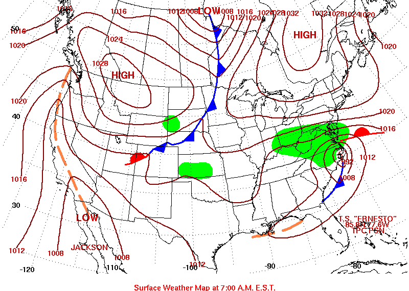
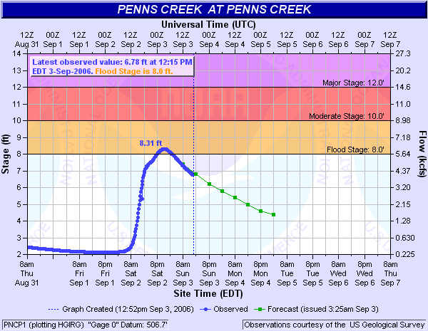
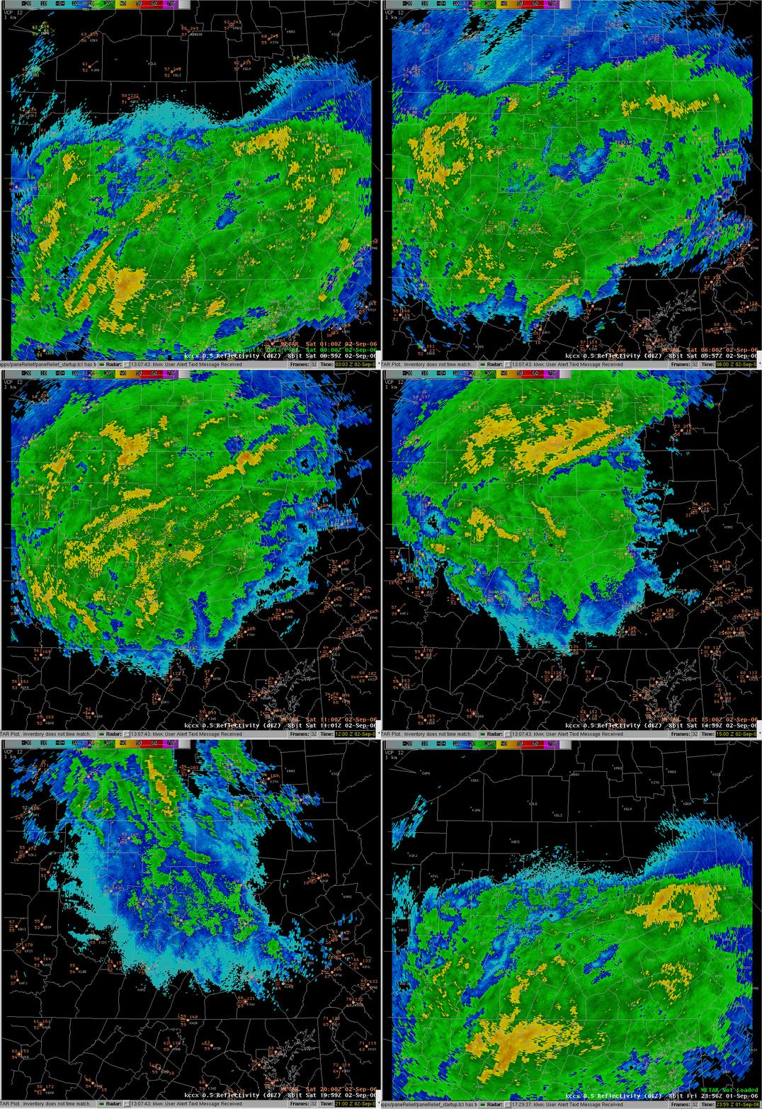
Tropical Storm Ernesto slid up the East Coast of the U.S. on Thursday (Aug 31st) and Friday (Sep 1st), losing it's tropical characteristics as it interacted with a stationary boundary in place over VA/MD. It also had to butt heads with a strong High pressure system in place over New England and Eastern Canada. This interaction brought a deep, Easterly flow of air off the Atlantic Ocean into Central PA. This is a usual set-up for heavy rainfall in Central PA. The rain started Friday morning along the Maryland Border, and crept northward through the day, reaching the New York Border just after nightfall Friday Night (late on the 1st). You can see how slowly this event started by comparing the radar imagery during the day Friday. At 8:00 am Fri the leading edge of the radar echoes was along the PA/MD border. As the day progressed this leading edge migrated slowly north to central PA by 2:00 pm and just reached northern PA by 8:00 pm Friday night. This slow northward movement of the rain shield was a result of drying and evaporation due to a relatively deep dry layer of colder air to the north caused by a strong high pressure system anchored over New England. The rain became heaviest overnight, and lasted into Saturday Afternoon and Evening (the 2nd). An interactive loop of radar reflectivity overnight through Saturday reveals many areas of moderate rainfall (yellow area) moving from south to north across central Pennsylvania. A static loop of radar estimated 3 hourly accumulation also shows areas of more concentrated rainfall moving across PA overnight. Forecast Precipitation amounts (QPF) showed a general swath of 1-2 inches per 6 hour (06:00, 12:00, 18:00, 00:00 UTC) also moving from south to north across the area anticipating heavy rains from Ernesto to move into southern and central New York and then drier air in its wake. During the afternoon Saturday the bulk of the low level moisture remained over eastern PA and NJ where higher dewpoints indicated good on-shore low level moisture flow at 21:00 UTC. This flow of moisture was also revealed by the banded structure of radar reflectivity evident on the KDIX WSR 88-D radar. Water vapor imagery showed a deep layer of moist air flowing across PA as a persistant and strong east to southeast flow to the north of the low pressure center fed Atlantic moisture into PA. An animation of water vapor, surface pressure, and winds from 01:00 UTC to 21:00 UTC (9:00 pm Fri to 5:00 pm Sat) shows this deep layer moist air being replaced by drier air as the low moved north into central PA. An animation of the the RUC model upper air analysis for a point near State College for the period 18:00 UTC Sat to 06:00 UTC Sun morning showed this deep layer moisture eroding as drier air moved in aloft leaving only a shallow layer of moist air near the surface. The change in precipitatble water from 07:00 UTC to 12:00 UTC also shows this. The remnants of Ernesto continued to weaken as it moved north into colder air and the surface low continued to fill and weaken during the day. However, light rain continued for most of the day Saturday despite mid level drying. A more comprehensive study by Rich Grumm and John LaCorte, explains why this occurred. Before the rain from Ernesto was over it produced a widespread 1-3 inch rainfall over Central PA, with a few locations picking up over 4 inches - see text summary and images below. This pushed many area creeks and streams to bankfull, but only pushed one river gage over Flood Stage (Penns Creek at Penns Creek, PA). The 48 hour storm total total precipitation using a combination of COOP and rain gauge data (courtesy of the MARFC) details the 2 day rainfall amounts (from 7 am Fri to 7 am Sun) across PA. |
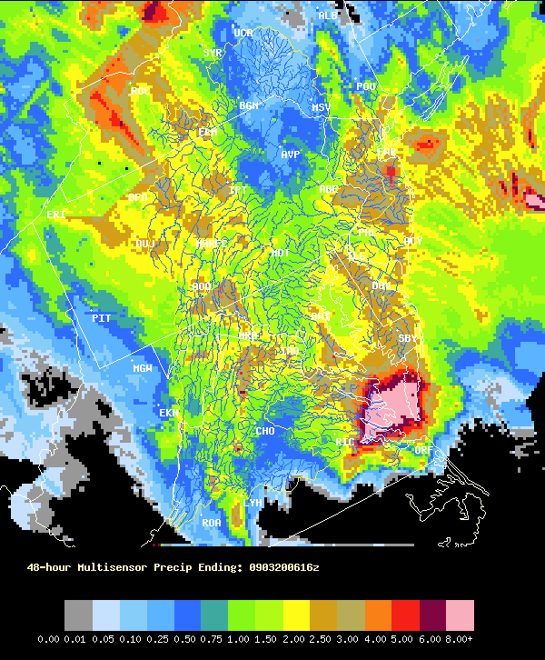 Ernesto Storm Total Precip from Multi-Sensor Precipitation Estimates provided by MARFC |
 |
 |
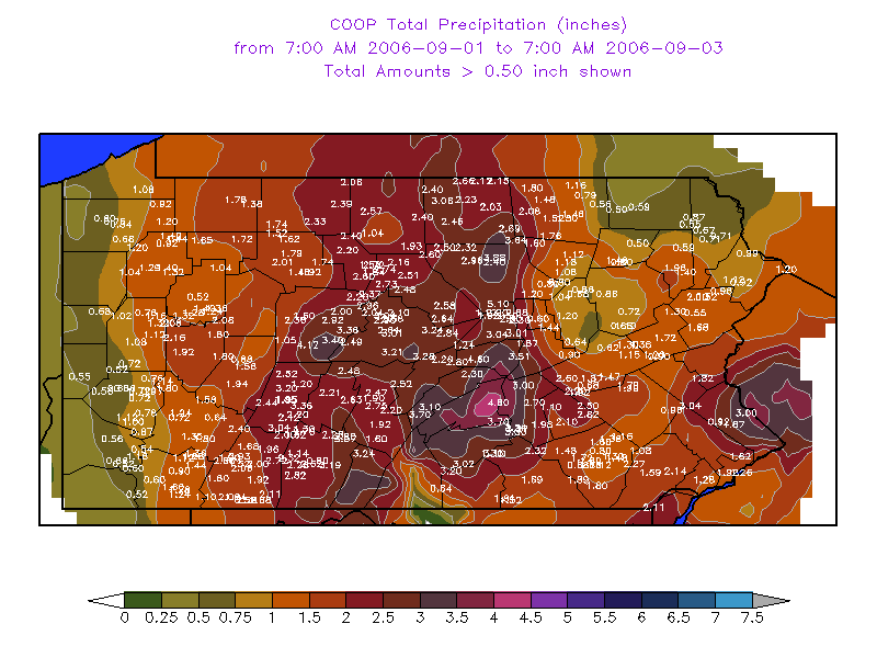 |
| Surface Map, 7 AM EST (1200 UTC), Sep 1st, 2006 | Hydrograph of river stages for Penns Creek Gage during and after rain from Ernesto | COOP Rainfall Amounts throughout the storm |
Radar
Click for Larger Image
 |
| Radar GIF Loop |
Rain Reports
PUBLIC INFORMATION STATEMENT
SPOTTER REPORTS
NATIONAL WEATHER SERVICE STATE COLLEGE PA
1235 PM EDT SUN SEP 3 2006

THE FOLLOWING ARE UNOFFICIAL OBSERVATIONS TAKEN DURING THE PAST 30
HOURS FOR TROPICAL STORM ERNESTO THAT AFFECTED OUR REGION.
APPRECIATION IS EXTENDED TO HIGHWAY DEPARTMENTS...COOPERATIVE
OBSERVERS...SKYWARN SPOTTERS AND MEDIA FOR THESE REPORTS.  THIS
SUMMARY IS ALSO AVAILABLE ON OUR HOME PAGE AT WEATHER.GOV/CTP

**********TROPICAL STORM ERNESTO TOTAL RAINFALL****************

LOCATION          STORM TOTAL    TIME/DATE    COMMENTS
                     RAINFALL       OF
                     (INCHES)   MEASUREMENT


PENNSYLVANIA

...ADAMS COUNTY...
   YORK SPRINGS          2.51  1110 AM   9/3  PUBLIC

...BEDFORD COUNTY...
   EVERETT               3.19  1141 AM   9/3
   SAXTON                3.07  1141 AM   9/3
   BUFFALO MILLS         2.72  1140 AM   9/3
   WOLFSBURG             2.62  1141 AM   9/3

...BLAIR COUNTY...
   ALTOONA               2.70   830 AM   9/2   ASOS REPORT
   WILLIAMSBURG          2.63  1142 AM   9/3
   TYRONE                2.48  1142 AM   9/3

...CAMBRIA COUNTY...
   PATTON                3.25  1145 AM   9/3
   EBENSBURG             1.85  1143 AM   9/3
   JOHNSTOWN             1.74   830 AM   9/2   ASOS REPORT

...CAMERON COUNTY...
   STEVENSON DAM         2.72  1145 AM   9/3
   SINNEMAHONING         2.60  1145 AM   9/3
   EMPORIUM              2.20  1143 AM   9/3

...CENTRE COUNTY...
   STATE COLLEGE         3.21  1147 AM   9/3
   CLARENCE              3.04  1147 AM   9/3
   PHILIPSBURG           2.49  1221 PM   9/3

...CLEARFIELD COUNTY...
   DU BOIS               0.19   830 AM   9/2   ASOS REPORT

...CLINTON COUNTY...
   LOCK HAVEN            2.58  1148 AM   9/3
   RENOVO                2.51  1147 AM   9/3

...COLUMBIA COUNTY...
   BENTON                0.43   700 AM   9/2

...CUMBERLAND COUNTY...
   PINE GROVE FURNACE    3.02  1149 AM   9/3
   SHIPPENSBURG          2.36   700 AM   9/2
   NEW CUMBERLAND        1.36   830 AM   9/2   ASOS REPORT

...DAUPHIN COUNTY...
   HARRISBURG            3.37  1151 AM   9/3
   DEHART DAM            2.70  1151 AM   9/3
   HERSHEY               1.98  1152 AM   9/3

...ELK COUNTY...
   RIDGWAY               2.01  1154 AM   9/3
   WILCOX                1.69  1155 AM   9/3

...FRANKLIN COUNTY...
   UPPER STRASBURG       2.10   700 AM   9/2
   SOUTH MOUNTAIN        0.64  1155 AM   9/3

...HUNTINGDON COUNTY...
   ENTRIKEN              2.75  1157 AM   9/3
   HUNTINGDON            2.47  1156 AM   9/3

...JUNIATA COUNTY...
   PORT ROYAL            2.90  1051 AM   9/3   PUBLIC

...LANCASTER COUNTY...
   GLEN MOORE            2.06  1158 AM   9/3
   SAFE HARBOR           1.89  1200 PM   9/3
   NEW HOLLAND           1.48  1159 AM   9/3
   HOLTWOOD              1.28  1159 AM   9/3
   LITITZ                0.95  1034 AM   9/2
   MILLERSVILLE          0.71   700 AM   9/2

...LYCOMING COUNTY...
   WILLIAMSPORT          4.21  1202 PM   9/3

...MCKEAN COUNTY...
   PORT ALLEGANY         2.39  1205 PM   9/3
   CLERMONT              2.33  1203 PM   9/3
   KANE                  1.74  1204 PM   9/3
   BRADFORD              0.48   830 AM   9/2   ASOS REPORT

...MONTOUR COUNTY...
   DANVILLE              1.44  1205 PM   9/3

...NORTHUMBERLAND COUNTY...
   SUNBURY               1.87  1206 PM   9/3
   HERNDON               1.10   609 AM   9/2

...POTTER COUNTY...
   COUDERSPORT           2.57  1206 PM   9/3

...SCHUYLKILL COUNTY...
   PINE GROVE            2.20  1206 PM   9/3
   MAHANOY CITY          0.62   700 AM   9/2

...SNYDER COUNTY...
   SELINSGROVE           3.51  1207 PM   9/3

...SOMERSET COUNTY...
   LAUREL SUMMIT         3.06  1208 PM   9/3
   MEYERSDALE            2.27  1209 PM   9/3
   GLENCOE               2.11  1208 PM   9/3
   SOMERSET              2.06  1209 PM   9/3
   BOYNTON               2.00  1210 PM   9/3
   COMPTON               1.76   700 AM   9/2
   CONFLUENCE            1.10  1208 PM   9/3

...SULLIVAN COUNTY...
   LAPORTE               1.18  1211 PM   9/3

...TIOGA COUNTY...
   SABINSVILLE           3.06  1212 PM   9/3
   WELLSBORO             2.46  1213 PM   9/3
   COWANESQUE DAM        2.12  1213 PM   9/3

...UNION COUNTY...
   LEWISBURG             3.01  1214 PM   9/3
   WHITE DEER            1.36   810 AM   9/2

...WARREN COUNTY...
   WARREN                1.78  1215 PM   9/3
   CHANDLERS VALLEY      1.76  1214 PM   9/3
   SUGAR GROVE           0.23   700 AM   9/2

...YORK COUNTY...
   YORK HAVEN            2.32  1215 PM   9/3
   HANOVER               1.81  1215 PM   9/3

$$

CRUZ
 |
Media use of NWS Web News Stories is encouraged! Please acknowledge the NWS as the source of any news information accessed from this site. |
 |